
SIGEP
Geological and
Paleontological Sites of Brazil - 072
Pai
InŠcio Hill, Bahia state, Brazil
Date: 09/10/1999
Augusto J. Pedreira
augusto.pedreira@terra.com.br
Luiz F. Costa Bomfim
cprmsa@bahianet.com.br
CPRM- ServiÁo Geolůgico do Brasil
Av. Ulysses Guimar„es, 2862
41.213-000 Salvador, Bahia, Brasil
© Pedreira,A.J.; Bomfim,L.F.C. 1999. Pai InŠcio Hill, Bahia state, Brazil. In: Schobbenhaus,C.; Campos,D.A.; Queiroz,E.T.; Winge,M.; Berbert-Born,M. (Edit.) SŪtios Geolůgicos e Paleontolůgicos do Brasil.
Published
9/10/1999 on Internet at the address http://www.unb.br/ig/sigep/sitio072/sitio072english.htm [Actually
https://sigep.eco.br/sitio072/sitio072english.htm]
[SEE
PRINTED CHAPTER IN PORTUGUESE] (The above bibliographic reference of author copy rights is required for any use of this article in any media, being forbidden the use for any commercial purpose)
|
ABSTRACT
Pai InŠcio Hill, together with the
Camelo and Morr„o hills, consist of erosional outliers located in the limbs of Pai
InŠcio Anticline, in the central region of Bahia State. In this fold, whose axis trends
north-south, is exposed the contact between the ParaguaÁu and Chapada Diamantina groups:
the former consists of fine grained sandstones, siltstones and argillites and the latter,
represented by the Tombador Formation, is formed by sandstones and occasionally diamond
bearing conglomerates. The contact between the two groups is a surface that sepparates two
depositional system tracts: a lower one, of transitional environment, and upper one, of
continental environment.
The landscape of the hills, the
geological struture, and the vegetal species that grow in the region, form a unique system
for multidisciplinary study. The region is located within the limits of the Chapada
Diamantina National Park and the Marimbus-Iraquara Environmental Protection Area, and is
classified as "rigorous protection area".
INTRODUCTION
The Pai InŠcio Hill (photo 1),
considered by many as the milestone of the Chapada Diamantina, constitutes na erosive
outlier 140 meter high and with an altitude of 1.120m, preserved along the western limb of
Pai InŠcio Anticline (photo 2). It is located in Palmeiras municipality that is part of
the Central Chapada Diamantina region that encompasses, wholly or in part, the LenÁůis,
AndaraŪ, MucugÍ, Seabra, ItaetÍ, Ibicoara and Iraquara municipalities.
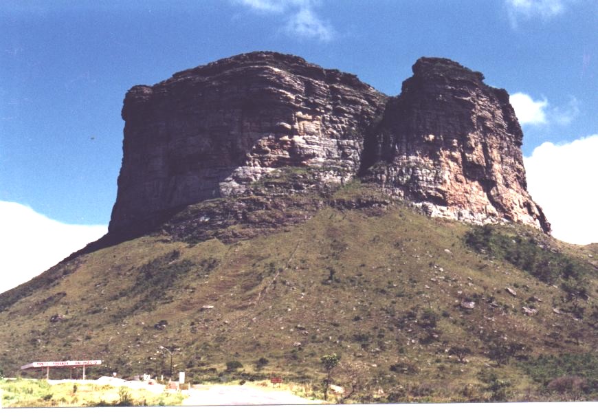
Photo 1 – Eastern escarpment of Pai InŠcio Hill, seen
from BR-242 road. Photo by Fileno P. dos Santos.
The Chapada Diamantina is the extension
in the State of Bahia, of the EspinhaÁo Range System. With average altitudes around 1.000
meters and peaks 1.700 meters high, this platean soars like a wall that separates the S„o
Francisco river valley from the eastern terrains that extend until the coast. The climate
in the region is semi-moist tropical with the rainy months between November and February
and the dry ones betwen May and September. The temperature in the region is mild, with
yearly average of 20oC. The vegetation in the summit of the hill consists of
orchids, cacti, lichens and mosses, among other species. Some of them dwell in the smooth
surfaces of the rocks.
Geologically the area is in the domain of
the terrigenous meta-sediments of the Chapada Diamantina Syneclisis and is characterized
by gentle folds with north-south trending axes. The predominting lithologies are fine
grained sandstones, siltstones and argillites of the ParaguaÁu Group, overlain by
conglomerates, sandstones and pelites of the Chapada Diamantina Group, represented in the
Pai InŠcio Hill, by Tombador Formation. The conglomerates of this formation are
considered as the secondary repositories of the diamond mineralizations of the region. The
washing of diamonds in the region, activity that survives until the present times, began
late in the XVIII century, reaching its peak by middle XIX century. Then, the hamlet of S.
Isabel do ParaguaÁu (presently the town MucugÍ), had more than 25.000 inhabitants.
From the summit of the hill, one looking
south sees the majestic sight of the Pai InŠcio Anticline with its north-south trending
axis and bounded west by the Bacia range and east by Chapadinha range. About 10km south,
outstants the stony "castle"of the Morr„o, whereas 3km to north one sees the
Camelo or Calumbi Hill, back ground of the opening scenery of a TV opera sometime ago.
The argillites, siltstones and fine
grained sandstones of the ParaguaÁu Group have lesser resistance to the runoff than the
conglomerates and sandstones of the Tombador Formation. On the other hand, the former
rocks fold more easily than the latter; these in general are fractured. So, with the
formation of the anticline the Tombador Formation fractured in several places, easing the
penetration of the rain water, that eroded the softer rocks of the ParaguaÁu Group. These
processes gave birth to the present landscape, schematicaly shown in figure 3 and in the
accompanying photos.
LOCATION
Pai InŠcio Hill is located in the
central region of Bahia State, where the meridian 41o28’30’’
crosses the parallel 12o27’30’’ and is 28km far from the town of
LenÁůis (figure 1). It marks the northern limit of the Chapada Diamantina National Park,
with na area of 1520 sq. km., established on Sep. 17, 1985, by the Federal Decree no
91.655.
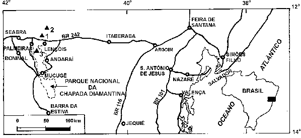
Figure 1 – Location map of the Pai
Inacio Camelo and Morr„o Hills. Inset shows the situation of the region in Brazil.
HISTORICAL DATA
The name Pai InŠcio Hill was given after
a legend envolving a slave named InŠcio, who secretively flirted the daughter of his
master, who owned large diamond washings. Once discovered the affair, the master put
several accomplices to chase the slave. During the flight, InŠcio found shelter in the
hill, but was discovered and then, he jumped from the summit, using his umbrella as a
parachute. It is told that, after the jump he was scen running in a nearby valley, but was
never found again.
The geology of Pai InŠcio Hill is
closely related to the geology of the Chapada Diamantina, that has been studied since the
XIX century. The discovery of diamonds in 1844 in MucugÍ region (Cathtarine, 1986), lead
to intesive studies about the region.
The oldest work, is the report of the
General Inspector of the Diamond-bearing Terrains, Benedito Marques da Silva Acau„,
presented to the Imperial Government on April 15, 1847 (Acau„, 1847). In this report, he
described the geology, geomorphology and mineral resources of Santa Isabel do ParaguaÁu
(presently MucugÍ), Chique-Chique (presently Igatu), AndaraŪ, LenÁůis and Palmeiras
(figure 1), but without giving names to the formations. Later, in 1906, Derby named the
lower sequence of Chapada Diamantina sediments of ParaguaÁu Group, and the upper one,
Lavras Group. In 1959, W. Kegel described in the section Seabra-LenÁůis-Amparo (hamlet
located 40km west of Itaberaba; figure 1) that includes Pai InŠcio Hill, the whole
clastic sequence cropping out in this sector of the Chapada Diamantina. He described the
Upper, Middle and Lower Lavras units; the former two respectively correspond to the Lavras
and ParaguaÁu groups. About 150km northeast from the Pai InŠÁio Hill, in the Tombador
range (Pedreira & Rocha, 1999), J. C. Branner in 1910 described the Tombador and
Caboclo formations, suggesting that the diamond bearing conglomerates that cropped out
above them in the neighborhood of Morro do Chapťu and Ventura were correlated to Derby
Lavras Group.
In 1969, J. .F. Mascarenhas adopted the
stratigraphy proposed by Brito Neves (1967) that added above the Caboclo Formation, the
Morro do Chapťu Formation, describing above the latter, the LenÁůis Formation. Later,
Pedreira & Mascarenhas (1974), demonstrated that the Tombador Formation that crops out
in the Tombador range was the same that crops out the SincorŠ range, so that the
correlation made by Branner (1910) between the diamond bearing formations of Morro do
Chapťu and Ventura, and the diamond washings studied by Derby (1905), was not valid;
between the two, there is a pelitic sequence (Branner’s Caboclo Formation or
Mascarenhas' LenÁůis Formation). In 1990, the CPRM – Mineral Resources Exploration
Company mapped the central-eastern sector of the Chapada Diamantina emphasizing the more
modern concepts of depositional systems. In the sector of Pai InŠcio Hill, the lower
depositional sequence corresponds to the ParaguaÁu Group and comprises sandy and
clayey-sandy lithofacies deposited in a continental-transitional environment. The upper
sequence (Tombador Formation) comprises fluvio-deltaic and eolian lithofacies, mostly
sandy. So, in this region is exposed the boundary between two depositional system tracts
(Pedreira, 1994; figure 2).
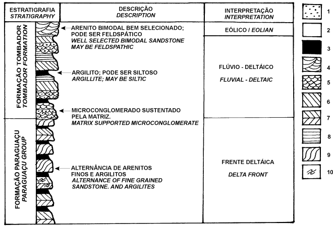
Caption: 1 – Microconglomerate; 2 – Sandstone; 3
– Argillite; 4 to 7 – Cross bedding; 4 – large scale, trough; 5 –
medium to small scale, trough; 6 – tabular; 7 – herring bone; 8 –
Horizontal bedding; 9 – Sigmoids / sandwaves; 10 – Fluidization.
Figure 2 – Graphic sedimentary
log of Pai Inacio Hill (thickness, 150m). Modified from Guimar„es & Pedreira, 1990.
DESCRIPTION OF THE SITE
Taking into account that the Pai InŠcio
Hill is a punctual feature, this paper describes some other surrounding sites that are
geologicaly and geomorphologicaly correlated with it.
Pai InŠcio Hill
Leaving the town of LenÁois towards
Seabra following the BR-242 road, just after the bridge on the MucugÍzinho river, one
sees in the right side of the road, in front of a motel and gas station, the imposing Pai
InŠcio Hill (photo 1). Presently, the access to the hill was eased due to the
construction of a road until close to its summit, that leads to a comunications tower
(Telemar). The road is kept in excelent condition, allowing the ascent and parking of
buses. From the tower to the summit of the hill, the climb is by foot along a well marked
trail, taking about 20 minutes. From the summit, one has a breathtaking view of the
SincorŠ range (photo 2). In the base of the hill winds up the BR-242 road (Salvador
– BrasŪlia), and to the south there is na excellent observation of the Pai InŠcio
Anticline, eroded along its axis (Cercado Valley) and the Morr„o. Northwards is the
Camelo or Calumbi Hill.
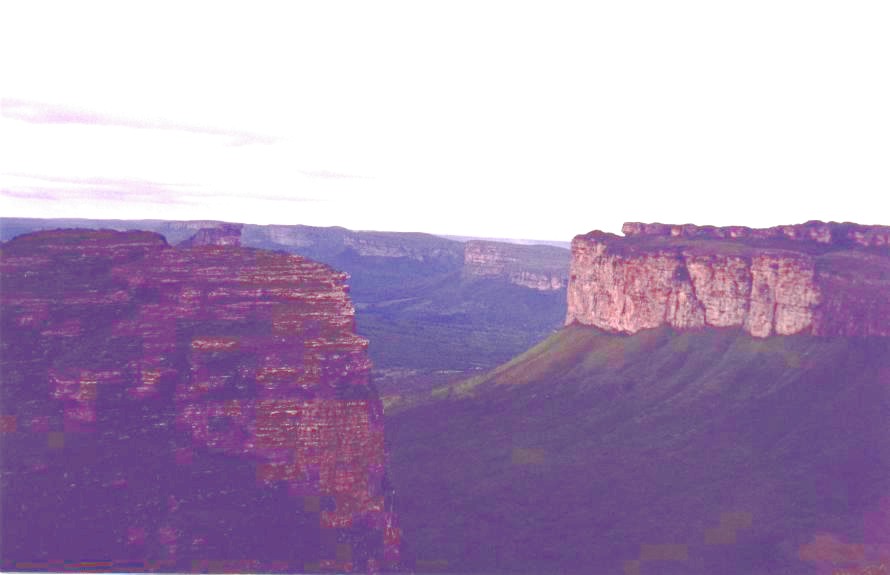
Photo 2 – SincorŠ Range seen
form the summit of Pai InŠcio Hill. Photo by Jo„o Dalton de Souza.
The lower half of Pai InŠcio Hill is
formed by delta front sediments of the upper ParaguaÁu Group, comprising argillites and
siltstones intercalated to tabular cross bedded fine/medium grained sandstones. The upper
half is built by fluvial-deltaic and eolian sediments of the Tombador Formation,
comprising poorly selected, rather feldspatic and pebbly sandstones and well selected
bimodal sandstones.
Funch (1997), reports about the
vegetation of the hill: "Sitting down in the hill summit pay attention to the
surrounding vegetation. Taking advantage of all cracks and sinks on the stones, orchids,
cacti, lichens, mosses and other plants, form a garden on the unhospitable surface of the
rock. One may think about the climatic conditions in the summit of the hill, as a kind of
cold desert. It rains much, but as there is no soil, the water runs off very fast, and the
plants are exposed to the dry wind and hot sun. To depend themselves from these
unfavorable conditions, the plants are adapted to retain and store moisture. The leaves in
general are small, hard and thick, and covered by hairs and waxes, to lessen the water
loss. The Pai InŠcio Hill area is small, with fragile and easily degradation prone
ecosystems, so that it needs a high degree of understanding for its presevation."
Pai InŠcio Anticline
The Pai InŠcio Anticline (photo 3) is a
long erosional window up to 25km wide, that exposes in its inner part sedimentary rocks of
the ParaguaÁu Group, overlain by the sandstones and conglomerates of the Tombador
Formation (figure 3). It is a south plunging asymetric structure, that in Paty valley and
Cap„o regions turns southeastwards plunging and disappearing under the rocks of the
Chapada Diamantina Group.
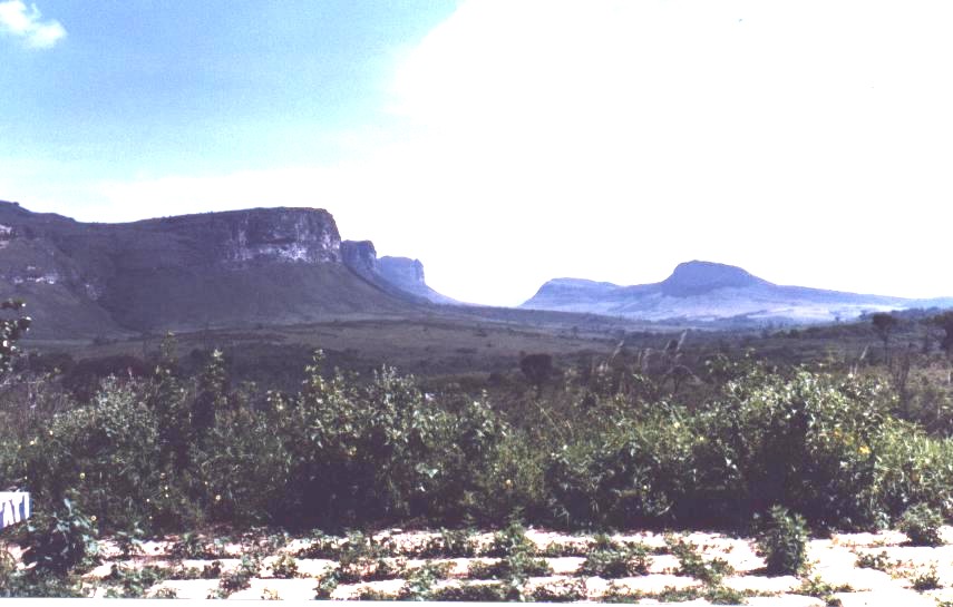 Photo 3 – Pai Inacio Anticline. Photo 100king south.
The axial surface of the anticline dips
steeply to east. The dips in the eastern limb are gentler (5o-15o)
than those of the western one, that may reach 30o.
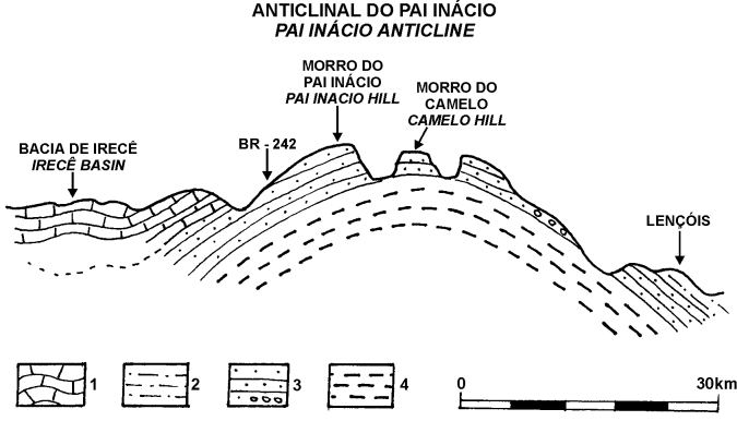
Figure 3 – Location of Pai
InŠcio and Camelo hills in relation to the folds of Chapada Diamantina. Modified from
Kegel, 1959.
Caption: 1 – Una Group; 2 – Caboclo
Formation; 3 – Tombador Formation; 4 – ParaguaÁu Group.
Morr„o
Morr„o is the most beatiful witness of
the regional geologic history (photo 4). Its geology is similar to that of Pai InŠcio
Hill. Posted in the center of Pai InŠcio Anticline, is about 10km south of Pai InŠcio
Hill and is about 210m high (altitude 1.418m).
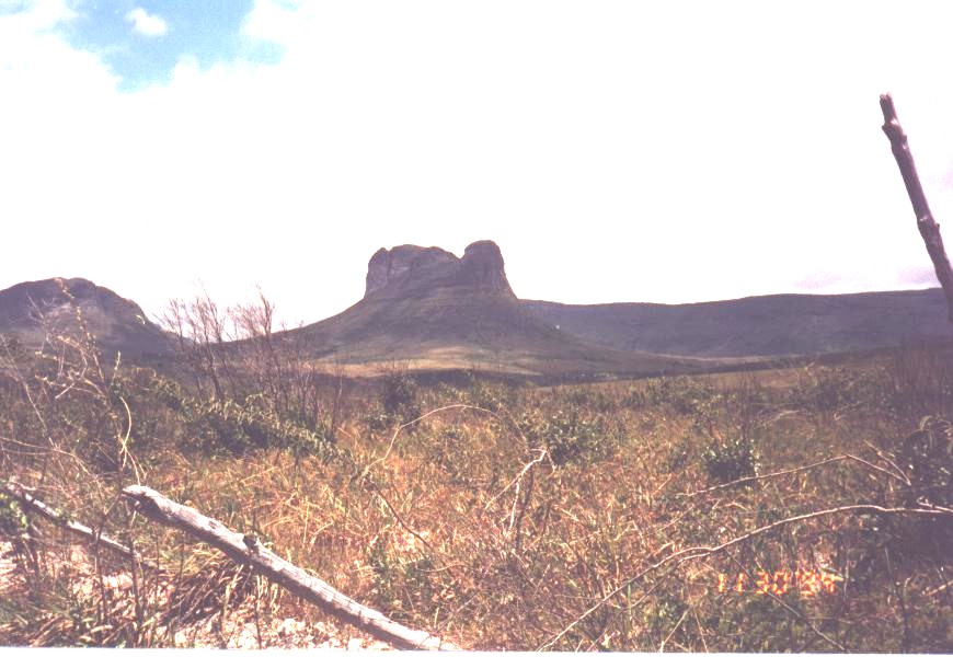
Photo 4 - Morr„o Hill (see location in
figure 1).
Morro do Camelo
Located about 2km north of Pai InŠcio
Hill, the Camelo Hill is about 170m high with an altitude of 1.090. Its geology and
vegetation show little difference from the Pai InŠcio Hill. Observed from the summit of
Pai InŠcio Hill, some people associate the shape of the hill to a woman laying down and
looking oposite from the observer. From another looking point, following along the BR-242
road towards the town of Seabra, it takes the shape of a camel, origin of its name (photo
5). From any direction however, the Camel Hill is always impressive for its grandeur and
beauty.
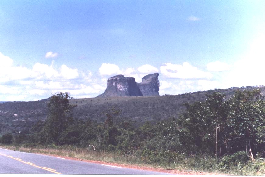
Photo 5 – Camelo Hill (see location
in figure 1).
PROTECTIVE ACTIONS
According to written communication (1999)
from Roy Funch, Director of the Environmental Department of the town of LenÁůis, the Pai
InŠcio Hill is in the "buffer area" of the Chapada Diamantina National Park, so
that it receives a certain legal protection from the IBAMA (Brazilian Institute of the
Environment). This institute deals with actions that could have negative influence on the
park itself. The Pai InŠcio Hill is also within the Marimbus/Iraquara Environmental
Protection Area (State Decree No 2.216 of June 14, 1993), being classified as
"Rigorous Protection Zone", the most restrict of all. Also there is preservation
by the IPHAN (National Institute of the Historic and Artistic Heritage), that poses severe
restrictions on any enterprise in the area.
BIBLIOGRAPHIC REFERENCES
Acau„, B. M. S.; 1987. Relatůrio
dirigido ao governo imperial em 15 de abril de 1847, pelo inspector geral dos terrenos
diamantinos na provŪncia da Bahia. Inst. Hist. Geogr. Ethnogr. Brasil
Rev. Trim, t.9: 227-260.
Bomfim, L. F. C.; Pedreira, A . J.(Orgs)
1990. LenÁůis; folha SD.24-V-A-V.Estado da Bahia. Texto explicativo. BrasŪlia:
DNPM, 130p. (Programa Levantamentos Geolůgicos BŠsicos do Brasil-PLGB).
Bomfim, L. F. C.; Krug, L.; Nolasco, M.
C. 1996. Excurs„o E5: Roteiro GeoturŪstico da Chapada Diamantina.. In: CONGRESSO
BRASILEIRO DE GEOLOGIA, 39 Roteiro de Excurs„o. Salvador: SBG - Nķcleo Bahia -
Sergipe.
Branner, J. C. 1910 The Tombador
Escarpment in the State of Bahia, Brazil. Am. Jour. Sci. 30 : 335-343.
Brito Neves, B. B. de, 1967. Geologia
das Folhas de Upamirim e Morro do Chapťu.Recife, CONESP, 53p. (Relatůrio 17).
Catharino, J. M. 1986. Garimpo-Garimpeiro-Garimpagem.
Rio de Janeiro, Philobiblion, Museu EugÍnio Teixeira Leal. 270p.
Derby, O. A. 1906. The Serra do
EspinhaÁo, Brazil. The Journal of Geology,14 : 314-401.
Funch, R. 1997. Um guia para o
visitante a Chapada Diamantina: o Circuito do Diamante. Salvador: Secretaria da
Cultura e Turismo, 209p.(ColeÁ„o Apoio, 15).
Guimar„es, J. T.; Pedreira, A . J. (
Orgs ). 1990. Utinga; folha SD.24-V-A-II . Estado da Bahia. Texto Explicativo.
BrasŪlia: DNPM, 141 p. (Programa Levantamentos Geolůgicos BŠsicos do Brasil –
PLGB).
Kegel, W. 1959. Estudos Geolůgicos na
Zona Central da Bahia. Rio de Janeiro, DNPM-DGM, 40p. (DNPM-DGM Bol. 198).
Lima, C. C. U. de; Nolasco, M. C. 1997 LenÁůis,
Um Aporte entre a Geologia e o Homem. Feira de Santana: UEFS. 152 p.
Mascarenhas, J. F. 1969. ContribuiÁ„o
ŗ Estratigrafia da Chapada Diamantina na Regi„o entre ItaetÍ e Seabra- Bahia. In:
CONGRESSO BRASILEIRO DE GEOLOGIA 23. Resumo das ComunicaÁűes. Salvador, SBG,
1969. (Boletim Especial, n. 1). p. 59-60.
Pedreira, A . J. & Mascarenhas, J. F.
1974. A SeqŁÍncia EstratigrŠfica da Chapada Diamantina NE, Bahia, Brasil. In: CONGRESSO
BRASILEIRO DE GEOLOGIA 28. Anais. Porto Alegre, SBG, v.4.p.19-26.
Pedreira, A. J. 1994. O Supergrupo
EspinhaÁo na Chapada Diamantina Centro - oriental, Bahia : Sedimentologia, Estratigrafia
e TectŰnica. S„o Paulo, USP – Instituto de GeociÍncias. 126p. (Tese de
doutoramento inťdita).
Pedreira, A. J.; Rocha, A. J. D. 1999. Serra
do Tombador; SŪtios Geolůgicos e Paleontolůgicos do Brasil. http://www.unb.br/ig/sigep/sitio031/sitio031.htm (30
Ago. 99)