
SIGEP
Geological and Paleontological
Sites of Brazil - 098
THE HISTORICAL JARAGUŃ GOLD
EXCAVATIONS
Date: 11/09/2000
Celso Dal Rť Carneiro
cedrec@ige.unicamp.br
Instituto de
GeociÍncias - UNICAMP
Depart. Geociencias Aplicadas ao Ensino - Caixa Postal 6152
13083-970 Campinas SP
Fone: (0xx19) 788-4564 ou 788-4568
Fax: (019) 289-1562 ou 289-1097
© Carneiro,C.D.R. 2000. The historical JaraguŠ gold excavations. In: Schobbenhaus,C.; Campos,D.A.; Queiroz,E.T.; Winge,M.; Berbert-Born,M. (Edit.) SŪtios Geolůgicos e Paleontolůgicos do Brasil.
Published
11/9/2000 on Internet at the address http://www.unb.br/ig/sigep/sitio098/sitio098english.htm [Actually
https://sigep.eco.br/sitio098/sitio098english.htm]
[SEE PRINTED
CHAPTER IN PORTUGUESE]
(The above bibliographic reference of author copy rights is required for any use of this article in any media, being forbidden the use for any commercial purpose) |
ABSTRACT
The scarcity of specific studies on the ancient gold excavations of
JaraguŠ - or the vestiges that still remain - is as noticeable as its historical
importance. A public preservation of such an area of "relevant historical
heritage" is justified for the fact that they were pioneer in the Province by end of
the XVI century. The open-sky ruins were considered ancient, by 1822, by the mineralogist
Josť BonifŠcio de Andrada e Silva. Also known as the "Morro Doce gold caves",
they are sinuous in maps, in a narrow zone between metasediments and metavolcanics of the
S„o Roque group. This Upper Proterozoic unit disapears westwards, below the sediments of
the ParanŠ basin. The site is important for mining studies, but the main cave, marginal
to the AnhangŁera road, is covered by bush, soil, garbage and waste. The limits of the
area of interest should be located first The construction of a small park would be
valuable, but it must be accompanied by a effort to improve the awareness of the local
population on the historical importance of the site. This is the unique way to stop the
continuous accumulation of garbage and waste, for the benefit of future visitors and
scholars.
INTRODUCTION
The scarcity of available information on the ancient gold excavations
of JaraguŠ has no parallel with its importance. The principal objective of this notice is
to recover some unpublished data on them, due to the lacking of specific studies. We
justify the preservation of such an area by the State as a testimony of "relevant
historical heritage". Among the countless vestiges of ancient mining of metallic
substances in the Precambrian part of the S„o Paulo State, those at JaraguŠ, also known
the "Morro Doce gold caves", have a singular geographical distribution, linked
to the folded structures and local lithological associations.
During the XVI century the pioneer JaraguŠ caves were the closest
mines to the capital of S„o Paulo. The scientific interest of the geologic site may be
evaluated not only from the historical aspects, but from many mining prospects which
spread, during the last decades, in the occurrence area of the S„o Roque Group, between
Morro Doce and Santana do ParnaŪba, situated westwards. The mining requests to the DNPM
indicate that the area still plays some interest for mining in spite of the fact that the
mineral prospecting may be temporarily interrupted.
The disheartened scenery of the ancient caves is due to the urban
occupation of the region of the Morro Doce Park as well as other popular land parcels,
that fast adjoining that area, under the capital's economic influence (Carneiro 1996). If
the mineral vocation of the S„o Paulo territory can be evaluated by the known
occurrences, the Morro Doce caves allow an incomparable deep incursion into the Brazilian
colonial past. During the XVI century gold was mined there (Abreu 1973). The gradual
exhaustion of them and the noticeable discoveries in Minas Gerais dislocated the interest
focus of Portuguese to the latter region.
SITUATION
The ancient JaraguŠ gold caves are situated on the Atlantic Plateau by
the Capricorn Tropic (Fig. 1), more precisely at the coordinates 23ļ 26Ę S and 46ļ 47Ę WG. They are composed
by a series of excavations following the N50ļW direction (Fig. 2): they are sinuous and
discontinuous in maps; the principal cave is also the closest to the AnhangŁera road
(Fig. 3).
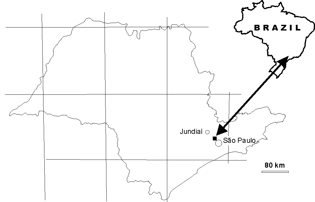
FIGURE 1 - Situation map of the Morro Doce area
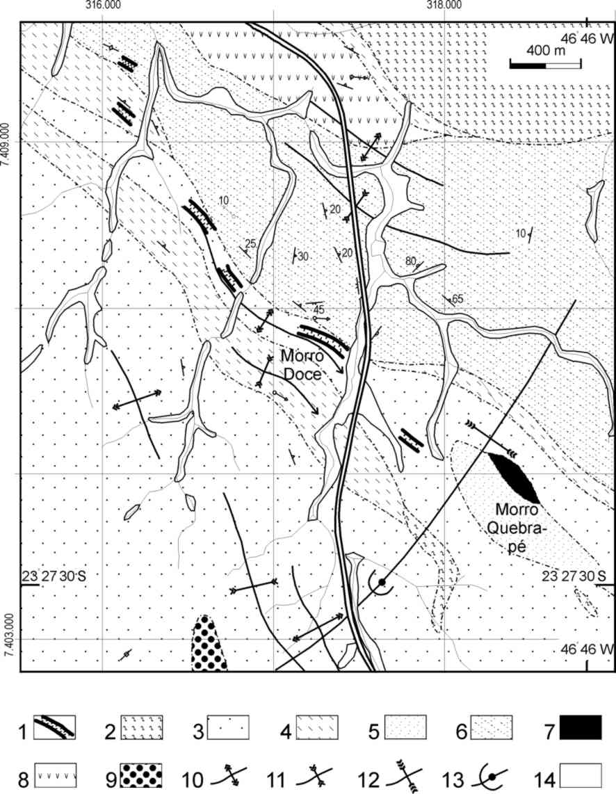
Figure 2 Ė Geological
map with the distribution of vestiges
of ancient caves and probable complementary mineral prospection works. Symbols:
1 - Excavations; 2 to 9 - Lithological units: 2 - schist, 3 - metarenite, 4 -
red phyllite, 5 - quartzite, 6 - calcium-silicate rock, 7 - Amphibolite, 8 - Banded
amphibolite and metatuff, 9 -
Metaconglomerate, 10 Ė Antiform F2,
11 Ė Sinform F2, 12 Ė Sinform F3, 13 Ė Neutral fold F3,
14 - Quaternary alluvium (Sources: Carneiro,1983;
IPT,1981).
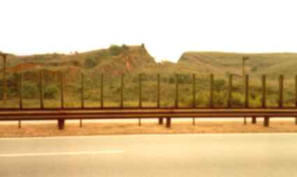
FIGURE 3 - Ancient gold cave of Morro Doce, a photograph dated
1981 (Foto CDRC)
The easiest access to reach the area of the ancient caves from S„o
Paulo is the AnhangŁera road. After the access to the JaraguŠ Peak at the 16,5 km, the
caves are by the left, between the km 23 and 24, at the end of a long descent, after a
road sign indicating the position of the Capricorn tropic line, it may be observed the
Morro Doce excavation. Many houses nowadays round the "V" -shaped scar in the
slope. People who live there surely ignore its nature and meaning.
HISTORY
Theodoro Knecht, a researcher on the S„o Paulo ores, published in 1951
a photograph of the main excavation, from the same view that we can see today by the
AnhangŁera road. He described these features as "ancient gold caves", but the
expression does not belong to him as well. The mineralogist Josť BonifŠcio de Andrada
and Silva considered the open-sky cave ruins ancient, in 1822, in a visit to the S„o
Paulo Province. In the S„o Vicente Capitany, these pioneer extractions have announced our
mining vocation - at the end of the XVI century - by the same time of those of ParanaguŠ. More than 400 years ago
under the command of Afonso Sardinha and his brother, many people worked there.
DESCRIPTION OF THE SITE
Geographic aspects
Each one of the caves has steep to subvertical walls, without
vegetation and covered by loose material from the slopes. Urban occupation currently
dominates the region of the gold caves. The land transformation is fast: during the last
four decades the urbanization has replaced small farms and properties of the rural zone.
The belt the excavations belong to is oriented along the WNW direction for approximately
6-km, with no more than 800 m wide. In the non-occupied areas the remaining vegetation is
mainly of eucalypti and some poorly defined rests of native forest.
The main cave is presently covered by bush, soil, garbage and
construction waste (Fig. 4). At the margin of the AnhangŁera road, there also two narrow
galleries in the decomposed phyllite, partially filled by soil at a road cut close to an
abandoned gas station (Fig. 5). The upper abobades are
curved, as small chapels and similar to other ones found in the Embu and Guarulhos
regions. They were opened for mineral discovery and evaluation of new gold veins. Two
cemeteries near this place would surely be threatened if a new gold run were started.
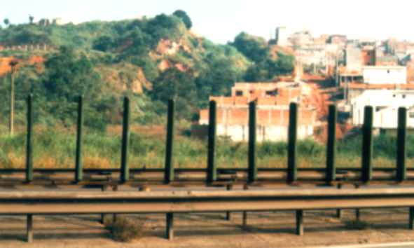
FIGURE 4 - The same gold cave, photograph dated april, 1996.
The area became more threatened by the urban growth (Photo CDRC)
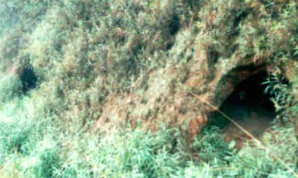
FIGURE 5 - Two narrow galleries for mineral prospection,
almost filled by soil. The height is approximately 1,2 m (Photo CDRC)
Regional geology
The complex folding of the rock units (Carneiro et al. 1985) controls,
at the JaraguŠ region, the tenths of registered mineral occurrences (IPT 1981). The
described belt is situated at the transition zone of a domain of impure metapsamitic
rocks, interbeded with metapelitic members, to a domain of metacarbonate rocks containing
countless belts of metatuffs and metavolcanic rocks. Among the impure metapsamitic rocks
there are sandstones, arkoses, graywackes, quartz phyllites and subordinate polymitic
conglomerates and pure white quartzites, as in the Quebra-Pť hill and at the JaraguŠ
peak. Red phyllites exhibiting of differentiated banding (Carneiro 1983) and rare fine
schists constitute the metapelitic rocks. At the outcrops, the metacarbonatic rocks are
found completely decomposed, except by the east, at Perus region, where some pegmatite and
tourmaline granite have exposed horizons of fresh carbonate rock. The metatuffs are
usually green rich in tremolite-actinolite, oligoclase, some biotite and opaques. There
are also secondary minerals, as epidote, formed by the decomposition of mafic minerals.
The differentiated banding is the more conspicuous feature among the
folded planar features. Neutral vertical folds showing NNE-trending axial planes determine
the sinuous pattern of the preceding structures, mainly those with the differentiated
banding as the axial-plane foliation. The open-sky caves obey to this control, being
limited, in maps, in a narrow zone of red-purple phyllites.
In the NE side of the main cave it was observed in 1982 a gallery for
mineral prospecting, NNE trending. At the end of it there was a vertical shaft of unknown
depth. These features disappeared a few years ago, due to the accumulation of soil and
construction waste. At the extension of the main cave, to the right side of the road,
under eucalyptus, it was recovered a sample of quartz vein which indicated 20 ppm of gold,
at the extremity of a cave close to one of the abovementioned cemeteries. Under the
electron microscope, the sample indicated presence of free gold dispersed in small
concentrations of limonite, suggesting its liberation from weathering processes that
affected gold-bearing pyrite, liberation of submicroscopic gold and accretion of gold over
crystallization nuclei, generating visible particles (IPT 1982). Samples of primary gold
were not recovered.
There is no reliable data on when the mines were exhausted, but it is
evident that Portuguese men used reasonable criteria for mineral prospecting: the probable
prospecting galleries (Fig. 5) are perpendicular to the general direction of the foliation
and local structures. The rudimentary washing and purification did not reach the deepest
material, for the fact that it would require better techniques for ore location and
evaluation. The poor knowledge of the mineralizations and on the local complex geology
seems to be determinant factor of the insuccess of the mineral prospecting, even in more
recent times.
SITE PROTECTION
The abandonment of the ancient JaraguŠ gold caves is deplorable. After
its disappearance, traces of a mineral exploration history will be lost; the history has
started approximately four hundred years ago... S„o Paulo needs open-sky museums, but for
the Morro Doce caves it can be too late. There is, for sure, a small Indian village, far
from there, close to the JaraguŠ peak. It is considered as the smallest Indian reserve of
Brazil, occupied by an Indian remaining family, which control the visitor's access to a
precarious "gold tank", that operated during the colonial times. Nevertheless,
without a movement from the geological community, the above described picture of the Morro
Doce region will never be reverted because the time factor does not help us: we will
depend on several changes and, mainly, on the improbable political decision from the
govern.
A maxim priority would be given to the accurate location of the limits
of the area of interest. The sketch presented on figure 2 is based on field surveys and
airphoto interpretation, being reasonably precise, but the data is from 1981-82. After
this it should be started the work for improving the awareness of the local population on
the historical importance of the site, to interrupt the continuous accumulation of garbage
and waste. The proposal of construction of a small park there would be valuable, but it
should be linked to a process to preserve the area by the public departments responsible
for that.
The area will not resist to one more decade of abandon. The contrast is
absolute with the beautiful natural parks of Salto and Itu (see CiÍncia Hoje, n.
112, p. 24-31, 1995). Without memory, there is no history, as these brilliant examples do
demonstrate. The urban growth will vanish these testimony from the past. By one side of
the AnhangŁera road, they are faced by cemeteries; by the other side, by the city and its
waste, that soon will clean out the sinuous way from the map, if nothing is done to stop
the non-planned "urbanization".
References
ABREU, S.F.de. Recursos Minerais do Brasil. 2 ed.
S„o Paulo: Nacional. 222p. 1975. v. 1.
CARNEIRO, C.D.R. 1983. AnŠlise estrutural do Grupo S„o Roque na
faixa entre o Pico do JaraguŠ e a Serra dos Cristais, SP. S„o Paulo. 155p.
(Doctorate thesis, Inst. Geoc. USP).
CARNEIRO, C.D.R. 1996. As cavas antigas de ouro do JaraguŠ. CiÍncia
Hoje, v. 21, n. 125, p. 22. (CrŰnica).
CARNEIRO, C.D.R.; HASUI, Y.; NAGATA, N.; LIMA, M.O. de. 1985. Padrűes
de superposiÁ„o de estruturas do Grupo S„o Roque na faixa JaraguŠ-Cristais (SP). Rev.
Bras. Geoc., v. 15, n. 2, p. 116-130.
INSTITUTO DE PESQUISAS TECNOL”GICAS DO ESTADO DE S√O PAULO (IPT). Mapa
de jazidas e ocorrÍncias minerais do Estado de S„o Paulo. S„o Paulo: IPT. 1981.
758p. (IPT. Monograph 4, Publication 1171)
INSTITUTO DE PESQUISAS TECNOL”GICAS DO ESTADO DE S√O PAULO (IPT). CaracterizaÁ„o
mineralůgico-quŪmica e petrogrŠfica, por microscopia ůptica, microssonda eletrŰnica e
microscopia eletrŰnica de varredura, de uma amostra de rocha procedente da regi„o do
Morro Doce-SP. S„o Paulo: IPT. 1982. 10p. (IPT. Report 16 563)
KNECHT, T. 1950. OcorrÍncias minerais do Estado de S„o Paulo. S„o
Paulo: Secretaria da Agricultura. 144p. (v. 1: municŪpios de S„o Paulo, Santana de
ParnaŪba, Barueri, Franco da Rocha, Guarulhos, Mogi das Cruzes, Suzano e PoŠ).