
SIGEP
Geological and
Paleontological Sites of Brazil - 094
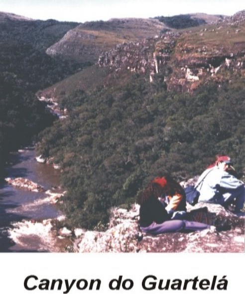
GUARTELÁ CANYON
Date:22/01/2000
Mário Sérgio de Melo
msmelo@uepg.br
UEPG - Praça Santos Andrade s/n - CEP
84010-970 - Ponta Grossa, PR
© Melo,m.s. 2000. Guartelá Canyon. In: Schobbenhaus,C.; Campos,D.A.; Queiroz,E.T.; Winge,M.; Berbert-Born,M. (Edit.) Sítios Geológicos e Paleontológicos do Brasil. Published
22/1/2000 on Internet at the address http://www.unb.br/ig/sigep/sitio094/sitio094english.htm [Actually
https://sigep.eco.br/sitio094/sitio094english.htm]
[SEE
PRINTED CHAPTER IN PORTUGUESE] (The above bibliographic reference of author copy rights is required for any use of this article in any media, being forbidden the use for any commercial purpose)
|
Abstract
The Guartelá Canyon is a rectilinear gorge with an extension of
approximately 30 km and a maximum depth of 450 meters. It was carved out by the River
Iapó, which uses the canyon to overcome the Devonian Escarpment, a cuesta that separates
the First and Second Paraná Plateaux. The River Iapó is a right bank affluent of the
River Tibagi, which flows into the Paranapanema River, part of the Paraná River basin.
The Iapó is an impressive example of an antecedent river, which has its source on the
First Paraná Plateau to the east, breaks the Devonian Escarpment via the Guartelá
Canyon, and advances to the west-northwest. The Canyon is controlled by long ruptile
structures (faults, fractures), sometimes with intrusive diabase dykes and related rocks,
in a NW-SE direction, connected to the Ponta Grossa Arch, reactivated in the Mesozoic
period. The Guartelá Canyon escarpments are supported by the Furnas Sandstone (Devonian
of the Paraná Basin), whose excellent exposure enables it to be subdivided into three
sub-units with distinctive characteristics. Under the Furnas Sandstone, the Iapó
Formation (Silurian, basal unit of the Paraná Basin region) and the Castro Group
(volcano-sedimentary sequence of the Ordovician period) appear. The River Iapó flows over
these rocks, forming many waterfalls and stretches of white water. The Furnas Sandstone
presents considerable differential erosion, controlled by the change in rock attributes,
sedimentary and ruptile structures, causing a bizarre ruiniform relief. Caves formed by
the Castro Group (Gruta da Pedra Ume) and many caves of the Furnas Sandstone forming
natural shelters where cave paintings, lithic artefacts and ceramic remains of
paleoindians are found, occur in this region. As well as this, the poor, shallow soil of
the Furnas Sandstone and the cuesta relief barrier have favoured the preservation of
remains of scrubland (savanna), a form of vegetation formerly widespread in the region.
Location
The Canyon of Guartelá is situated in the centre-east region of the
State of Paraná (Fig. 1), extending for approximately 30 km between the municipalities of
Castro and Tibagi, with the centre located on the coordinates 24°
32´S and 50° 17´W.
The State Park of Guartelá is situated in the central portion of the
Canyon. It is located approximately 203 km northwest of Curitiba, and is reached by
following the BR-376 highway as far as Ponta Grossa (115 km), then the PR-151 to Castro
(45 km), and finally the PR-340 (Castro-Tibagi) for 42 km until the park entrance is
reached.
The canyon is approximately rectilinear, controlled by geological
structures (fractures, faults, dykes) in a NW-SE direction. It marks the breaching of the
Devonian Escarpment by the River Iapó, which comes from the First Paraná Plateau to the
southeast, and cuts through the escarpment in a long, deep gorge to reach the Second
Plateau, to the Northeast.
The top of the Devonian Escarpment, a typical cuesta relief only
locally controlled by ruptile structures, corresponds to the region of the Campos Gerais
of Paraná (Fig. 1), a phytogeographic zone marked by the presence of shallow soil with
low fertility derived from sandstone, with a vegetation of open grassland (MAACK 1948).
History
Before European colonisation, the region of the River Iapó canyon was
inhabited by the caingang Indians, a branch of the Tupi-Guarani nation (LANGE 1994). The
many remains left by the passage of the Indians through the region indicate they were
groups of nomadic hunter-gatherers (CHMYZ 1976, PROUS 1992, SCHIMITZ 1997, SILVA 1999),
who moved about in search of food or following the old Peabirú trail between the coast
and the interior or vice-versa.
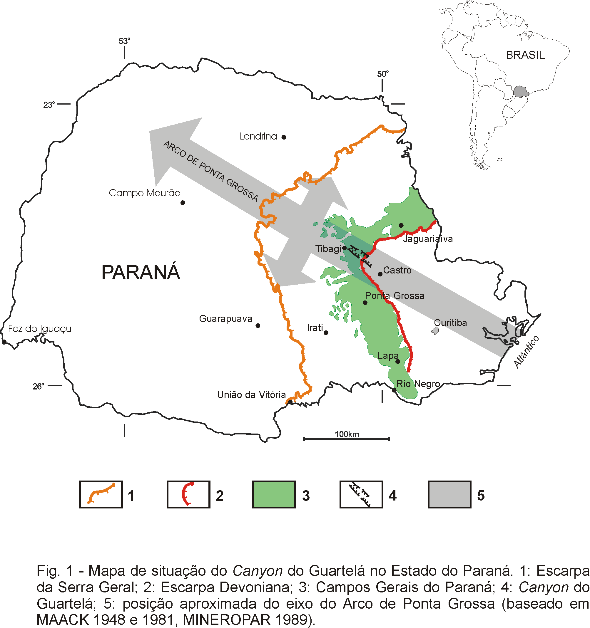
Fig. 1 - Location of the Guartelá Canyon in the State of
Paraná. 1: Serra Geral Escarpment; 2: Devonian Escarpment; 3: Campos Gerais Region; 4:
Guartelá Canyon; 5: approximate position of the axis of the Ponta Grossa Arch (based on
MAACK 1948 and 1981, MINEROPAR 1989).
From the 18th century onwards, with the movement of mule
caravans and cattle from the state of Rio Grande do Sul to the markets in the states of
Săo Paulo and Minas Gerais, the grasslands of the Campos Gerais became very sought after.
At that time, the Portuguese throne began issuing property letters to men with local
political prestige. In 1725 the land between the Iapó and Pitangui rivers, including the
site corresponding to Guartelá today, was delegated to José de Góes Moraes, Bartolomeu
Paes de Abreu e Antonio Pinto Guedes (LANGE 1994). The period of the mule caravans, which
lasted until the beginning of the 20th century, still has a great influence on
the culture and customs of the Campos Gerais of Paraná and the Guartelá region, whose
population retains many habits inherited from the mule-drivers, mostly of Gaúcho origin.
In his travels through the south of Brazil at the beginning of 1820,
SAINT-HILAIRE (1978) referred to a "farm called Guartelá" located near the
mouth of the River Iapó, proving that the name was already being used in those days. The
most widely accepted version of the origin of the name "Guartelá" is that an
inhabitant of the region tried to protect a neighbour from the imminent attack of the
caingang Indians by giving the warning "Guarda-te lá que aqui bem fico", from
which the word Guartelá is derived (LANGE 1994).
More recently, Guartelá has become a region of smallholdings, where an
extensive cattle raising is the principal means of subsistence. In the last decades the
canyon has received an increasing number of visitors keen on ecological activities, which
led the Government of the State of Paraná to establish the State Park of Guartelá, by
Decree n° . 1229 of 27/03/92, which had as its aims: a) to
guarantee the preservation of local ecosystems, sites of exceptional scenic beauty, such
as canyons and waterfalls, as well as important speleological, archaeological and
pre-historic sites, especially cave paintings; b) the conservation of the Araucária
forest; c) preservation of springs; d) protection of the native fauna and flora; e)
regulation of tourism in areas potentially suitable for visiting; f) preservation of
archaeological sites (DIEDRICHS 1995, ROCHA 1997).
The park was only properly established in the spring of 1997, with an
area of 789.9 ha on the left bank of the River Iapó. Administrated by the IAP
(Environmental Institute of Paraná), the park has a reception area for visitors, a
campsite, facilities for research, and sign posted trails. The Ecological Reserve of
Itaytyba, created in 1997 with 1,090 ha, is being set up on the right bank of the River
Iapó as a ‘natural private patrimony reserve’ (RPPN), on privately owned land
(MACHADO 1999).
Description of the Site
The Guartelá Canyon is a unique site, because of its impressive and
diversified features: remarkable geomorphology, with gorges and rocky escarpments,
ruiniform relief, waterfalls and rocky-floor creeks; exceptional Furnas Sandstone
exposure, allowing a detailed faciology and subdividing it stratigraphically; close relief
control by ruptile structures linked to the Ponta Grossa Arch; existence of caves, some
with archaeological material; coexistence of various ecosystems (grasslands, savanna,
araucaria forest), that reflect the different paleoclimatic conditions, with native
species of fauna and flora that are in danger of extinction outside preservation areas.
Relief
The Guartelá is a breach of the Devonian Escarpment, a cuesta relief,
by the River Iapó, an antecedent river which must have originated in the Jurassic period,
at the time of the last great uplift of the Ponta Grossa Arch (Fig. 2). The canyon is one
more important feature in the relief of the State of Paraná resulting from the
reactivation of this upward movement in the Mesozoic. The others are escalating erosive
plateaux, the Devonian Escarpment and the dyke swarms that support long crests in the
NW-SE direction, parallel to the arch axis.
The River Iapó has its sources on the First Paraná Plateau, east of
Guartelá. Before flowing into the canyon, the river meanders across an extensive
floodplain with vast alluvial deposits, above which Castro is situated. The name Iapó
came from this characteristic, in the indigenous language meaning " the river that
floods" (LANGE 1994).
The drainage pattern in the region of the Guartelá Canyon is clearly
rectangular with the longer rectilinear stretches going NW-SE. The canyon is, in fact, a
succession of main rectilinear stretches in a NW-SE direction, linked by shorter stretches
lying NE-SW (Fig. 3).
The bed of the River Iapó near Castro, upstream from the Canyon, is
approximately 980 m above sea level, whereas near Tibagi, the lowest point of the canyon,
it is 760 m above sea level. The highest point of the Devonian Escarpment near Guartelá
is 1,279 m. In the State Park region the altitudes difference between the riverbed and the
top of the escarpment is 400 m.
The ruptile structures (faults, fractures and associated dykes), the
different lithotypes of the Furnas Sandstone, as well as the sedimentary structures
(planar and cross-bedding stratifications) contribute to the bizarre formations sculptured
by weathering agents (Figs. 4 and 5), giving rise to characteristic ruiniform relief
(AB´SÁBER 1977, MELO & COIMBRA 1996). Rainwater infiltrating the sandstones through
fractures and from the stratifications causes alveolar erosion and anastomosing tunnels
(FORTES 1996, MELO & COIMBRA 1996), which combine the dissolution of the kaolinic
cement and the mechanical removal of grains, forming excavations that contribute to the
bizarre rock formations (Fig. 6).
A common feature of the sandstone plateau is the enclosed waterlogged
depressions, that frequently form small lakes (Fig. 3). One example is the Bonita Lake,
which has already been studied for the paleoclimatic reconstitution of the region (BEHLING
1997a and 1997b). It is possible that these depressions are a result of underground
removal, chemical as well as mechanical, of the material of the Furnas Sandstone (kaolinic
cement and quartz grains). This removal is caused by the infiltration of water, especially
along the structural directions that favour the permeability of the rock massif.
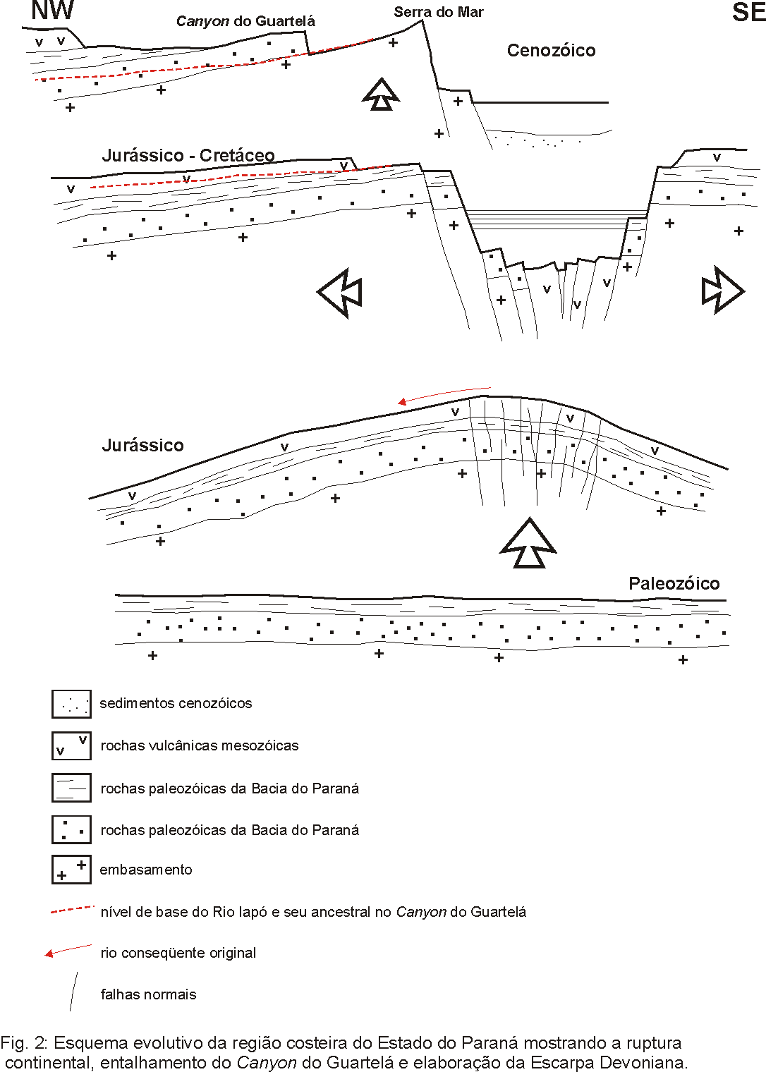
Fig. 2 - Evolution sketch of the coastal region of the State of
Paraná in Southern Brazil, showing continental break-up and formation of the Guartelá
Canyon and Devonian Escarpment.
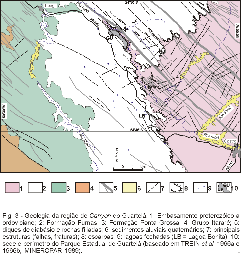
Fig. 3 - Geology of the region of the Guartelá Canyon. 1:
Proterozoic to Ordovician basement; 2: Furnas Formation; 3: Ponta Grossa Formation; 4:
Itararé Group; 5: dykes of diabase and associated rocks (Mesozoic); 6: Quaternary
alluvial sediments; 7: main structures (faults, fractures); 8: escarpments; 9: small
enclosed lakes (LB = Bonita Lake); 10: reception centre and perimeter of the State Park of
Guartelá (based on TREIN et al. 1966a and 1966b, MINEROPAR 1989).
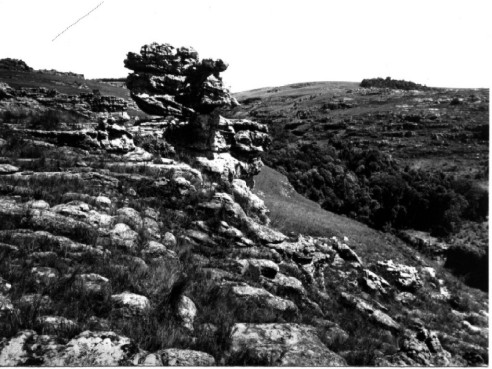
Fig. 4 - Ruiniform relief in the Furnas Sandstone with forms controlled
by sedimentary and ruptile structures. Note dominating grasslands with copses and gallery
woods.
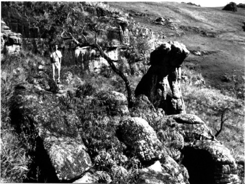
Fig. 5 - Ruiniform relief in the Furnas Sandstone, with polygonal
fractures in the rock surface. Note some typical savanna trees and dominating grassland.
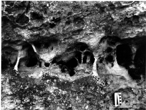
Fig. 6 - Alveolar erosion and anastomosing tunnels, these latter
controlled by preexisting structures of the Furnas Sandstone in the escarpments of the
Guartelá Canyon.
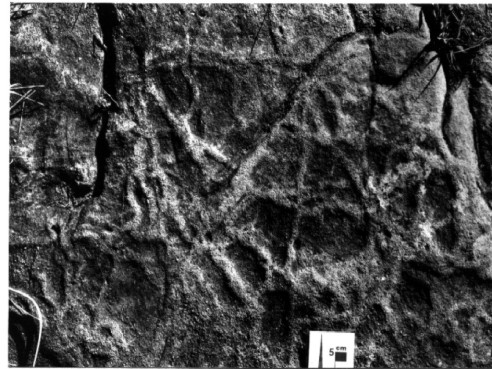
Fig. 7 - Fossil tracks (Paleophycus) parallel to the Furnas
Sandstone bedding near the Ponte de Pedra waterfall.
Stratigraphy
The Devonian Escarpment is a cuesta relief that marks the beginning of
the occurrence of the units of the east border of the Paraná Basin over its basement. It
is so called because it is supported by the Furnas Sandstone, from the Devonian Period,
which is why it would be more appropriate to call it the "Devonian Sandstone
Escarpment", as the escarpment is far more recent, occurring after the reactivation
of the Ponta Grossa Arch in the Mesozoic.
The rocks that appear in the basement of the Paraná Basin in the
Guartelá Canyon region are part of the Castro Group (Ordovician), comprising volcanic
(rhyolites, andesites), pyroclastic (tuffs, lapilli) and terrigenous (conglomerates,
arkoses, siltstones, mudstones) rocks with associated volcanic breccia, tectonically very
deformed and frequently verticalized. They occur on the Iapó riverbed for a long stretch
along the canyon.
The Basal unit of the Paraná Basin in the region is represented by the
Iapó Formation (Ordovician/Silurian limit), included in the Ivaí River Group. It
comprises subglacial diamictites, with a thickness of less than 20m (ASSINE et al.
1998). The occurrence of this unit is not continuous, which is why it appears, for
example, at the beginning of the Devonian Escarpment along the PR-340 highway, and fails
to appear in various places along the canyon.
The Furnas Formation, or Furnas Sandstone (Lower Devonian), appears
with a discordant contact over the Iapó Formation. The sandstone has a maximum thickness
of between 250 and 300 metres in the region (MAACK 1970, ASSINE 1996). It shows a gradual
transition to the basal strata of the overlying Ponta Grossa Formation, with which it
composes the Paraná Group.
The Furnas Formation is composed predominantly of medium and coarse
sandstones with light colouring, relatively homogeneous, feldspathic and/or kaolinic in
its basal portion, with angular and subangular grains. The typical light colouring is due
to the presence of kaolinite and illite as matrix/cement of the grains of quartz and
feldspar (RAMOS & FORMOSO 1975). The kaolinite shows a detritic as well as authigenic
aspect (MELO 1999, MELO et al. 1999), while the illite seems to be predominantly
authigenic (MELO 1999).
Especially in the basal portion there occur metrical interbedded layers
of conglomerates and conglomeratic quartzous sandstones. Towards the top, metric layers of
fine sandstones and argillaceous siltstone appear, the latter occurring with more and more
frequency, characterizing the gradual transition to the sediments of the Ponta Grossa
Formation (LANGE & PETRI 1967). These faciological variations, very clear on the
outcrops on the escarpments of the Guartelá Canyon, led ASSINE (1996) to propose a
subdivision of the Furnas Formation into three faciological associations corresponding to
the hierarchy of members, besides the "transition layers" as it changes to the
overlying Ponta Grossa Formation. These are:
Unit 1 (lower): consisting of medium and very coarse sandstones
interbedded with conglomeratic sandstones and quartz conglomerates, arranged in tabular
and lenticular sets, with a thickness of 0.5m to 1.5 m, with tabular and tangential
cross-bedding stratification; basal conglomerates occur (up to 2 m thick) with rounded
quartz clasts of up to 12 cm; maximum thickness of this unit in the canyon is 30 m.
Unit II (medium): predominantly medium sandstones in tabular to
cuneiform sets 0.5 to 2.0 m thick with tabular and tangential cross-bedding
stratification, which can merge laterally into siltstones or whitish-greenish shales where
evidence of wave activity may appear; fossil tracks parallel to the surface of the layers
are common (Paleophycus, Fig. 7); this unit reaches a thickness of 120 m in the
canyon;
Unit III (upper): medium to very coarse sandstones in sets of up to 5.0
m in thickness with tabular and trough cross-bedding stratification; presence of lag
deposits up to 0.5 m thick, containing rounded gravels of quartz and quartzite of up to 15
cm; the maximum thickness of this unit in the canyon is 120 m.
The palaeoenvironment of the Furnas Formation has been the subject of
many debates. Sometimes it is interpreted as continental to transitional (ASSINE et al.
1994, MILANI 1997, MILANI et al s.d.), sometimes as marine (ASSINE 1996). The
transition to the sediments of the overlying Ponta Grossa Formation shows an indisputable
marine transgression at the top of the Furnas Formation.
The most recent rocks present in the Guartelá Canyon region are
attributable to the Serra Geral Formation (Upper Jurassic to Lower Cretaceous). They are
represented by many dykes, predominantly of diabase, but also including microdiorite,
quartz-microdiorite and porphyry microdiorite (TREIN et al. 1996a)
The dykes appear in the form of tabular parallel-verticalized bodies
lying NW-SE, longitudinal to the axis of the Ponta Grossa Arch. They can be up to 200 m in
thickness and more than 20 km in length. Up to 20 dykes can occur in a stretch of 4 km in
width (Fig. 3), making it one of the most noticeable examples of dyke swarms in Brazil.
Geological Structures
The Guartelá Canyon is situated on the axis of the Ponta Grossa Arch,
an important NW-SE structure of the Paraná Basin. It is an arch in the form of a
structural high with the axis inclined to the NW, active since the Palaeozoic, but the
scene of intense tectonic activity especially during the Mesozoic. The vertical movements
along the arch reached their peak during this time, when deep longitudinal fractures gave
way to the magma which formed the extensive lava flows of the Serra Geral Formation, which
appear on the Third Paraná Plateau, in the west of the state. The Ponta Grossa Arch is
considered to have been an aborted triple junction branch during the fragmentation of
Gondwana and the origin of the South Atlantic (HERZ 1997).
The Ponta Grossa Arch is responsible for some of the more notable
geological and geomorphologic features of the east flank of the Paraná Basin:
a) fractures, faults and dyke swarms, predominantly of diabase, in a
NW-SE direction, which control local relief and hydrography;
b) concavity of the contact of the Palaeozoic sediments of the Paraná
Basin over its basement, and exposure of lower units (Furnas and Ponta Grossa formations)
which do not outcrop in many areas of the basin; this re-entrance corresponds to the
erosive removal of the Palaeozoic sediments in the higher parts of the arch;
c) scaling of the relief on plateaux of erosive origin in the State of
Paraná, a result of the combination of the effect of the tectonic raising in the Ponta
Grossa Arch with the differential erosion acting on the rocks of the Paraná Basin and
Proterozoic and Ordovician basement.
In the stretch of the Canyon between Castro and Tibagi, the Iapó River
is strongly controlled by the NW-SE ruptile structures, longitudinal to the axis of the
Ponta Grossa Arch. They contain the main rectilinear stretches of the river, which are
linked by secondary structures, transversal to the former (Fig. 3). These latter, without
dykes, many times displace the dykes, suggesting that these transversal structures are
younger.
Ecosystems and Palaeoclimatology
Open grasslands of the savanna type (TAKEDA et al. 1996, MORO
1998), which occupy most of the peaks and flanks of the hills, predominate in the
Guartelá Canyon and neighbouring regions (Figs. 4, 5 and 8). The uniform physiognomy of
the fields is only broken up by the occurrence of Araucaria forest, which appears in the
form of gallery woods (frequently found at the bottom of canyon-type valleys) or in
isolated copses (Fig. 4 and 8). This type of forest formation is included in the
phytoecological zone of the mixed ombrophyla forest (VELOSO & GÓES FILHO 1982)
situated in Maack’s so-called "region of open grasslands with copses and gallery
woods along rivers and creeks (also Araucaria zones)" (MAACK 1981).
The vegetation of the grasslands consists mainly of grasses Cyperaceae,
Compositae, Verbenaceae and Leguminosae, which form a dense herbaceous covering (TAKEDA et
al. 1996, MORO 1998).
In the copses various stages of succession can be distinguished. In the
pioneer nucleus heliophila species of the Myrtaceae, Anacardiaceae and Euphorbiaceae
families predominate, without Araucaria. In the more developed nuclei "...the Araucaria
is found surrounded by an undergrowth of Myrtaceae and Lauraceae, on the edge of which
Melastomataceae and Compositae occur in abundance" (MORO 1998, p.14).
Apart from the vegetation that appears in the more developed areas
described above, Palmae, bamboos and pteridophytes (ferns) also occur in the vegetation
along the edges of rivers and bodies of water, as in the case of the Iapó River in the
canyon. Angico (Leguminosae) also appears in the more developed stages of the gallery
woods, which can be observed along the Iapó River.
In Guartelá there is an enclave with a phytoecological formation
typical of open wooded savanna (TAKEDA et al. 1996), with some indicative plant
families, such as Vochysiaceae, Ochnaceae (Fig. 9) and Caryocaraceae. The enclave is
thought to be a relict of the semi-arid vegetation that may have covered the State of
Paraná in a past age (MAACK 1949, KLEIN 1984), still surviving in places along the Cinzas
River (Jaguariaíva and Sengés), Sabáudia, Campo Mourăo and Guartelá, this being the
southernmost example in Brazil. In Londrina (north of the State of Paraná) the analysis
of carbon isotopes in soils of the semi-deciduous mesophytic forest revealed that between
5450 and 9340 years BP this scrubland dominated the landscape (PESSENDA et al.
1996).
The preservation of these remains of savanna is due to two factors: the
isolation imposed by the Devonian Escarpment, and the low fertility of the soil derived
from quartzous sandstone (MAACK 1948 and TAKEDA et al. 1996).
Another ecotone (transition zone) present in Guartelá corresponds to
the swampy grasslands, where Cyperaceae and Juncaceae predominate with a frequent presence
of Eurocaulaceae, Polyglaceae and Xyridaceae (TAKEDA et al. 1996). These fields
appear in the enclosed lakes of the arenaceous plateaux, and in the zones of the
water-table outcrop on the slopes. The analysis of the pollen assemblage present in the
accumulated sediments of Bonita Lake, one of these enclosed lakes (Fig. 3), has indicated
that the spread of the Araucaria in the region, marking the transition to a more humid
climate, started about 3000 years BP (BEHLING 1997a and 1997b).
The various ecosystems present in the Guartelá, as well as the
characteristic flora, are home to a number of species that are endangered outside the
park's boundaries. Some examples of birds are the curucaca (Theristicus candatus),
American kestrel (Falco sparverius), quail, partridge, and guan, and amongst the
mastofauna there is the little anteater, howling monkey, armadillo, capybara, and the
guará wolf (Chrysocyon brachyurus), a rare species threatened with extinction .
Archaeological Sites
Various natural shelters in Guartelá, consisting of Furnas Sandstones
caves, reveal archaeological material of the Paleoindians that lived in the region. At
least two of these sites (the Floriano and Ponciano caves) have already been thoroughly
excavated (BLASI 1972), with lithic artefacts, pottery fragments and many cave paintings
having been found (Fig. 10). Among these, monochromic zoomorphs painted in red
predominate, the anthropomorphs being rare. They are attributed to the Plateau Tradition,
which extends from Bahia to Paraná (PROUS 1992, SCHIMITZ 1997). There are also cave
paintings in Guartelá attributed to the Geometric Tradition (PARELLADA s.d),
characterised by geometric shapes (polygons, dots, lines and circles).
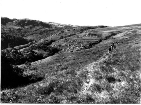
Fig. 8 - Dominating grassland on hilltops and slopes of the Guartelá
Canyon, with copses and gallery woods containing Araucaria.
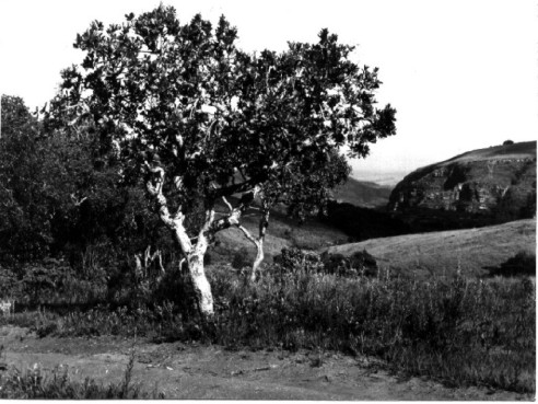
Fig. 9 - Typical savanna tree (Ouratea spectabilis, family
Ochnaceae) in enclave on hilltop in the Guartelá Canyon.
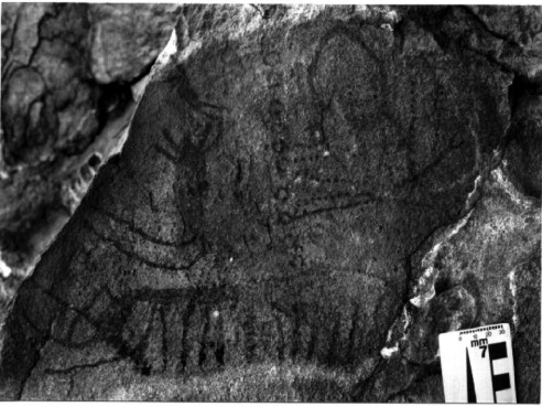
Fig. 10 - Paleoindians cave painting of the Floriano Shelter in the
eastern portion of the State Park of Guartelá, with monochromic zoomorphs attributed to
the Plateau Tradition and associated geometric shapes.
The Campos Gerais region of Paraná was part of the ancient Peabirú
trail, used by the Indians, which linked the Atlantic coast to the hinterland of South
America. On this trail, groups of nomadic Indians travelled in search of better areas to
hunt, pick fruits, harvest or simply discover new lands. The study of the remains in the
region, still incipient, could bring information to clarify the chronological succession
of the cultural blend of the Indian population and the paleoclimatic pressure for the
migratory movements.
Measures for Protection
Some of the dangers to the Guartelá Canyon come from the establishment
of the State Park, creating facilities for visitors, which should cause a considerable
increase in the number of tourists. In the spring of 1999, two years after the
inauguration of the park, the destruction of the vegetation and an onset of the erosive
process on the most frequently used trails pointed to the need to establish trails along
more suitable routes, also taking into account the support capacity of the terrain. There
is a need for more detailed planning of the paths, not only to preserve the park, but also
to take better advantage of the area. The natural and archaeological heritage of the park
are not yet sufficiently well known, and is not shown to visitors, who can spend several
days camping in the region and leave without knowing what are the remains of the
paleoindians who once roamed the area, what ecosystems exist there and their relevance,
which rocks sustain the relief, how the canyon was formed and what its relevance is to an
understanding of the present and former landscape.
The main risk to the Guartelá Canyon, however, is the threat
represented by the exploitation of the areas surrounding the park. Some practices, such as
the burning of fields at the end of the winter, to stimulate growth, and the planting of
Pinus, whose seeds are carried on the wind and which is extremely harmful to native
species, cause a threat of forest fires and the uncontrolled introduction of exotic
species. Only the appropriate management of the entire Devonian Escarpment, already set
aside as an APA (Environment Protection Area) by a state decree in 1992 , but not yet
established as such, could minimise such threats. The management plan of the APA could
also include the establishment of natural habitat corridors, in a way that areas of
preservation, such as the State Park of Guartelá , would not only have the role of
preserving samples of the ecosystem, but would also represent a vital link for the
survival of natural ecosystems in extensive regions (ROCHA 1997).
References
AB'SÁBER, A.N. 1977. Topografias ruineformes no Brasil. Săo Paulo,
USP - Inst. Geografia, Geomorfologia, n.50, 14p.
ASSINE, M.L. 1996. Aspectos da estratigrafia das seqüęncias
pré-carboníferas da Bacia do Paraná no Brasil. Săo Paulo, Instituto de
Geocięncias da Universidade de Săo Paulo, Tese de Doutoramento, 207p.
ASSINE, M.L.; SOARES, P.C.; MILANI, É.J. 1994. Seqüęncias
tectono-sedimentares mesopaleozóicas da Bacia do Paraná, sul do Brasil. Săo Paulo, Rev.
Bras. Geoc., v.24, n.2, p.77-89.
ASSINE, M.L.; ALVARENGA, C.J.S.; PERINOTTO, J.A.J. 1998. Formaçăo
Iapó: glaciaçăo continental no limite Ordoviciano/Siluriano da Bacia do Paraná. Săo
Paulo, Rev. Bras. Geoc., v.28, n.1, p.51-60.
BEHLING, H. 1997a. Studies on Late Quaternary environmental changes in
S and SE Brazil with a focus on the history of the Araucaria forests. In: CONGRESSO DA
ASSOCIAÇĂO BRASILEIRA DE ESTUDOS DO QUATERNÁRIO, 6, Curitiba, 1997. Resumos
expandidos... Curitiba, ABEQUA, p.313-316.
Behling, H., 1997b. Late Quaternary vegetation, climate and fire
history of the Araucaria forest and campos region from Serra Campos Gerais, Paraná
State (South Brazil). Review of Palaeobotany and Palynology, v.97, p.109-121.
BLASI, O. 1972. Cultura do índio pré-histórico do vale do Iapó,
Tibagi, Paraná, Brasil. Curitiba, Arquivos do Museu Paranaense, n.6, 19p. (Nova
Série Arqueologia).
CHMYZ, I. 1976. Nota prévia sobre o sítio PR PG 1: abrigo-sob-rocha
Cambiju. Estudos Brasileiros, Curitiba, n.2, p.231-246.
DIEDRICHS, L.A. 1995. O processo de criaçăo do Parque Estadual do
Guartelá. Curitiba, UFPR, Monografia do Curso de Especializaçăo em Cięncias
Sociais.
FORTES, F.P. 1996. Geologia de Sete Cidades. Teresina,
Fundaçăo Cultural Monsenhor Chaves, 144p.
HERZ, N. 1977. Timing of spreading in South Atlantic: information from
Brazilian alkalic rocks. Geol. Soc. Am. Bull., v.88, p.101-102.
KLEIN, R.M. 1984. Aspectos dinâmicos da vegetaçăo do sul do Brasil. Sellowia,
v.36, p.5-54.
LAMING, A. & EMPERAIRE, J. 1968. Descobertas de pinturas rupestres
nos planaltos paranaenses. Curitiba, Revista do Centro de Ensino e Pesquisas
Arqueológicas, CEPA n.1, p.81-93.
LANGE, F.L.P. 1994. Guartelá: história, natureza, gente.
Curitiba, COPEL, 142p.
LANGE, F.W. & PETRI, S. 1967. The Devonian of the Paraná Basin. In:
Problems in Brazilian Devonian geology. Curitiba, Bol. Par. Geoc., v.21-22, p.5-55.
MAACK, R. 1948. Notas preliminares sobre clima, solos e vegetaçăo do
Estado do Paraná. Curitiba, Arquivos de Biologia e Tecnologia, v.II, p.102-200.
MAACK, R. 1949. Notas complementares ŕ apresentaçăo preliminar do
Mapa Fitogeográfico do Estado do Paraná (Brasil). Curitiba, Arquivos de Biologia e
Tecnologia, v.7, p.351-362.
MAACK, R. 1970. Notas preliminares sôbre as águas do sub-solo da
Bacia Paraná-Uruguai. Curitiba, Comissăo Interestadual da Bacia Paraná-Uruguai,
162p.
MAACK, R. 1981. Geografia física do Estado do Paraná. Rio de
Janeiro, Livraria José Olympio Ed., 442p.
MACHADO, J.A.G. 1999. Repercussăo do ecoturismo em Tibagi, PR.
Ponta Grossa, UEPG, monografia apresentado ao Curso de Especializaçăo em Geografia
Urbana e Análise Ambiental, UEPG-DEGEO, 68p.
MELO, M.S. 1999. Análise sedimentológica dos depósitos da Lagoa
Dourada, Vila Velha, Ponta Grossa, PR. Ponta Grossa, UEPG, Relatório Final de
Pesquisa, 74p. (inédito).
MELO, M.S. & COIMBRA, A.M. 1996. Ruiniform relief in sandstones -
the example of Vila Velha, Carboniferous of the Paraná Basin, Southern Brazil. Acta
Geológica Hispanica, v.31, n.4, p.25-40 (publicado em 1999).
MELO, M.S.; GIANNINI, P.C.F.; SAYEG, I.J. 1999. Kaolinitic clay in the
Furnas Sandstone, Devonian of the Paraná Basin, Southern Brazil. Acta Microscopica,
v.8(A), p.37-38.
MILANI, É.J. 1997. Evoluçăo tectono-estratigráfica da Bacia do
Paraná e seu relacionamento com a geodinâmica fanerozóica do Gondwana Sul-Ocidental.
Porto Alegre, Universidade Federal do Rio Grande do Sul, Tese de Doutoramento, 2 vols.
MILANI, É.J.; FACCINI, U.F.; SCHERER, C.M.; ARAÚJO, L.M.; CUPERTINO,
J.A. s.d. Sequences and stratigraphic hierarchy of the Paraná Basin (Ordovician to
Cretaceous), Southern Brazil. Săo Paulo, Boletim do IG-USP (no prelo).
MINEROPAR - MINERAIS DO PARANÁ S.A. 1989. Mapa Geológico do Estado
do Paraná: escala 1:650.000. Curitiba, MINEROPAR-MME-DNPM.
MORO, R.S. 1998. Interpretaçőes paleolimnológicas do Quaternário
Recente a partir da análise da comunidade de diatomáceas (Bacillariophyceae) no
sedimento da Lagoa Dourada, Ponta Grossa, PR. Tese (doutoramento), Instituto de
Biocięncias. Universidade Estadual Paulista, UNESP, Campus de Rio Claro, 141p.
PARELLADA, C.I. s.d. Caracterizaçăo do patrimônio arqueológico -
Parque Estadual do Canyon Guartelá. Curitiba, Museu Paranaense, texto inédito.
PESSENDA, L.C.; VALENCIA, E.P.E.; CAMARGO, P.B.; TELLES, E.C.C.;
MARTINELLI, L.A.; CERRI, C.C.; ARAVENA, R.; ROLANSKI, K. 1996. Natural radiocarbon
measurements in Brazilian soils developed on basic rocks. Radiocarbon, v.38, n.2,
p.203-208.
PROUS, A. 1992. Arqueologia Brasileira. Brasília, Editora
Universidade de Brasília.
RAMOS, A.N. & FORMOSO, M.L.L. 1975. Argilominerais das rochas
sedimentares da Bacia do Paraná. Rio de Janeiro, Cięncia - Técnica - Petróleo, Seçăo
Exploraçăo de Petróleo, n.9, 72p. e anexos.
ROCHA, C.H. 1997. Parque Estadual do Guartelá - o louvável, o
questionável e o lastimável. In: CONGRESSO BRASILEIRO DE UNIDADES DE
CONSERVAÇĂO, Curitiba, 1997. Anais... Curitiba, IAP-UNILIVRE, v.2, p.294-306.
SAINT-HILAIRE, A. 1978. Viagem a Curitiba e Província de Santa
Catarina. Săo Paulo, Livraria Itatiaia Editora Ltda.
SCHIMITZ, P.I. 1997. Arqueologia nos cerrados do Brasil Central. In:
Serranópolis II, As pinturas rupestres e gravuras dos abrigos. Săo Leopoldo, UNISINOS,
Instituto Anchietano de Pesquisas.
SILVA, A.G.C. 1999. Pinturas rupestres do sítio arqueológico
Abrigo Usina Săo Jorge, Ponta Grossa - PR. Ponta Grossa, UEPG-DEGEO, Monografia de
Graduaçăo do Curso de Bacharelado em Geografia, 52p.
Takeda, I.J.M.; Moro, R.S.; Kaczmarech, R. 1996. Análise florística
de um encrave de cerrado no Parque do Guartelá, Tibagi, PR. Publicatio UEPG
- Cięnc. Biol., Ponta Grossa, v. 2, n. 1, p.21-31.
TREIN, E.; FUCK, R.A.; LOPES, J.A. ; MURATORI, A. ; PALKA, J. 1966a.
Folha geológica de Colônia Iapó, escala 1:50.000. Curitiba, Comissăo da Carta
Geológica do Paraná.
TREIN, E.; FUCK, R.A.; LOPES, J.A.; PALKA, J.; MURATORI, A. 1966b.
Folha geológica de Tibagi, escala 1:50.000. Curitiba, Comissăo da Carta Geológica do
Paraná.
VELOSO, H.P. & GÓES FILHO, L. 1982. Fitogeografia brasileira -
classificaçăo fisionômica-ecológica da vegetaçăo neotropical. Salvador, Bol.
Téc. Proj. RADAMBRASIL, série vegetaçăo, n.1, p.1-80.