|

SIGEP
Geological
and Paleontological Sites of Brazil - 085
Sincorá
Range, Bahia state
Date:03/03/2001
Augusto
J. Pedreira
augusto.pedreira@terra.com.br
CPRM-Geological
Survey of Brazil
Av. Ulysses Guimarães, 2862 - CAB
41213-000 Salvador, Bahia, Brazil
Phone: +55(71)230-9977
© Pedreira,A.J. 2001. Sincorá Range, Bahia state. In: Schobbenhaus,C.; Campos,D.A.; Queiroz,E.T.; Winge,M.; Berbert-Born,M. (Edit.) Sítios Geológicos e Paleontológicos do Brasil. Published
3//3/2000 n Internet at the address http://www.unb.br/ig/sigep/sitio085/sitio085english.htm [Actually
https://sigep.eco.br/sitio085/sitio085english.htm]
[SEE
PRINTED CHAPTER IN PORTUGUESE]
(The above bibliographic reference of author copy rights is required for any use of this article in any media, being forbidden the use for any commercial purpose)
|
ABSTRACT
The
Sincorá range is an orographic system of north-south trend bounded by the
coordinates 12015' - 13045'S and 41010' - 41030'W.
The ranges, that take several local names alternate heights above 1200m with
narrow and deep valleys, whose escarpments and waterfalls compose breathtaking
landscapes. The rocks that form the Sincorá range are mostlysandstones and
conglomerates of the Tombador Formation, of Mesoproterozoic age. The sedimentary
structures of these rocks are perfectly preserved, allowing its approach under
the depositional systems and sequence stratigraphy view points. The structure of
the range is an anticlinorium whose axis undulate in the vertical plane. The
TombadorFormation conglomerates are diamond bearing, and were washed since their
discovery in 1844. From 1871 on, there was a dramatic decrease in the
production, but presently there are still scattered washings. The northern half
of the Sincorá range is within the Chapada Diamantina National Park and farther
north is the Iraquara-Marimbus Environmental Protection Area; in the region of
the town of Mucugê, there is a municipal park of environmental protection, in
the area of the Sempre Viva Project.
Key
words: Sincorá range; Chapada Diamantina; sedimentary rocks; structural
geology; diamond; Proterozoic
INTRODUCTION
The
Sincorá range, located in the central part of Bahia State (Brazil), is a region
of great scenic beauty owing to the
shaping of its ranges, that expose deep valleys with steep escarpments and wide
plateaus. These escarpments allow the examination of stratigraphic sections and
sedimentary structures of the bedrocks,
where long ago were exploited diamonds.
In
1818, the german naturalists J.B. von Spix and C.F. von Martius examined the
rocks of this range in the Sincorá Velho village, and compared them with the
rocks of the Tijuco in Minas Gerais Province, where diamonds were washed (Spix
and Martius, 1838). The discovery of diamonds in the Mucugê and Combucas rivers
in 1844, attracted to the region a large number of explorers and adventurers.
So, in 1847, the General Inspector of the Diamond Regions of Bahia Province,
Benedicto Marques da Silva Acauã, forwarded a report to the Imperial Government
about the region. The second part of the report is a detailed account about the
geomorphology of the Sincorá range and its surroundings, as well as its mineral
resources, both real and potential (Acauã, 1847). Besides the explorers and
adventurers, the presence of the diamonds also attracted scientists to region
(Moraes, 1991).
In
the year of 1880, the engineer Theodoro Sampaio visited the town of Santa Isabel
do Paraguaçu (nowadays Mucugê), located in the Sincorá range itself "...
in the very center of the diamond mines of Bahia..." (Sampaio, 1955).
Visiting the Nova Sibéria garimpo (diamond washing), located in the Paraguaçu
river, he identified the rocks as "... the same geologic facies of the
Sincorá range".
The
foundations of the Chapada Diamantina stratigraphy were established by the
American geologist Orville A .
Derby in his visit to the region (Lençóis, Andaraí,
Chique-Chique -- presently Igatu, Santa Isabel do Paraguaçu and Palmeiras), in
the year of 1904. In a report to the Secretary of Agriculture of Bahia State, he
described the sandstones and conglomerates and the structure of the Sincorá
range (Drby, 1904). Later, he named them Paraguaçu and Lavras groups,
respectively (Derby, 1906).
Following
these prime descriptions, the geology of the Sincorá range has been approached
under several points of view: stratigraphy and regional geology (Derby, 1905;
1906; Kegel, 1959; Mascarenhas, 1969; Pedreira et al., 1974); depositional
systems (Guimarães & Pedreira, 1990; Bomfim & Pedreira, 1990; Pedreira
& Margalho, 1990: Pedreira, 1997); and sequence stratigraphy (Pedreira,
1988; 1994; 1995; Savini & Raja Gabaglia, 1997).
In
recent times, emphasis have been given to studies related to the environment
(CPRM, 1994; Funch, 1997).
LOCATION
The
Sincorá range is located in the central region of Bahia State, in the area
bound by the coordinates 12015' - 13045'S e 41010'
- 41030'W, about 400km far from the city of Salvador, the state
capital (figure 1). The region comprises sectors of the Lençóis, Palmeiras,
Andaraí, Mucugê and Barra da Estiva municipalities, as well as the villages of
Caeté Açu, Guiné, Igatu, Cascavel, Mundo Novo and Sincorá Velho of the above
municipalities. The region may be
reached through the BR-242 road
(Salvador-Brasília) and within it through paved state roads that connect it to
the towns of Lençóis, Palmeiras, Andaraí, Mucugê and Barra da Estiva. Other
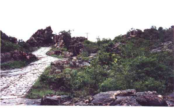
settlements may be reached by unpaved local roads; between the BA-142 road and
Igatu village, the roads are paved with stone slabs. By air, there are regular
lines to the Col. Horácio de Matos, located in Tanquinho village.
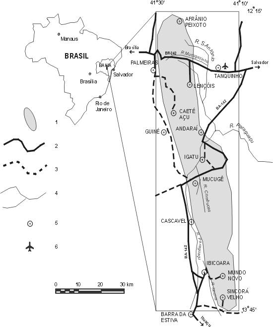
Figure
1 - Location map of the Sincorá range. Explanation: 1- Region of the range;
2-Paved road; 3-Unpaved road; 4-River; 5-Town or village; 6-Airport.
SITE
DESCRIPTION
The
Sincorá range is located in the central-eastern escarpment of the Chapada
Diamantina, approximately between the villages of Afrânio Peixoto (previously
Estiva ) in the north and Sincorá Velho in the south (figure 1). Its western
flank is an almost continuous escarpment, 300m high and 80km long and the
eastern that dominates the plains of the Paraguaçu river valley (400m), reaches
abruptly the altitude of 1200m in
the first crests of the range (Funch, 1997).
Geomorphology
North-south
trending faults of great lenght and smaller ones transverse to them, divide it
into countless blocks that take local names, as the Cravada, Sobrado, Lapão,
Veneno, Roncador or Garapa, Esbarrancado (part of the western escarpment), Rio
Preto ranges, among many others. These ranges have peaks up to 1700m high and
are separated by steep valleys, deep as canyons.
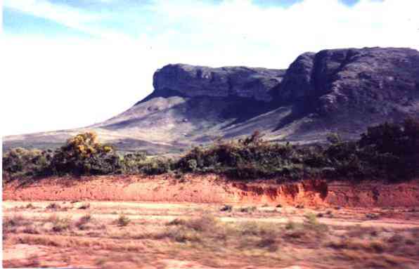
A
landmark that stands out in the Sincorá range is the Pai Inácio mountain,
located in the western limb of the anticline of same name, that forms the
Cercado valley (figure 2).
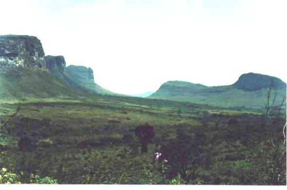 Figure
2 - Cercado valley in the Pai Inácio anticline, south of the BR-242 road
Figure
2 - Cercado valley in the Pai Inácio anticline, south of the BR-242 road
North
of the road, is the Camelo or Calumbi mountain, an outlier within the anticline
(figure 3), and
in the south, in similar situation, the Morrão (figure 4), whose access is
through road from the town of Palmeiras and the village of Caeté Açu.
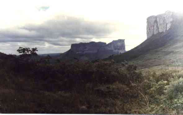
Figure
3 - Camelo or Calumbi mountain
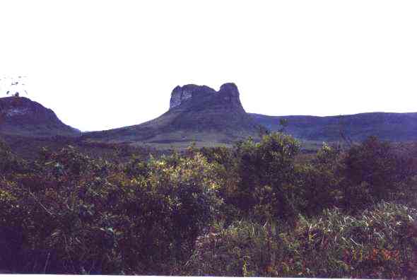 Figure
4 - Morrão
Figure
4 - Morrão
Before
reaching the village of Caeté Açu, one crosses the bridge on the Riachinho
river (figure 5). Close to this place, is the Riachinho cave, 201m long and 26m
high (Laureano & Cançado, 1995).
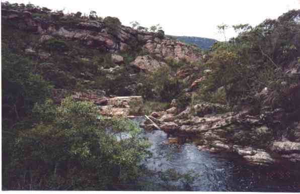 Figure
5 - Riachinho river
Figure
5 - Riachinho river
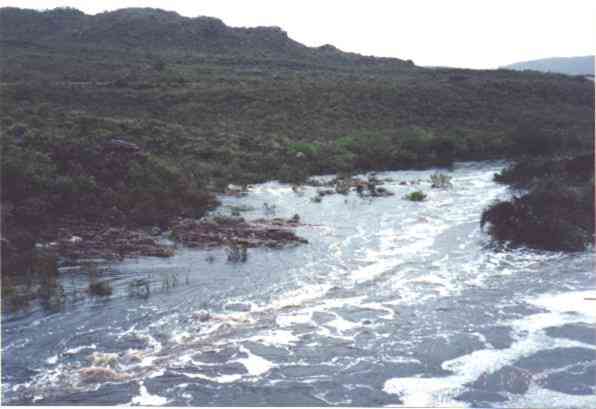
The
Paraguaçu river, after crossing the Sincorá range, leaves it in the locality
of Passagem de Andaraí, in the
Donana waterfall (figure 6). From there, it starts meandering on the limestone
plain, towards the Atlantic ocean in Todos os Santos bay.
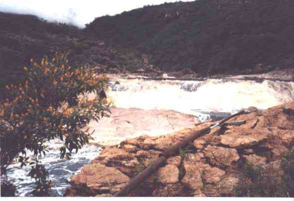 Figure
6 - Donana waterfall
Figure
6 - Donana waterfall
Beyond
the Cercado valley, already mentioned, in the southern end of the Sincorá
range, there is another valley named Campo Redondo. Its entrance is shown in the
figure 7, where are seen the western escarpment of the range and the Sincorá
river valley.
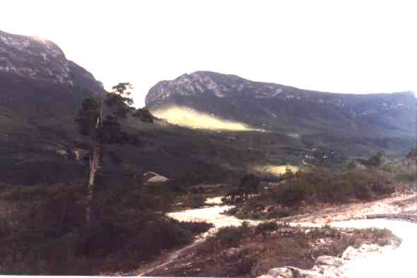
Figure
7 - Road to Campo Redondo, looking to part of the western escarpmemt of the
range and the valley of the Sincorá river.
Geology
The
rocks that crop out in the Sincorá range are essentially Mesoproterozoic
sediments of the Tombador Formation; this formation was described by Branner
(1910), about 180km north of this
region. In the Sincorá range, the Tombador Formation overlies the Guiná
Formation (figure 8). The structure of the range is a huge anticlinorium with undulating axis. The upwards undulations are in the
central regions of the range, between the Pai Inácio mountain and the village
of Guiné, and between the towns of Mucugê
and Barra da Estiva. In these places, crop out the rocks of the underlying Guiné
Formation.
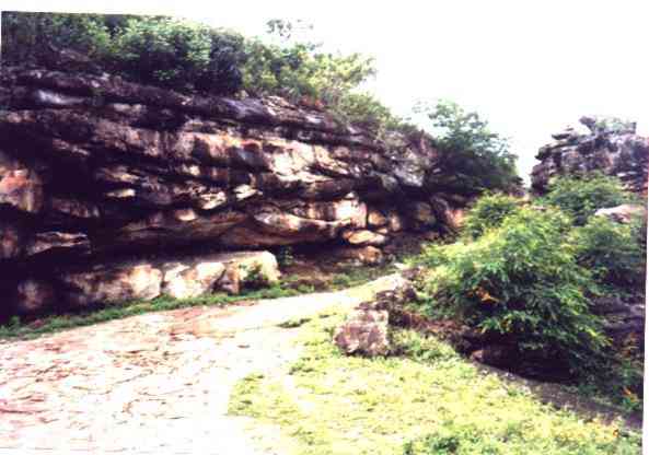
 Figure
8 - Contact between the Guiné and Tombador
formations in Comércio de Fora, west of the town of Mucugê. The rocks
of the former (siltstones and sandstones) have gentle land forms; the ones of
the latter (sandstones and conglomerates ) form the escarpment.
Figure
8 - Contact between the Guiné and Tombador
formations in Comércio de Fora, west of the town of Mucugê. The rocks
of the former (siltstones and sandstones) have gentle land forms; the ones of
the latter (sandstones and conglomerates ) form the escarpment.
The
contact between these formations, the former of marine, and the latter of
continental environment, is interpreted as a type 1 sequence bounding surface
(Pedreira, 1994).
The
sandstones and conglomerates of the Tombador Formation are shown in the figures
9 and 10.
 Figure
9 - Sandstones of the Tombador Formation in the village of Igatu. Note the
trunctions between beds, with channel shapes.
Figure
9 - Sandstones of the Tombador Formation in the village of Igatu. Note the
trunctions between beds, with channel shapes.
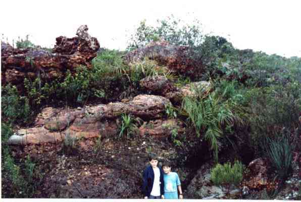 Figure 10 - Interbedded conglomerates and sandstones of the Tombador Formation. Valley
of the Combucas river, north of the town of Mucugê.
Figure 10 - Interbedded conglomerates and sandstones of the Tombador Formation. Valley
of the Combucas river, north of the town of Mucugê.
The
study of the Tombador Formation lithologies and associated sedimentary
structures, allowed the determination of its depositional environments, as shown
by the graphic sedimentary logs of the figure 11.
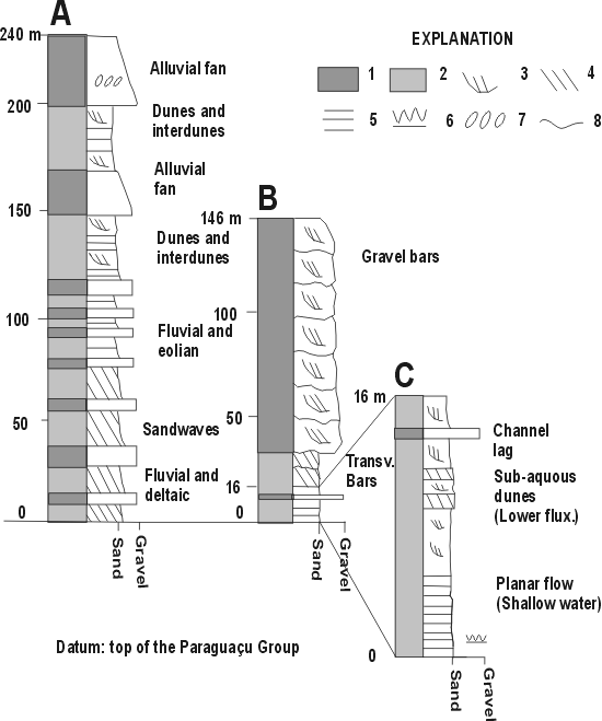
Figure
11 - Graphic sedimentary logs of the Tombador Formation in the Sincorá range. A
- BR-242 road, between the Pai Inacio mountain and the top of the formation
(modified from Guimarães & Pedreira, 1990); B - Cruzeirão muontain in the
town of Mucugê. Explanation:
1-Clast supported conglomerate; 2-Sandstone; 3-Trough cross bedding; 4-Tabular
cross bedding; 5-Horizontal bedding; 6-Ripple marks; 7- Clast imbrication;
8-Amalgamation.
Diamonds
In
the year of 1844 were discovered diamonds in the Sincorá range, in the region
of Mucugê (figures 1 and 12). From there, all the range was exploited, being
washed (garimpados) diamonds since the Sincorá river in the south, up to the
Afrânio Peixoto region in the north (figure 1).
 Figure
12 - Combucas river, north of the town of Mucugê, close to the mouth of the
Mucugê river, place of the first discoveries of diamonds in the Sincorá range.
Figure
12 - Combucas river, north of the town of Mucugê, close to the mouth of the
Mucugê river, place of the first discoveries of diamonds in the Sincorá range.
The
diamonds were washed from the gravel produced by the weathering of the
oligomictic conglomerates as that of figure 13, or
polymictic as those of the Serrano waterfall (figure 14), shown in detail in the
figure 15.
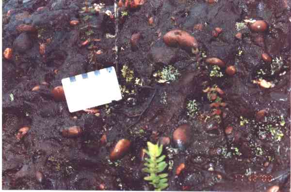 Figure
13 - Detail of the conglomerate of rio Combucas valley (figure 10) interpreted
as fluvial.
Figure
13 - Detail of the conglomerate of rio Combucas valley (figure 10) interpreted
as fluvial.
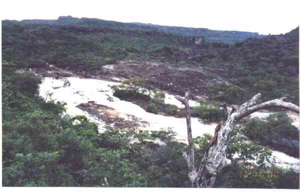 Figure
14 - Serrano waterfall in the town of Lençóis.
Figure
14 - Serrano waterfall in the town of Lençóis.
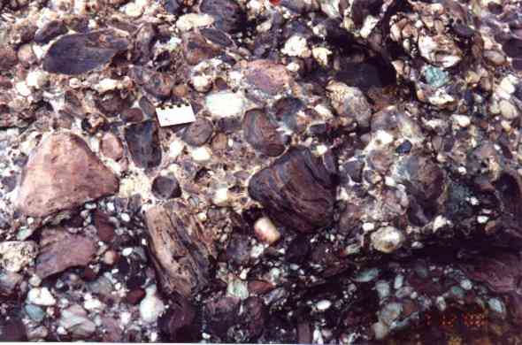 Figure
15 - Polymictic conglomerate of the Serrano
waterfall, interpreted as alluvial fan.
Figure
15 - Polymictic conglomerate of the Serrano
waterfall, interpreted as alluvial fan.
The
washing of diamonds was also intensive in the regions of Andaraí and Igatu. The
figure 16 shows the conglomerates in the road between these two localities. The
debris discarded from the ancient washings still can be seen along the road.
 Figure
16 - Conglomerates along Andaraí - Igatu road
Figure
16 - Conglomerates along Andaraí - Igatu road
After
a glorious period of about 25 years, the manual washing of diamonds began to
decline from 1871 on (CPRM, 1994). The first attempts to mechanize the works
were made in the first half of the XX century (Catharino, 1986). In the
eighties, the mechanized washings started again, in the beds of the rivers, both
inside and outside of the National Park. These activities, thanks to a joint
action of several agencies related to mining and the environment,
were definitely discontinued in March, 1996.
Even
after 150 years of exploitation of the diamond bearing alluvium, there still
exists manual washings, although in a slower pace, owing to the exhaustion and
decrease of the works (Funch, 1997). Due to the unlimited number of geologic and
topographic settings of the range, there are the following types of manual
washings, each one with its characteristic features: "cascalhão"
(high ledges with gravel and sand), "barranco"(high ledge of clay with
a thin bed of gravel), "brejo"(low and moist area with little soil on
the gravel), "grupiara"(gravel in the range),
"emburrado"(area with rock boulders), "curriolo"(washings in
the bed of a river, with much gravel and loose cobbles),
"engrunada"(underground works), "gruta"(natural cave in the
range), "escafandro"(underwater works made by divers), "serviço
a seco"( dry service; work in a place without water),
"lavagem"(rework of debris from old washings) and "faísca"(small
washing made in one day), (figure 17).
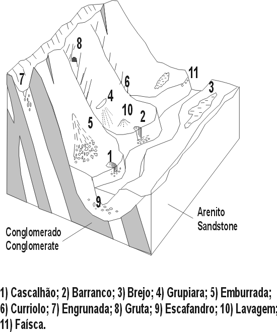
Figure 17 -Schematic
rendering of the manual garimpo types (descriptions in the text)
These
facts confirm Derby's (1905) statement: "Regarding the mineral wealth, the
only one profitable until today are the diamonds and carbonados, and its
geologic framework [of the Sincorá range] offers little hope of the existence
of another".
PROTECTION
MEASURES
The
sector of the range between Cascavel and Mucugê, and the BR-242 road, is within
the Chapada Diamantina National Park. This park was created in September 17,
1985 by the Federal Decree no. 91655. Its area is 1520 sq. km, and encompasses
part of the Lençóis, Andaraí, Mucugê, Palmeiras and Ibicoara municipalities,
excluding the towns themselves (CPRM, 1994). North of the BR-242 road, the Pai
Inácio and Camelo mountains are within the Iraquara-Marimbus APA (Area of
Environmental Protection).
According
to information of the biologist Roy Funch (Director of the Environmental
Department of Lençóis Municipality), the Mucugê river, in whose beds were
discovered the first diamonds, is reasonably well protected: upstream it is
inside the National Park, and downstream in within the area of the Mucugê
Municipal Park (a reserve with about 2.7 sq. km). This park also encompasses the
low course of the Combucas river and several of its tributaries, and borders the
National Park.
Besides
these measures, there is in Mucugê municipality, the Sempre Viva Project. This
project has the following aims: 1) to run a conservation unit for eco-touring in
the Mucugê Municipal Park; 2) development of technology for the reproduction of
native vegetation; 3) operate a Geographic Information System (GIS); and 4)
carry out a program of environmental education. Its offices, built in the style
of the old shelters of the "garimpeiros", is shown in the figure 18.
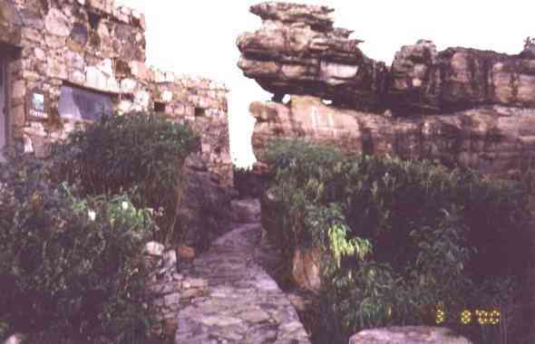 Figure
18 - Part of the Sempre Viva Project facility
Figure
18 - Part of the Sempre Viva Project facility
BIBLIOGRAPHIC
REFERENCES
Acauã,B.M.S.
1847. Relatório
dirigido ao Governo Imperial em 15 de abril de 1847, pelo Inspector Geral dos
Terrenos Diamantinos da Província da Bahia. Rev.
Trim. do Inst. Hist. Geogr. Ethnogr. Brasil, 9
: 227-260
Bomfim, L. F.; Pedreira,
A .J. (orgs.), 1990 Programa
Levantamentos Geológicos Básicos do Brasil.Escala 1:100.000. Folha SD.24-V-A-V
(Lençóis). Brasília, DNPM/CPRM, 130p.
Branner, J.C. 1910. The
Tombador escarpment in the State of Bahia, Brazil. Am.
Jour. Sci. 30: 335-343
Catharino, J.M. 1986. Garimpo-Garimpeiro-Garimpagem,
Chapada Diamantina, Bahia. Rio de Janeiro, Philobiblion/Banco Econômico,
270 p.
CPRM-Companhia de Pesquisa de
Recursos Minerais, 1994. Projeto Chapada
Diamantina: Parque Nacional da Chapada Diamantina-BA: Informações Básicas
para a Gestão Territorial: Diagnóstico do Meio Físico e da Vegetação.
Salvador, CPRM/IBAMA, 104 p.
Derby, O .A.
1905.
Lavras Diamantinas. Rev. Inst.
Geogr. e Hist. da Bahia, 11 (30):
143-153
Derby, O .A.
1906.
The serra do Espinhaço, Brazil. Jour.
Geology, 14: 374-401
Funch,R. 1997. Um
guia para o visitante da Chapada Diamantina: o Circuito do Diamante: o Parque
Nacional da Chapada Diamantina; Lençóis, Palmeiras, Mucugê, Andaraí.
Salvador, Secretaria de Cultura e Turismo/EGBA, 209 p. (Coleção Apoio).
Guimarães, J. T.;
Pedreira, A .J. (orgs.),1990 Programa
Levantamentos Geológicos Básicos do Brasil.Escala 1:100.000. Folha
SD.24-V-A-II (Utinga). Brasília, DNPM/CPRM, 141p.
Kegel, W. 1959. Estudos
geológicos na zona central da Bahia. Rio de Janeiro, DNPM/DGM. 35 p.
(Boletim no. 198)
Mascarenhas, J. F. 1969.
Contribuição à estratigrafia da Chapada Diamantina na região entre Itaetê e
Seabra. In: Congresso Brasileiro de Geologia, 23, Salvador. Resumo
das Conferências e Comunicações : 59-60.
Moraes,W. 1991. Jagunços
e Heróis. 4ed. Salvador, Empresa Gráfica da Bahia/IPAC, 217 p.
Pedreira, A .J .;
Margalho, R.S.F.X. 1990. Programa
Levantamentos Geológicos Básicos do Brasil.Escala 1:100.000. Folha
SD.24-V-C-II (Mucugê). Brasília, DNPM/CPRM, 112p.
Pedreira, A.J.; Arcanjo,J.B.; Pedrosa,C.J.; Oliveira,J.E.; Silva, B.C.E. 1975. Projeto
Bahia: Geologia da Chapada Diamantina. Salvador, DNPM/CPRM, 2 vol. (relatório
inédito / unpublished report)
Pedreira, A.J. 1988. Seqüências deposicionais no Precambriano: exemplo da Chapada Diamantina
oriental, Bahia. In: Congresso Brasileiro de Geologia, 35, Belém. Anais, 2: 648-659
Pedreira, A.J. 1994 . O
Supergrupo Espinhaço na Chapada Diamantina centro-oriental, Bahia:
Sedimentologia, Estratigrafia e Tectônica. Inst. de Geociências,
Universidade de São Paulo, São Paulo.Tese de Doutoramento, 126 p.
Pedreira, A.J. 1995.
Registro da sedimentação em uma margem continental no Precambriano: Formação
Guiné, Chapada Diamantina, Bahia. Revista
de Geologia, 7: 5-15
Pedreira, A.J.
1997.
Sistemas deposicionais da Chapada Diamantina Centro-Oreiental, Bahia. Revista
Brasileira de Geociências, 27: 229-240
Sampaio,T.
1955.
O rio São Francisco e a Chapada Diamantina. Salvador, Livraria Progresso
Editora, 278p. (Coleção de Estudos Brasileiros)
Savini, R.R.; Raja
Gabaglia,G.P. 1997. Curso de Campo da
Chapada Diamantina. Salvador, Petrobras, SEREC/CEN-SUD, 15p.
Spix, J.B. von; Martius,
C.F.von. 1938. Através da Bahia;
Excerptos da obra Reise in Brasilien. 3ed. São Paulo, Companhia Editora
Nacional, 342 p. (Tradução de Pirajá da Silva e Paulo Wolff).