
SIGEP
Geological and Paleontological Sites of Brazil - 069
The Pleistocene Palaeontological Site of Toca da Janela da
Barra do Antoniăo,
Săo Raimundo Nonato, Piauí state
Date:27/10/1999
Claude
Guerin *
guerin@cismsun.univ-lyon.fr
Martine Faure
**
martine.faure@lyon.mom.fr
Paulo R.
Simőes ***
fumdham@zaz.com.br
Marguerite Hugueney
*
m-hugue@cismsun.univ-lyon.fr
Cécile Mourer-Chauvire
*
mourer@cismsun.univ-lyon.fr
*The Centre for Stratigraphical Palaeontology and Palaeoecology associated with CNRS
(UMR 5565), UFR of Earth Sciences, Claude Bernard University – Lyon I, 27-43
Boulevard du 11 Novembre, 69622 Villeurbanne Cédex, France , and Fundaçăo Museu do
Homem Americano, Săo Raimundo Nonato, Piauí, Brazil.
** UMR 5565 e Universidade Lumičre-Lyon 2, 7 rue
Raulin, 69007 Lyon, França, e Fundaçăo Museu do Homem Americano, Săo Raimundo Nonato,
Piauí, Brasil.
** UMR 5565 Lumičre-Lyon University 2, 7 rue Raulin, 69007 Lyon, France and
Fundaçăo Museu do Homem Americano, Săo Raimundo Nonato, Piauí, Brazil.
*** Fundaçăo Museu do Homem Americano, Săo Raimundo
Nonato, Piauí, Brasil. Rua Abdias Neves, 551 64770-000 Săo Raimundo Nonato - PI
© Guerin,C.; Faure,M.; Simőes,P.R.; Hugueney,M.; Mourer-Chauvire,C. 1999. The Pleistocene Palaeontological Site of Toca da Janela da Barra do Antoniăo (Săo Raimundo Nonato, Piauí state). In: Schobbenhaus,C.; Campos,D.A.; Queiroz,E.T.; Winge,M.; Berbert-Born,M. (Edit.) Sítios Geológicos e Paleontológicos do Brasil. Published on Internet at the address http://www.unb.br/ig/sigep/sitio069/sitio069english.htm
[Actually
https://sigep.eco.br/sitio069/sitio069english.htm]
[SEE
PRINTED CHAPTER IN PORTUGUESE]
(The above bibliographic reference of author copy rights is required for any use of this article in any media, being forbidden the use for any commercial purpose)
|
ABSTRACT
In the Southeast of
Piauí, a karstic area of reduced dimensions is home to a large number of hollows
containing archaeological and palaeontological remains and palaeoclimatic indicators.
These hollows, which are situated in the vicinity of the Serra da Capivara National Park,
are directly related to the other archaeological sites in the region. The site at Toca da
Janela da Barra do Antoniăo stands out as the main site of the carstic region where
excavations have uncovered evidence of a rich pleistocene fauna, human burial, rock
paintings and stone material associated with the megafauna. Taken together, the analysis
of these remains will enable a greater understanding of Brazilian pre-history and of the
evolution of Brazil’s natural environments.
INTRODUCTION
Toca da Janela da Barra do Antoniăo is the most important site in the carstic area
located in the Săo Raimundo Nonato region of the Southeast of Piauí. It is found in a
residual carste situated in the south of the Serra de Capivara National Park where there
are other hollows with fossiliferous deposits.
Since 1986, research carried out in the carstic region has provided evidence for a
rich pleistocene fauna, with Holocene remains very often including connected skeletons.
The presence was also noted of micro-mammals, diverse bird life, crocodilians, chelonians,
lithic material associated with the bones of mega-mammals, bones showing evidence of
having been used, burials and rock paintings. Excavations carried out at Toca do
Garrincho, Toca de Cima do Pilăo and Toca do Serrote do Artur showed evidence of material
of a similar nature, which led us to presume that they were relatively contemporaneous.
These excavations revealed 50 taxa of mammals, of which 20 are extinct. The
pleistocene mega-mammals and the birds are well represented, thus showing that open areas
predominated in the region, with an abundant herbaceous stratum, substantial forested
areas, lower annual average temperatures than are experienced today and a larger
hydro-circulation.
The sedimentological study of the chemical and physical deposits and the
establishment of their chronology, the micrographic study, the anthracological,
palynological and malacological analyses, as well as the study of the biostratigraphic,
biogeographic and biochronological relations, together contribute to the hope that a
better understanding will be gained of the palaeo-environmental context of a culturally
rich and diverse region.
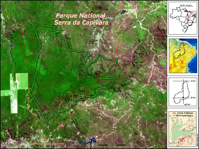
Figure 1 : General View of Serra da Capivara National Park
LOCATION
Situated in the Southeast of the State of Piauí, in the region
known as "Polígono das Secas" ("The Drought-ridden Polygon"), the
Archaeological Area of the Serra da Capivara National Park encompasses and protects in
excess of 400 archaeological and palaeontological sites. Taken as a whole, the research
projects carried out here have provided a source of data that will enable a greater
understanding of Brazilian pre-history (Arnaud et al, 1984).
The area corresponds to the region between Southerly latitudes 8°
and 9°30’ and between Easterly longitudes 30° and 43°30’, with a land area of
40,000 km2. It possesses a dry climate of type BShw (Koppen). Precipitation is
irregular in terms of both location and time of occurrence, with annual averages of around
650mm. The rainy season generally occurs between October and the end of April. Rainfall is
typically localised and brief. The annual potential evapo-transpiration is estimated at
approximately 1400 mm, according to the Thornthwaite method.
The annual average temperature is high (28°C), with an annual
range of temperature variation of about 5°C. The coldest month is June, with a minimum
temperature of 12°C, a maximum of 35°C and an average of 25°C. The beginning of the
rainy season is the hottest period of the year, with an average of 31°C, maximum
temperatures of 45°C and minimum temperatures of 22°C.
Bushy scrub that is difficult to penetrate is the characteristic
vegetation of the region, but areas of forest occur in the ravines, where the largest
concentrations of water are to be found.
Two major geomorphological territories are found in the region. To
the South lies the Peripheral Depression of the Săo Francisco, with Pre-Cambrian tectonic
and migmatized rocks that constitute its crystalline foundation. To the North, a second
territory is made up of the sedimentary rocks of the Parnaíba Basin, which date from the
Palaeozoic and Mesozoic.
The relief of the Peripheral Depression of the Săo Francisco, with
altitudes reaching about 400m, is characterised by a vast plain from which rise up
gneissic and quartzite inselbergs, intrusive granite batholiths, smooth micaceous rocks as
well as metamorphosed limestone outcrops.
The relief of the sedimentary rocks of the the Parnaíba Basin
forms a extensive flat surface, the altitudes of which range between 500m and 650m,
generally terminating in abrupt escarpments. This landscape has a rugged appearance owing
to its easily fractured structure, forming gullies, towers and arcs.
It is in these gullies that the largest concentration of
archaeological sites containing rock paintings has been found in this region, having been
researched since 1970 by the Franco-Brazilian Mission of Piauí. In 1979, the Serra da
Capivara National Park was created, and was later declared to be part of the Cultural
Heritage of Mankind by UNESCO in 1991. Conservation and research policies were
consolidated following the creation of Fundaçăo Museu do Homem Americano (The Museum of
American Man Foundation) – FUMDHAM – in 1986. The National Park and its
surroundings are jointly administrated by FUMDHAM and IBAMA.
The Serra da Capivara National Park encompasses an area of 130,000
hectares, and falls variously within the local administrative regions of Săo Raimundo
Nonato, Coronel José Dias, Joăo Costa and Brejo do Piauí. Its southern flank is defined
by the line of cuesta, an abrupt escarpment varying in height from 80m to 150m. In front
of the cuesta, at a distance of a few kilometres, two karstic zones stand out in the
landscape, rising nearly 100m above the level of the plain.
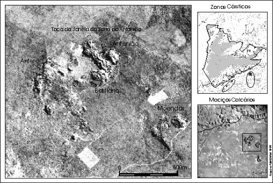
Figure 2 : View of Karstic Area
HISTORY
The karstic zones consist of a residual karst, made up of various
small hills, amidst which are found a hundred or so hollows including archaeological and
palaeontological sites. These two karstic zones are considered to be a single geological
unit, where the separate hills are small limestone plates tilted upwards due to a phase of
tectonic pressure.
The karst of the Archaeological Area of Săo Raimundo Nonato
displays a rugged surface, generally bare of vegetation, with small hollows owing to the
tectonic separation and segmentation of the solid outcrops. It occurs in a calcitic,
micro-crystalline, finely-stratified, metamorphic rock.
Research into these sites, which are so favourable to the
preservation of fossils, began in 1986 and has revealed a rich pleistocene fauna, rock
paintings, burials, as well as stone and ceramic material. Excavations have taken place at
Toca do Garrincho, Toca de Cima dos Pilăo, Toca do Serrote do Artur, and significantly at
Toca da Janela da Barra do Antoniăo, currently the most important palaeontological site
in the region (Guérin et al, 1993, 1996).
Its proximity to the line of the cuesta places it within the
spatiofunctional complex of Toca do Boqueirăo do Sítio da Pedra Furada, a key
archaeological site in the region with human occupation reaching back to 50,000 B.P.
Following its discovery in 1986, this site was excavated until 1990
by Ničde Guidon (Guidon et al, 1993). Various human occupations, including stone industry
and bones showing marks of human origin, were discovered. In July 1990, the remains of the
skeleton of a particularly delicate young woman of small stature were found (pieces of
skull, an incomplete jaw bone, long bones, carpus and metacarpus, vertebrae, and ribs).
They were discovered under enormous fallen blocks in the upper part of the deposit and
were dated as being 9700 years of age ( Peyre, 1993 ).
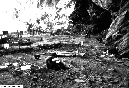
Figure 3 - The site under excavation
DESCRIPTION OF THE SITE
Toca Da Janela Da Barra Do Antoniăo is located at
08ş48’09"S - 42ş25’01"W (Barragem map
1/100 000). Its orientation is SE/NW and it is open to the NE. It is situated in the
Serrote do Antoniăo, the largest limestone solid rock formation in the zone, extending
600m N/S and 450m E/W, with an area of 0.3 km2. The base of the site is below
the surrounding level of sedimentation, thus acting as a point of convergence for surface
water in the rainy periods and contributing to the formation of fossil deposits.
This hollow constitutes a vast shelter under rock oriented to the
North. It has a width of 180m, a depth of 28m, and a deposit of up to 8m in depth. The
excavated surface, which extends over 750m2, was divided into 4 sectors from
East to the West: D, A, B and C. A trench of 72m in length was opened from the East to the
West underneath and within the limits of the shelter. A regular slope may be observed
towards the East. Effectively the whole wall of the shelter shows large orifices
corresponding to the arrival of water along channels made during the rainy periods. The
presence of numerous rock fragments consisting of materials originating outside the
immediate vicinity (gneiss, quartzite), and the presence of bones, confirm this
intra-karstic palaeo-circulation.
On an initial analysis, the stone industry includes 1918 pieces, of
which 394 are pebble tools (45 used, 227 pebbles retouched using one or various instances
of retouching , 122 retouched pebbles –choppers, chopping-tools and polyhedrons) and
271 unused stones. We counted 142 flakes with a cortex and 214 without, among which 82 had
not been retouched. The flake tools amount to 129: burins, scrapers, tools with
engravings, etc. ; there are 74 flake fragments and 16 splinters. There are 199 cores and
we counted 479 fragments of stones and undetermined objects.
The used stones come primarily from sector A and then from sectors
D, C and B. The retouched stones are divided among the various sectors according to the
following distribution: 42% in A, 22% in C and D, and 14% in B. The flakes which had not
been retouched, but had in some cases been used, were more numerous (50% in C, 33% in A,
9% in B and 8% in D) than those which had been retouched. The distribution of flake tools
is as follows: 48% in C, 22% in A, 21% in D and 9% in B. The 199 cores have the following
distribution: 37% in A, 34% in C, 23% in D and 6% in B.
The main materials used are quartzite (53%), quartz (37%), arenite
(4%), silex (1%), and other rocks (5%).
A number of the artefacts were found together with the remains of
the megafauna and at the same levels.
Among the thousands of vertebrate remains (Guérin et al. 1993,
1996), it is possible to identify 42 species of mammal, approximately 30 species of bird,
an unidentified species of Aligatorideo., some unidentified species of Chéloniens amongst
which a large-sized terrestrial form shows similarities to the Geochelone, and the fish
Plecostomus auroguttatus. Molluscs were also collected.
The birds are the Tinamiformes Crypturellus noctivagus, C.
parvirostris; the Ciconiiforme Theristicus caudatus; the Anseriformes Amazonetta
brasiliensis, Cairina moschata; the Accipitriformes Accipiter bicolor, Polyborus plancus,
Falco rufigularis, F. sparverius; the Galliforme Penelope superciliaris or P.
jacucaca; the Gruiformes Porzana carolina, cf. Porphyrula, cf. Gallinule; the
Columbiformes Columba picazuro, Zenaida auriculata, Columbina minata, C. picui, cf. C.
talpacoti; the Psittaciformes Ara chloroptera, Aratinga leucophtalmus, cf. A. cactorum,
cf. Amazona aestiva; the Strigiformes Tyto alba, Otus choliba, Glaucidium minutissimum, G.
brasilianum, Ciccaba virgata, Rhynoptynx clamator or Ciccaba huhula; the Caprimulgiforme
cf. Hydropsalis; the Apodiforme Streptoprocne zonaris; the Piciformes Colaptes
melanochloros, Dryocopus lineatus or Campephilus melanoleucos; Passeriformes indet.
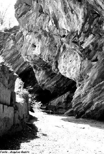
Figure 4 - View of the deposited filling
The mammals are the marsupials cf.
Didelphis albiventris, Monodelphis domestica, Marmosa cf. cinerea; the ground sloths
Catonyx cuvieri, Eremotherium lundi and Xenocnus sp.; the armadillo Dasypus sp.; the giant
armadillo Pampatherium humboldti ; the glyptodonts Hoplophorus euphractus, Panochthus
greslebini, Glyptodon clavipes; the bats Pteronotus parnellii, Tonatia bidens,
Phyllostomus hastatus, Artibeus jamaicensis, Myotis sp., Molossus molossus, Tadarida
brasiliensis, Holochilus brasiliensis; the rodents Akodon cf. cursor, Calomys callosus,
Oryzomys cf. subflavus, Oryzomys sp., Thricomys apereoides, Kerodon rupestris, Galea
spixii, Agouti paca; the carnivores Protocyon troglodytes, Cerdocyon thous, Canideo indet.
cf. Speothos or Cerdocyon, Mustelidae indet., Felis yagouaroundi and Smilodon populator ;
the Litopterna Macrauchenia cf. patachonica; the Notoungulados Toxodon sp.; the
Proboscídeos Haplomastodon waringi; the Equideos Hippidion bonaerensis et Equus neogaeus;
the Pecaris Dicotyles tajacu and Tayassu pecari ; the Camelideo Palaeolama niedae (Guérin
& Faure, 1999); the deer Mazama gouazoubira , M. americana and a large unidentified
deer cf. Blastocerus.
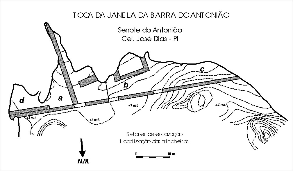
Figure 5 - Excavation plan
The gigantic Eremotherium is the
animal in most abundance by a considerable margin, followed by Palaeolama, the Equideos
and the Mastodon.
The four genera Eremotherium, Catonyx, Haplomastodon and Equus show
that this fauna is from the Upper Pleistocene. A detailed study of the evolution of each
species over time would allow a more precise date to be given.
The ecological community defined by the collection of fauna that
was present possesses some very specific characteristics. The high proportion of very
large species is testament to very abundant vegetation.
The high proportion of predators, the abundance of omnivores, the predominance of
hypsodont herbivores over the brachyodonts, and that of the large land animals adapted to
varying environments over those found only in forests, suggests a mixed landscape. Also
noticeable is the surprising absence of large rodents such as Hydrochoerides, the Tapirs
and the Primates. The ecological community of mammals during the Upper Pleistocene in the
region of Săo Raimundo Nonato is characteristic of a savannah landscape, bushy in places
and scattered with forested areas, with a much more humid climate than at present.
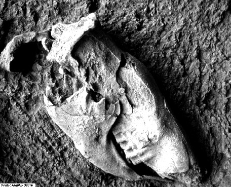
Figure 6 - The skull of the giant sloth Catonyx cuvieri
The excavations
revealed various main horizons in the distribution of remains. The preliminary analysis of
the groupings of material collected allowed us to compile, other than the dispersed bones
and artefacts, 17 concentrations made up as much of lithic material as of bone material,
or even more frequently of a mixture of both in very variable proportions. Their position
varies from the rocky wall to the limits of the shelter's expanse, and their depth varies
from 0 to 5.6 metres in sectors A (6 concentrations) and B (4 concentrations) and confirms
the East to West slope of the deposited filling. Sector C (5 concentrations) is no longer
fossiliferous beyond a depth of 2m. In Sector D, two concentrations of bones contain some
lithic pieces and there are many dispersed bones to a depth of 2.99m.
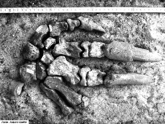
Figure 7 - The connected hand of Catonyx cuvieri
As with the taphonomic observations,
the preliminary studies of the sediment and of the current topography suggest the
hypothesis that the deposited filling has a double origin in the following ways:
- on the one hand, lacustrine sedimentation, which involves the rapid burial of animal
cadavers - the majority of which had died in the locality where they had come to drink -
and which constitutes a commomplace observation of the current natural habitat. The
discovery of various skeletons, either complete or fragmented but anatomically connected,
is evidence for this occurrence.
- on the other hand, deposition under high energy favoured by an intense karstic
circulation: some bones are extremely rounded and other reduced to the condition of
stones, sometimes mixed together with stones of rocks from outside the vicinity (quartz,
metamorphic rocks); these rocks and these fossils arrived at the site due to the karst.
Toca da Janela da Barra do Antoniăo is the most important
palaeontological site in the karst region of the archaeological area of Săo Raimundo
Nonato. Its study will allow us to place South American palaeolithic man in his
environment.
PROTECTION MEASURES
Unfortunately, these solid outcrops have been heavily damaged by the illegal
production of lime, which has been occurring for more than two decades. It is calculated
that around 50% of the surface of the solid outcrops have suffered from the impact of
human activity. The removal of blocks for the construction of simple limekilns has been
responsible for the destruction of hollows and rock paintings. This has had significantly
negative consequences for the local flora because large quantities of timber have been
felled in order to fire these kilns. At the same time, researchers have been impeded in
their access to certain areas, and thus the progress of their work has been resticted.
A complete ban on this activity was achieved only in the middle of 1999. Given that
this was an important activity for the local population, it is believed that the integrity
of the ban can only be ensured through the implementation of alternative economic projects
(Ecotourism, bee-keeping) allied to the adoption of a more effective protection and
research strategy for the region.
BIBLIOGRAPHY
Arnaud,M.B.; Emperaire,L.; Guidon,N.;
Pellerin,J. 1984. L’Aire archéologique du Sud-Est du Piauí (Brésil). Vol. 1: le milieu et les sites,
Editions Recherche sur les Civilisations, "Synthčse" n° 16, 118
p., 9 fig., 2 tabl., 5 pl., 6 cartes h.t.
Guerin,C.; Curvello,M.A.; Faure,M.; Hugueney,M.;
Mourer-Chauvire,C. 1993. La
faune pléistocčne du Piauí (Nordeste du Brésil): implications paléoécologiques et
biochronologiques. Quaternaria Nova, Roma, III, p. 303-341, 3 tabl., 8 fig.
Guerin,C.; Curvello,M.A.; Faure,M.;
Hugueney,M.; Mourer-Chauvire,C. 1996. The
Pleistocene fauna of Piauí (Northeastern Brazil). Palaeoecological and biochronological
implications / A fauna pleistocęnica do Piauí (Nordeste do Brasil). Relaçőes
paleoecologicas e biocronologicas. Fumdhamentos (Revista da Fundaçăo do Homem
Americano), Săo Raimundo Nonato, vol. 1, n° 1, p. 55-103, 8 fig., 4 tabl., e
discussőes, p. 259-336 (bilingüe inglęs/portuguęs) .
Guerin,C.; Faure,M. 1999.
Palaeolama (Hemiauchenia) niedae
nov. sp, nouveau Camelidae du Nordeste Brasilien, et sa place parmi les Lamini
d’Amérique du Sud, Geobios, Lyon, n° 32, 4,p. 629-659, 11 fig., 12 quadros.
Guidon,N.; Luz,M.F.; Guerin,C.;
Faure,M. 1993. La Toca de Janela da
Barra do Antoniăo et les autres sites paléolithiques karstiques de l’aire
archéologique de Săo Raimundo Nonato (Piauí, Brésil): état des recherches. Actes
XIIčme Congrčs international Sciences préhistoriques et protohistoriques (Bratislava,
septembre 1991), Bratislava, vol. 3, p. 483-491, 3 fig.
Peyre,E. 1993. Nouvelle découverte d’un homme préhistorique américain: une
femme de 9700 ans au Brasil. C.R. Acad. Sci. Paris, sér. II, t. 316, p. 839-842.
Rodet,J. 1997. As zonas cársticas de Săo Raimundo Nonato (Piauí, Brasil). O
carste, Belo Horizonte, vol. 9, n° 1, p. 2-7, 7 fig.