
SIGEP
Geological and
Paleontological Sites of Brazil - 066
THE FERNANDO DE
NORONHA ARCHIPELAGO
Date:
27/01/2000
FERNANDO F.M. DE ALMEIDA
ffma@uol.com.br
Departamento de Minas, Escola Politécnica
Universidade de São Paulo
© Almeida,F.F.M. 2000. The Fernando de Noronha archipelago. In: Schobbenhaus,C.; Campos,D.A.; Queiroz,E.T.; Winge,M.; Berbert-Born,M. (Edit.) Sítios Geológicos e Paleontológicos do Brasil. Published
27/1/2000 on Internet at the address http://www.unb.br/ig/sigep/sitio066/sitio066english.htm [Actually
https://sigep.eco.br/sitio066/sitio066english.htm ]
[SEE
PRINTED CHAPTER IN PORTUGUESE]
(The above bibliographic reference of author copy rights is required for any use of this article in any media, being forbidden the use for any commercial purpose) |
ABSTRACT
Fernando de Noronha is a small volcanic
archipelago in the equatorial South Atlantic, 350 km off the city of Natal, the Rio Grande
do Norte State capital, northern Brazil. The archipelago consists mainly of highly
alkaline and subsatured volcanic and subvolcanic rocks and are part of a homonymous
volcanic mountain developed along an E-W oceanic fracture zone. It encompasses an area of
18.4 km², 90% of which within the main island. There are also 18 minor islands
outcropping on a reduced island platform that truncates the volcanic mountain as deep as
approximately -100 m. The Remédios and Quixaba formations represent two major
volcanic episodes. The former one, dated Upper Miocene, comprises pyroclastics intruded by
phonolite and trachyte domes, plugs and dikes, as well as by a number of dikes showing a
varied types of alkaline rocks. Erosion processes destroyed the volcanic rocks from this
cycle, and was followed by the Quixaba Formation, during the Upper Pliocene, represented
by ankaratrite lava flows, pyroclastic rocks and rare nefelinite dikes. The archipelago
has a population of no more than 3,000 inhabitants, concentrated in the principal island,
and a small floating population of tourists and researchers. It is a Marine National Park
accessed by air flights, offering a pleasant weather, beautiful landscapes, wonderful
beaches and very clean seawater, with dolphins, turtles and many fish types. Despite of
its natural attractions, the tourism has not been stimulated, not only due to the poor
available infrastructure, but also to preserve the local ecology.
INTRODUCTION
The study of small oceanic islands has a high
scientific interest because it offers the opportunity to gather relevant information on
the nature of the oceanic crust and the processes related to its spreading. Nevertheless,
they can be pleasant sites for both tourism (Figure 3) and important ecological research.
SITUATION
The archipelago is located in the equatorial South
Atlantic at 3º 51' S and 32º 25' WG (Figure 1). The main island, also named
Fernando de Noronha, has an area of 16,4 km² representing 91% of the total area of the
archipelago, and it is surrounded by twenty other small islands, being Rata Island
(Figure 4) the largest of them (81 ha). They occur above an erosion platform, 3 to 4 km wide,
which may extend to a depth of approximately -100 m. Beyond this depth the bottoms spread
out to configure a conic mountain with a base diameter of 60 km on the ocean floor at
-4,000 m. This mountain is part of an alignment of submerged E-W volcanic highs which
compose the Fernando de Noronha Chain, along the homonymous fracture zone. At the
projection of the alignment to the Ceará coast the Ceará guyot cuts the
continental slope. In the continent, near Fortaleza, phonolite intrusives similar to the
ones encountered in Fernando de Noronha yielded an age of 30 Ma (Cordani, 1970),
suggesting that the fracture zone has also affected the margin of the continental crust.
The Rocas atoll is also a volcanic guyot of the chain leveled by the ocean and completely
covered by Lithothamnium algae reefs and sands of marine organisms.
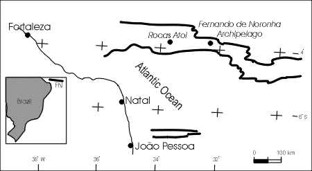
Figure 2 - Situation of the Fernando
de Noronha Archipelago at the Brazilian coast
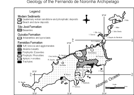
Figure 2 - Geological map of Almeida
(1955) as simplified by M.C.N. Ullbrich (1994). Abbreviations: B, bay; E, inlet; I,
island; M, hill; Pr, beach; Pt, cape
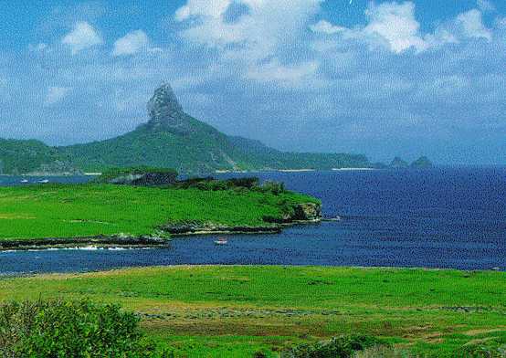
Figure 3 - Leão beach, at the E
side of the main island. Photo G. Barreto, rev. Terra, dez 1999, p. 31
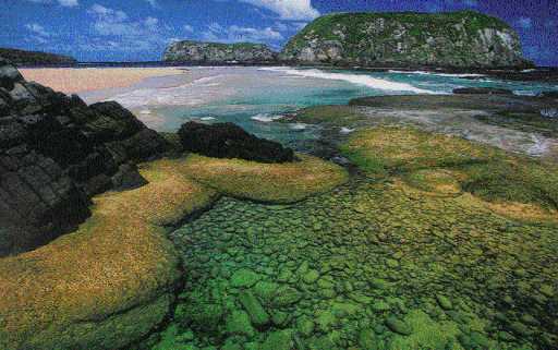
Figure 4 - Ilha Rata. Foto G.
Barreto, rev. Terra, dez 1999, p. 33
HISTORY
The archipelago was officially discovered by
Américo Vespúcio in 1503 and, in the following year, it acquired the name of a
Portuguese lord, Fernão de Loronha, to whom the Crown donated the archipelago. It was
occupied by the Dutch in 1612 and from 1635 to 1654, and subsequently by the French in
1736, later banned by the Portuguese, who fortified the main island. At the second half of
the XIX century many foreign researchers visited the archipelago, particularly after C.
Darwin’s observations (1839) on the geology, petrography, and volcanic nature of the
main island during his stay in 1832 in the historical expedition of the Beagle.
Many petrographers studied samples of rocks collected by these expeditions, mainly Smith
and Burri (1933), but Branner (1888, 1889, 1890) produced more specific descriptions about
the geology of the archipelago and the position occupied by many of the collected and
already described rocks. He made interesting observations on the calcarenites, dunes and
beaches of the archipelago. During the first half of the XX century there was no interest
on geological and petrographical studies of the archipelago, but in 1948 the Departamento
Nacional da Produção Mineral addressed there the engineer Pouchain, who published
the results of his investigations on the phosphates and calcarenites of the Rata Island.
The present author, as an engineer of the same Department, had the opportunity of travel
three times to the archipelago, to produce a geological map
(Figure 2) at the 1:15.000 scale and to
study its geomorphology, petrography, geological history, geochemistry and petrogenesis
(Almeida, 1955). More recent investigations have centered mainly on geochemical aspects,
such as the ones by Gunn and Watkins, 1978; Gerlach et al. 1987; Schwab and Block, 1985;
Weaver, 1990; and Ulbrich et al., 1994. Ulbrich (1994) described the petrography and
discussed the diversified nomenclature and classification of the archipelago rocks.
Cordani (1970) dated some of its rocks by the K-Ar method, whereas Maringolo (1994)
produced a thesis on the dikes of the principal island.
The archipelago has been subjected to several
government administrations, belonging today to the Pernambuco State.
DESCRIPTION OF THE SITE
Geographical Aspects
As an oceanic volcanic island Fernando de Noronha
shows a modest relief. In its central region, at 30-45 m over sea level, there is a low
plateau that was the result of an erosion surface carved on tuffs and volcanic breccia
under sub-aerial conditions. Hills of phonolitic rocks crops out above this plateau
(Figure 5). The highest point of the island is the Pico mountain (321 m), a curious erosion
landscape due to the fall of joint blocks (Figure 6). The airport was constructed on the
plain area between the phonolite hills. Two gentle plateaus, 150-200 m high, are composed
of an alternation of pyroclastic rocks and nefelinic ultrabasic lava (ankaratrite) flows
disposed along steps according to the gentle plunge of the flows, ending at a moderate
coastal slope or shore cliffs. The valley traces are influenced by the geological
structure; they are usually dry and start at the phonolite hills. The small islands of the
archipelago show diverse relief aspects, depending on their geological framework. The
phonolitic ones show high peaks (Frade, Sela Gineta and Cabeluda islands), whereas the
islands composed by lava flows are tabular features, as Rata and São José, or scarp
rocks (Dois Irmãos). The islands formed by calcarenites are low and show a tabular relief
(Meio and Rasa islands).
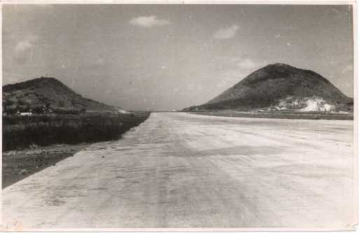
Figure 5 - Aspect of the erosion
surface of the central plateau. Mountains on phonolite. Photo F.F.M. Almeida
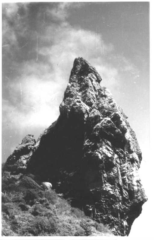
Figure 6 - Pico Mountain. Residual
relief in phonolite. Photo F.F.M. Almeida
At the south and eastern borders of the main
island, where the volcanic rocks are more exposed to the shock of the waves formed by
trade winds, there are shore cliffs; there are also abundant reefs of Lithothamnium
algae and scarce sand beaches. Sand beaches as well as active dunes are well-developed at
the northern coast. Evidence of ancient sea levels is presumable or may be recognized in
the main island. The highest one, at 30 m above present sea level, served as a base level
to the erosion of the central plateau. The other one is confirmed by the presence of
marine limestone with Lithophyllum algae at the vicinity of the port, in Santo
Antônio peninsula (Figure 7). Beach deposits containing rolled pebbles, fish remnants,
corals and other marine organisms occur in this peninsula at 7 m above sea level and as
far as 70 m from the coast line, although similar deposits elsewhere can be recognized at
12 m above the present-day sea level. The Caracas sandstone, described below, is younger
than this level, because it covers these deposits. The sandstone was formed when the sea
level was 6 m lower than the present position. At this time, extensive beaches existed in
the south and southeast of the archipelago, together with dunes of carbonate sand which
covered the present northeastern islands (Figure
8). Conglomerates and ancient sandstones
at the small Chapéu de Nordeste Island, Rata and some others lie under the Caracas eolian
sandstone.
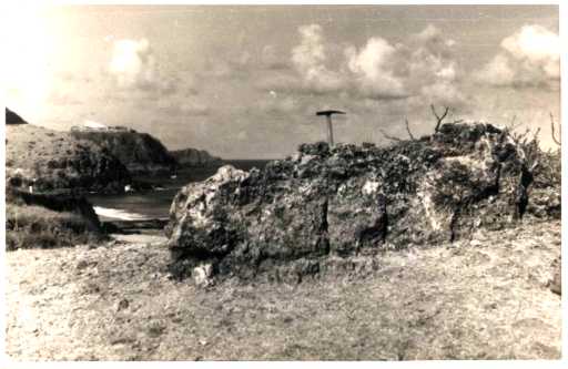
Figure 7 - Marine limestone in a
terrace 9 m above sea level. Santo Antônio Peninsula. Photo F.F.M. Almeida
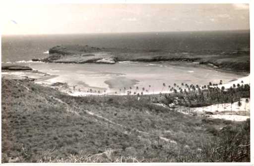
Figure 8 - Sueste Bay, a flooded
fluvial valley after the elevation of the sea level. In the bar, rests of ancient
consolidated dunes (Caracas arenite). Photo F.F.M. Almeida
The archipelago climate, of Awi-type, is similar
to the eastern coast of the Rio Grande do Norte State, with two well-defined seasons,
being the raining one from February to July. Persistent trade winds flow from ENE.
The original vegetation was almost completely
destroyed and nowadays it is restricted to the occurrence of scarce shrubby vegetation or
small arboreous and large macega, herb and graminea areas.
Regional Geology
Miocene and Pliocene volcanic rocks are exposed in
the Fernando de Noronha archipelago. The basement composed of pyroclastic rocks is
intruded by a great variety of alkaline magmatic rocks covered – after a long hiatus
– by flows of nefelinic ultrabasic rocks (ankaratrites) and their equivalent
pyroclasts. Sediments occur in the islands as a few coastal deposits: the marine ones
belong to the present cycle and the eolian sediments to the Quaternary.
The oldest rocks, recognizable in situ in
the archipelago, comprise the Remédios Formation (Almeida, 1955). They are
intrusive magmatites in pyroclasts that support the highest elevations of the central part
of the main island. It seems that the pyroclastic rocks only crop out in this island, as
irregular beds with a total thickness that may exceed 100 m. They are composed of rock
fragments of several dimensions, with blocks that may reach a diameter of one meter or
more. Among the fragments occur a variety of phonolites, trachytes and essexites. They
result of explosive paroxysms preceding and accompanying the intrusion of the phonolitic
and trachytic bodies.
In the main island eleven large independent bodies
of phonolite have been found. The one which includes the Pico crops out with a diameter of
950 m and of 1070 m at the Boa Vista Dome. Phonolite dikes, with thicknesses of several
meters, are frequent in the main island. The phonolite domes and plugs of Fernando
de Noronha were the result of endogenous crystallization and were exposed by erosion
before the generation of the ankaratritic effusions. Actually, all the magmatic rocks of
Remédios Formation are endogenous as indicated by their joints, laminar structures and
mode of occurrence. A small, but interesting, dome structure formed by rocks of trachyte
composition occur in the Leão beach, in the south coast of the island, but the more
frequent mode of occurrence of this type of rock is as great dikes.
Monchiquites, fourchites, camptonites, and other
rare types of sodium lamprophyric rocks compose the majority of the dikes which are well
observed along the shoreline of the Fernando de Noronha (Figure
9). There are also dikes of
ankaratrite, augitite, alkali-trachyte, limburgite, sanaite, olivine teschenite, porphyry
essexite, olivine nefelinite, basanite, gauteite and of other rock types. The petrographic
nomenclature of many of these dikes, as well as of other rock types in the island, is
still controversial (Ulbrich, 1994; Maringolo, 1994). The dikes strike dominantly to NW
and NE. Phonolite, trachytes and porphyritic essexites are supposed to be the oldest
magmatic rocks exposed in the island.
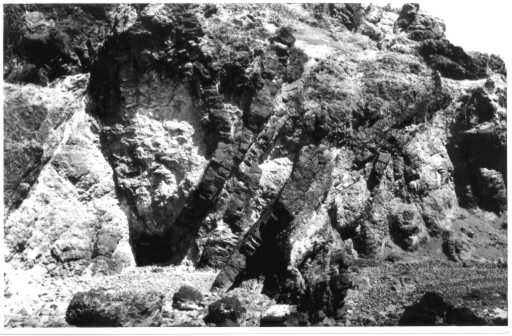
Figure 9 - Monchiquite dikes at the
shore cliff of the Atalaia Point. Photo F.F.M. Almeida
The strongly melanocratic rocks, with scarce, if
not absent, feldspars, are the youngest of the Remédios Formation. Effusive equivalents
of some of these rocks may exist at the top of the volcanic edifice, but they were
destroyed by erosion prior to the ankaratritic flows.
Special emphasis is given to the xenoliths and
ejectolites of the Remédios Formation since they may represent very deep sourced rocks of
the volcanic edifice. The clasts are dominated by rock types described in outcrops of the
main island, except clasts of nefelinic syenites and hornblende gabbros which seem to be
absent in the main island.
The Quixaba Formation (Almeida, 1955) is a
sequence of black flows of alternating ankaratrite lava and pyroclasts containing
components of the same lava. This formation rests on two step-like plateaus of the main
island; the eastern one may reach 180 m of exposed thickness above sea level. This
formation also occurs in some islands, particularly the Rata Island. The flows are
generally horizontal, but may show dips as steep as 30º to the south, concordant to the
flow direction of the lava. The flows are massive in its interior but vesicular or
amigdaloidal at the base and mainly at the top (Figure 10). Their thickness may exceed 40 m
at the shore cliff of the Sancho Bay, but it is generally just a few meters thick. Flows
of melilite ankaratrite (Figure 11), as thin as two centimeters of thickness, were seen in
alternation with lapilli-tuff containing bombs of the same material. The pyroclastic rocks
are tuffs, tuff-breccia, lapilli-tuffs and agglomerates, essentially containing components
of the flows, including isolated crystals. Angular blocks of lava may reach 2 m. Perfect
bombs and fragments of rope-like lava are not rare. They may form a chaotic group of
fragments of several dimensions, or exhibit coarse stratification, locally with fine
well-stratified beds. A striking structural feature is the Tamandaré chimney, at the
northeast edge of the main island. It has a diameter of almost 130 m and truncates the
lower flow. Its walls are of ankaratrite, with remnants of tuff and chimney agglomerate,
and crosscut by dikes. The low tide discovers the escoriaceae lava of its interior. It was
a place for escape of solutions, where calcite precipitated as perfect scalenohedral
crystals, filling fractures on breccia and agglomerates. Dikes of coarse nefelinite were
observed in a few points of the main island.
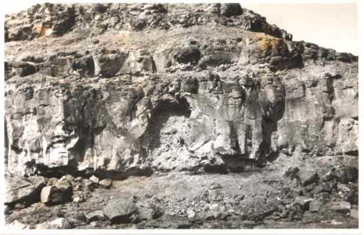
Figure 10 - Three flows of
ankaratritic lava at Caracas Point. Photo F.F.M. Almeida
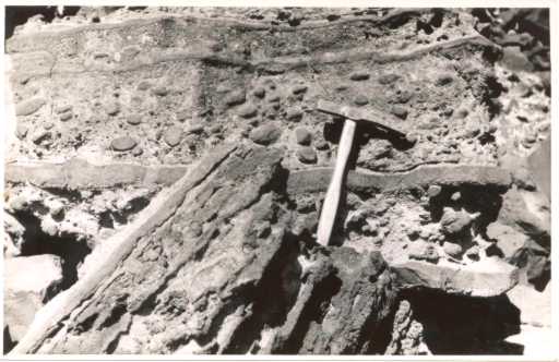
Figure 11 - Thin flows of melilite
ankaratrite containing bombs of the same rock. Shore cliff at the Quixaba beach.
Photo F.F.M. Almeida
The small São José, Cuscuz and de Fora islands,
adjoining the northern end of the Santo Antônio peninsula, are composed of the same
horizontal basanite flow showing an original thickness in excess of 25 m (Figure
12). The
ankaratrites of the point, as well as the flow at the base of the small Chapéu de
Nordeste Island, discovered during low tide, are inclined to NE. This fact led the author
to suppose the basanite to be younger than the Quixaba Formation, the reason for the name Formation
São José. It is noticeably in this flow the abundance and dimensions of dark-green
colored dunite xenoliths, almost essentially composed of olivine. Ulbrich (1994) also
refers to lherzolite and harzburgite xenoliths. Their shapes are angular to subrounded
(Figure 13) and, for some of them, the author has seen diameters up to 35 cm. They are
fragments of a voluminous rock body engulfed and transported towards the surface by the
magma. At the São José Island it can be noticed that the number and size of the
xenoliths are the highest in the lower part of the flow, as a result of a decantation
process. They possibly come from a deep and ancient zone of the upper mantle. Although the
ages obtained by Cordani (1970) for the basanite of the São José Island are older than
the rocks of the Quixaba Formation, these data may be treated with some care, because the
rock is contaminated by xenoliths of mantle olivinite. Schwabe and Block (1985) concluded
that the basanite shows geochemical relations to the Quixaba Formation. Ulbrich (1994)
also indicates that this rock should not be considered a formation, but probably
represents the climax of the Quixaba volcanism and may be petrographically correlated to
basanites of a chimney that cuts ankaratrites at the Sancho Bay, identified by Ulbrich and
Ruberti (1992).
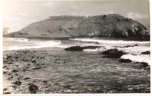
Figure 12 - Basalt flows covered by
the Caracas arenite. São José Island. Photo F.F.M. Almeida
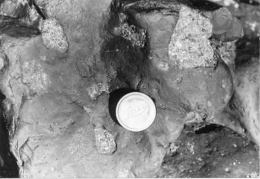
Figure 13 - Dunite xenoliths in the
basanite of the São José Island. Photo F.F.M. Al
Cordani (1970) dated by the K-Ar method rocks of
the Fernando de Noronha and Rata islands. For the Remédios Formation the oldest dated
rock is an alkali-basalt of 12.3 Ma, a minimum age for the host pyroclasts. The intrusion
of the large phonolite bodies occurred at approximately 9 Ma. For the basanite of the São
José Formation the more probable result is 9.5 Ma, obtained in two samples, however other
two indicated 8,1 and 21.9 Ma; a possible Argon loss by heating is considered to explain
the latter result. This rock is therefore prior to the Quixaba volcanism, possibly
belonging to the Remédios Formation. So, the first volcanic cycle exposed in the island
is dated Upper Miocene. The Quixaba volcanism has been processed approximately between 3.3
and 1.7 Ma, during Upper Pliocene.
The volcanism represented by the exposed rocks in
the archipelago is characterized by its strongly sodium-alkaline nature, subsaturation in
silica (there is no quartz in the rocks, the most abundant mineral of the Earth’s
crust), high degree of differentiation. The silica content varies between 34,4% (melilite
ankaratrite) and 60,8% (alkali-trachyte). The magmatic province of Fernando de Noronha is
one of the most alkaline among the oceanic volcanic islands of the world. The lighter
fractions of the magmatic differentiates were produced earlier, originating the Remédios
Formation. After an hiatus in the erosion, which may have lasted 5 to 6 Ma, the ultrabasic
volcanism of the Quixaba Formation initiated.
After the volcanism ceased at the end of the
Pliocene, an erosion cycle destroyed the external volcanic complexes and carved the island
platform. During sea level oscillations in the Pleistocene, the platform was covered by
sand and beach pebbles deposits, reefs of limestone algae and marine sand.
During the Pleistocene, when the sea level was six
meters lower than the present level, extensive sand beaches existed at the south and
southeast of the archipelago. Trade winds from SE, similar to the ones nowadays,
dislocated these sands forming dune fields that could be as thick as 20 m, linking the
area of the present Rata Island to Santo Antônio peninsula at the Fernando de Noronha
Island. Shorter dune areas, as at the entrance of the Sueste Bay, were also locally
formed, in the southeast coast of the principal island. After the recent elevation of the
sea level, a part of these sands was submerged, and the emerged ones formed the Caracas
calcarenite. This sediment, of light cream color, is almost entirely composed by limestone
grains, mainly from Corallinaceae algae. The remaining detritus are of minerals
from the magmatic rocks, except for a contamination the 25% of femic minerals where the
arenite covers an ankaratritic area. SE-blowing winds formed typical eolian cross
stratification, as Branner (1889, 1890) had already observed. The consistency is a
function of the degree of calcite cementation. At the Rata Island the Caracas arenite has
its upper part partially replaced by calcium phosphate originated from excrements of
marine birds.
PROTECTION OF THE SITE
The Fernando de Noronha Island, in the homonym
Marine National Park established in 1988, is considered by many of the visitors as the
Brazil’s most beautiful island. The population of no more than 3.000 inhabitants has
become stable and the number of tourists subjected to limits. The tourism started in the
seventies, existing nowadays daily flights to the island from Recife and Natal. However,
there are restrictive factors to the tourism. The island is far; there is an increasing
cost for permanence in the island (Maciel Filho, 1999); there is no tourism
infrastructure, just an adapted hotel using a North-American Airforce base installations
in operation during the World War II. There are a few Guest Houses in the vicinity of the
Remédios Village, at the eastern region of the island. There are some accessible roads
for vehicles, but just a seven-kilometers paved road.
The beauty of the landscape, the pleasant climate,
the morning show of the dolphins in the beach, the marine turtles, the beautiful beaches
and the sea of very clean water and plenty of fishes altogether constitute in formidable
tourism attractions. The present limitations imposed to tourism and the vigilance exerted
by the guards of the Instituto Brasileiro do Meio Ambiente e dos Recursos Naturais
Renováveis (IBAMA), of the Rotator Dolphins Project, (research on these cetacean) and
of Tamar Project (protection to the turtles' eggs) seem to be sufficient guaranties for
the adequate preservation of the ecology of the archipelago, that was strongly damaged in
the past, when the original forests were destroyed.
ACKNOWLEDGEMENTS - The author is grateful to Prof. Dr. C.D.R.
Carneiro for the evaluation of the text and figure production; to Prof. Dr. R.P. Xavier
for the suggestions on the English text; to Mabel H.C. Ulbrich for the simplified map of
the archipelago and to M. Reginato, for drafting the figure 2.
REFERENCES
Almeida, F. F. M.de 1955. Geologia e
petrologia do arquipélago de Fernando de Noronha. DNPM/DGM. Rio de Janeiro. 181 p.
(Monografia 13).
Branner, J. C. 1888. Notes on the fauna of the
Islands of Fernando de Noronha. American Naturalist,. 26, 861-971.
Branner, J. C. 1889. The geology of Fernando de
Noronha. Americal Journal of Sciences, 27,145-171.
Branner, J. C. 1890. The eolian sadstone of
Fernando de Noronha, American Journal of Sciences, 39, 247-257.
Cordani, U. G. 1970. Idade do vulcanismo no
Oceano Atlântico Sul. Instituto de Geociências e Astronomia, Boletim IGA, 1, 9-75..
Darwin, C. 1839. Journal of the researches into
the Geology and Natural History of the countries visited by H. M.S. Beagle, etc. Henry
Colburn, London. 615 p.
Gerlach, D. C.; Stormer Jr.,J. C.; Muller, P.A.
1987. Isotope geochemistry of Fernando de Noronha. Earth and Planetary Science
Letters, 85, l29-144.
Gunn, B. M.; Watkins, N. D. 1978. Geochemistry of
the Cape Verde Islands and Fernando de Noronha. Geological Society of America
Bulletin, 87, 1986 - 1199.
Maciel Filho, L. 1999. Fernando de Noronha. O
paraíso do Brasil. Viagem e Turismo, 9, 46 - 65.
Maringolo, V. 1994. Estudo petrográfico e
químico de alguns diques ultramáficos e máficos do arquipélago de Fernande de Noronha,
PE. São Paulo: Instituto de Geociências, Universidade de São Paulo. 145 p.
(Dissertação de Mestrado).
Pouchain, E. B. 1942. Recursos econômicos do
Território de Fernando de Noronha. Calcários. Fosfatos. Rio de Janeiro. DNPM/DFPM,
Boletim 83, 61-71. Rio de Janeiro.
Schwab, R. G.; Block, W. 1985. Geochemical
distribution pattern of magmatites from the Archipelago of Fernando de Noronha. Zentralblat
für Geologie und Palaeontologie. 1 (9-10), 1477 - 1483.
Smith,W.C.;
Burri,C. 1933. The igneous rocks of Fernando de Noronha. Schweiz. Min. und
Pet. Mitt.,Zurich, 13:405-434.
Ulbrich, M. N. C. 1994. Petrography of alkaline
volcanic-subvolcanic rocks from the Brazilian Fernando de Noronha Archipelago, Southern
Atlantic Ocean. Geoch. Bras. 8 (1), 21-29).
Ulbrich,M.N.C.; Maringolo,V.;
Ruberti,E. 1994. The geocheminstry of alkaline volcanic-subvolcanic rocks from
the Brazilian Fernando de Noronha Archipelago, South Atlantic Ocean. Geochimica
Brasiliensis(1994), 8(1):31-39.
Ulbrich, M. N. C ; Ruberti, E. 1992. Nova
ocorrência de rocha basanítica no Arquipélago de Fernando de Noronha. In: Congresso
Brasileiro de Geologia, 37, São Paulo, 1992, SBG. Anais, 2:
83-84.
Weaver, B. L. 1990. Geochemical of the
highly-undersaturated ocean island basalt suites from the South Atlantic Ocean Fernando de
Noronha and Tridade Contributions to Geology and Petrology(1990), 105, 502-515.