
SIGEP
Geological and Paleontological
Sites of Brazil - 056
THE STABILIZED
SAND DUNEFIELD OF THE MIDDLE SÃO FRANCISCO RIVER, BAHIA, BRAZIL
Date: 28/09/1999
Alcina Magnólia Franca
Barreto*
Kenitiro Suguio**
Paulo Eduardo De Oliveira**
Sonia Hatsui Tatumi***
* Departamento de
Geologia. Universidade Federal de Pernambuco. alcina@npd.ufpe.br.
Recife, PE.
** Departamento de Paleontologia e Estratigrafia. Instituto de Geociências –
Universidade de São Paulo. Caixa postal 11348, São Paulo, SP 05422-970. paulo@bjd.com.br
*** Departamento de Ensino Geral. Faculdade de Tecnologia de São Paulo. Tatumi@fatecsp.br
© Barreto,A.M.F.; Suguio,K.; Oliveira,P.E.; Tatumi,S.H. 1999. The stabilized sand dune field of the middle São Francisco river, Bahia state, Brazil. In: Schobbenhaus,C.; Campos,D.A.; Queiroz,E.T.; Winge,M.; Berbert-Born,M. (Edit.) Sítios Geológicos e Paleontológicos do Brasil. Published
28/9/1999 on Internet at the address http://www.unb.br/ig/sigep/sitio056/sitio056english.htm
[Actually
https://sigep.eco.br/sitio056/sitio056english.htm
] [SEE
PRINTED CHAPTER IN PORTUGUESE] (The above bibliographic reference of author copy rights is required for any use of this article in any media, being forbidden the use for any commercial purpose) |
ABSTRACT
The stabilized sand dunefield of the middle
São Francisco River represents one of the most important records of paleoenvironmental
change, mainly paleoclimatic, during the Quaternary of northeastern Brazil. Such
importance is not only a consequence of its large size (ca. 7,000 km2) and of
the thickeness of its sediments (more than 100 m), but also because it contains a record
of past climates, drier than present, which have strongly affected the evolution of its
flora and fauna.
Five geomorphological domains, which are representative of distinct
eolian dune generations, have been recognized in the area through geomorphological and
sedimentological studies. In addition, pollen analysis in peat bog sediments and
sedimentological studies of sands indicate that tropical rain forest of Atlantic and
Amazonian floristic affinities expanded in the Icatu River Valley during the Late
Pleistocene. This forest expansion could explain the existence of present-day tropical
forest enclaves with such affinities, within the modern phytogeographical domain of the
northeastern brazilian caatinga.
Therefore, the environmental protection and preservation of this
important ecosystem is of paramount importance for the maintenance of the modern and rich
biodiversity patterns found in the area, which in turn are consequence of past
environmental change.
INTRODUCTION
The inactive dunes of the middel Rio São
Francisco River, presently stabilized by vegetation, are also referred to as fossil dunes.
They represent a heritage of past climates in the area which were drier than present
(Thomas & Shaw, 1991). They generally exhibit original forms and shapes that have been
partially altered by weathering and erosion due to rainfall precipitation. Fossil dunes
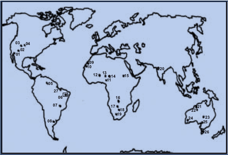
can be found in various parts of the world, in deserts or adjacent to them (Fig. 1), and
represent a source of information on paleoclimates and paleowind patterns (Melton, 1940;
Lowe & Walker, 1997).
|
| Figure 1 – Occurence of
inactive or fossil dune systems. North America: 1, Mojave Desert; 2, Arizona; 3, Colorado;
4, Nebrasca. South America: 5, Lhanos, Venezuela and Colombia; 6, São Francisco, Brazil;
7, Pantanal, Brazil; 27, Maranhão, Brazil; 8, Pampas, Argentina. Africa: 9, Mauritania;
10 Senegal; 11, Hausaland, Nigeria; 12, Mali; 13, Niger; 14, Chad Basin; Kordofan, Sudan;
16, Zaire; 17, Zambia-Angola,; 18, Zimbabue; 19 Kalahari. Asia: 20, Thar Desert. Oceania:
21, Northwestern Australia; 22, Gt. Sandy Desert; 23, Simpson-Malle-Strezelecki Desert;
24, Western Australia; 25, Southern Australia; 26 Tasmania. (Modified from Thomas &
Shaw, 1991) |
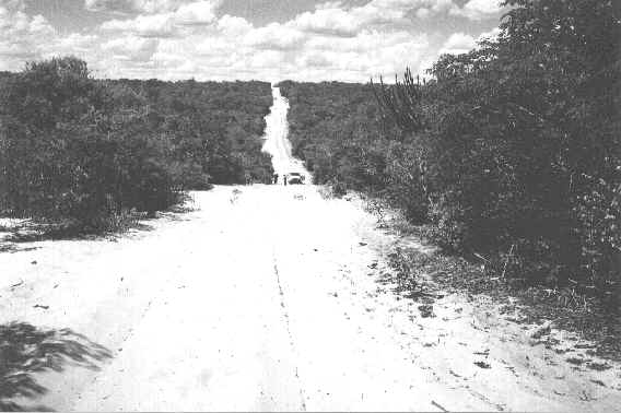
The inactive dunefield area presented in this
study is located between the towns of Barra and Pilão Arcado, State of Bahia, have the
São Francisco River and the Serra do Estreito mountain chain as its eastern and western
geographical limits, respectively.
The barren landscape and consequently its low human population density are factors that
favor and facilitate environmental protection measures in the area. In addition, the
studied area is a suitable site for paleoenvironmental and paleoecological research that
can contribute to a better understanding of its present day floristic and faunal
biodiversity patterns.
LOCATION
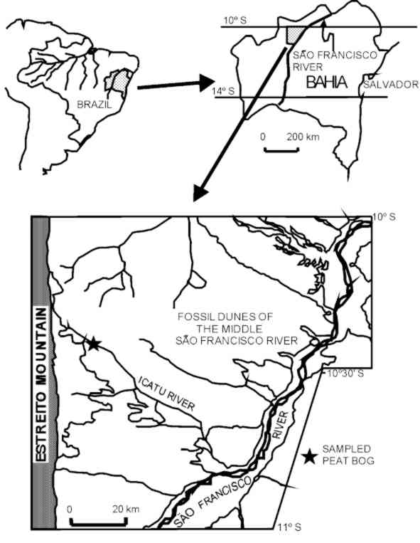
This stabilized dunefield, located 700 km
away from the capital city of Salvador, occupies the NW portion of the State of Bahia,
between 10000’e 11000’S latitude and 42030’
e 43020’W longitude (Fig. 2), thus belonging geographically to the
municipalities of Barra, Pilão Arcado and Xique-Xique. The area can be reached by the
BR-324 highway, from Salvador to Juazeiro, and later by the BR-235 highway to Pilão
Arcado.
The sandy nature of the terrain, the abscence of paved roads and the
precarious infra-structure of the region restrict access to four-wheel or animal-traction
vehicles.
|
Figure 2 – Map
of study site |
HISTORY OF SCIENTIFIC STUDIES
The sand dunefield was referred to as
"the little Sahara along the São Francisco River"by Williams (1925). According
to this author, the São Francisco River was the source for its sands, which were
transported during dry climates by eolian activities and later stabilized by vegetation.
Moraes Rego (1926) established the Vazantes Formation, which included
the alluvial and eolian deposits of the dunefield bordering the São Francisco River.
The first paleoclimatic considerations about the area are those of
Domingues (1948), who attributed its origin to the supposedly pronounced aridity during
the last glacial period of the northern hemisphere. According to this author, the São
Francisco River would have acquired a senile phase in the Pleistocene characterized by
intense sedimentation, synchronous with the formation of a wandering meander system due to
its reduced capacity for sediment transport. The latter, was in turn, believed to be
insufficient to carry all the sedimentary load of the river.
According to King (1956), the eolian sands of the middle São Francisco
River were the result of the post-Velhas erosive cycle, which formed the Plio-Pleistocene
applanation. King believed that the main river had a NW flow into the Tocantins River, but
it was brought to its modern position by fluvial piracy.
This stabilized or inactive dunefield was interpreted as
geomorphological evidence of a climate drier than present, which according to Tricart
(1974) persisted during the Last Glacial Maximum ca. 18,000 years BP. He hypothesized that
the region was characterized by endorheic drainagem pattern, which flowed into a huge lake
and that the present exorheic pattern became established at the end of the last glaciation
ca. 12,000 years BP.
Goudie (1983), based on Tricart (op. cit.) included this
inactive dunefield in a world-based map of areas subjected to eolian activities during the
Last Glacial Maximum. Schobbenhaus et al. (1984) also accepted Tricart’s
interpretation (op. cit.) and suggested that this area represents "the one and
only example of dune formation during the desert-like environment of the Quaternary of
Brazil".
According to Costa (1984), the parabolic and longitudinal dunes
reaching up to 50 m in height were deposited by SE and E winds and that its sands were
originated from the São Francisco River and barred by the Serra do Estreito mountain
chain, which acted as topographic barrier, thus limiting its westward expansion. Costa
(op. cit.) also suggested that during the final stages of the last glacial cycle of the
northern hemisphere, moist climates allowed the shift from an endo- to exorheic drainage
pattern. Thus, the dunes would have been covered by the vegetation, thus becoming
stabilized by a very unstable equilibrium. This environmental unstability prompted this
author to suggest the incorporation of this area to the National System of Conservation,
with assured permanent and compulsory preservation, which could be facilitated by the
inexpressive pattern of human occupation, which is attributted to the local edaphic and
hydrological constraints.
Rodrigues (1991) studied the herpetofauna and identified new genera and
species of lizards completely adapted to subterraneous life in the sands and similar to
those reported for australian and south african deserts. According to this author, these
animals had a common ancestral species whose distribution range was isolated by a
geographical barrier provided by the São Francisco River, thus allowing the rise of three
new species.
Barreto & Suguio (1993) obtained sedimentological data that
indicates that the São Francisco River had been the only source for the sands of
dunefields, thus contradicting the ideas of Costa (1984). These authors compared the
present sediment load of this river to the estimated volume of eolian sand that exists
between the localities of Barra and Pilão Arcado and concluded that, at least, 100,000
years would have been necessary for its accumulation.
SITE DESCRIPTION
Climate
According to the Köppen system the climate of
the area can be classified as Bswh (semi-arid and hot with a 7-8 month long dry season).
Annual average precipitation ranging from 400 to 800 mm is restricted mainly to the period
of October to March. According to Nimer (1977, 1989), average annual temperature of
coldest month is higher than 180C and average of annual mean temperature is not
higher than 270C. The seasonal fluctuations of wind patterns are associated to
the atlantic equatorial and to the atlantic tropical air masses in the winter, whereas in
the summer they are associated to the continental equatorial air mass. Wind velocities,
measured at the Meteorological Station at Barra and Remanso, between the years of
1928-1942 and 1972-1976 are relativelly low, ranging from 1.8 to 3. 1 m/s (Pessoa, 1979;
Silva, 1974).
Vegetation
The poorly developed sandy soils of the
dunefield and the prevailing semi-arid climate is conducive to caatinga vegetation on the
landscape (Jacomine et al., 1976).
Caatinga plant formation can be subdivided into hyperxerophytic (shrub
caatinga) and hypoxerophytic (arboreal caatinga) caatinga categories. Hyperxerophytic
caatinga is preferentially well developed adjacent to the São Francisco RiverValley.
Population density of shrubs is variable and imparts an open and scrub-like aspect to the
landscape. Typical plant taxa of this vegetation type are Cnidoscolus phyllacanthus,
Euphorbia and myrtaceaeous shrubs, spiny bromeliads and cacti (Opuntia
inamoema). The hypoxerophytic caatinga is well represented on the eolian deposits and
resembles a transitional vegetation type between the caatinga (sensu lato) and dry
deciduous forest. This vegetation type is characterized by the presence of trees of Pseudobombax
(Bombacaceae), Maytenus (Celastraceae), some arborescent cacti (Pilocereus
sp., Cereus sp.).
A gallery forest containing true caatinga elements such as the Copernicia
cerifera and other palm species borders the São Francisco River. Also present in this
vegetation type is the herbaceous Bromelia sartorum. On the margins of the
few tributaries of the São Francisco River draining the dunefield area and on the
interdune lowlands Mauritia vinifera palms form dense groves on the hydromorphic
soils, on which the aquatic taxon Typha sp. becomes abundant.
Geomorphology and Geology
The studied area is located in the peripherical
depression of the middle São Francisco River, with elevation ranging from 400 to 800 m
(IBGE, 1977).
The features related to eolian sedimentation were analysed according to
sedimentological and morphological characteristics, post-depositional modifications and
paleowind patterns (Barreto, 1996). This study allowed the division of the area into five
geomorphological domains (Table I, fig. 3,4,5).
Geomorphic Domains |
Mean altitudes (m) |
Chief
Physiography |
Density and
preservation of dunes |
Processes and/or
agents |
Most important
deposits |
1 - fluvial |
400-440
480 e 520 |
Flat |
- |
Fluvial |
Fluvial |
2 – sand sheets |
400-440 |
Flat |
- |
Eolian with intense
fluvial and pluvial reworking |
Blanket shaped with
diffuse fluvial channels |
3 – dunes with
distinct morphology |
400-480 |
Strongly undulated |
High density and good
preservation |
Eolian with fluvial
and pluvial reworking |
Varied and distinct
parabolic dunes |
4 – dunes with
tenuous morphology |
440-600 |
Strongly to moderately
undulated |
Changeable density and
preservation |
Eolian with fluvial
and pluvial reworking |
Tenuous or distinct
undefined dunes |
5- dissipated dunes |
600-680 |
Slightly undulated
tableland |
Low |
Eolian with intense
fluvial and pluvial reworking |
Tableland |
|
Table – 1. Main
characteristics of the geomorphological domains (Barreto, 1996). |
 |
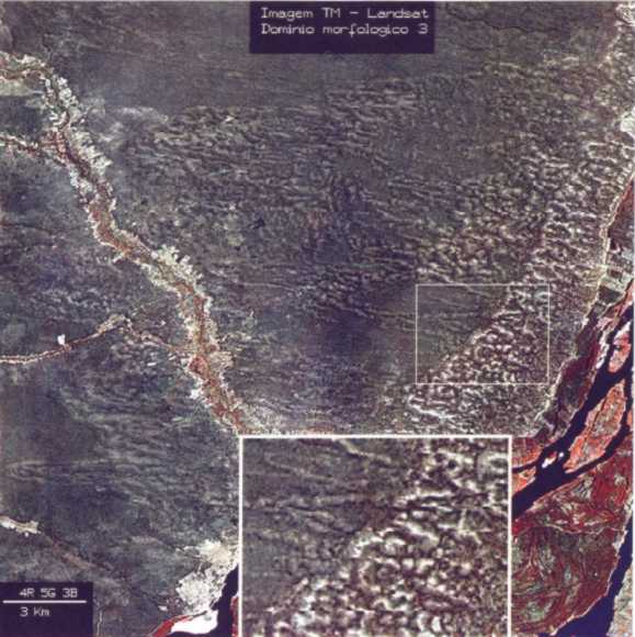
| Figure 3 – Simplified map
of geomorphic domains (Barreto, 1996) |
|
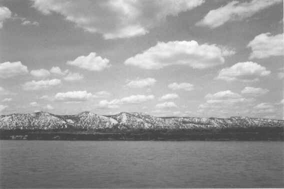
| Figure 4 – Geomorphic
domain 3. General aspect of the dunes adjacent to the São Francisco River, showing the
undualted physiography of the region, sand fans formed by pluvial erosion and
shrub-caatinga vegetation. |
|
Figure 5 –
Geomorphic domain 4. General aspect of the local physiography showing the moderately
undulated terrain covered by dense arboreal caatinga. Note the white sands next to the
São Gonçalo swamp. (Icatu River). |
Each geomorphological domain contains an area
with similar morphological characteristics, originated at the time of sedimentation and of
the post-depositional modifications which can contain more than one stage of dune
generation. These premisses were considered and provided a guideline to the sampling of
sands for sedimentological and thermoluminescence dating analyses.
The height of the dunes is variable and ranges between 5 and 10m up to
50 to 60 m. Mean height varies between 15 and 25 m. Horizontal dimensions of dunes range
from 1 to 3 km but some some parabolic dunes reach lengths greater than 10 km. According
to the classification system proposed by Pye (1993) a large number of variable simple and
compound parabolic dunes was found. The most common dune shape types found in this study
are nested, echelon or rake-like, digitate and superimposed (Fig.6). This great diversity
of shapes of parabolic dunes can be attributed to the variability of the paleowinds at a
regional scale. The paleowinds responsible for the formation of these dunes are
characterized by two main wind direction modes (NW and W), with a dispersion rate of 530
(Barreto, 1996).
|
Figura 6 –
Geomorphic domain 3, with predominance of nested, compound, eschelon parabolic dunes
(detail). On the right hand lower corner, the São Francisco River at Xique-Xique, and its
tributary, the Icatu River. |
The overwhelming size of the dunes can be
attributed to the combined effect of high energy (velocity) of the winds, couple to the
abundant supply of sands and to the local resistence to migration imposed by obstacles
such as the vegetation and rock outcrops.
The present state of knowledge on this system has generated various
doubts regarding the relationship between paleowind patterns and the different dune
generations. However, from the Late Pleistocene until Present, at least three main
episodes can be distinguished:
a) From 28,000 to 15,000 years BP - During this time interval the
main parabolic compound and nested dunes were generated. These were charaterized by shapes
varying from "V" shaped elongated to simple elongated parabolic forms. The winds
had a SE-NW direction, with single modal regimes and had a low dispersion rate.
b) From 9,000 to 4,000 years BP - During this period, compound and
nested parabolic, as well as superimposed, digitated, rake-like and nested dunes with
predominantly closed "U" shaped forms were generated. These reflect a E-SE to
W-NW paleowind direction. Although, the latter had a single modal distribution, these
winds favored higher dispersion rate of the sediments, which enhenced the occurrence of a
variety of parabolic forms.
c) From 4,000 to 900 years BP - A new generation of dunes,
superimposed on the older ones, was generated. These dunes were composed primarily of
nested, elongated and asymetrical in shape. They were smaller than those of the previous
generation and reflected paleowinds with SE to NW direction and lower dispersion rate.
The three dune generations above mentioned are
found superimposed on each other on the north central portion of geomorphological domain
4. The last two dune generations, mainly those found in the domain 3, along the São
Francisco River, suggest that the main and almost only source of eolian sands to this
system was the river, a hypothesis strongly supported by sedimentological analyses of the
sediments.
Grain size, morphoscopic and mineralogical studies have revealed high
rates of compositional and textural maturity, thus suggesting them to be polyclic sands.
Seven profiles of vertical electrical surveys, combined with the
topographic caracteristics of the area, suggest that basement of the dunes is located at
140 m below the present base level, represented by the São Francisco River. These studies
also revealed that eolian sand thickeness range from 50 to 150 m.
Under the dunes there is an important aquifer, which has not yet been
utilized due to the low human population density in the area but which represents a
potential source of water supply for domestic and farming purposes.
Thermoluminescence dating of 42 dune sand samples have indicated
important phases of eolian activity from 28,000 to 900 years BP, which were intercalated
by quiescence or periods of dune stabilization (Fig.7). The lack of dates ranging from
10,500 to 9,000 clearly suggest that, during the onset of the Holocene, eolian activity
was reduced on the landscape. On the other hand, the high frequency of ages ranging from
4,500 to 1,700 years BP indicate an increase in eolian activity in the area. The
thermoluminescence and radiocarbon dates were compared by using contiguous samples. The
dates yielded by the two different methods were statistically similar.
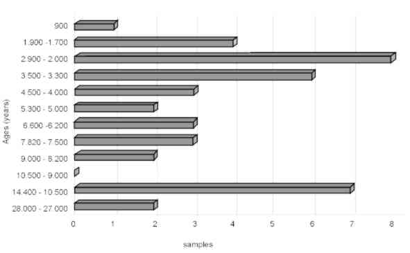 |
Figure 7 – Graphic
representation of the samples dated by Thermoluminescence. |
The majority of thermoluminescence dates from
eolian sands are in close agreement with a paleoclimatic scenario of increasing aridity,
as indicated by the rise of caatinga and cerrado vegetation in the last 4,000 years BP.
This scenario is also supported by the occurrence of 12 sites, within an area of
approximatelly 1,000 km2, in which charcoal fragments were found dispersed in
the dunes and dated by the 14C method (Barreto et al. 1996). Increase in
aridity during the Late Holocene could possibly be related to climatic phenomena of long
duration (decades to centuries) of the El Niño type as it has been suggested for other
areas in Brazil (Meggers, 1994; Turcq et al., 1998).
Palynology and paleoclimates
A palynological study was conducted in peat bog
sediments of the Icatu River Valley, the main tributary of the São Francisco River in the
study area. The studied locality known as Saquinho lies at 10024’S and 43013’W.
The sediment core yield a basal age of 10.900 anos years BP (De Oliveira et al.,
1997). This study, which represents the first palynological study in the semi-arid
caatinga region of Brazil, allowed the authors to identify five distinct climatic and
vegetational phases over the last 11,000 years.
At the end of the Pleistocene and onset of the Holocene, more humid and
colder climatic conditions permitted the expansion of gallery tropical forest in the
floodplains of the dunefield system. Caatinga vegetation was less conspicuous on the
landscape from 11.000 to 8,900 years BP but some of its botanical elements have always
been present in the ecological profile of the sediments. This vegetation type became
prevalent from 4,240 years BP to the present.
The palynological study of De Oliveira et al. (1999) together
with thermoluminescence data do not give any support to the simplistic hypothesis of
Tricart (1974), who believed that this extensive dunefield system was formed during the
Last Glacial Maximum, between 18,000 and 14,000 years BP. In the last 30,000 years, eolian
reworking of the dunes appear to have been more intense in the Holocene rather than during
the Late Pleistocene. Moreover, the great thickeness of the eolian sand deposits suggests
that this system was probably formed ca. 2 million years ago or even in the Late Tertiary.
Finally, the palynological analyses suggest that in the Late
Pleistocene a large expansion of tropical rain forests with Atlantic and Amazonian
floristic affinities were succesfully able to colonize the Icatu River Valley. Such event
could explain the modern botanical affinity of the controversial tropical forest enclaves
found presently within the caatinga phytogeographical and climatic domain. These forest
enclaves have long been known to represent disjunct distribution of amazonian and atlantic
forests in northeastern Brazil and to represent evidence of important paleoclimatic events
(De Oliveira et al., 1999)
ENVIRONMENTAL PROTECTION
The stabilized dunefield system of the middle
São Francisco River, in the State of Bahia, represents a very important record of
geomorphological, geological, climatic and biological evolutionary change, which are in
large part is due to past paleoclimatic variability during the Quaternary in northeastern
Brazil. On the other hand, faunal and floral diversities reflect the dynamic physical
scenario found in this system.
Due to high susceptibility to erosion of these sandy soils, human
occupation in the area must be prevented for it may lead to a complete degradation and
deterioration of these ancient sand dune systems. These inturn could lead to irreversible
hydrological and biodiversity changes. There is absolutely no doubt that increased human
densities would exacerbate the ongoing geological processes. The nutrient poor soils used
by the small local human population of the area, the subsistence problems encountered by
them and the difficulties in accessing the region favor the politics of permanent
environmental preservation.
Therefore it is essential that the vegetation, which protects the
landscape against erosive forces and eolian activity, should be protected. Moreover, the
native vegetation which controls the prevailing hydrological regime is not only a source
of food to the caatinga animals but also provides ecological habitats for a very endemic
and poorly still studied fauna.
BIBLIOGRAPHY
Barreto, A. M. F. 1993. Estudo morfológico e
sedimentológico da porção norte do mar de areia fóssil do médio Rio São Francisco,
Bahia. Inst. de Geociências, Universidade de São Paulo, São Paulo, Dissertação de
Mestrado, 98p.
Barreto, A.M. F. & Suguio K. 1993. Considerações sobre a
idade e a paleogeografia das paleodunas do médio Rio São Francisco, Bahia. In: Congresso
da Associação Brasileira de estudos do Quaternário - ABEQUA, IV, São Paulo, 1993. Resumos
Expandidos, p. 11.
Barreto, A. M. F. 1996. Interpretação paleoambiental do
sitema de dunas fixadas do médio Rio São Francisco, Bahia. Inst. de Geociências,
Universidade de São Paulo, São Paulo, Tese de Doutoramento, 174 p.
Barreto, A. M. F.; Pessenda, L C.; Suguio, K. 1996. Probable drier
Holocene climate evidenced by charcoal bearing middle São Francisco river paleodunes,
state of Bahia, Brazil. Anais da Academia Brasileira de Ciências. 68:1. 43-48p
Costa, M. I. P. 1984. Caracterização e avaliação dos ambientes
dunares nas folhas SA 24 Fortaleza; SB 24/25 Jaguaribe/Natal e SC 23 Rio São Francisco.
Boletim técnico do Projeto RadamBrasil, Série Geomorfologia, 187:84-87.
De Oliveira, P.E.; Barreto, A.M.F.; Suguio, K. 1997
Paleovegetação e paleoclima do Quaternário tardio da caatinga brasileira: o campo de
dunas do médio rio São Francisco, Bahia. In: Congresso da Associação Brasileira de
Estudos do Quaternário ABEQUA, VI e Reunião sobre o Quaternário da América do Sul.
Curitiba, PR. Resumos Expandidos.171-175.
De Oliveira, P.E.; Barreto, A.M.F.; Suguio, K. 1999 Late
Pleistoceno/Holocene Climatic and Vegetational History of the Brazilian Caatinga: the
fossil dunes of the middle São Francisco River.Paleogeography, Palaeoclimatology,
Palaeoecology vol 152 (3-4) 319-337.
Domingues, A. J. P. 1948. Contribuição a geologia do sudeste da
Bahia. Revista Brasileira de Geografia, 10:255-289
Goudie, A. 1983. Environmental Change. 2 ed.
Oxford, Clarendon 258 p.
IBGE. 1977. Geografia do Brasil. Rio de Janeiro,
SERGRAF/IBGE vol. 2.
Jacomine, P.K.T.; Cavalcanti, A.C.; Ribeiro, M. R.; Montenegro, J.
O.; Burgos, N. 1976. Levantamento Exploratório - Reconhecimento de solos da margem
esquerda do Rio São Francisco, Estado da Bahia. Boletim Técnico EMBRAPA, n0
38, 404 p.
King, L. G. 1956. A Geomorfologia do Brasil Oriental. Revista
Brasileira de Geografia, 18(2):147-265.
Lowe, J. J. & Walker, M. J. C. 1997. Reconstructing
Quaternary Environments. London, Longmam Group Ltd. Londres, 446p.
Meggers, B.J. 1994 Archeological evidence for the impact of
mega-niño events on Amazonia during the past two millenia. Climatic Change, 28: 321-338.
Melton, F.A. 1940. A tentative classification of sand dunes its
application to dune history in the Southern High Plains. Journal of Geology, 48(2):113-145.
Moraes Rego, L. F. de. 1926. Reconhecimento geológico da parte
occidental do Estado da Bahia. Boletim do Serviço Geológico e Mineralógico,
17:33-54.
Nimer, E. 1977. Clima. In: Geografia do Brasil - Região
Nordeste. Vol. 2 IBGE. Rio de Janeiro.
Nimer, E. 1989. Climatologia do Brasil. IBGE. Rio de
Janeiro, 421p.
Pessoa, M. D. 1979. Inventário Hidrogeológico Básico do
Nordeste. Folha 18. São Francisco NE. SUDENE, Série Hidrogeologia, Bol. nº 59,
Pye, K. 1993. Late Quaternary development of coastal parabolic
megadune complexes in northeastern Australia. Spec. Publ.
of the Int. Ass. Sediment., 16:23-44.
Rodrigues, M. T. 1991. Herpetofauna das dunas interiores do Rio
São Francisco, Bahia, Brasil. Papéis Avulsos de Zoologia, 37(19):285-320.
Schobbenhaus, C. F. 1984. Geologia do Brasil. Texto
explicativo do mapa geológico do Brasil e da área oceânica adjacente incluindo
depósitos minerais, escala 1: 2.500.000. Brasília, MME/DNPM, 501 p.
Silva, A.B. 1974 Inventário Hidrogeológico Básico do Nordeste.
Folha 23 São Francisco SE. SUDENE, Série Hidrogeologia, Bol. nº 50, 160 p.
Thomas, D.S.G. & Shaw, P.A. 1991 "Relict" desert
systems: interpretations and problems. Jounal of Arid Environments, 20:1-14.
Tricart, J. 1974. Existence de périodes seches au Quaternaire en
Amazonie et dans les régionas voisines. Revue Geomorphologie Dynamique, 4:145-158.
Turcq, B. Sifeddine, A.; Martin, L.; Absy, M.L.; Soubies, F.
Suguio, K.; Volkmer-Ribeiro, C. 1998. Amazonia rainforest fires: A lacustrine record of
7,000 years. Ambio, 27:139-142.
Williams, H. E. 1925. Notas geológicas e econômicas sobre o vale
do Rio São Francisco. Boletim do Serviço Geológico e Mineralógico, n0
12, 56 p.