SIGEP
Geological and Paleontological
Sites of Brazil - 032
THE FOSSILÍFEROUS PLACE OF
PIRAPOZINHO
(SĂO PAULO STATE, BRAZIL)
Date:
23/09/1999
JOSÉ MARTIN SUÁREZ
soniara@prudente.unesp.br
UNESP – Presidente Prudente
Rua Roberto Simonsen, 305 – Centro Educacional
19060-900 – Presidente Prudente – SP
© Suarez,J.M. 1999. The fossiliferous place of Pirapozinho (Săo Paulo state, Brazil). In: Schobbenhaus,C.; Campos,D.A.; Queiroz,E.T.; Winge,M.; Berbert-Born,M. (Edit.) Sítios Geológicos e Paleontológicos do Brasil. Published
23/09/1999 on Internet at the address http://www.unb.br/ig/sigep/sitio032/sitio032english.htm [Actually
https://sigep.eco.br/sitio032/sitio032english.htm]
[SEE
FINAL PRINTED CHAPTER IN PORTUGUESE]
(The above bibliographic reference of author copy rights is required for any use of this article in any media, being forbidden the use for any commercial purpose)
|
ABSTRACT
The paleontological research in the western of the Săo Paulo State, in the region kwown as Pontal do Paranapanema, at the center of Paraná Basin, although noticed, fossils finding sometime, they do not have had a sistematic researching until some years ago. During the field work with the purpose of the regional geology surveying, it was discovered by the autor an extraordinary fossiliferous bed containing many quelonious, carophytas, ostracoda, dinosauria and fish rest in the branch line of the Sorocabana Railroad (today disabled), between municipalities of Pirapozinho and Presidente Prudente. With the branch extintion, the retreat of marks, soil erosion and the vegetation take over of the site, hiding the local fossils to curious people, dropping the spoil was submitted.
INTRODUCTION – In the 1950s the old Sorocabana Railroad led
off the accomplishment of a project that would take a road to Dourados (Mato Grosso do
Sul), crossing the Pontal do Paranapanema. The work demanded cuts for the passage of the
rails, thus providing the opportunity to examine the sedimentary structures in the
sections. The railroad worked until some years ago when it was disabled, just remaining
its bed. In one of those cuts, on km 736,1 (corresponding to the coordinates
lat.22°13’08" S; long. 51°25’59" W and altitude 402,96 meters)
located, practically, in the boundary between the municipal districts of Presidente
Prudente and Pirapozinho (Figure 1), a great amount of fossils with astonishing predominance of
quelonian material appeared (Figure 2). The deposit extends for as far as km 734. The
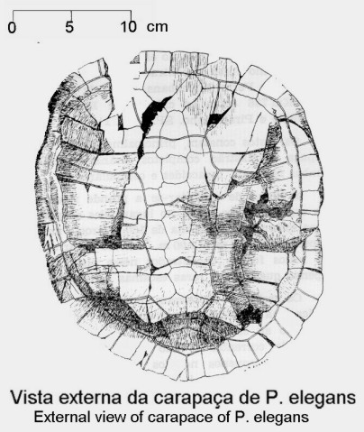
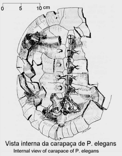
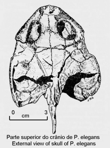
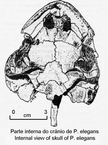
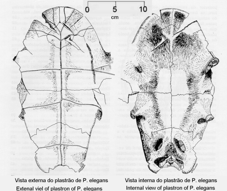
quelonious, mostly of the species Podocnemis elegans and rarer specimens of
Roxoquelis wanderlii, are distributed along those two kilometers. However, in some places
they are piled up forming a structure somewhat imbricate (Figures 3 and 4). Besides the
quelonian material we can find along the outcrop remains of reptiles, lamelibranquies,
carophytas and crustraceans (ostracods), all of them already studied or being studied by
several researchers (Mezzalira, 1966, 1973), (Suárez, 1968, 1973), (Suárez and
Campos, 1995) and (Dias-Brito et al., 1998). The rocks where fossils were found are in its
majority fine sandstones and silty sandstone’s, exhibiting chain structures, well
compacted and frequently presenting calcium carbonate cement.
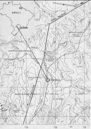
Figure 1 -
Fossils site localization (Pirapozinho, Săo Paulo state).
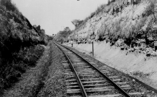
Figura 2 - General view of the fossils site at Ramal de Dourados(Sorocabana
Railroad, today extint).
Figure
3 - Fossils
disposition at km 736,2, showing some exemplars of Podocnemis
elegans.
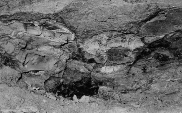
Figure 4 - Fossils disposition detail at the site.
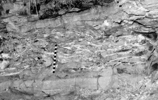
GEOLOGY – Illustration
5 gives us an idea of the nature
and disposition of the layers at mark 736,1, explained as follows:
- Silt sandstone, very fragmented, with calcium carbonate cement, with fossil remains
of ostracods, color 10YR7/2, 2 meters thick.
- Silty sandstone with interlayed claystone and siltstone fragments, and with indefinite
fossil remains, 1,5 meters thick.
- Very fine sandstone with siltstone fragments and claystone, calcium carbonate cement
matrix, fossils (ostracods, carophytas); color 10YR7/4, 1,8 meters thick.
- Very fine sandstone, loamy, very fragmented, color 10YR5/2, 0,5 meters thick.
- Fine sandstone, well compacted, color 5YR, 7, 5/4, 1,75 meters thick.
- Fine to medium sandstone, not very compacted, color 5YR 6/4, 1,2 meters thick.
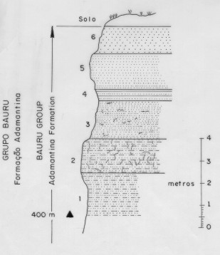
Figure 5 - Geological and lithological section in
km 736.1.
These rocks belong to the Bauru Group, Adamantina formation, upper
Cretaceous, extending through the whole western plateau in Săo Paulo State and part of
Minas Gerais State, in the Paraná Basin. In a well opened in Pirapozinho, the Group is
230 meters thick. The outcrops in surface are much more restricted than the ones depicted
in the geological map of the State of Săo Paulo because they are covered by Cenozoic
sediments, so that the outcrops in the field are just visible in the hillsides, slopes,
talwegs and river banks. The Bauru Group rocks are very fossiliferous especially the
Adamantina and Marília formations. They are lithologically represented by sandstone,
siltstones, claystones and conglomerates of fluvio-lacustrian origin and, as suggested by
the examination of the sedimentary structures and the nature of the fossils, have been
deposited under a hot and humid climate. The strata are very resistant to erosion,
frequently due to the presence of calcium carbonate cement or siliceous cement.
STRATIGRAPHY - We won’t linger on an
exhibition of the stratigraphy, for this is not the objective of this work. For more
details the reader should refer to the existing bibliography on the subject.
In the area studied (Western Săo Paulo State), there are rocks
belonging to the Bauru Group (Cretaceous) and Cenozoic ones.
The Bauru Group, occupying the central part of the Paraná Basin,
reaches a thickness of 300 meters. From base to top, there are the formations Caiuá,
Santo Anastácio and Adamantina. The Marília formation is not present in the area.
CAIUÁ FORMATION - This formation was studied by
several authors, among them, Washburne (1932), Scorza (1952), Freitas 1973, Suárez (1973)
and Landim et al. (1980). It is constituted by fine to medium sandstone, color ranging
from violet to dark brown, with large cross-bedded layers. A thin coat of iron oxide
covers the grains of quartz. The contact Santo Anastácio/Caiuá Formations is
transitional, the latter only visible in the banks of the Paraná and Paranapanema rivers
and in some of their tributaries. It is verified, by examination of well samples, that is
extends in subsurface through States of Săo Paulo, Paraná and Mato Grosso do sul.
Fossils were not found except for ichnofossils footprints. Leonardi (1977) informed the
existence of two ichnofaunas attributed to a Teropoda and with restrictions to Therapsida
in Cianorte (Paraná State). Its maximum thickness in the area is of around 70 m in
Presidente Epitácio (Săo Paulo State).
With regard to the depositional environment some authors opt for the
aqueous and others for the eolic. This author opted for a mixed environment, because of
the presence of mica (muscovita), the state of the surface of grains (Suárez, 1973) and
still, for the large cross-bedded layers.
SANTO ANASTÁCIO FORMATION - It is composed of fine to
medium sandstone, poor in sedimentary structures and presenting layers of clay of brown
color of small thickness, as well as sandstone nodules of irregular shapes cemented with
calcium carbonate. It has a variable thickness in the area in the order of 70 m. The
deposition environment must have been after Soares and Landim (1980), "a fluvial
transitional model from meandering to anastomosed essentially sandy". In some
outcrops of the Group found in the area we can observe an abrupt change of lithology in
relation to the Adamantina’s Formation basal part, indicating some hiatus in
sedimentation. Its fossiliferous content is restricted up to now to the presence of
Characeas.
ADAMANTINA FORMATION – This formation has a
larger distribution in the area and is clearly distinguished from the two previous ones
because of the changes of lithofaces either horizontally as vertically. The outcrops show
a great variation of sedimentary structures of hydrodynamic nature showing, in some
outcrops, rhythmicity in the disposition. Grooved crossed bedding, ripple drift marks and,
in some levels, paleochannels and claystone lenses are frequent. In general the sandstone
is fine to medium of rosy color, sometimes with small millimetric nodules of claystone and
siltstone. Frequently the sandstone strata are cemented with calcium carbonate, clayey and
in other cases with siliceous cement. This last cementation type is more frequent in the
proximity of the Paranapanema River, although it can also be found distant from these
areas.
The existence of an intraformational layer (altitude 420 meters) of
variable thickness of a hard compact microconglomerate, with carbonate cement and cross
bedding should also be mentioned. Such layer was recognized in areas which were far apart,
as in the area of Uberaba (Minas Gerais State) and in several municipal districts in this
area. It contains many fossil remains, all of them evidencing transport.
Most of the fossils in the Bauru Group are found in the Adamantina
Formation, most frequently in the medium and upper parts, being remains of mollusks, fish,
quelonious, crocodilydeos, dinosaurs, sauropods, carophytas (Arid, 1967; Mezzalira, 1974;
Suárez, 1968, 1973, 1998; Dias-Brito et al., 1998), indicating a hot, humid climate, with
arid and semi-arid periods or phases. The environment of deposition of this unit is
considered, for its researches, as having been fluvio-lacustrine.
The Adamantina Formation age, after Dias-Brito et al. (1998), by the
study of calcareous microfossils, would be located in the late to middle Cretaceous and
the interval suggested Post-Cenomanian to the Pre-Campanian (Turonian-Santonian). Soares
and Landim (1980) attributed an age of Medium Cretaceous, Cenomanian Santonian having thus
a certain agreement among those authors.
CENOZOIC
Tertiary – In the whole area of the Bauru Group
rocks are covered by a sedimentary layer of loamy red sandstone, very brittle, of
coluvionar origin, up to10 meters thick, with apparent sedimentary structures and pebbles
of quartz and sandstone into the mass. Lepsch (1977) marked its existence in the area of
Echaporă, and Suárez (1991) had already mentioned them in the area of Pontal of
Paranapanema (Săo Paulo State), mapping them. In spite of its extension, stratigraphic
position and physical characteristics, they are not part of the geologic map of Săo Paulo
State. For this reason, Bauru Group outcrops, in surface, are quite restricted, being just
visible in the cuts on highways, at the bottom of the erosions (voçorocas) and slopes.
These sediments lie over the Group in erosive discordance, not seldom with pebbles in the
interface. Due to the absence of fossils it is difficult to determine its age, very
probably located in the Miocene.
Quaternary - The quaternary deposits occupy the bottom
of the valleys and are constituted of the typical material of the Era: sands, silts,
clays, pebbles, conglomerate, etc. The existence of remains of pleistocenic mammals as Toxodon
platensis and Lestodon trigenidens, located in the municipal district of
Álvares Machado (Săo Paulo State) (Carvalho - 1952, Cunha and Suárez - 1981), add more
data to the regional stratigraphy. To these layers it can surely be attributed, the same
age, that is, upper Pleistocene, of those of Argentina, corresponding to Lujanense (Upper
Pleistocene) with its representative Lestodon as one of its characteristic fossils
(Pascual, 1966).
PROTECTION MEASURES – The fossiliferous site, for
its location in the old disabled railroad and lacking any reference of its location (as
kilometric marks) is relatively protected from pillaging. Besides, the abandonment itself
provided that the vegetation and the runoff deposition hid the place, so that for the
layperson it will be difficult to visualize the fossiliferous layer. However, the railroad
can be rebuilt, given that the construction of Sérgio Motta Hydroelectric (Porto
Primavera) plant would allow its passage to Mato Grosso do Sul. In this case, the company
that owns the railroad could take charge of building a natural museum in the place.
Even without the railroad’s help, the trench could be used and,
with a roof built, a natural panel could be provided so that people could see not only the
fossils but also the sedimentary structures, with great profit to students and scientists.
The place deserves it and the partial map from the topographical chart Presidente Prudente
SF-22-Y-B-III-1 (Figure 2) indicates its exact location.
REFERENCES
Carvalho, A. M.V.
1952. Ocorręncias de Lestodon trigonidens na mamalofauna de Álvares Machado. Faculdade de Filosofia Cięncias e Letras da USP,
Săo Paulo, Boletim, 34, Geol. (7): 43-55.
Dias-Brito, D. et
al. 1998. Cretaceous non marine calcareous microfossils from Adamantina Formation
(Bauru Group) Western Săo Paulo, Brazil. Comodoro Rivadavia (Argentina): Asociación
Paleontológica del Golfo de San Jorge. Boletim, 2: 8-10.
Freitas,R.O. 1955.
Sedimentaçăo, Estratigrafia e Tectônica da Série Bauru. Faculdade de
Filosofia Cięncias e Letras da USP, Săo Paulo. Boletim, 194, Geo (14): 179p.
Freitas,R.O. 1973.
Geologia e Petrologia da Formaçăo Caiuá no Estado de Săo Paulo. Instituto
Geográfico e Geológico, Săo Paulo. Boletim, 50: 122p.
Leonardi, G. 1977.
Two new ichnofaunas (vertebrates and invertebrates) in the eolian cretaceous sandstone of
the Caiuá Formation in Northwest Paraná. Simpósio de Geologia Regional, Săo
Paulo , 1977, Sociedade Brasileira de Geologia Regional. Atas: 112-128.
Lepsch, I. F. 1977. Superfícies geomorfológicas e depósitos superficiais Neocenozóicos em
Echaporă, SP. Boletim Paulista de Geografia, Săo Paulo, 53: 5-35.
Mezzalira, S. 1974.
Contribuiçăo ao conhecimento da estratigrafia e paleontologia do Arenito Bauru. Instituto
Geográfico e Geológico, Săo Paulo. Boletim, 51, 163p.
Mezzalira, S. 1989.
Os Fósseis do Estado de Săo Paulo. Instituto Geológico, Săo Paulo: 142 p, 13 est
(Série Pesquisa).
Scorza, E.P. 1952.
Consideraçőes sobre o Arenito Caiuá. Departamento Nacional de
Produçăo Mineral, Divisăo de Geologia e Mineralogia, Rio de Janeiro. Boletim n. 139.
Soares, P. C. et al. 1980. Ensaio
de caracterizaçăo estratigráfica do Cretáceo no Estado de Săo Paulo: Grupo Bauru.
Revista Brasileira de Geocięncias(1980), 10(3): 177-185.
Suárez, J. M. 1969. Um quelônio
da Formaçăo Bauru. In: Congresso Brasileiro de Geologia, 33, Salvador (BA)
SBG. Anais:
168-176.
Suárez, J. M. 1973. Contribuiçăo
ŕ Geologia do Extremo Oeste do Estado de Săo Paulo. Presidente Prudente: Faculdade de
Cięncias e Letras. (Tese de Doutoramento)
Suárez, J. M.
1991. A
localizaçăo das cidades no extremo oeste do Estado de Săo Paulo e seus problemas.
Memória del III Encuentro de Geógrafos de América Latina. México, Toluca, 1991.
Washburne, C. W. 1930. Petroleum
Geology of State of Săo Paulo. Instituto Geográfico e Geológico, Săo Paulo. Boletim n.
22.
AGRADECIMENTOS
Agradeço a
colaboraçăo da ProfŞ. MSc. Encarnita Salas Martin e ao 5ş anista de Engenharia
Cartográfica Ítalo Tsuchiya pela ediçăo gráfica e Wagner Carrupt Machado pela
obtençăo das coordenadas geográficas do sítio.
A P E N D I X