
SIGEP
Geological
and Paleontological Sites of Brazil - 031
TOMBADOR
RANGE, BAHIA STATE, BRAZIL
Date: 17/02/2000
Augusto
J. Pedreira
pedreira@terra.com.br
Antônio José Dourado Rocha
cprmsa@bahianet.com.br
CPRM-Serviço
Geológico do Brasil
Av. Ulysses Guimarães, 2862
41213-000 Salvador, Bahia, Brasil
© Pedreira,A.J.; Rocha,A.J.D. 2000. Tombador Range, Bahia state, Brazil. In: Schobbenhaus,C.; Campos,D.A.; Queiroz,E.T.; Winge,M.; Berbert-Born,M. (Edit.) Sítios Geológicos e Paleontológicos do Brasil. Published
17/02/2000 on Internet at the address http://www.unb.br/ig/sigep/sitio031/sitio031english.htm [Actually
https://sigep.eco.br/sitio031/sitio031english.htm]
[SEE
PRINTED CHAPTER IN PORTUGUESE]
(The above bibliographic reference of author copy rights is required for any use of this article in any media, being forbidden the use for any commercial purpose)
|
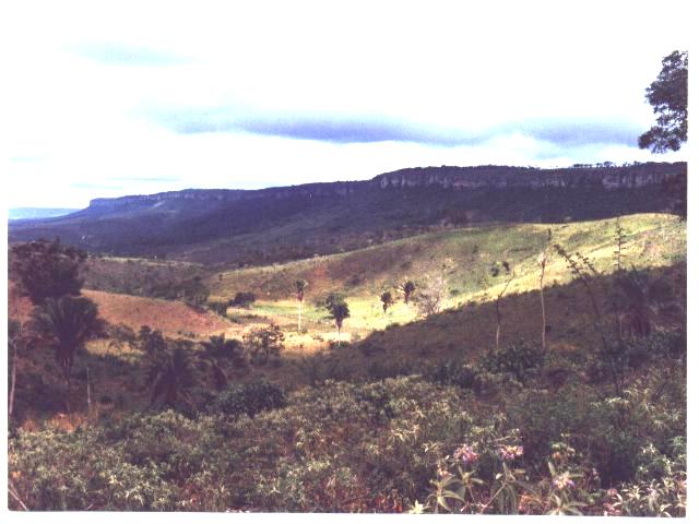
Foto 1
- Escarpa do Tombador vista da serra das Palmeiras, visando sul.
Photo 1 - Tombador escarpment seen from Palmeiras range, looking south
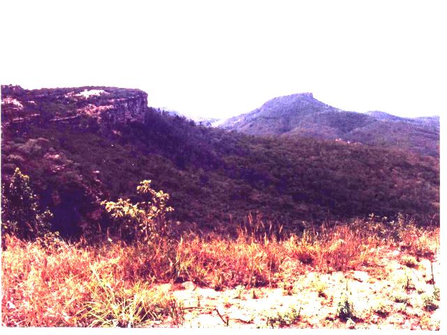
Foto 2 -
Morro do Cruzeiro visto da serra do Tombador, visando norte.
Photo 2 - Cruzeiro hill seen from Tombador range, looking north.
ABSTRACT
The Tombador range that is part of the Chapada Diamantina eastern
escarpment, is formed by clastic sedimentary rocks of the Tombador Formation that is older
than one billion years. These rocks are composed by conglomerates and sandstones of
eolian, fluvial and deltaic facies, with predominance of the first one. The Tombador
Formation was described in the first decade of the present century is deposited on a
basement composed by TTG (tonalite-trondjhemite-granodiorite) orthogneisses, acid
meta-volcanic rocks, granodiorites and porphyroclastic monzonites. In the Tombador range
itself, this unconformity (non-conformity) between this basement and the sedimentary rocks
of the Tombador Formation may be observed. They consist of sandstones with bimodal
granulometry and large scale cross bedding. In the middle part of the formation, the cross
bedding co-sets that have levels with rain pits are bounded by surfaces with thin beds of
horizontally bedded sandstones. These surfaces are interpreted as result of discontinuous
elevations of the water table. The lithologies and structures of the Tombador Formation
characterize it as a perfectly preserved paleo-desert. Owing to an elevation of its level,
the sea transgressed on the Tombador Formation, depositing upon it argillites and
siltstones of the Caboclo Formation in a tidal flat environment. The bimodal sandstones of
the Tombador Formation are exploited as slabs for floor revestment.
Key words: Precambrian, Chapada Diamantina,
Tombador range, desertic environment
INTRODUCTION
The Tombador range is an escarpment
longer than 75km, where crops out the Mesoproterozoic Tombador Formation, in the
center of Bahia State. The escarpment, that trends NNE-SSW is part of the
eastern edge of the region named Chapada Diamantina (photo 1). The Tombador
range, in its north-south development, takes several local names as Tombador do
Araújo, Palmeiras range and Gameleira range. Its main sector is between the
BR-324 and BA-052 roads, that cross the Tombador and Gameleira ranges. Towards
north and south, its altitudes decrease, and to the north it is covered by
Neoproterozoic sedimentary rocks. The stratigraphic, sedimentologic, tectonic
and geomorphologic features of the Tombador range have been object of research
since the beginning of this century. In this range may be advantageously studied
sedimentation processes older than one billion of years, as well as the tectonic
and geomorphologic evolution of the rocks along the geological time.
LOCATION
The Tombador range diagonally crosses the 400 45' meridian and
is bounded north and south by the parallels 110 00' and 120 00'
(figure 1). This situation makes the Tombador escarpment to be almost paralel to the
Jacobina range, from which is separated by a wide valley.
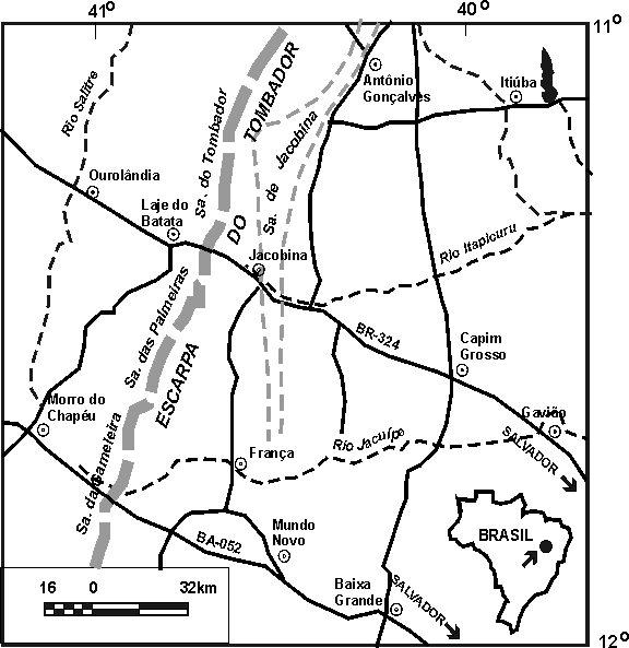
Figura 1 - Mapa de
localização da serra do Tombador. O encarte mostra a situação da região no Brasil.
Figure 1 - Location of the Tombador range. Inset shows the situation
of the region in Brazil.
HISTORICAL DATA
The travel notes of Mr J. A . Allen, ornitologist of the Thayer
Expedition, refer to his traverse from the hamlet of Chique-Chique on the São Francisco
river, to the town of Bahia (Salvador) approximately in the year 1868. In these notes, he
comments about his crossing of the Jacobina Plateau, the highest region where is presently
located the hamlet of Laje do Batata (figure 1). From this plateau, one descends eastwards
"through a narrow and precipitous canyon".
In the first decade of this century, the region was studied by
J.C. Branner, a british geologist of the Geological and Mineralogical Survey of Brazil,
who traversed along the several roads that cross the range. He described the basement that
separate it from the Jacobina range as composed by " granites, gneisses, schists
and old eruptives...The hills made of these rocks are mostly low and rounded ".
The rocks of the range that he named Tombador Series, were described as " sandstones
and quartzites and the series is unbroken by intercalated shales...about a hundred meters
thick... the rocks are rather soft and much joited, while in color are
pinkish, yellowish, reddish and grayish...Along the face of the bluffs as seen from the
old trail a couple of kilometers north of the present trail, the false beds are often
three or four meters high...Going westward or northwestward down the slope of the range,
one passes from the Tombador sandstones to a series whitish flinty beds that the writer
has called the Jacuipe flints... They are well developed in that part of the range locally
known as the Serra da Gameleira...Next above the Jacuipe flints and resting conformably
upon them is a series of shales that were given the field name of Caboclo shales..."
. Branner 's descriptions are perfect: taking into account the latter studies and the
evolution of the knowledge, that determined the basement composition as TTG orthogneisses,
acid metavolcanic rocks, granodiorites and porphyroclastic monzonites (Sampaio et al.,
1995), and the false stratification as large scale cross bedding, there is nothing to add.
Branner's paper is illustrated with his drawings, one of them reproduced in figure 2.
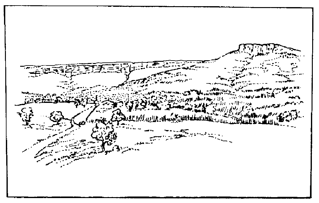
Figura 2
- Serra do Tombador, vista da Fazenda Santa Cruz (esboço de J.C. Branner). À direita,
está o morro do Cruzeiro, onde a Formação Tombador aflora separada da escarpa principal
(foto 2).
Figure 2 - Tombador range seen from Santa Cruz ranch (sketch by J.C.
Branner). At the right hand side, is the Cruzeiro hill, where the Tombador Formation crops
out separated from the main escarpment (photo 2).
The Projeto Bahia
(Pedreira et al., 1975), restablished the original names of Tombador and Caboclo
formations. In the Tombador range, where the "Jacuípe flints" do not crop out,
the contact between the Tombador and Caboclo formations was described as transitional.
In 1987 the National Department of Mineral Production (DNPM) jointly with
the Mineral Resources Exploration Company (CPRM) opened in the town of Morro do Chapéu
(figure 1), the Integrated Center of Geologic Studies (CIEG), in order to train
technicians of the two agencies, execute and give support to studies regarding the
sedimentary rocks that crop out in the region. One of these studies was the survey along
the roads that cross the escarpment of the range (Gameleira and Palmeiras ranges, Angelim
creek, Gogó da Gata and Tombador range), to make the faciologic analysis of the Tombador
Formation. The panel-diagram of the figure 3 displays and correlates these sections. In
the panel is outstanding the predominance of eolian facies in the Tombador Formation
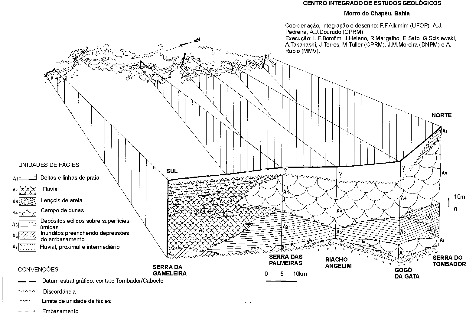
Figura 3
- Correlação entre as litofácies da Formação Tombador analisadas nos perfis das
serras da Gameleira e das Palmeiras, riacho Angelim, Gogó da Gata e serra do Tombador.
Figure 3 - Correlation among the profiles of Tombador Formation
analysed in the profiles of Gameleira and Palmeiras ranges, Angelim creek, Gogó da Gata
and Tombador range.
Finally, recent observations
show that under the view point of sequence stratigraphy, Tombador Formation is a
lowstanding systems tract, and its contact with the Caboclo Formation is a transgressive
surface; the latter represents a highstanding systems tract.
DESCRIPTION OF THE SITESince the town of Jacobina, looking west, one can see far away the
Tombador range. Following the BR-324 road towards Lage do Batata, about 18km west of
Jacobina it is possible to observe the unconformity between the basement and the Tombador
Formation. In the photo 3, this unconformity is below the vertically fractured beds that
continue to the right side of the tree. The lighter colored hill is formed by weathered
rocks of the basement.
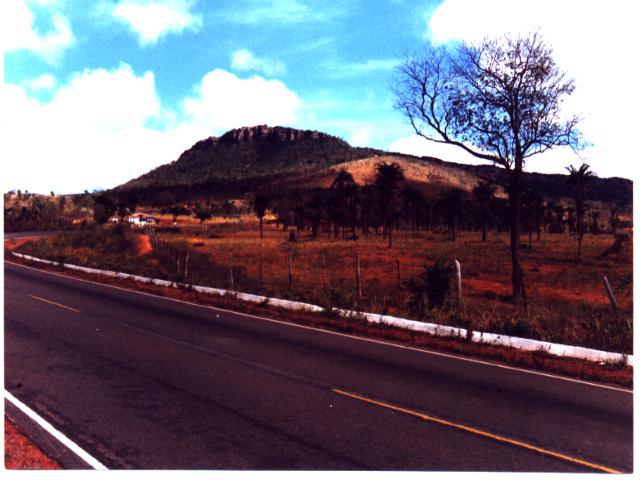
Foto 3
- Discordância (não-conformidade) entre os arenitos da Formação Tombador e o
embasamento cristalino. Rodovia BR-324, cerca de 18km a oeste de Jacobina.
Photo 3 - Unconformity (non-conformity) between the sandstones of the
Tombador Formation and the crystaline basement. BR-324 road, about 18km west of Jacobina.
This unconformity can be
observed in detail about two kilometers farther west (photo 4). In this place it is marked
by a thin bed of fluvial conglomerates, overlain by whitish eolian sandstones. The
conglomerate has green quatzite pebbles whose source area is the Jacobina range. Also it
may be observed that the unconformity is not a planar surface: the sandstones of the
Tombador Formation infill basement depressions.
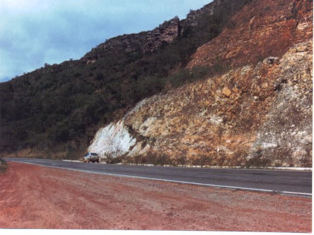
Foto 4
- Detalhe da discordância entre a Formação Tombador e o embasamento cristalino (acima
do automóvel), 20km oeste da cidade de Jacobina.
Photo 4 - Detail of the unconformity between the Tombador Formation
and the crystaline basement (above the car), 20km west of the town of Jacobina.
The sandstones above the
unconformity have bimodal grain size, and large scale cross bedding. The bimodality of the
sandstone, that is, the fact that it is formed by lines of coarser and finer grains, owes
to the variations of wind velocity, when the grains were transported: stronger winds
transported the coarser grains; the weaker winds transported the finer ones.There are four levels of these sandstones, separated by sub-horizontal
surfaces. The lower one ends against the road, whereas the upper one is in the right hand
corner of the photo 5. The beds that separate these levels are horizontally bedded and are
interpreted as bounding surfaces, formed by the elevation of the water table (Medeiros et
al., 1971). The lowest level would be a dune field; the rise of the water table fixed
the dunes, so that the wind removed the loose sand above it. Upon this flat surface a new
dune field formed and a new rise of the water table fixed it. How many times this process
occurred is impossible to say: in the Tombador range are preserved only these four levels;
others, if present, were eroded.
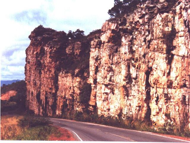
Foto 5 -
Superfícies de truncamento, formadas pela elevação do nível do lençol de água
subterrânea, que separam conjuntos de estratificação cruzada de grande porte.
Photo 5 - Bounding surfaces formed by the elevation of the water
table, separating large scale cross bedding cosets.
In the western end of the upper level,
large scale cross beds can be observed besides the road. In the photo 6, the upper beds
have shallow dips to the left; the lower ones, where the hammer is, have steeper dips to
the right side.
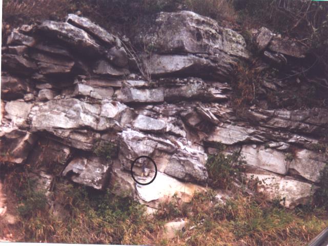
Foto 6 -
Estratificação cruzada de grande porte em arenitos eólicos da Formação Tombador. O
círculo assinala um martelo como escala.
Photo 6 - Large scale cross bedding in eolian sandstones of the
Tombador Formation. Hammer within the circle as scale.
In the lower part of the outcrop shown
in the photo 6, there are some levels with a great number of tiny circular holes (photo
7). These holes are interpreted as rain pits and, according to McKee (1979), are
diagnostic features of dune deposits.
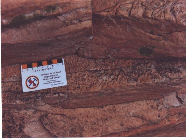
Foto 7 -
Pingos de chuva preservados na parte inferior do afloramento mostrado na foto 6.
Photo 7 - Rain pits preserved in the lower part of the outcrop shown
in photo 6.
In the top of Tombador range, the
bedding of the sandstones is horizontal, owing to the marine invasion that deposited the
Caboclo Formation. The tidal currents reworked the unconsolidated sands , changing the
cross beds into horizontal ones. The Caboclo Formation consists of an alternance of
argillites and siltstones (photo 8). In these rocks were found contractional structures,
that allow to interpret them as tidal flat deposits, corresponding to an elevation of the
level of the sea that transgressed upon the Tombador Formation.
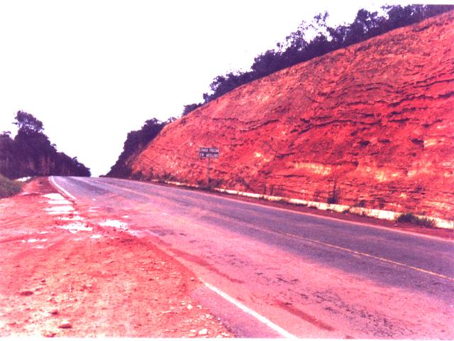
Foto 8
- Argilitos e siltitos interacamados da Formação Caboclo no povoado de Meio, topo da
serra do Tombador.
Photo 8 - Interbedded argillites and siltstones of the Caboclo
Formation in the hamlet Meio, top of Tombador range.
The Tombador range is not just a succession of outcrops along a
road. It represents a perfectly preserved paleo-desert older than a billion years, where
the processes that lead to its formation can be examined: the filling of the basement
depressions, the wind direction and the variations of its speed, the elevations of the
water table, the occasional rains, and the final marine invasion.
PROTECTIVE ACTIONS
The bimodal granulometry of the Tombador Formation sandstones,
eases the mining of slabs used as dimension stones. This activity is exerted intensively
in the Tombador range as shows photo 9, without intervention of the governamental
authorities.
Foto 9
- Extração de lajes de arenito na Formação Tombador, para produção do "Arenito
Jacobina".
Photo 9 - Mining of sandstone slabs in Tombador Formation for the
production of the "Jacobina Sandstone".
REFERENCES
Branner, J.C.,1910. The Tombador Escarpment in the State of
Bahia, Brazil. American Journal of Science, 30: 335-343.
Mc Kee, E.D. 1979. Ancient Sandstones Considered to be Eolian.
In: Mc Kee, E.D. (ed.) A Study of Global Sand Seas. Washington, D.C., U.S.
Government Printing Office, Geological Survey Professional Paper 1052, p. 187-238.
Medeiros, R.A .; Schaller, H.; Friedman, G.M.,. 1971. Fácies
Sedimentares; Análise e Critérios para o Reconhecimento de Ambientes Deposicionais.
Rio de Janeiro, Petrobrás, CENPES, Divisão de Documentação Técnica e Patentes, 123 p.
Pedreira, A .J.; Arcanjo, J.B.; Pedrosa, C.J.; Oliveira, J.E.;
Silva, B.C.E. 1975. Projeto Bahia; Relatório Final; Geologia da Chapada Diamantina.
Salvador, DNPM/CPRM, 2v. (Relatório inédito).
Sampaio, A .R.; Santos, R.A .; Rocha, A .J.D. (orgs.), 1995. Jacobina;
Folha SC.24-Y-C; Escala 1:250.000. Brasília, CPRM. (Mapa Geológico).