
SIGEP
Geological and Paleontological
Sites of Brazil - 025
SETE CIDADES
NATIONAL PARK
Piauí State
Date: 01/07/1999
JORGE DELLA FAVERA
favera@uerj.br
Universidade do Estado do Rio de Janeiro
Faculdade de Geologia
Rua São Francisco Xavier, 524, 4º Andar, Ala “A”
20559-900 – Rio de Janeiro – Rio de Janeiro
© Della Fávera,J.C. 1999. Parque Nacional Sete Cidades, Piauí. In: Schobbenhaus,C.; Campos,D.A.; Queiroz,E.T.; Winge,M.; Berbert-Born,M. (Edit.) Sítios Geológicos e Paleontológicos do Brasil. Published
1/7/1999 on Internet at the address http://www.unb.br/ig/sigep/sitio025/sitio025english.htm [Actually
https://sigep.eco.br/sitio025/sitio025english.htm]
[SEE
PRINTED CHAPTER IN PORTUGUESE]
(The above bibliographic reference of author copy rights is required for any use of this article in any media, being forbidden the use for any commercial purpose)
|
ABSTRACT
The Sete Cidades National Park is a magnificent natural
monument made of outcrops of Devonian strata of the Parnaiba sedimentary basin. This park
is located in the northeastern part of the state of Piauí, almost 200 km far from
Teresina, the state capital. It is reached through the BR-216 highway.
This park is named after seven different rock outcrops,
each one considered a “city”. The ruinform topography mimics shapes from
persons, animals and things, which take several pertinent names, as Dom Pedro I’s
head (former Brazilian emperor), indian’s head, camel, tortoise, library, etc.
Apart from the geological
attractions the Sete Cidades Park is internationally known for its rupestrian
inscriptions. This inscriptions were dated through the C14 radiometric method
presumably from 6000 years ago and are interpreted to show
different situations, like hunting, as well as
religious concepts.
Sete Cidades is in the proximal portion of a delta lobe,
so it presents features of fluvial and deltaic sedimentation. Medium-sand is the dominant
grain-size in the area but gravel conglomerate and silt are also found. Several different
sedimentary structures can be recognized in the rock outcrops. Trough cross-bedding,
sigmoidal bedding, climbing ripples and plane-parallel
stratification, most of them disturbed by water escape structures are the main sedimentary
features. The tower-like features are separated by steep vertical walls which clearly
depict rain-water and wind carving controlled by jointing planes.
The park is presently run by IBAMA (Instituto Brasileiro
de Meio-ambiente e Recursos Naturais Renováveis) which takes care of the conservation
policy, signalization and guiding throughout the park. An hotel with lecturing facilities
is open to tourists the year round.
INTRODUCTION
The
Sete Cidades National Park, located in the Piauí State (Figure 1), Brazil, is an impressive
collection of natural monuments, made of outcrops of Late Devonian rocks (Fammenian). Rock
outcrops can be assembled together into seven
groups, forming seven “cities”. The cities are in the southern end of the
so-called Serra Negra (Figure 2).
The climate is pleasant with a year average of 26o
C, and the seasonal rainy time in the late Spring going to late Fall favors the
preservation of sedimentary features. The scarcity of vegetation (cerrado) helps the depiction of internal structures and vertical
successions that allows the interpretation of fluvial
and deltaic environments. Besides, a ruinform topography, carved by wind and pluvial water
in sandstones, generates tower-like or domal features in
narrow gorges which suggests shapes of man, animals and objects. These forms have
been stimulating the imagination of several
researchers: Ludwig Schwennhagen, an Austrian historian, described it as an ancient
Phoenician city built some 3000 years ago; Erich von Däniken, a Swiss journalist, linked
it to other monuments that suggested him the
visit of extraterrestrial civilizations in the past.
In
the steep walls of the rock outcrops, covered
by a siliceous patina, iron-oxide inscriptions made by primeval men can be seen. The age
of this inscriptions is under dispute. Some researchers point out an age of 6000 years,
based on C14 dating, whereas
Fortes (1996) interpreted them as post-Colombian in age, done probably in the nineteen
century. The inscriptions are interpreted as
to figure out hunting procedures and religious themes.
Several
features found in Sete Cidades are common to the Vila Velha National Park, near Ponta
Grossa, Paraná. Vila Velha is mostly fluidized by water escape phenomena. Convolute
bedding is the most common structure. Liesegang rings and alveolar erosion are also
common. Both occurrences seems to be the result of a delta construction under periglacial
conditions.
In
this park, typical representatives of the local fauna and flora can be found. It can be
named as a “cerrado”, with spots of open fields and ciliary forests. The fauna
seems to be richer than the typical “cerrado” one, as a function of the presence
of the “caatinga” and the latifoliate forest animals. For example, the
veado-mateiro (Mazama americana), a kind of deer
of the latifoliate forest, the iguana (Iguana
iguana), also an amazonian species, and the mocó (Kerodon rupestris),
a rodent typical from the caatinga, are also found in Sete Cidades.
Both
geological and historical features enables the Sete Cidades National Park as a very
interesting site for scientific research.
In
order to protect fauna and to recover degraded areas, 5600 ha of the park area are kept
provisionally closed for visitors. Medeiros (1998) proposes an increase in the park area
of 5100 ha
in the eastern side in order to include other geological monuments and to get a
better integration of flora and fauna.
For
more information about the geology and other features of the park, the readers are
addressed to the book by Fortes (1996), which is plenty of illustrations and contains very
good geological interpretations.
LOCATION
The
Sete Cidades National Park is located in the northeastern part of the Piauí State,
belonging to the Piracuruca and Piripiri counties among the coordinates 04o05’ to 04o15’
S and 41o30’ to 41o45’W. The area is 6221 ha.
It
is reached by the BR-343,
Teresina-Parnaíba, and the BR-222, an
extension of the former highway to Fortaleza (Figure 1). Distance from Teresina, the
Piaui’s capital, is 217 km and from Fortaleza, Ceará’s capital, is 422 km. The easiest way to reach Sete Cidades
Park is by plane to Teresina or Fortaleza and
after by car following the above mentioned highways. From Teresina, leaving the BR-343 one
should enter the BR-222, going 12 km and then reaching the southern park gate by a
secondary road, 12 km long. From Fortaleza, just keep in the BR-222, then reach the south
park gate by the same secondary road. The
highway signalization is good and the
asphalt pavement was fair at the time of writing this chapter but it can attain a bad condition after the heavy rain period in
Summer.
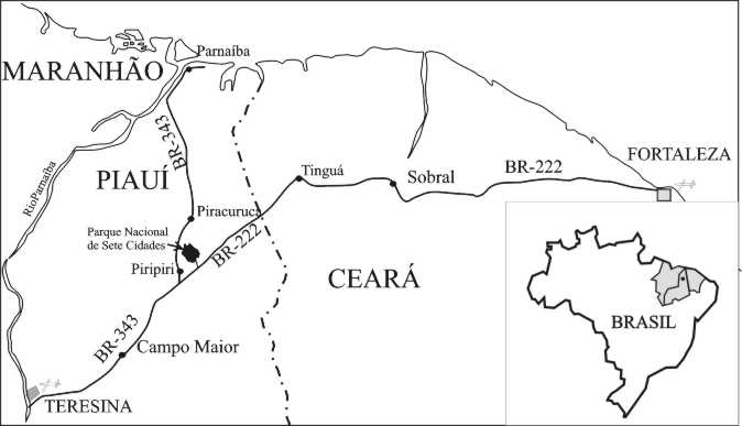
Figure 1 - Location map of the Sete Cidades
National Park and the possible ways to reach it.
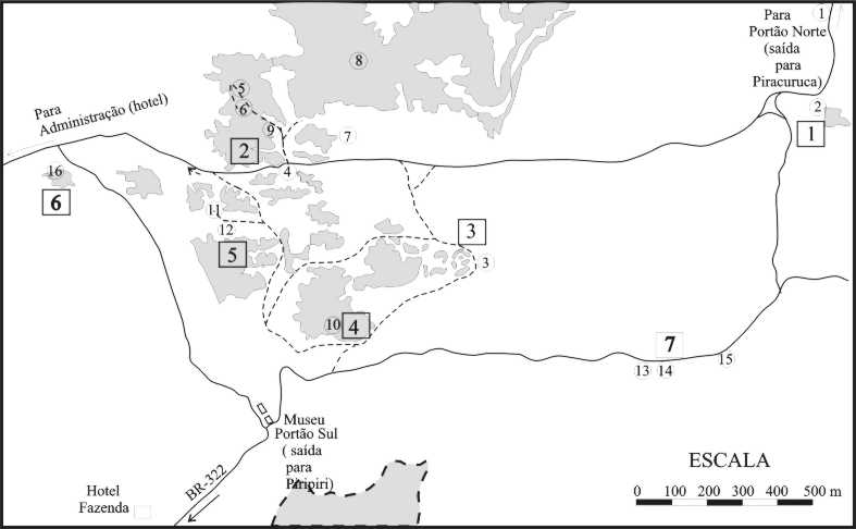
Figure 2 - Location of “cities” in the park (numbers
in squares). In gray, rock outcrops. In circles: 1) Warm fountain; 2) Cannons; 3)
Suspended garden; 4) Arch of Triumph; 5) Library; 6) Belvedere; 7) Castle; 8) Lizards;
9)Inscriptions; 1)) Archette; 11) Inscriptions; 12) Indian’s cave; 13) Witch
doctor’s cave; 14) Little church; 15) Gate; 16) Inscriptions (modified from Fortes,
1996).
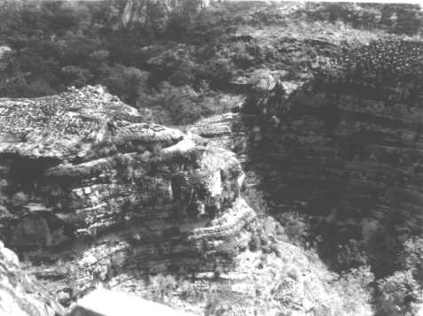
GEOLOGICAL SETTING
Geologically, it is
located in the Parnaíba Sedimentary Basin, one of the largest Brazilian intracratonic
basins, with 600,000 km2 in area. This basin encloses a sedimentary pile
belonging mainly to the Paleozoic, which starts in the Silurian.
The Devonian rocks
include the Pimenteira, Itaim and Cabeças formations.
According to the sand isolith map of the Cabeças Formation (Figure
3) (Della
Fávera, 1990) , this park is situated in
the southern flank of a huge sandy sedimentary wedge coming from northeast, in the top of
a section dated as Late Devonian (Famennian). According to Caputo (1985), there was a
clear glacial event, recognized from diamictites and striated pavements, in this section
and in the overlying shaly Longá Formation.
Therefore, the park area is presumably
covered by a sort of periglacial sediments.
Vertical
successions of facies in the area shows fluvial to deltaic sediments. Most successions are
fining upwards, showing basal truncations, as the “library” (second city,
figure 5). In this site, the basal portions are made up of coarse to medium sandstone with trough
cross-bedding. According to Fortes (1996), the channels run in a southeast to northwest direction, which is the dominant direction of
transportation in the entire basin. In the “canhões” area (first city), pebble conglomerate in festoons can be seen in
the base of a fining upwards succession. Other structures include sigmoidal bedding and
climbing ripples as wells as parallel laminated silt.
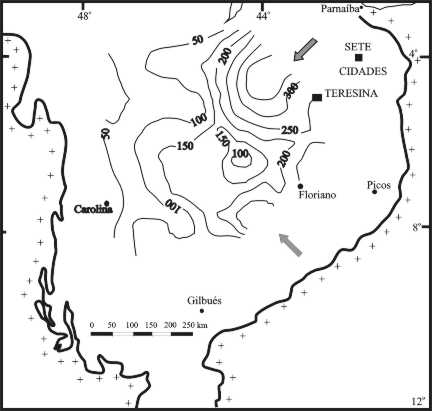
Figure 3 - Sand isolith map of the Cabeças Formation built after
data from wells drilled for oil by Petrobras in the Parnaiba basin. Please note the
position of the Sete Cidades National Park in the southern flank of a deltaic lobe in the
northeastern portion of the basin (Della Fávera, 1990).
A dominant feature
is the water-escape structure. This kind of deformation affects mainly the sigmoidal
lobes. Probably water escape occurred as a function of the large volumes of sediments
deposited in short times, which is expected in periglacial areas, with catastrophic
flooding.
HISTORY
The first
historical reference to the Sete Cidades site is the communication to the Brazilian
Historical and Geographic Institute made by
the Counselor Tristão de Alencar Araripe, called “Petrified Cities and Rock
Inscriptions in Brazil”, in December
ninth, 1886. The first description of Sete Cidades was made by the Piracuruca’s
County Counsel in a communication to same Institute in 1897.
In 1928, the
Austrian Ludwig Schwennhagen visited Sete Cidades and described them as ruins of a
Phoenician city, founded 3 thousand years ago. Erich von Däniken, in his famous book
“Were the gods astronauts?”, described Sete Cidades as a clue to the presence of extraterrestrial intelligence in Earth, in the
60’s. Afterwards, in 1974, the French
Jacques de Mahieu assumed that the vikings had been settled in Sete Cidades.
The Piauí
researcher Reinaldo Coutinho (Coutinho, 1997) analyses the history of the discovery of
Sete Cidades, as well as comments the several theories about the meaning of the cities of
stone and its inscriptions.
The park was
officially created by the Federal Decree number 50.744 in June eight 1961.
DESCRIPTION
OF THE “CITIES”
Sete Cidades Park
is divided into seven different rock outcrop assemblages, called
“cidades”(“cities”) (Figure
2).
First City
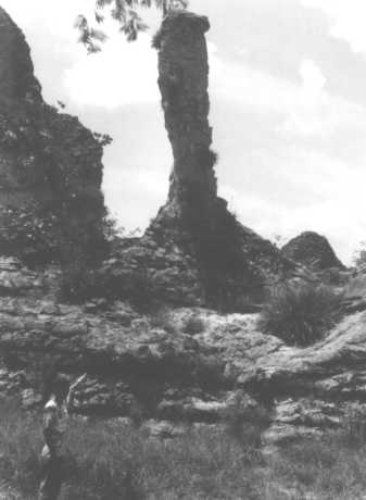
The First City is
characterized by diagenetic features known as
“canhões”(“cannons”), long tubes made of ferrified sandstones
(Figure 7). This diagenetic product is also known as
“rolls” or Liesegang rings and consist of a chromatographic-like migration of
iron hidroxides into a permeable and isotropic medium,
normally fluidized sandstones.
Notably, the
cannons are inside fluvial deposits, characterized by a basal truncation and conglomerates
with trough cross-bedding in a fining upwards vertical succession. Erosion accentuates
these forms, which detach them from the enclosing rocks as cylindrical bodies (foto 1).
Second City
This
city is characterized by very interesting features. The first feature, revealing alveolar erosion, is the so-called “Arch of Triumph”.
Alveolar erosion is produced by caving of homogenous sandstone, giving rise to vulva-like
features and lately to natural archs.
Walking
from the “Arch of Triumph”, inscriptions
painted in vivid red colors, painted by a mixture of iron oxide, vegetable oil or animal
blood, can be seem,. They suggest impressions
of hands and were painted probably by indians from the tribe Tabajara. According to C14
radiometric dating, they would be 6000 years
old.
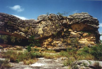
The
“library” (Figure 5) is another interesting feature. It is made up of an erosion
surface at the base of medium sandstone channel deposit with trough cross-bedding, which
truncates fine to medium sandstone and
siltstone with plane-parallel bedding. This parallel bedding reminds books piled up in a
library. In this site, well-sorted sandstone suggests an eolian reworking source to this
delta-like sandstones. As seen from the belvedere (Figure 8), the plane-parallel bedding is the distal portion
of climbing ripples sets which in turn are the frontal extension of sigmoidal lobes (Della
Fávera, 1984).
Third City
In
this city, several ruinform features can be seem, as the God’s Finger (Figure
9), the head of Dom Pedro I, former Brazilian emperor, and the Indian’s head. The Head of Dom Pedro
I (Figure
10) is again the erosional contact of a fluvial-like feature, with medium sand
over finer sediments.
Fourth City
The
most characteristics features of this city are the “Archette” (Figure
11), where deformed sigmoidal bedding can be seen, and
the Brazil’s map. Both are the result of alveolar erosion giving rise to caves and
arching. Convolute bedding and strongly distorted bedding are very common in this site.
Fifth City
This
city is famous by its inscriptions. A drawing interpreted as defining the ritual of
hunting and the final destination of man has been used as an icon representing the Sete
Cidades National Park and the neighboring
counties. The current interpretation of this inscription is: “the indian follows the
trail, chases the animal, kill it and offer it to the god Sun” (Figure
4).
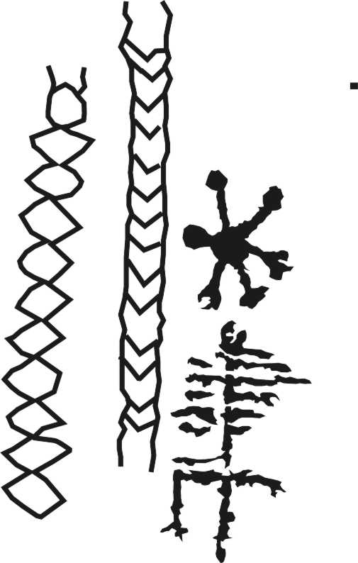
Figure
4 - Inscription in the Fifth City:the
indian follows the trail, chases the animal, kill it and offer it to the god sun
Figure
5 - Library. Second City.
Truncated basal contact between a fluvial deposited over finer sediments with
plane-parallel stratification.
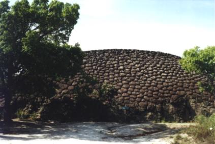
Figure
6 - Tortoise shell.Sixth City. This form is famous by its
polygonal features, covered by lichens.
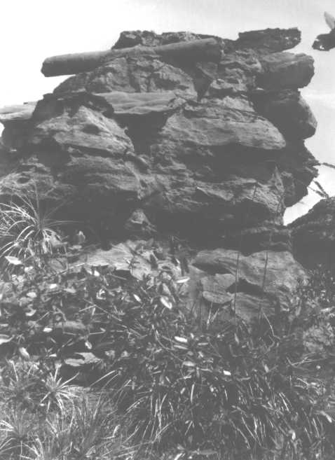
Figure
7 - Cannon. First City. This feature is a product of
diagenetic transformations by iron oxide. It is inside fluvial deposits with conglomeratic
sandstone and trough cross-bedding.
Figure
8 - Climbing ripples in plane-parallel sets, which pass
laterally to sigmoidal lobes. Second City
Figure
9 - God’s Finger. Third City.
Figure
10 - Dom Pedro I’head.. The head is supported by the
neck throughout an erosion surface. Third City.
Figure
11 - This cave is a product of alveolar erosion. Fourth
City.
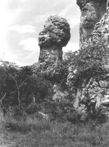
Sixth City
The tortoise (photo 2) and the elephant are the most
known features of this city. Both are forms covered by mostly pentagonal polygons which
normally puzzles the geologist both in origin as in the formation process.
Some geologists believe that these polygons are
an heritage of former glacial conditions in time of deposition of sand. Fortes (1996)
assumes them as contraction cracks, where the running water from rain carved ladder-like
polygons. As a matter of fact, polygons are a very common feature in Sete Cidades as well
in another ruinform site, the Buriti Alps, near Picos, in the central-eastern part of the
Parnaiba Basin.
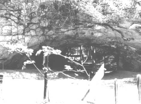
Seventh City
In this city, alveolar erosion and polygons
features are the main atractions. The Indian’s cave is a good example of alveolar
erosion, covered by polygons.
CONSERVATION POLICY
The main objectives for controlling the area are
(Medeiros, 1998):
- to keep an area dominated by the cerrado
vegetation, with caatinga and latifoliate forest elements, its ecological diversity,
potentialities and genetic resources;
- to keep the representative biotic community that
occurred originally in this area;
- to keep geological monuments and the scenic
beauties;
- to keep the hydrological production;
- to keep rupestrian paintings and other objects of
the historic-cultural heritage;
- to promote education in order to get public
respect to environment;
- to make possible and to promote scientific
research and general studies inherent to the park objectives; and
- to promote leisure within the general objectives
of the park.
As
all that exists in the park belongs to the community,
visitors are not allowed to dispose any material in trails, roads, belvederes and picnic places; to polute and spoil soils and creeks; to mutilate
plants; to set fires or lit candles for religious rites out from the proper places for it;
to chase or hunt the park animals, to make
excessive noise, as shouting or to keep high volume stereos and radios; and to pull or to break signalization plates.
AKNOWLEDGEMENTS
The
author is indebted to the Geol. Hernani F. A. Chaves, Faculdade de Geologia, UERJ, who
accompanied him in a photographic field trip to the park, in January, 1999, which gave
rise to very interesting discussions about the geology and the inscriptions.
My
thanks are extensive to Dra. Eugênia Medeiros, IBAMA, Teresina, who kindly provided official
papers and IBAMA regulations about the Sete Cidades National Park.
I
am also indebted to Marcos Aurélio Furtado Coelho, attached to the IBAMA, Sete Cidades, who diligently guide us through the park in
January 1999.
Geol.
Marco André Malmann Medeiros helped in preparing illustrations for this chapter; Enga.
Romana Begossi corrected the manuscript.
BIBLIOGRAPHIC REFERENCES
Caputo,M.V. 1985. Late Evonian Glaciation in South America. Palaeogeography, Palaeoclimatology, Palaeoecology,
51:291-297, 1985.
Coutinho,R. 1997. Enigmas de Sete Cidades.
Ideal, Piripiri, 78 p.
Della Fávera, J.C. 1984. Eventos de Sedimentação Episódica nas bacias brasileiras.
Uma contribuição para atestar o caráter pontuado do registro sedimentar.
In: XXXIII Congresso Brasileiro de Geologia,33,Rio de Janeiro,1984, SBG. Anais:489-498,
.
Della Fávera,J.C. 1990. Tempestitos da Bacia do Parnaíba. Um ensaio
holístico. UFRGS, Porto Alegre. Tese de Doutoramento, 243 p..
Fortes,F. 1996. Geologia de Sete Cidades. Fundação Cultural Monsenhor
Chaves, Teresina, 142 p.
IBAMA. 1979. Nac– Plano de Manejo – Parque Nacional de Sete Cidades.
Brasília, 61 p.
Medeiros,E.S. 1998. Projeto de sinalização do Parque Nacional de Sete
Cidades. IBAMA, Teresina, 43p.
Schwennhagen,L. 1928. História Antiga do Brasil – de 1100 AC a 1500
DC. – Teresina , Imprensa Oficial.