 SIGEP SIGEP
Geological and Paleontological
Sites of Brazil - 018
IRAQUARA CAVES
(Iraquara, Seabra e Palmeiras –
Bahia state)
Date: 30/09/99
Fernando Verassani Laureano
laureano@gcsnet.com.br
Francisco William da Cruz Jr.
cbill@usp.br
Instituto de
Geocięncias-Universidade de Săo Paulo
Rua do Lago 562, Săo Paulo-SP, Brasil
© Laureano,F.V.; Cruz Jr,F.W. 1999. Iraquara caves (Iraquara, Seabra e Palmeiras, Bahia state,
Brazil). In: Schobbenhaus,C.; Campos,D.A.; Queiroz,E.T.; Winge,M.; Berbert-Born,M. (Edit.) Sítios Geológicos e Paleontológicos do Brasil.
Published
30/9/99 on Internet at the address http://www.unb.br/ig/sigep/sitio018/sitio018english.htm
[actually
https://sigep.eco.br/sitio018/sitio018english.htm]
[SEE
PRINTED CHAPTER INC P CAPÍTULO IMPRESSO]
(The above bibliographic reference of author copy rights is required for any use of this article in any media, being forbidden the use for any commercial purpose) |
Abstract
The occurrence of an expressive density of caves,
some of them comprised by great systems, become the area around Iraquara city, central
Bahia, one of the most important speleologic sites of Brazil. Those cavities were sculpted
in neoproterozoic carbonatic rocks of the Salitre Formation (Una Group), in the
southernmost part of Irecę Basin. The region has a cultural and scientific importance and
exhibit a very representative karst landscape in Brazil. Geo-espeleological and
morphological studies from local caves point out a multiphasic evolution history,
involving opening, enlargement, infilling, sediment erosion and conduit destruction. Such
caves has been used mainly for water supplies and, nowadays, represents a special
attractive to ecotourism.
Introduction
The underground structure in the Iraquara region
sustains the grandness and beauty of the Chapada Diamantina, one of the finest scenic
regions in Brazil. The network of underground galleries forms one of the country's most
significant speleological sites in which more than a hundred caves are currently known.
The region possibly has the highest frequency of caves per unit area in the country (Auler
& Farrant, 1996). Forms are varied, and the lengths of many caves are kilometric.
Apart from their scenic beauty the Iraquara caves
conserve geological, geomorphological, paleontological, archeological and biological
features which give them strong multidisciplinary interest. Their kilometres of
large-scale passages are the record of underground erosive processes, which are a
reflection of the action of geomorphological agents in the formation of the present
countryside. The sedimentary record in the passages reveals the evolution of environmental
conditions in the region over the last few million years of Earth history. The sediments
also contain the fossil register of the Pleistocene Megafauna, which includes giant sloths
(Scelidodon Cuvieri) and sabre-toothed tigers (Smilodon populator) which inhabited the
region before their extinction. Flooded passages are at present the habitat of small,
blind albino catfish, of great biological importance since they belong to a new species
presently known only from the Lapa Doce (Liana Mendes, 1999, verbal communication). Some
caverns, such as the Lapa do Sol and the Abrigo Santa Marta, have paintings at their
entrance, providing a register at present poorly known of the prehistoric inhabitants of
the region.
These natural cavities have an importance over and
above their scientific interest, since the karstic aquifer are one of the main natural
resources in the region where the surface river beds are usually dry and the underground
sources provide water for agricultural use and human consumption. The growth of ecotourism
in the Chapada Diamantina has drawn attention to the possibility of exploiting the tourist
potential of the various types of underground scenery, and four caverns - Lapa Doce, Gruta
da Torrinha, Buraco do Căo and Gruta da Pratinha - have already been included in tourist
routes in the area.
The plaque at the crossroads at the entrance to
the city advertises "Iraquara - the city of the caves". Welcome to another
Brazilian natural monument.
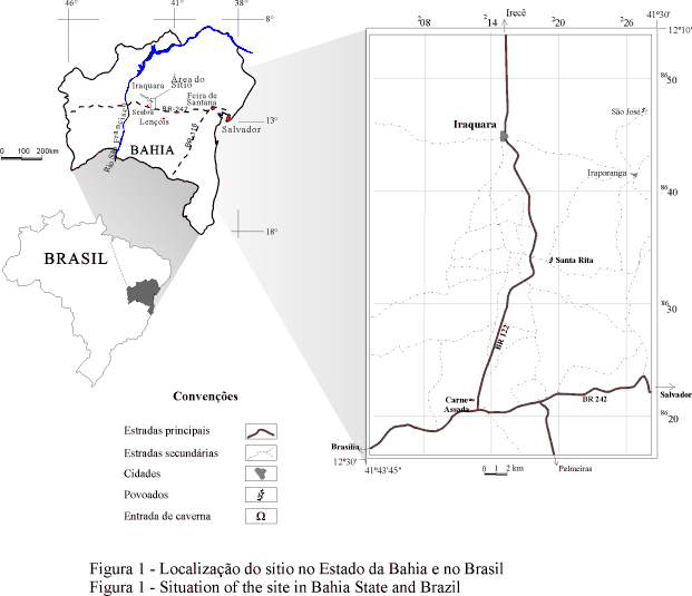
Location
The site is in the north-central part of the
Chapada Diamantina in the centre of Bahia State (Figure 1). The main acess to Iraquara,
which is 450 km from Salvador, is by the BR-242 Salvador - Brasília highway to Carne
Assada, from where the BR-122 "Estrada do Feijăo (Bean Road)" leads to
Iraquara. Seabra, 40 km to the Southwest, and Lençois, 70 km to the Southeast, are the
other main cities in the region.
Historical background
Before the eighties, the local karst features were
only mentioned in regional studies, such as Tricard & Silva (1968), which lacked
descriptions of the caves in the area. In the eighties, Guerra (1986) gave a preliminary
geological and hydrological description of the karst countryside as closed depressions
which occur along the carbonate rock belt between Iraquara and Irecę.
Speleological surveys of the region are more
recent, starting in 1986 with the Franco-Brazilian Expedition led by the Ceará
Speleological Group (GEECE). The main result of this expedition was the surprising
discovery of the Lapa Doce cave which at that time was the largest in Brazil. Since then,
other group organized by the French undertook surveys of the other large caves in the
region, such as the Lapa da Torrinha, the Gruta Azul and the Căo-Talhăo system. Panchout
& Panchout (1995) have presented a synthesis of the activities undertaken.
In 1988 the Bambuí Speleological Research Group
(GBPE) started its exploration of the Iraquara region (Rubbioli, 1995). The successive
campaigns of this group lead to a broader notion of the distribution of caves in the
carbonate belt, and included reconnaissance studies and topographic surveys of other large
caves such as Lapa da Diva, Diva de Maura and the Ioiô-Impossível system.
Between January 1995 and February 1999, a regional
office of the Bahia Environmental Resources Centre (CRA) functioned in Seabra with Mr.
Aloízio Cardoso, well-known in Brazilian speleological circles, as coordinator. This was
a very productive period for the survey and mapping of underground features, with the
maintenance of basic infrastructure in support of the groups - GBPE, the Guano Speleo
Group of the Geosciences Institute of the Federal University of Minas Gerais, and the
Paulista Speleological Union (UPE) - which maintained a continuous prospection programme
in the region.
Thanks to the progress made in the basic studies,
more specific subterranean studies became possible. Ferrari (1990) presented the results
of a pioneer systematic academic study of the types of surface karst features as well as
initial description of clastic sediments in the Lapa Doce system. His observations and
conclusions have received a significant complementation by the studies of Cruz Jr. (1999)
and Laureano (1998) who have described the processes involved in the formation and filling
of the Lapa Doce and Torrinha systems, the largest in the region. Auler (1999) used the
Iraquara caverns as a base for regional speleogenetic models. He used geochronological
studies based on paleomagnetism and the uranium decay series in secondary calcite
deposited in speleothems.
The site
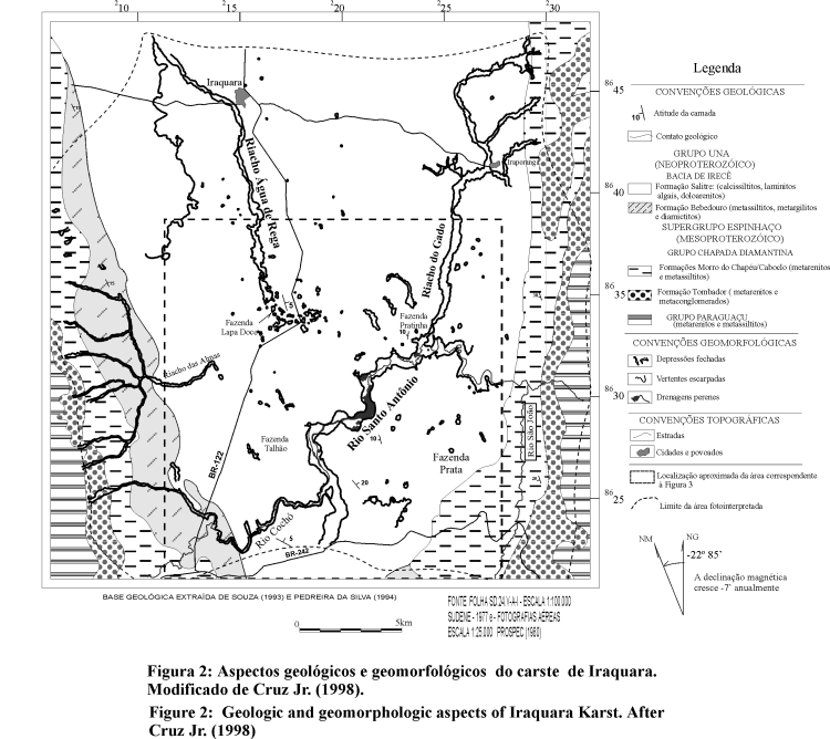
Geological context
The site is found at the south of one of the major
exposures of carbonate rocks in Bahia, geologically known as the Irecę sedimentary basin
(Souza et al., 1993). The carbonates in this basin belong to the Salitre Formation of the
Una Group within the proterozoic Săo Francisco Supergroup (Inda & Barbosa, 1978). The
Salitre Formation is composed of units of calcilutites, oolitic to pisolitic calcarenites,
dolomitic limestones, and dolomites which are described as doloarenite and dololutite.
According to Souza et al. (1993) and Dominguez (1996), the different types of rocks belong
to facies of carbonate sedimentation in shallow sea up to the continental rise.
These rocks occur in large-scale folds which form
open anticlines and synclines of variable dimensions from a few km to a few tens of km,
whose axes are mainly oriented NNW-SSE (Dandefer Filho, 1990). In the Iraquara region the
carbonate sequence occurs in up to 20 km wide synform, and the rocks usually have shallow
dips between 5° and 10° , but which can reach up to about 40° . Outcrops around the
carbonate sequence include siliciclastic sediments of the Bebedouro Formation, which also
belongs to the Una Group, and of the mesoproterozoic Chapada Diamantina and Paraguaçu
Groups (Pedreira da Silva, 1994).
Geomorphological context
The Iraquara region is situated in a karst plateau
with altitudes between 600 and 800m and smoothly undulating relief. The karst plateau is
surrounded by hill ranges which reach 800 to 1.200m whose upper parts have a morphology
which is developed in meta-arenities of the Tombador Formation of the Chapada Diamantina
Group and forms the domain of the Gerais plateau (Pedreira & Rocha 1999: Site 31, this
work). The Pai Inácio and Camelo Hills at the southwest limit of the area are well-known
examples of the typical geomorphological features of this domain.
Differences of level of up to 500m from the top of
the meta-arenites hills favour the development of the surface and underground drainage
systems onto the karst plateau, especially towards the valley of the Santo Antônio river.
This river, an important tributary of the Paraguaçu river, is the main drainage of the
plateau and corresponds the local hydrological base level. A considerable number of
resurgences and karst springs, such as the Pratinha resurgence near the confluence of the
Santo Antônio river and the Gado stream, occur along the margins of the karst plateau
(Figure 2).
The karst plateau typically has well-incised
drainages with near-vertical margins whose heights sometimes exceed 40m. Some of these
valleys, such as those of the Água de Rega and das Almas streams in the northwestern part
of the area, do not reach the Santo Antônio river, but form important blind valleys which
reflect stream capture by cave systems.
Closed depressions stand out in the local relief
due not only to their being the commonest karst feature in the region, but also to the
diversity of geomorphological types present. These range from simple dolines a few meters
in diameter to large compound dolines and uvalas with major axes over 1 km long. Cruz Jr.
(1998) presented an analysis of the distribution, shapes, orientations and surface areas
of 837 depressions distributed over an area of 492km2 (1.7 depressions/km2)
between Iraquara at the northern limit and the BR-242 at the South.
The caves are usually reached through dolines
formed by subsidence or collapse. Roof breakdown has been very important in the
segmentation and partial destruction of caves in the area. The best example of this is the
alignment of collapse dolines above the Lapa Doce and Lapa da Torrinha caves which
apparently mark the continuation of the valley of the Água da Rega stream. A statistical
correlation between the orientations of the axes of depressions and of duct segments
demonstrates that the must be a direct association between the distributions of caves and
of sink dolines in the area (Cruz Jr., 1998).
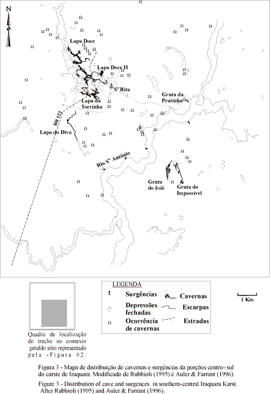
Underground
Although they are encountered throughout the karst
plateau, the caves occur mainly in the south-central part of the area, especially between
the sinks streams of the Água da Rega and das Almas and the left bank of the Santo
Antônio river (Figure 2). Other important examples occur near the resurgences of the
Pratinha stream, the Santo Antônio or Preto river and in the southeastern part of the
area.
The Lapa Doce and Lapa da Torrinha cave systems
which are located near the Água da Rega sink stream are the longest known with lengths of
17.0 and 8.3km respectively (Panchout & Panchout, 1995). The Lapa Doce system,
considered until then to be one of the ten largest in the country, was separated by
Rubbioli (1995) into the Lapa Doce (6.5km) and Lapa Doce II (9.8km) on the grounds that a
collapse dolines breaks the continuity between the two systems. According to Rubbioli's
(1995) survey, other large caves are Lapa da Diva (3.9km) and the Căo-Talhăo system
(3.0km) further south, Ioiô (4.0km) and Impossível (2.3km) to the southeast on the right
bank for the Santo Antônio river, and the Gruta Azul (1.5km) near the Pratinha resurgence
(Figure 3).
There is a great diversity of cave planviews
throughout the area. It is thought that the largest cave systems are mainly formed by
recharges from allogenic surface drainages coming from the arenite hills. In this respect,
the Água da Rega and das Almas streams stand out. The Lapa Doce and Lapa da Torrinha
systems have large galleries which in many places have heights greater than 50m and widths
greater than 15m. The channels which define the general distributary pattern for these
galleries (Ferrari, 1990; Cruz Jr., 1998). In other large systems, such as the Gruta da
Diva and Impossível systems, the main channels are narrower and have few branches.
Caverns with large single passage formed by breakdown such as Zé Libano, Jaburu,
Santa Marta, Conceiçăo and many others, are the commonest types. They usually have
beautiful, large entrances which lead to big rooms whose branch-off channels are
frequently blocked by rock falls or sedimentary deposits. Caves with a network pattern
mainly occur close to the banks of the Santo Antônio river near to karst resurgences. It
is probable that, as the mapping of caves progresses, many caves of this type will come to
be included with the largest caves of the area.
Most of the Iraquara caves are dry or drained by
intermittent streams. Nevertheless, lakes and perennial rivers of great scenic beauty are
encountered where the processes of formation and amplification of channels are in full
activity. The Gruta Azul-Pratinha, Ioiô, Impossível and da Diva cave systems have the
main examples of this type. Some of these cavities, such as the Gruta Azul- Pratinha
system, need to be mapped by cave-divers.
Dry galleries have a large collection of
speleothems with so many different forms that it is impossible to describe all of them
here. Calcite precipitates are the most common which occur as stalactites, stalagmites,
columns, and travertines among other forms. Aragonite is also commonly encountered
in various forms. The cave which at present stands out for the variety and composition of
its secondary chemical deposits in the Torrinha Cave, in which are found less popular but
equally singular and beautiful forms such as volcanoes, aragonite flowers and the largest
deposit of gypsum needles known in Brazilian caves. Some examples are more than 50cm long.
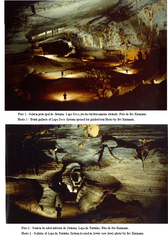
The ideas on the morphological evolution of the
caves in the region are mostly restricted to the morphological and geo-speleological
observations of the Lapa Doce (photo 1)and Lapa da Torrinha (photo 2) systems made by
Ferrari (1990), Cruz Jr. (1998) and Laureano (1998). Apart from the mainly NW-SE
orientation of distributary channels cited above, stretches with reticulated or interlaced
loops were found by Cruz Jr. (op. cit.) who analysed both channel geometry and paleoflow
systems. The junction between distribution branches and main channels may occur at floor
level or at different heights from the floor, which shows that different channel levels
are present in these systems. Labyrinthine webs of channels are found a few meters below
the base of the main channel, and constitute the only stretches of these cave systems
which are temporarily or permanently under water.
The model for cave genesis presented by Cruz Jr.
(1998) for the Lapa Doce and Lapa da Torrinha systems involves a multiphase evolution from
initial opening and enlargement to infilling by sediment deposits and finally sediment
removal and erosion of channels. The opening phase involves phreatic initiation of the
channels, while the enlargement phase consists of the normal incising of the channels
followed by changes of the base level in the Santo Antônio river. The infiling phase
involves substantial sedimentary clogging by clastic sediments up to the cave roofs along
almost entire extension in these systems, and resulted in morphological changes caused by
paragenetic processes which accompanied the rise of the eustatic water level forming half
tubes, ceiling pockets and pendants mainly at cave roofs. Finally, the sediment removal
phase involved partial erosion of the sediments forming channels which in some places have
banks more than 20m high and that comprised the passages which are presently being
explored. It is important to note that many stretches of galleries have been completely
modified by wall or roof collapse which leaves expressive piles of blocks and slabs. In
this respect the White Room of the Lapa da Torrinha stands out. Here a gallery wider than
100m contains piles of blocks more than 20m high.
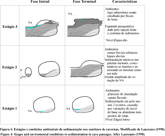
The stratigraphic analysis carried out by Laureano
(1998) on this important quaternary sedimentary register on the Brazilian continental
points to the participation of various depositional environments during the filling of
channels. The facies associations indicate that, from the base to the top, the typical
subterranean river deposits were formed in channels and floodplains followed by brief
episodes of flooding in ephemeral rivers and finally by the injection of clay-rich
sediments into the flooded channels (figure 4).
Preservation measures
The Marimbus-Iraquara Area of Environmental
Protection (APA) constitutes an area of permanent preservation which was implanted by
State Law no. 2.216 pf 14 June 1993. It has an area of 1,234 km2 and includes
parts of the municipal areas of Iraquara, Lençois, Andaraí and Seabra. The Pai Inácio
Hill, the Marimbus swamp land and the karst plateau in the Iraquara region are scenic
attractions within this area.
The tourism planning agency BAHIATURSA presented a
plan for ecological and economic zoning in 1998, and after this a plan for protection of
the speleological park and the promotion of activities in substitution of agriculture is
areas above the caves was conceived, with disciplined occupation and use of the land
integrated with the promotion of tourist activities. To achieve this the establishment of
a Zone of Protection of Caves, a polygon of 13 x 15km in the centre of the karst plates,
was foreseen. In this zone, the use of land in the area of influence of the caves over a
distance of 250m is restricted to scientific research and ecological tourism along a
network of footpaths with controlled access which will depend on the possibilities of
sustaining the area.
The management of the Marimbus/Iraquara APA is a
new challenge for BAHIATURSA, and is based on Cupertino between federal, state and
municipal governments together with participation of the population, through a
consultative council which will accompany the project.
References
AULER, A.S., FARRANT, A.R. (1996) A brief
introduction to karst and caves in Brazil. Proceedings of University of Bristol
Spelaeological Society, v.20, n.3, p. 187-200.
AULER, A.S. (1999) Karst Evolution and
Palaeoclimate of Eastern Brazil. Bristol U.K.: University of Bristol. (Ph.D. Thesis)
BAHIATURSA. (1998) Plano de Manejo da Área de
Proteçăo Ambiental Marimbus-Iraquara - Síntese. Salvador. 59p.
CRUZ JR., F.W. (1998) Aspectos geomorfológicos
e geoespeleologia do carste da regiăo de Iraquara, centro norte da Chapada Diamantina,
Estado da Bahia. Săo Paulo: Instituto de Geocięncias, Universidade de Săo Paulo.
108p. (Dissertaçăo de Mestrado)
DANDEFER-FILHO, A. (1990) Análise estrutural
descritiva e cinemática do Supergrupo Espinhaço, na regiăo da Chapada Diamantina, BA.
Ouro Preto: Escola de Minas da Universidade Federal de Ouro Preto. (Dissertaçăo de
Mestrado)
DOMINGUEZ, J.M.L. (1996) As coberturas
plataformais do Proterozóico Médio e Superior. In: BARBOSA, J.S.F. & DOMINGUEZ,
J.M.L. Mapa Geológico do Estado da Bahia - Texto Explicativo. Superintendęncia de
Geologia e Recursos Minerais. p. 105-142.
FERRARI, J.A. (1990). Interpretaçăo de
feiçőes cársticas na regiăo de Iraquara - Bahia. Salvador: Curso de
Pós-graduaçăo em Geocięncias, Universidade Federal da Bahia. 96 p. (Dissertaçăo de
Mestrado)
GUERRA, A. M. (1986) Processos de
carstificaçăo e hidrogeologia do Grupo Bambuí na regiăo de Irecę - Bahia. Săo
Paulo: Instituto de Geocięncias da Universidade de Săo Paulo. (Tese de Doutorado)
INDA, H.A.V., BARBOSA, J.F. (1978) Texto
explicativo para o mapa geológico da Bahia em escala 1:100.000. Salvador: SGM/CPM.
137p.
LAUREANO, F.V. (1998) O registro sedimentar
clástico associado aos sistemas de cavernas Lapa Doce e Torrinha, município de Iraquara,
Chapada Diamantina, BA. Săo Paulo: Instituto de Geocięncias, Universidade de Săo
Paulo. 99p. (Dissertaçăo de Mestrado)
PANCHOUT, P.Y., PANCHOUT, J.F. (1995) Brasil -
aventures spéléo souis les tropiques. Havre: SNAG/Oceanigraphique. 171p.
RUBBIOLI, E.L. (1995). Iraquara - um novo paraíso
espeleológico. O Carste, v. 7, n.3, p. 4-10.
SOUZA, S.L., BRITO, P.C.R, SILVA, R.W.S. (1993)
Estratigrafia, sedimentologia e recursos minerais da Formaçăo Salitre na Bacia de
Irecę, Bahia. Companhia Baiana de Pesquisa Mineral, v. 2, p. 1-24. (Série
Arquivos Abertos)
TRICARD, J. & SILVA, T.C. (1968) Estudos de
geomorfologia da Bahia e Sergipe. Salvador: Fundaçăo para o Desenvolvimento da
Cięncia na Bahia e Imprensa Oficial da Bahia. 167p.