Abstract
The large Brejões Cave is situated in the northern part of the Chapada Diamantina in
Bahia. It was formed in Neoproterozoic limestones of the Salitre Formation of the Una
Group, along the Jacaré River Valley at the northeastern margin of the Irecê sedimentary
basin. The cave is formed by the two segments: Brejões I and II, which together are 7,750
m long, and are separated by a collapse canyon. The karst canyons host flora and fauna
different from those of the surrounding caatinga, and form a special countryside which is
both beautiful and has an ecological significance. The cavern stands out in the national
speleological context for the sheer size of its galleries and of its speleothems, by the
volume of its collapse dolines, and by its impressive 106 m high entrance. All these
features have tourist appeal and were the motive for the creation of the Gruta dos
Brejões/Vereda Romão Gramacho APA (protected area). Its scientific importance lies in
the information on Quaternary paleoclimates which the study of its chemical deposits and
fossiliferous sediments may reveal. Large religious meetings are held under its vault, and
as popular cultural manifestations show that the cave has been democratically elected to
its present place in the regional picture. While the cultural value cannot be denied, the
depredation which accompany such huge meetings must be kept to a minimum.
Introduction
The Brejões cave is an outstanding geomorphological feature of the central-northern
region of Bahia State. It has very large subterranean fluvial galleries which contain
groups of large speleothems. Its scenic value can be judged even from Brejões da Gruta
village, where the cave entrance, over 100 m high, causes considerable impact. Inside the
cave, conduits up to about 150 m high have skylights formed by collapse dolines which are
up to 100 m in diameter.
In the context of the country's caves, its scientific, historic and cultural relevance
is demonstrated by the paleontological deposits which have already been worked, as well
as, the promising conditions for new discoveries, and also by the potential of
archeological studies as suggested by the findings of rock paintings at the cave entrances
and along the collapse valleys.
A point of special interest in the countryside at the surface is the contrast between
the caatinga, which dominates the peneplaned (flat) surfaces of the watersheds, and the
features found along the Jacaré river, which include the cave with a subterranean stretch
of the river together with the segments formed by collapsed galleries forming canyons and
dolines, in which the prevailing, more agreeable climatic conditions permit the survival
of more exuberant vegetation which remains green the year long, and which is a refuge for
the fauna, especially the birds.
The value of the Brejões cave receives popular recognition in the form of the
religious ceremonies held there, which attract thousands. The natural relevance of the
cave is now expressed by the creation of the Environmental Protection Area, a conservation
unit known as the Gruta de Brejões/Vereda do Romão Gramacho APA.
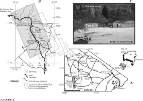
Figure 1: Localization of the Brejões cave. A) Access roads; b)
Hydrographic network and limits of the APA Gruta de Brejões/Vereda Romão Gramacho; c)
The 106m high entrance, seen from Brejões da Gruta village.
Localization and Physiography
The Brejões cave is situated in the northern Chapada Diamantina (in the so called
"Dry Polygon" ) within the central-northern part of Bahia State, at about 500 km
from the capital city, Salvador (figure 1). The cavern is formed in the Jacaré river
valley, also known locally as the Vereda do Romão Gramacho, a tributary on the right bank
of the São Francisco river. Its site lies close to the intersection of the Morro do
Chapéu, João Dourado and América Dourada municipal boundaries, at latitude 11o00'42.7"S
and longitude 41o25'59.6"W. The Chapada Diamantina National Park lies
about 150 km to the South.
In the geomorphological unit of the Jacaré river lowland, the climate is hot and
semi-arid, and altitudes vary between 480 and 560 m. The vegetation is a tree- and
shrub-caatinga. Karst valleys with high limestone scarps are a feature of this unit. The
more exuberant vegetation along the Jacaré river valley, with its great floral and faunal
diversity, is due to the perennial nature of the river. The land use in the area is
severely restricted by the predominantly shallow soils (eutrophic and lithic cambisoils)
which are very stony on the steeper slopes (Rocha & Costa, 1995).
The cave lies in the northern part of the eastern border of the Irecê sedimentary
basin, where carbonate sequences with minor intercalations of continental detritic
sediments of the Salitre Formation predominate. This formation is a neoproterozoic unit of
the Una Group, part of the São Francisco Supergroup (figure 2). The cave is formed in
gray laminated calcisiltites with fine intercalations of algal laminations belonging to
the Lower Nova America Subunit, probably related to the beginning of the first of the four
depositional cycles which formed the Salitre Formation (Pedreira, 1993).
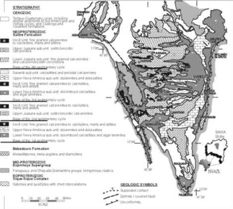
Figure 2: Geology of the Irecê basin, compiled by Pedreira (1993)
Historical aspects
According to the local population, the Brejões cave was discovered in 1877. The first
attention must have been given to the geomorphological exuberance of the cave region, but
soon after, the great paleontological value of its sediments was recognized. The first
discoveries inside the cave were published in 1938 by Father Camilo Torrendt, but a large
part of his collection was lost, according to Cartelle (1983).
In 1967, student members of the Caving Group of the Ouro Preto School of Mines decided
to traverse the 1800 km which separate south-central Minas Gerais State and
central-northern Bahia, in order to explore and survey the cave (Le Bret, 1975). In 1977,
systematic studies by members of the paleontological group of the Catholic University of
Minas Gerais commenced. More than five thousand items were collected, belonging to sloths,
giant sloths, mastodonts, armadillos, ant eaters, horses, rodents, and birds, among others
(Cartelle, 1983).
In 1995 the Geological Survey of Brazil (CPRM) described and mapped the cave as part of
the Morro do Chapéu Municipal Map, an institutional program aimed to offer basic
orientation for Municipal Planning. The survey undertaken by this project prepared a map
of the cave, and described its internal zoning, dictating use and conservation measures
including access restrictions based on existing physical parameters and a preliminary
evaluation of the hipogean fauna (Berbert-Born & Horta, 1995). This material has been
the basis of the Management Plan for the Gruta de Brejões/Vereda Romão Gramacho APA.
Socio-cultural and legal aspects
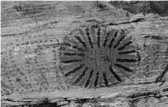
Figure 3: Example of rock paintings along the Jacaré River valley.
(photograph by I. Karmann).
Religious manifestations are common in the cave, and reveal aspects of popular cultures
which are in general ruled by natural and socio-economic conditions which stimulate
religious feelings. Some of the best known examples are found in very poor regions, such
as in the interior of Bahia and Goias States, and attract thousands of followers.
Sensitive relationships between faith, subsistence and natural degradation are generated
around the celebrations, and their analysis requires case-by-case treatment.
A religious festival which attracts thousands is held annually in the Brejões cave.
Even though the available spaces are large, environmental damage is very obvious. Groups
of speleothems are irreversibly damaged by breakages and by footsteps. A large quantity of
rubbish and residues of offerings are left in the cave. Apart from the processions,
Brejões receives smaller but equally uncontrolled visits throughout the year.
Other visible signs of human actions in the cave result from the scientific research,
especially the paleontological investigations which leave behind pits, trenches and heaps
of excavated sediments. Conservation of the sediment samples obtained during these
excavations, and which could be used later for sedimentological and estratigraphical
investigations aimed at paleo-environmental studies, leaves a lot to be desired.
The concern about damage to the cave environment is reflected by the current
legislation on this theme. Federal Decree no 99,556 of 01/10/1990 states
that "any natural subterranean cavity which can be reached by man is Brazilian
cultural patrimony and as such will be preserved and conserved to allow
technical-scientific studies and research, as well as speleological, ethnical-cultural,
touristic, recreational and educational activities to be undertaken", adding the
condition that its use and area of influence must obey conditions which assure its
physical integrity and the maintenance of the local ecological equilibrium. The study of
the environmental impact of any action which is potentially directly or indirectly
damaging is obligatory (2nd and 3rd Articles).
The environmental protection area around Brejões cave has an area of 11,900 ha (figure
1). Its supervision and fiscalization were attributed by State Decree 32,487 of 13/11/85
to the Environmental Resources Center of Bahia State (CRA).
Apart from the recent and damaging human remains, Brejões also has much older
registers of man's presence in the form of cave paintings and historic inscriptions near
the resurgence of the river and at points along the valley scarps, which have not been
sufficiently studied (figure 3). It is worth mentioning that rock paintings are now
considered as being much more than a simple demonstration of the necessities of simple
survival, and are also an artistic expression of cultural features (Barberi, 1995). They
are part of the register of the evolution of human conscience and intellectuality.
Figure 4: The entrace to Brejões Cave. At the lower left corner of
the entrance, the human figure gives a notion of the scale. (Photograph by E. L.
Rubbioli).
Description
Generalities
The Brejões cave is one of the most outstanding in Brazil for the large scale of its
galleries, saloons, skylights, speleothems, and its main entrance (figure 4). A karst
canyon formed by collapse divides the cave into the Brejões I and Brejões II segments,
which together have a length of 7,750 m (figure 5). Rock shelters and cave painting are
found along the canyon.
Brejões I is the main part, along whose 6,570 m are concentrated the most impressive
speleothems and morphological features which include two collapse dolines which form
enormous skylights. These are cylindrical features whose bases are wider than the tops
whose diameters reach 100 m. The cylinders are occupied by rock-falls , while their walls
are supported by pillars (figure 6).
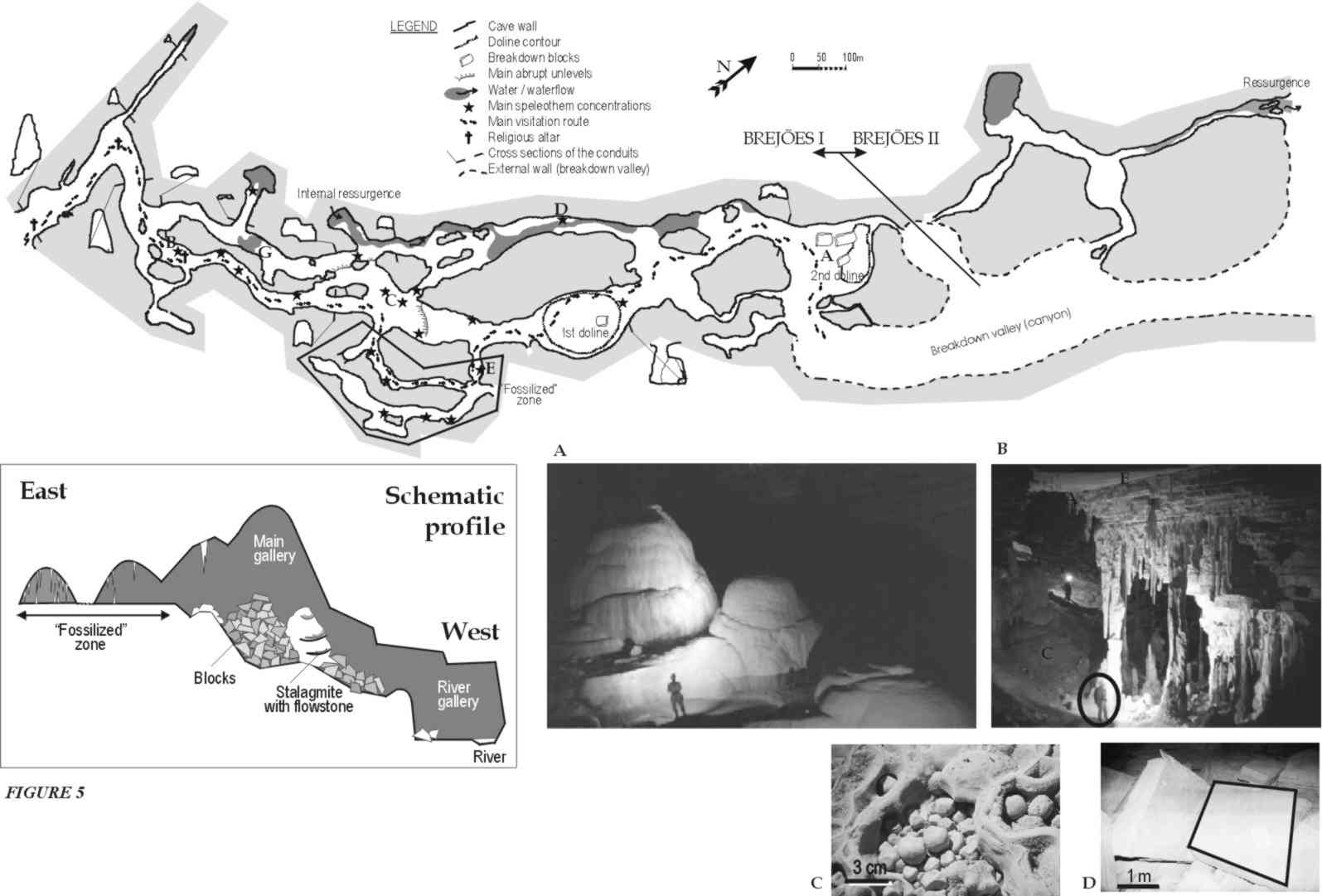
Figure 5: Plan, transverse sections and a schematic profile of Lapa dos
Brejões I & II; a) Large-scale stalagmites and travertine dams, with a human figure
for scale; b) A group of stalactites, stalagmites, columns and calcite flowstones, with a
figure for scale; c) Detail of nested calcite cave pearls in a travertine dam; d)Tabular
blocks fallen into the river conduit, emphasizing the rectangular shape. (Photos by M.
Berbet-Born).
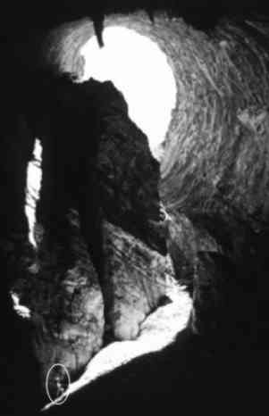
Figure 6: The collapse doline of the 2nd skylight. Note the stalactite
near the upper border of the photo, and the figure for scale in the lower left corner.
(Photo by M. Berbet-Born).
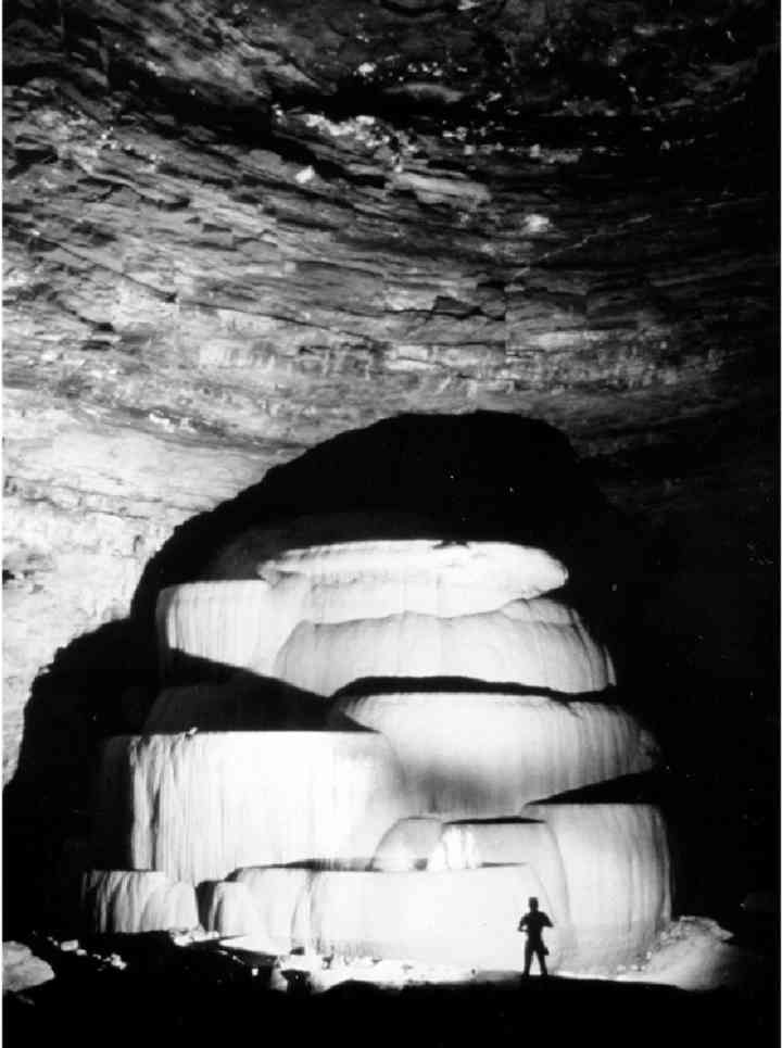
Figure 7: Travertine dams, "wedding cake" or the
"altar", one of the main spelethems of the cave, and an exceptionally fine
national example of this type of speleothem. It is undergoing depredation through the
accumulation of candle wax, breakages and scribblings. (Photo by J. Allievi).
Brejões I is up-stream above the canyon. The Jacaré river disappears down a sinkhole
about 300 m from the main entrance, and reappears inside the cave at about 750 m from the
entrance. From this point, it runs North-South along the entire westernmost gallery up to
a siphon near the second skylight. Flow is gentle and perennial, with several stretches of
slack water.
The river reappears inside Brejões II, and regains the open air about 300 m further on
at the entrance to Brejões II. From here on the river flows for several km through
scarpments which were probably formed by collapse of conduits. At least two currently
undescribed cavities are pesent down-river.
A number of apparently-stagnant pools occur at the lowest points in the galleries
inside the cavern. These show the direction of the inaccessible part of the river, since
they correspond to the phreatic zone of the cavity.
Morphology
Brejões I is formed by two mains sub-parallel galleries whose heights reach 80 m, and
whose widths are up to 150 m. These conduits are mainly rectilinear, but have some sinuous
stretches. The general direction is around N30E.
The connections between the two galleries lend an anastomosed geometry to the plan.
Wide halls occur at the intersections, with steeply-stepped floors since each conduit
develops its own topographic level. The roofs at the intersections are circular cupolas.
The eastern conduit is the larger and was an earlier river course. Transversal cuts
have regular lateral walls without levels or benches, with either essentially triangular
cross-sections such as that of the main entrance, or rectangular to square cross-. Going
down-river from the entrance, a N-S linear stretch suddenly turns to N60W within the
illuminated part of the cave. Within the penumbra, the eastern conduit branches off and
occupies a lower level. Both conduits gradually turn into the main NE-SW alignment.
Important accumulations of clastic sediments are generally found under fallen blocks in
the larger conduit. In turn, the blocks are covered by, or cemented by carbonate
concretions. One of the huge skylights occur in this main gallery, and is the extreme
product of collapse processes which have modified the original form of the conduit.
Small lateral branches are sometimes completely filled by clastic sediments.
The second smaller conduit has mainly polygonal cross sections. Piles of fallen blocks
also occur in this conduit, but their volumes are smaller and the blocks are rectangular
slabs rather than the cubes found in the main gallery.
After its resurgence the river runs along the western cavern wall, forming the youngest
environment within the cave which is undergoing active incision.
Speleothems
As well as its size, Brejões is also exceptional for its large speleothems. Some
groups of stalagmites, calcite flowstones and travertine dams or (popularly called
"wedding cakes") are outstanding in size and beauty. They are up to 10 m high
with diameters larger than 5 m, and have well defined border basins up to 2 m deep. One of
the most impressive formations, the "altar" (figure 7), is used to receive
offerings, and thousands of candles are lit here. The accumulation of dark candle wax is a
factor which has led to its depreciation.
In some places the travertine dams occupy large areas of the gallery floors. Taking
into account their size, the site of growth of these dams indicates places where vadose
waters have flowed for some time in direction of the base level. At least four points of
this type are seen in the older main gallery. One point is close to the altar, another
point is further ahead and supplies the material for the concretions on the floor close to
the entrance, while the other two are situated in the median stretch which includes the
main inter- gallery connections. From the last point, the concretions are spread over
various directions on the way to the conduit now occupied by the river.
Large scale flowstones coming from the highest point of the roof near the first
skylight formed deposits over a thick pile of clastic sediments. Other ornaments include
cones found in a travertine dam basin which is now dry, stalactites up to 13 m high, and
delicate 'corals', nests of cave pearls, cave straws and helictites (figure 5 a, b, c). In
stagnant water, floating crusts or rafts proliferate.
The greatest concentration of speleothems is found in two small galleries parallel to
the main galleries at the eastern end of the cave (figure 5). Almost no chemical
precipitation is occurring at present in this area, which is already outside the area of
influence of the river. The groups here are quite phenomenal: flowstones, curtains,
stalactites, stalagmites, columns, coraloids (like cauliflowers) and travertine dams, in
combinations which occupy the roof, the walls and the floor, with dimensions from a few mm
to various m.
Aspects of the cave evolution
The cave is part of the Bambuí Speleological Province in Irecê District, according to
Karmann & Sánchez' classification (1979). It is formed in grey laminated
calcisiltites of the neoproterozoic Salitre Formation of the Una Group.
Neither the internal sedimentary deposits nor the micro- to meso-scale morphological
features have been studied in sufficient detail to allow the establishment of the erosive
and depositional dynamics of the Jacaré river, which is the principal agent responsible
for the opening of the cavern.
The general evolutionary lines can be set up by analysis of the organization of the
gallerieis, of some morphological features, and of the distribution of some of the
sedimentary components, which together show that the water course responsible for
sculpting the cave underwent changes of its course and drainage direction during the
foundering of the regional base level. This model has to be compatible with those
established for the regional geomorphological and climatological evolutions.
The parallelism of the main galleries shows that evolution was from east to west, the
galleries having developed by laterally entrenchment along progressively lower
stratigraphical horizons in the W/NW direction, until the conduit along which the river
presently runs is reached, as shown in the profile of figure 5. Ancient meanders can be
recognized in some stretches of the galleries, which may have been formed as a result of
seasonal or longer-term changes of the flow rate, or by bed migration due to
sedimentation. At present changes in the river flow are responsible for the formation of
flood plains where fallen blocks are being eroded.
Long stretches of former galleries are completely blocked by clastic sediments which
may well be related to phases of detritus flows discovered in the Iraquara caves by
Laureano (1998).
The recent river down cutting observed in the lower gallerieis appears to be evolving
laterally rather than vertically. The predominantly tabular fallen blocks in the lower
cave levels contrast with the approximately cubic blocks of the upper levels, and cave
cross sections with horizontal long axes in the lower sections can be attributed to
lithological control. In the lower levels, the rocks have a finer and more penetrative
lamination defined by stratification and clay intercalations , while the rocks of the
upper levels are more massive and less laminated.
In a general fashion, structural control is shown by the presence of sub-vertical
fractures present at small scale and in the rectilinear stretches of wide galleries and in
the collapse valley. The sinuous and curved pattern with anastosmosed stretches in the
lower conduits show that the enlargement of the cave took place preferentially along the
bedding planes of the rocks.
With the present data it is possible to interpret a syngenetic evolution of the cave in
terms of a phase of phreatic initiation and enlargement, poorly developed or poorly
accessible at the top of the conduits, followed by vadose down-cutting up to depths of 80
- 100 m, accompanied by lateral broadening up to a width of about 100 m. The original
morphology of the conduits is poorly preserved, the collapsed form predominating.
Sediments and fossil material
A step about 15 m high in the floor of the main gallery is the result of erosion of a
thick sedimentary deposit formed by poorly-sorted clastic sediments covered by chemical
concretions and speleothems.
The sedimentary pile, still undescribed from a sedimentological point of view, hosts an
important accumulation of fossils represented by the material collected by PUC - Minas
Gerais research workers in 1977. About 1,500 pieces belonging to 17 examples of Paleolama
sp (lhama), 6 samples of the sloth Nothrotherium maquinense and Eremotherium
laurillardi, the giant sloth, parts of 3 examples of the giant armadillo Glossotherium
(Ocnotherium) giganteum, 4 individuals of Pampatherium humboldti
(giant armadillo), 1,000 pieces of birds, 2 exemples of Mymecophoga tridactyla
(ant-eater), Coendou sp. (hedgehog), Lutra sp. (otter), rodents, deers,
mastodonts, hogs, horses, tapirs and bats (Cartelle, 1983)
Environmental impact and suggestions
A number of relatively well-marked trails and one main route have been established
along the cavern, over the rock falls and speleothems, and represent easy transit between
the main entrance and the canyon, passing the two skylights (figure 5a). The large choice
of routes allows easy access to a number of stretches of the cave which are only partly
naturally lit, or are dark. Wall scribbling and rubbish are found along all these
stretches, but are concentrated in the lighter parts, or along the main route.
A number of rudimentary altars which receive icons, statues, candles and offerings,
attract larger agglomerations of people. It is thought that no restrictions on the altars
already set up in the entrance vault are necessary, since the site is sufficiently large
to accommodate the large number of people. Orientation about scribbling, rubbish and the
use of fireworks is, however, essential. The situation of the altar set up on the large
"wedding cake" stalagmite about 500 m from the entrance is entirety different.
This speleothem is recognized as one of the main features of the cavern, and represents
one of the major underground ornaments of this type in Brazil. The stalagmite is in a
restricted space, insufficient for large groups of people, and the delicate outlines of
the travertine dams are being destroyed.
Another locality which is being seriously damaged is the "fossil stretch" in
the southern galleries, with its major concentration of speleothems. Transit here should
be restricted. Each group of ornaments should be carefully surveyed, and the stretch
should receive special zoning which restricts and supervises the visits. No modification
of the natural environment is necessary, neither by removal of the natural objects nor by
the introduction of artificial objects, since the simple solution of visits accompanied by
trained and equipped guides may be sufficient, both in this and other stretches of the
cave (Berbet-Born & Horta, 1995).
Is should be emphasized that for any type of management of the area, multidisciplinary
studies of environmental impact on the cave and its surrounding, including the flora and
fauna, are necessary. These studies should aim at a clear definition of the load capacity
of the system, special restrictions and measures necessary in time or in space. Finally,
the interests of the nearby communities must always be taken into account, and they should
be invited to participate in these studies whose results should always be directed towards
their benefits.
REFERENCES
BARBERI, M. 1995. Arqueologia. In: ROCHA, J.A. & COSTA,I.V.G. (org.) 1995.
Município de Morro do Chapéu (BA). Salvador, CPRM. p. 203-213 (Projeto Mapas
Municipais-Informações Básicas para o Planejamento e Administração do Meio Físico).
BERBERT-BORN, M. 1995. Lapa dos Brejões: Mapa de trilhas, acidentes, distribuição de
espeleotemas e impacto antrópico. In: ROCHA, J.A. & COSTA,I.V.G. (org.) 1995.
Município de Morro do Chapéu (BA). Salvador, CPRM. Mapa (Projeto Mapas
Municipais-Informações Básicas para o Planejamento e Administração do Meio Físico).
BERBERT-BORN, M. & HORTA, L.S. 1995. Espeleologia. In: ROCHA, J.A. &
COSTA,I.V.G. (org.) 1995. Município de Morro do Chapéu (BA). Salvador, CPRM. p. 158-202
(Projeto Mapas Municipais-Informações Básicas para o Planejamento e Administração do
Meio Físico).
CARTELLE, C. 1983. Tesouro fóssil no sertão baiano. Ciência Hoje, 1(5):36-43.
KARMANN, I. & SÁNCHEZ, L.E. 1979. Distribuição de rochas carbonáticas e
províncias espeleológicas do Brasil. Espeleo-Tema, 13(105-167).
KARMANN, I. & SÁNCHEZ, L.E. 1986. Speleological Provinces in Brazil. In: CONGRESSO
INTERNACIONAL DE ESPELEOLOGIA, 9. Barcelona, 1986. Comunicaciones... v.1 p.151-153.
LAUREANO, F.V. 1998. O registro sedimentar clástico associado aos sistemas de cavernas
Lapa Doce e Torrinha, município de Iraquara, Chapada Diamantina (BA). São Paulo, 98p.
(Dissertação de Mestrado, Instituto de Geociências da Universidade de São Paulo).
LE BRET, M. 1975. Merveilleux Bresil souterrain. Vestric, Editions de l’Octogone.
235 p.
PEDREIRA, A.J. (org.) 1993. Estratigrafia, sedimentologia e recursos minerais da
Formação Salitre na Bacia de Irecê, Bahia. Salvador, CBPM. 24p. (Série Arquivos
Abertos 2)
PINHEIRO, R.V.L. 1988. Nova Proposta para classificação de Províncias
Espeleológicas. In: CONGRESSO DE ESPELEOLOGIA DA AMÉRICA LATINA E DO CARIBE, 1. Belo
Horizonte, 1988. Anais...p.220-222.
ROCHA, J.A. & COSTA,I.V.G. (org.) 1995. Município de Morro do Chapéu (BA).
Salvador, CPRM. (Projeto Mapas Municipais-Informações Básicas para o Planejamento e
Administração do Meio Físico).