
SIGEP
Geological and Paleontological
Sites of Brazil - 015
THE LAGOA SANTA
KARST
Date: 15/02/2000
Mylène Berbert-Born
e-mail:
berbert@zaz.com.br
CPRM-Geological
Survey of Brazil
SGAN 603 Conj. J Parte A 1o andar
Brasília-DF 70.830-030
© Berbert-Born,M. 2000. The Lagoa Santa karst. In: Schobbenhaus,C.; Campos,D.A.; Queiroz,E.T.; Winge,M.; Berbert-Born,M. (Edit.) Sítios Geológicos e Paleontológicos do Brasil. Published
15/2/2000 on Internet at the address http://www.unb.br/ig/sigep/sitio015/sitio015.htm
[actually
https://sigep.eco.br/sitio015/sitio015english.htm]
[SEE PRINTED CHAPTER IN
PORTUGUESE]
(The above bibliographic reference of author copy rights is required for any use of this article in any media, being forbidden the use for any commercial purpose) |
ABSTRACT
Close to the North of Belo Horizonte, Center–South of Minas Gerais State, is one of
the most important Brazilian regions in terms of carbonatic karstic landscape and in terms
of the natural sciences history: the Lagoa Santa
Karst. This region presents a dense set of typically dissolutive features in
association with a hydrography with fluvial (subaerian) and karstic (underground)
components, developed in pure calcarenites (CaCO3>94%) of the Sete Lagoas Formation
(Bambuí Group) covered, on its major part, by significative pedological formations. The
surficial relief (exokarst) evolved from the primordial configuration of underground
hydric nets (endokarst) and from an intense dynamics at the interface rock/soil
(epikarst), which integration favoured the appearing of multiple points of capture of the
surficial waters according primary and secondary basins (coalescent dolines or sinkholes).
At the same time, a strongly irregular covered rocky relief is conformed, as verified by
apparent towers and warts in dissecated areas. Other common features are the big linear
cliffs – resulting from the dolines evolution – canyons, blind-valleys and collapse dolines placed in fluviokarstic segments, as well as
large lowered plains sazonally fooded (poljes).
The underground channels net, structurally controlled, is presently connected to surface
in most part, forming hundreds of caves. Paleontological sites of great value are
associated to this environment, with specimens of the extinct pleistocenic megafauna, and
also very important vestiges of the pre-historic human occupation in Brazil, among which,
bones aging around 12 thousand years described by Peter Lund as the “Lagoa Santa
Man”. The creation of an conservation unit called Environmental Protection Area (APA)
increases the value of the natural
and scientific patrimony and at the same time looks for to conciliate it with the
conditions of intense urban and industrial development of the region.
INTRODUCTION
The Lagoa Santa
region, localized near to Belo Horizonte, the State capital of Minas Gerais, is an
important Brazilian exemplary of a karstic environment developed in carbonatic
rocks.
Its typical and diversified karstic
geomorphology shows some special features:
i) a great quantity of dolines with
a variety of sizes, shapes and genetic patterns, usually limited by linear limestone
cliffs;
ii) big outcropping or partially
covered rocky massifs;
iii) many lakes with diverse hydric
behaviors, associated to the dolines or in large lowered plains, and
iv) a complex net of underground
channels, usually connected to the surficial
relief and, so, accessible to man. This conjunct of big exposed dissolutive features,
together with the small-scale dissolution forms (karren)
and the typical vegetation of the area, stands out an landscape with scenic merit, and
being so, with touristic interest.
Besides that, the karst of Lagoa Santa has academic importance due its beautiful examples
of integrated dynamic processes of dissolution, transportation, clastic deposition and
erosion at surface (exokarst), underground (endokarst) and at the interface rock-soil
(epikarst).
The karst of Lagoa Santa also has a special meaning for the Brazilian
people science and culture. It is considered the cradle of the Brazilian paleontology,
archaelogy and espeleology. The pioneer reserchs is originally justified by the great
quantity of caverns. The region has the greatest number of caves per area as known today
in the country, which preserves many pleistocenic fossils, including the so-called extint
megafauna, and the “most important traces of the pre-historic human occupation in
Brazil, with rupestrian paintings, tools and
bones, whose oldest registers age around 12,000 B.P.” ( Prous et al., 1998 ).
Another characteristic feature of the Lagoa Santa area is the intensive
anthropic occupation, what implies risk for its integrity. Besides its demographic
expansion, it represents an industrial and
mining center of great economic importance. This conflicting situation, with a growing
endangering of water, vegetation and relief, was a decisive factor for the establishment
of a local Conservation Unity, named APA Carste de Lagoa Santa (Environmental Protection
Area of Lagoa Santa Karst). The ecological-economic zoning realized by CPRM/IBAMA, in
1998, may be the start-point for a development in an harmonious coexistence with the
natural patrimony of the area.
LOCALIZATION AND PHYSIOGRAPHY
Definition
and situation
The Lagoa Santa Karst is a region situated
around 30 km to the North of Belo Horizonte characterized by a dense ensemble of tipically
dissolutive geomorphological features and by a drainage with fluvial (subaerial) and
karstic (underground) components (figure 1).
Most of the karstic area localizes between the Velhas river (to the
East) and the Mata stream (to the West-Southwest) and is limited to the South-Southwest by
the granitic-gneissic terrains of the crystalline bedrock. The limits to the North are not well defined, but
the karstic perimeter can be referred to the limits of the Environmental Protection Area
(figure 1), covering more than 350 km2 in the municipalities of Vespasiano,
Pedro Leopoldo, Confins, Lagoa Santa, Matozinhos, Funilândia and Prudente de Morais.
Some similar geomorphological and faciological belts extend to the
Northwest towards the city of Sete Lagoas, but they are not considered as belonging to the
Karst itself.
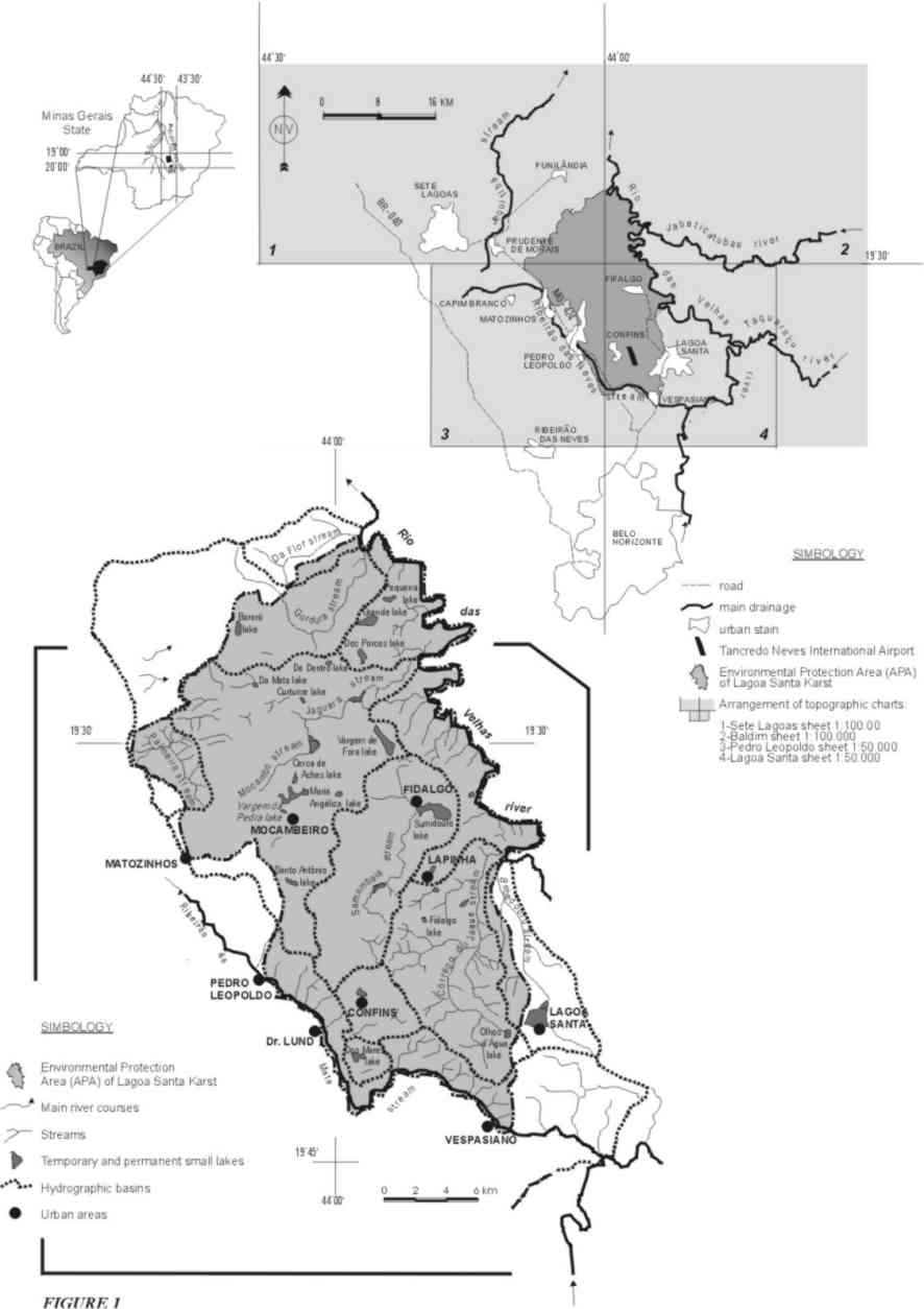
Figure 1: Localization and hydrgraphy
of the Lagoa Santa Karst.
Drainage and relief
The main
hydrographic sub-basins are related to the Samambaia, Palmeiras-Mocambo, Jaguara and
Gordura streams (figure 1). The limits of these basins are not well recognized, because
much routes of the underground flow are still unknown. All this drainage fall into the
Velhas river, which is representing the regional base-level.
The
main morfogenetic domains in this karstic region are defined by two physiographic features
described by Auler (1994) in the center-southern portion of the area: the Karstic Plateau
and the Mocambeiro Depression, with elevations ranging from 650m (the Mocambeiro plain and
Sumidouro locality) to 900m (Ferradores elevation).
Kohler (1989) recognizes rests of
the Sul-Americana Geomorphological Surface (Superfície Sul-Americana) in the high
residual plateaus, marked by elongated and convexed elevations in altitudes over 800m. The
dissecated portions of the karstic plateau are characterized in two different ways: 1) by
a strongly wavy relief, with pedologic cover, composed by various basins mutually
articulated according irregular polygons (single and coalescent dolines) coarsely aligned,
that conducts the surficial water flux (authigenic) to multiple points of infiltration
(Piló, 1998), and 2) by areas where big rocky massifs with karren are found. There are
also portions where canyons and blind valleys characterizes fluoviokarstic segments.
Several underground channels are intercepted by
the surface of the relief, and hundreds of caves with different morfology and dimensions
have been lifted. The more depressed areas appear as relatively large plains, with planned
bottom and recoilled abrupt slopes (poljes), occupied by temporary lakes or channels of
subaerial drainage.
Climate and vegetation
The average
temperature in the area is around 23º C, with a minimum-media around of 11.2º
C in the last period of 30 years ( in July ), and 29.6º C the maximum-media (
October through March ). The relative humidity ranges from 60 to 77% during the driest and
most humid months respectively. The average pluviometry is around 1,380 mm. The dry period
extends for about 5 months, from May thorugh September, with less than 7% of annual rains,
characterizing a typical tropical pluviometric regime, and a great concentration of them
in summer while winters are dried (Patrus, 1996).
The cerrado and the semidecidual stational forest are the main types of
vegetation in the region (IBGE, 1993). The cerrado
is restricted to remainned spots in regeneration or
in transition form (mata-cerrado). In the
dolines and around the rock outcrops the
semidecidual stational forest is the main vegetation form.
A decidual stational forest develops over the limestone outcrops (“mata-seca”) (Piló, 1998).
Geological background
The Lagoa Santa
karstic features was developed in neoproterozoic carbonatic lithotypes of the Sete Lagoas Formation, Bambuí Group. They outcrop in the far
Southeastern portion of the Precambrian Bambuí sedimentary basin, which belongs to the
São Francisco Craton (figure 2A).
The
local geomorphology reflects an stratigraphy marked by the succession of two different
carbonatic units (Sete Lagoas Formation), underlying very fine grained siliciclastic rocks
(Santa Helena Formation). This sedimentary succession lies in discordance in the Archaean
Gneissic-Migmatitic Complex (figure 2B). The Cenozoic elluvium-colluvium
lateritic-detritic covers which occur as
residual surfaces to the plainning stages also play important role in the karstic relief
structuring here described.
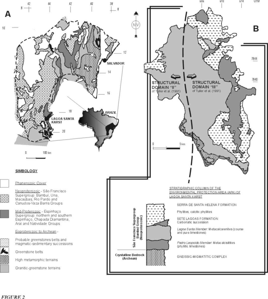
Figure 2: Geology. A) Localization of
the Lagoa Santa Karst in the sketch of São Francisco Craton (simplified from Almeida
& Hasui, 1984 and Alkmim et al., 1993); B) Lithoestratigraphic Map of Lagoa Santa APA
(Viana et al., 1998).
The stratigraphy
adopted in this paper is the one defined by Schöll (1976), modified by Tuller et al.
(1992), which recognizes seven depositional facies in the two carbonatic sub-units of the
Sete Lagoas Formation: the Pedro Leopoldo and Lagoa Santa members. Tectofaciologic
variations of the units have been also described in that last paper, besides the
lithofaciological variations, both of importance in the geomorphological structuring in
several scales.
According to those authors, the base
of carbonatic sequence is formed by siliceous or so-named “impure” limestones
with predominance of fine laminated calcisiltites and calcilutites and frequent thiny clay
intercalations. The clastic participation is more acentuated at the contact with the
crylstalline bedrock. Calcium carbonate grade is always under 90% and can reach 60%
(Campos, 1994; Piló, 1998). This unit can reach 80m thick (Campos, 1994; Tuller et al.,
1992).
A pack of very homogeneous calcarenites occur over the basal carbonates
(Lagoa Santa Member), with CaCO3 grades over 94% and more than 200m thick in
some places (Tuller et al., op.cit.). This is the unit more subjected to karstification.
The contact between both members is very irregular, and can be transicional or
interfingered, with intercalations of till 20m thick (Campos, 1994), or even rough. The
Pedro Leopoldo calcisiltites can occur over the Lagoa Santa calcarenites, although
restrictely.
The transition of the carbonatic to the pellitic sequence of the Serra
de Santa Helena Formation can also be transitional (Campos, 1994), or in discordance to
each other (Tuller et al., 1992). In some places the pellitic rocks rest directly over the basal calcisiltites.
The variable thickness of the units, their discontinuities, lateral and
vertical faciologic variations and the differences in their mutual contact relations are
thought to originated from the strongly irregular feature of the crystalline bedrock that characterizes the deposicional basin. Is
also noteworthy that the paleorelief of the basin also displayed an important influence on
the deformation arising out of tectonic movement, characterized by low angle
transportation of the supracrustal sequence over the crystalline bedrock (“epidermic” or
“thin-skinned” tectonics) from east to
west.
The described sequence is variably deformed and exhibits low-grade metamorphism,
with predominance of subhorizontal structures. So, the laminations and bandings correspond
to the tectonic foliations coincident with the original bedding, this latter already
transposed, specially in the oriental portion
of the area where the deformation is more intense. The frequent calcitic and siliceous
venulation observed according the transposition foliation reflects the great mobilization
associated to a ductile deformation. The movement direction is quite well expressed by a
very significant E-W mineral stretch lineation,
with a soft dipping to E.
The deformation appears to be more intense at the contact between each
of the units and at the base of the sequence, configuring inter and intralayers
shear-zones, maybe resulting from the bigger proportion of clayey intercalations functioning as
“lubrifying” agent, favouring the mass transportation.
Disruptive structures are specially
represented by families of high angle fractures (subvertical) whose frequency and
direction are variable over each lithotype and according to the structural or
deformational domain. One may note that in the non-homogeneous basal limestones the
structures associated to a ductile tectonics are
better expressed, as the plane-parallel to wavy laminations. In the superior gross-grained
and homogeneous limestones the structures are more of the rigid type, fracturing being
specially important and decisive in the configuration of the present relief. Among the
main ensembles, the E-W, N30-40E and N10-20W directions appear as the most prominent, but variations can appear according different
structural domains as mentioned before. Some major vertical slip or oblique faults have
been identified, and they are resposible for the individualization of the structural
blocks and for the alignment of the slopes and groups of dolines (Campos, 1994).
The units appear covered in general by colluvium with variable
thickness, that can reach 50-80m, according to drilling cores collected in the area (Campos, op cit.). The
biggest thicknesses are found over the siliceous limestones of the base of the sequence,
many times forming large plains sazonally floody.
Historical
Background
The many
archaeological records indicate an human occupation in the region back to at least 12,000
years ago (Prous et al., 1998). Bones, indigenous rocky artefacts, ceramics, bonfires
traces, engravings, and rupestrian paintings, are
found mainly in caves, shelters and by the cliffs.
Populations succeded occupying caves and shelters densely and
permanently (Prous et al., op.cit.), cultivating the soils and using the waters from the
lakes present in dolines. When the first
“european expeditions” arrived in the area, around 1675 with Fernão Dias Paes,
a rapid fragmentation of the local indian societies happened, specially because of the
presence of alluvium gold (Piló, 1998).
Later men returns to their relation
with the caves due the salpetre economic interest in the gunpowder fabrication (Gomes and
Piló, 1992). This brought to the discover of animals and human bones which called the
attention of the naturalist researchers of that time. From 1840 on records of the first
systematic explorations and studies in the caves realized by the Danish scientist Peter
Lund appear in literature. His researches projected Lagoa Santa region in the scientific
world, especially for the suspition of contemporanity of the pre-historic population known
as the “Lagoa Santa Man” and the extint fauna,
an pioneer idea at that time (Prous et al., 1998). Lagoa Santa became the “cradle of
the Brazilian archaeology and paleontology”.
Many other naturalists and travellers registered the landscape
atributes of the area after Lund. The archaeological and paleontological researches
promoted by the National Museum of Rio de Janeiro in the decades of 1920 and 1930, the
studies of the Minas Gerais State Academy of Sciences along 20 years, and the
American-Brazilian (decade of 50) and the French-Brazilian Mission (during the 70’s)
expeditions are among the most important. Lanari, Padberg-Drenkpol, Aníbal Matos, Arnaldo
Cathoud, Josaphat Pena, H.V.Walter, Hurt and Blasi, Souza Cunha, Paula Couto,
Laming-Emperaire are some of the most notable researchers in the area. From the
French-Brazilian Mission, the researches start to be conducted by Museum of Natural
History of the Minas Gerais Federal University, under A. Prous and C. Cartelle. In the
field of the geomorphological studies, Tricart, Barbosa, Journaux, Coutard and Kohler
appear among the most important scientists.
The sudies done in the area, also comprised descriptions of the caves
environment, their morphology, clastic and chemical sediments, and relations with the
upperground landscape. For this reason, the region is also considered the “cradle of
the Brazilian speleology”, specially because of Lund precursory studies. In 1937, the
foundation of the first Brazilian society of speleology is registered– the
Excursionist and Speleological Society SEE – associated to the
Ouro Preto School of Mines. They start the first specific works on exploration, mapping
and description toward the compreenhesion of the underground features of the terrains.
During the 80’s, several academic studies on geology,
geomorphology, hydrogeology, limnology and paleoecology are registered in monographies,
dissertations and thesis. Some speleological groups also make important actions. During
the 90’s, multidisciplinary environmental projects were developed by governmental
institutions (such as CPRM-Geological Survey of Brazil, CETEC-Technological Researchs
Center of Minas Gerais State and IBAMA-Brazilian Institute of Environment and Renewable
Natural Resources) in partnership with municipal administrations, based on previous
experiences brought with the construction of the international airport of Tancredo Neves,
in Confins.
The pressure of the economic development, vital to the region, in an
area of recognized physical fragility and of great scientific and cultural value,
culminated in the stablishement of an Conservation Unit (Federal Decree no
98,881 of 26/01/1990). The premisses for a sustainable coexistence are already
determinated trough its ecological-economic zoning.
DESCRIPTION
The Lagoa Santa
region presents terrains of karstic geomorphology, with an irregular relief concave-convex
type resulted from dissolution of carbonatic rocks and from the hydrographic structuration
with important underground components.
So, typical features are shown in
surface (exokarst) and in underground where a
net of channels with variable dimensions and shapes is articulated constituting the
endokarst. Such channels are accessible in surface, where they appear as caves, one of the
most representatives features of the area. A third domain is represented by the interface
rock/soil called epikarst. In all these domains there are specific components in different
scales which must be considered for a better characterization of the environment as a
whole.
Is should be emphasized the strong mutual vinculum among the surficial,
subsurficial and underground features, since the subterranean dynamics has a determinant
role on the configuration of the surficial relief, at the same time that the forms present
in surface are fundamental for the water circulation and for the sediments moving. The
dynamics of the dissolutive processes in the karstic domain has a reflex of especial
meaning in the configuration of the Lagoa Santa landscape, according to Piló (1998).
Exokarst
Several physiographic units and
subcompartments have been individualized in the region (CETEC, 1987; Kohler, 1989; Auler,
1994; CPRM, 1994; Piló, 1998): the Gorge and Abysms with High Cliffs unit; the Ouvalas
Belt unit; the Karstic Plateau; the Poligonal Karstic Plateau; the Residual Planaltic
Highs; the Dolines Plateau; the
Matozinhos-Vespasiano Plateau; the Covered Karstic Surface; the Phyllitic Surface; the
Lagoa Santa Lowered Surface; the Fluvial Plains; the Karstic Plains; the Mocambeiro
Ouvala; the Riacho do Gordura Megaouvalas with Lakes; the Sumidouro Polje.
The units that better characterize
the regional compartimentation, bringing together the dominant features in genetic
relation with the hydric system are those defined by Auler (1994). Among them the ones
which describe the karstic features are:
The Karstic Plateau
It defines the
areas with a strongly irrregular topography in altitudes of 850 and 700 meters, where
occur great concentrations of the main karstic features, such as the outcropping massifs,
the linear cliffs, towers and warts with karren. Dolines are very frequent, specially the
dissolution and subsidence (alluvium) types. In this compartment appear the Gorge and
Abysms with High Cliffs, the Ouvalas Belt and Dolines Plateau units individualized by Kohler (1989)
and Kohler et al. (1998) (figure 3A).
Fields of dolines characterize the
karst developed in areas covered by soils of variable thickness. They often form bigger
basins articulated according a celular net of irregular poligons with surficial radial
centripeter drainage and many multiple points of infiltration situated at the bottom of
the dolines (sinkholes). One important exemplar
of this configuration is the Macacos-Baú Poligonal Depression (Piló , 1998). According
to Piló (op. cit.), most of the dolines of that region have their basins limited by
limestone scarp. They are asymmetric half-circled, with flat or funilated bottoms.
Circular or oval dolines with asymmetric
slopes, with no rock outcrops are also frequent.
Expressive ensemble with groups of dolines and rocky massifs exposed or
semi-encovered also appear in the region of Lapinha, Lapa Vermelha, Cerca Grande and
Jaguara areas, Poções and proximities, the Ciminas mining region, the Cauaia farm and
Gordura areas (figure 3B). Some fluvial systems are present in combination with the
underground hydrologic systems, which are responsible for the modelling of canyons and
blind valleys as the ones in the Poções region, where collapse dolines are also common.
Some important alluvium plains in valleys of backward slopes are also
considered components of the Karstic Plateau, as some portions of the Palmeiras-Mocambo,
Samambaia, Jaguara and Gordura streams. The Samambaia stream plain deserves to be
outstanded in this domain, and to be even individualized, to represent one important basin
of discharge of the waters captured in the surrounding plateaus, conducted to the great
depression of the Sumidouro lake (Sumidouro polje), near to the regional hydric base-level represented by the Velhas river.
Karren, are furrows
and reentrances of milimetric to metric scale also considered as an particular karstic
feature that seem to differenciate from region to region. In the Lagoa Santa Karst, some
of the most notable forms of dissolution are those developed along the horizontal
foliation or bedding (schichtenkarren),
conforming lenticular or oval notches (figure 3C), usually a few centimeters to few
decimeters size, frequently repeated, and sometimes concentrated along specific horizons.
Vertical notches (rinnenkarren) are also common
(figure 3D).
The Karstic Plateau geomorphology is
strongly vinculated to the occurrence of the pure homogeneous limestones of the Lagoa
Santa Member. One distinctive characteristic among the relief developed over the calcitic
calcarenites and the siliceous calcisiltites, although capped by pedological mantles, is
the shape of the slopes of the hills which, according to Campos (1994), is gentler over
the siliceous limestones in comparaison with those on the calcisiltites.
Another notable aspect is the
alignement of the linear cliffs and dolines, coincident with the directions of the main
family of subvertical fractures present in the calcarenites (Beato et al., 1992;
Berbert-Born et al., 1998; Piló, 1998), indicating the important control of these
structures in the configuration of the local exokarstic hydrography and geomorphology.
There are some known cases in which the vinculation is with the zones of high angle faults, as the Lapa Vermelha escarpment and an adjoining
belt of coalescent dolines that extends in NW direction (Campos, 1994).
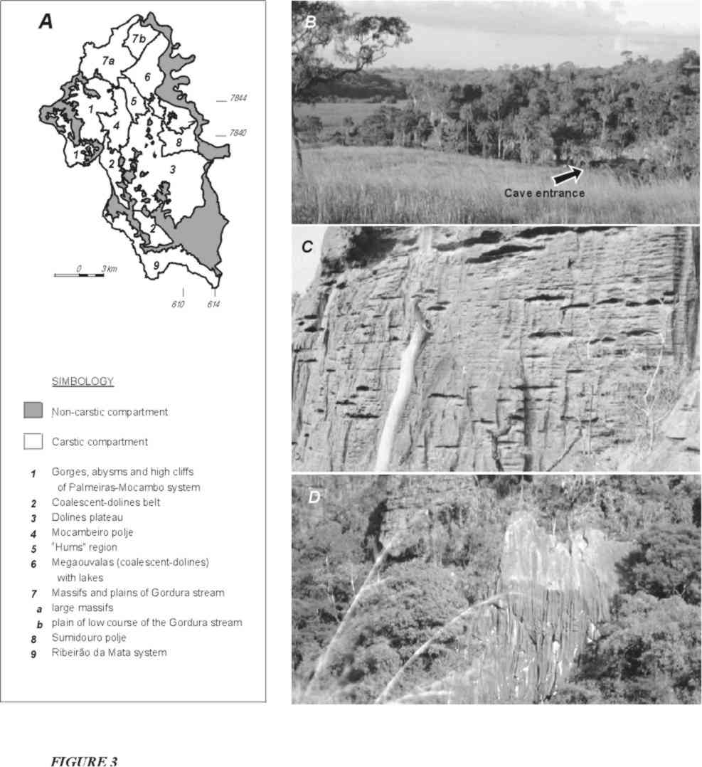
Figure 3: Characteristics of the Lagoa
Santa exokarst. A) Geomorfological compartimentation of the APA area (Kohler et al.,
1998); B) Jaguara massif region; C) Joint karren (schichtenkarren) and D) vertical notches
(rinnenkarren).
Covered
Karstic Surface
Are areas with a thick soil mantle
over the limestones, that limitates very much the expression of the karstic forms. Such
covers occur mainly at the occidental and meriodional portions of the area. The Phyllitic Surfaces cover large extensions
where carbonates underlie metapellitic rocks. In this domain there are sugestive
occurrences of karstic features which can derive from deep karstification of the
carbonates.
Mocambeiro Depression
It corresponds to
a large lowered plain with altitudes around 700 meters, boundered by hills with abrupt
slopes and big rock outcrops. It is placed on an argillaceous mantle which covers the
siliceous carbonates of the basis of the carbonatic sequence, according to drill holes
made in the area (Campos, 1994). It is also described as a polje.
It represents the more dissecated
region of the karst, with periodic flooding following large and gentle dolines. It functions as the local hydric base-level
where the discharge of another great part of the waters collected and drained in the
Karstic Plateau areas is directed to. In some places there are residual rocky massifs with
small associated caves and shelters, classified as “hums”.
Epikarst
In the Lagoa
Santa Karst it is possible to recognize an irregular rocky relief underlying a soil cover
that delineates the general geometry of the high and medium-high slopes of the surficial
relief. According to Piló (1998), the epikarstic relief is marked by two expressive
features: i) the major ruin-shaped of towers
and ii) covered karst karren types. Parcial
outcrop of the residual features in the slopes profile conforming the so-called
“warts” can also be found.
Piló believes that the dissolution
must be quite accelerated in this interface rock/soil, where there is an important action
of the enlarged fractures in the diffuse hydric recharge that happens in the establishment
of a labyrinthitic pattern of the endokarstic forms (conduits) and in the dynamics of its feeling by
sediments.
Endokarst
The caves –
and their chemical and clastic deposits – are the most important representatives of
the Lagoa Santa endokarst, together with the “fissures” or small channels that
also make part of the endokarstic net, fundamental in the water dynamics and as habitat of
a special fauna.
Inside the limits of the APA area
there are 387 caves registered, reaching 500 if the adjoining around is considered, the
Sete Lagoas municipality included. Considering the existence of meaningful non-prospected
areas, those numbers serve to give an idea of the potenciality for new discoverings.
No other locality presents such
density of caverns, which turns it a true “espeleological park”. The diversity
of situations, morphologies and combinations offer a complete and complex figure of the
karstic nature in small spaces of area.
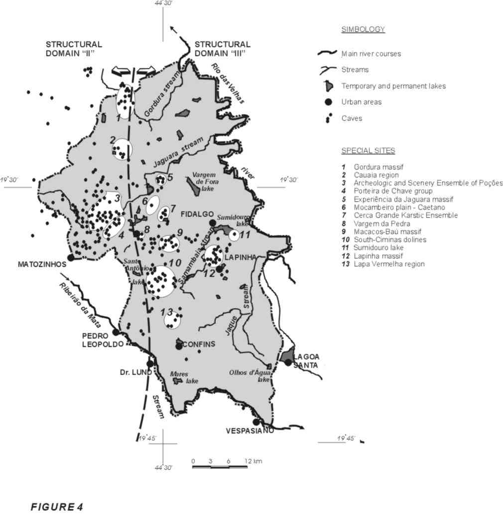
Figure 4: Localization of the caves and of the main ensemble of
karstic features of the Lagoa Santa Karst.
General characteristics of the caves
The regional speleological context shows a predominance of
small caves mostly less 500 meters of extension. Caves
over 800 meters long stands out in the whole, as Baú, Boi, Irmãos Piriá, Rei do Mato
(touristic), Buraco do Medo, Cerca Grande, Lemniskos, Morro Redondo and Cascata II caves. The biggest registered
occurrences are the Gruta da Escada, with 1822 meters long, and Lapa Vermelha I, with 1870
meters long. Morro Redondo presents the biggest total difference in levels, about 75
meters, with a 52 meters span that ties two levels morphologically distincts of the
cavern. The Tobogã, Salitre, Morena and Lapa Nova de Maquiné caves, situated few
kilometers to the North of APA, are also regionally important, the last one being
specially relevant by historical and touristic aspects.
A great variety of speleothem types occur in the diversity of small cave
environments of the region. The caverns with larger profusion of speleothems are those already open to the tourists: Maquiné,
Rei do Mato and Lapinha. Rei do Mato keeps extraordinary specimens of columns and
stalagmites (figure 5A and B), beautiful calcite flowstones and expressive aggregate of
stalactites. Calcite flowstones and curtains are the great attractions in Lapinha (figure
5C).
Ensembles of stalactites, stalagmites, columns, calcite flowstones and
travertine dams of small to medium size (centimetric to decimetric) are common in the
other caverns, as well as coraloids forms (like “cauliflowers”), which cover
large extensions of the enclosing rocks. Are also common calcite crystals called
“tooth-of-dog” and helictites. The travertine dams are shallow in general and
occupy large areas along the low-angle slopes. Travertine microdams are a common variety,
texturing other speleotems surfaces (figure
5D). Deep travertine basins are unusual and are found in the Baú, Escada and Poções
caves. Also unusual are the big stalactites over 4 meters long such as those present in
Lapa Vermelha I and in Paredão da Fenda III. There are isolated occurrences of cave
pearls, volcanos, aragonite curtains, gypsite leaves and needles ( figure 5E), calcite
flowers, triangles and circles.
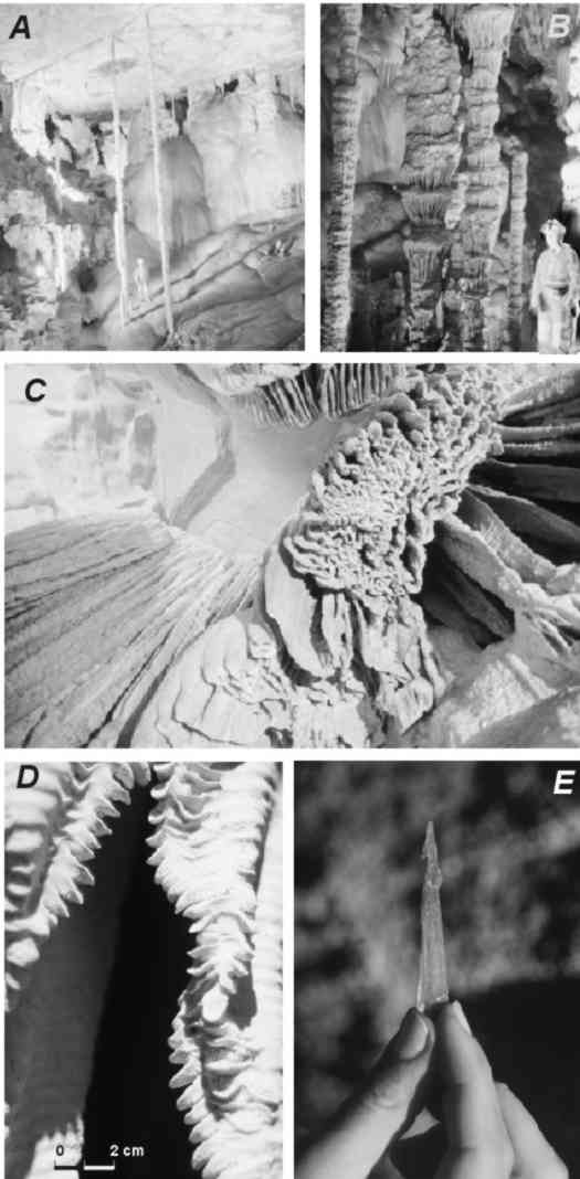
Figure 5: Aspects of Lagoa Santa
endokarst - speleothems: A) Speleothems in the main chamber of the Rei do Mato touristic
cave; B) Stalagmites and columns in Rei do Mato cave; C) Details of curtain in Lapinha
cave; D) Travertine microdams in the curtains surface; F) Gypsite needle in the Intoxicado
cave.
At the surface the caverns appear in
several different situations, associated to many types of dolines, scarps and rocky
massifs. There are some aglomerations that, together with the surficial forms, vegetation
and water bodies, complete special landscapes, some of wich increased by historical and
cultural meaning. This happens with the Cerca Grande Karstic Ensemble, Poções
Archeological and Scenery Ensemble, Cauaia and Gordura massifs, Porteira de Chave
ensemble, Lapinha massif, Mocambeiro and its residual massifs plain, Sumidouro lake, Lapa
Vermelha region, Experiência da Jaguara ensemble, Macacos-Baú massif and dolines on South of Ciminas quarry. The first two
areas are specially protected units.
Geological
conditioning
A first
distinction of shape, arrengement, distribution and frequency of the channels and caverns
is made by the faciologic differenciation (lithologic and tectonic) of the carbonatic
sequence where the karstic relief emerge.
Most of the caverns develop in the homogeneous calcarenites of the
Lagoa Santa Member, where is the typical surficial karstic relief and the main underground
hydrological systems. Statistically, there is preference of conduits belonging to
different hierarchies for certain directions coincident with definide families of
fractures. The underground galleries are bigger and more frequent in the N75-85E and near
N-S directions (figure 6A) (Berbert-Born et al., 1998). It is expected that the nearly E-W
fractures be structures really more apt for an initial enlargement, once they must
represent the main group in the region, arising out of extension tectonic processes (Beato
et al., 1992). The preferential development of the conduits in the N-S direction is
concordant with local patterns of dolines alingnment that, according to Piló (1998), can
reflect the influence of the subhorizontal foliation sofly dipping to the East.
The verticalized geometry of most of
the transversal sections of the galleries (figure 6B) is an expected feature by the
influence of the subvertical atitudes of the fractures. Cases in which the channels appear
in a perfect labyrinthitic net coincident with the articulation of the fracture groups are
very common, such as the Escada, Cerca Grande and Lapa Vermelha caves. In other situations
in non-reticulated galleries, rectilinear portions or even sinuosities clearly imposed by
that type of structure are recognized. So the sections with horizontal tendency are
restrict to situations in which the foliation or lamination is locally more expressive or
in calcitic concentrated levels (remobilized veins).
The impure calcisiltites of the basal sequence (Pedro Leopoldo Member),
with frequent pellitic intercalations, are composicionally less favorable to
karstification. The cavernning occurs in special situations, along the inferior and
superior interformational contacts where deformation is intensified. At the inferior
contact it is related to the lesses permeability of the crystalline bedrock, which forces a longer time of the water residence
and its circulation in the overlied limestone. The best example of this is the Irmãos
Piriá cave. The incision tends to be lateral with progressive widening, characterized by
the displacement of the thin tabular blocks, induced by the strong ondulated foliation and
by their own argillaceous intercalations.
Where the deformation is stronger and more generalized, the
mineral-stretch lineation observed in the planes of the aproximately E-W subhorizontal
lamination has a significative control in the openning of small channels, reenterings and
circular or oval roles. The Gruta da Lapinha keeps characteristic examples of that, just
as illustrated by figure 6C (Berbert-Born et al., 1998).
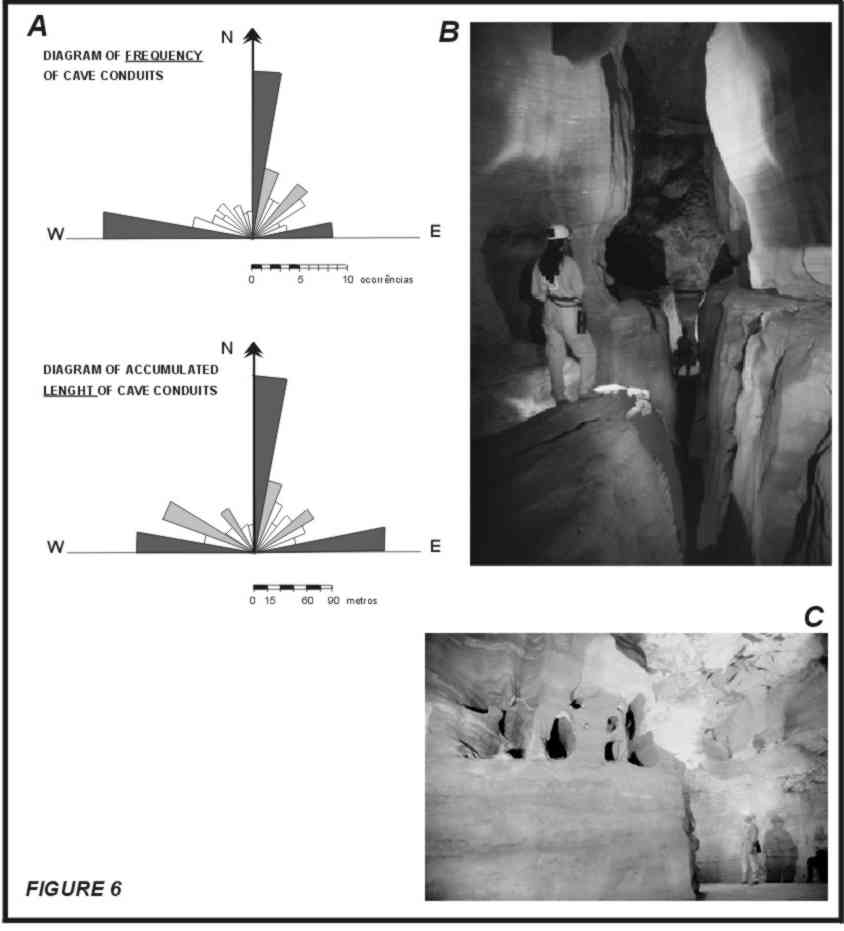
Figure 6
Hydrological condiotioning
Nevertheless the
bigger generic characterization of the caverns in terms of their lithostratigraphic and
structural configuration, there still is a great morphological diversity resulting from
the local hydrological variants.
The Karstic Plateau is a region of great hydric dynamics of capture and
transmission of the pluvial waters towards the local base-levels. In some fluoviokarstic
segments of the area there are caverns typically configurated by the rapid and turbulent
flux of the underground rivers, showing sinuosity character with rectilinear portions, and
galleries vinculated to different tributary hierarchies that are active drainage for a
short cut of time usually. So, there are caverns which configure small portions of a
drainage net, with actually “disconected” segments in consequence of relief
dissecation. The main occurrences are in the Poções region.
But most part of the caverns in this physiographic domain is associated
to the dolines, speacially those bounded by the limestone scarp. Their opennings can be at
the base of the cliffs, at the present bottom of the dolines or above it. They function as
present or past points of capture (sinkholes) of the basins drainage or they are
associated to active and non-active basin floodings.
There are several examples of presently dried caverns situated above
the bottom of the dolines, showing lateral
opennings at “half-high” of the
scarps, such as in the Escada cave. In these cases, it is common the development of little
extensive and irregular caverns at the foot of the cliffs in the bottom of the doline,
functioning as present capture of the waters drained in the basin. One may note examples
that register the progressive evolution of one type to another.
Some of these caverns in the bottom
of dolines correspond to later conections of
the relief with a subterranean system previously conformed. In other words, they are
subsidence dolines evolved from an installed
underground net. In general, this type of situation occurs according doline groups in mutual proximity, characterizing
multiple points of surficial capture, someway conected in the subterranean.
According to Auler (1994, 1995), lakes in dolines are determinative for labyrinthitic (reticular)
planimetries of caves, with a anastomosed tendency, in dependence of the local limestone
structuring. However, the caverns associated to this type of condition show a complex
morfology resulting from the polycyclic hydrologic variations, marked by superimposed
features.
There are good records of different superimposed evolutive phases in
the Baú, Escada and Lapa Vermelha caves, among them, conditions of water level
fluctuation, different phases of sedimentary filling intercalated to the prevailing
chemical precipitation, traces of paragenetic processes, vadose re-incision by drainnings
from the slopes of dolines. As for the
incidence of combinations of different genetic agents it can also be cited the Lavoura,
Morro Redondo and Poções caves (Berbert-Born et al., 1998).
Figure 7: Detailled features of the
Lagoa Santa Karst. A) Laterally disposed windows at half-high of the Cerca Grande rocky
massif, each one conducting to underground galleries mutally parallels, and panoramic view
of the massif; B) Lapa Vermelha entrance in summer, with persons as scale at the center
and base of the opening, and detail ot the entrance in winter.
Other types of
caverns are the exclusive result of the more chemically aggressive, although still
dispersive, of the intersticial waters that percolate the rock discontinuities in a
descendent slow flux. They are little sized in general, sinuous to rectilineous, without
great intercommunications but with big density of occurrence. They commonly are in the
high massifs such as the Poções and Lapinha, although such processes also compound the
evolution of the other cavities. Furthermore, the action of these waters can get to
surprinsing magnitudes when remodelling completely the profiles of the galleries walls,
besides being the principal agent in the elaboration of the secondary chemical
precipitateds (speleothems).
In the Depressão de Mocameiro unit
(Mocambeiro plain), the more significative caverns generaly occur at the base of the rocks
residual to denudation boundered by the outcropping phreatic water. In face of the low
hydraulic gradient, labyrinthitic galleries are articulated with sections of
horizontalized profile due to the expression of the solubilizying processes along the
water surface. They are caverns in complete present conformation, as the caves at the base
of the Jaguara massif. In the massifs and “hums”
there also exist caverns located in a certain high above the present outcropping water
level, some of those materializing past water levels.
Sediments
Different phases
of sedimentary deposition are registered in many caverns in the region. One remarkable
aspect is the association among clastic sequences and levels of chemical precipitation.
The sediments are mainly made up of breccias with argillaceous components, sands, pebbles,
rock fragments and speleothems in very variable
proportions which offer vestiges about the deposicional energies.
Piló (1998) identified three
distinct sedimentary deposits under stalagmitic covers in Baú cave, with rests of extinct
fauna. Over each one erosive process have incided, that determine a great remobilization
and leaching of materials, under vadose regime. U/Th age determinations on the stalagmitic
concretions samples indicate active deposicional cicles between 135 and 60 thousand years
ago. For the chemical depositions , conditions of more humid climates were interpreted.
Evolutive considerations
The evolutive
model of the Macacos-Baú depression proposed by Piló (op. cit.) expresses the main
stages of the dynamics of the regional geomorphology development.
Comparing the estimated local rates of the deeping velocity of the
dolines (altimetric relation between the
stalagmitic covers U/Th age determined and the present bottom of the dolines) and the
total difference in levels of 210 meters between the Sul-Americana residual plateau and
the lowest point in the studied region, it was possible to estimate in 1.9 M.a. as the
maximum age for the beggining of the incision of
that surface, although the dolines have an accelerated dynamics of evolution in the
general context of the landscape formation.
The model defends the configuration
of an underground drainage before the constitution of the karstic relief, evolving to a
relief of closed depressions (the beginning of the dolines formation) with the gradative
encrease of the conections of the endokarstic systems (Low Quaternary). Many caverns that
outcrop today should be related to these primary systems under phreatic regime.
The conformation of the sinkholes has permitted the flux of
a great volume of detritus as debris flows and hydrous fluxes, marking a period of a very
active morfogenesis, probably related to episodes of intense rains under a sparse
vegetation cover. Expressive volumes of channels were generally filled, and that could be
induced, in posterior cicle or cicles, “sectorized” paragenetic development of
galleries. A long period of greater stability and reduction of the clastic flux followed
that phase, and this has permited a chemical sedimentation over the clastic sediments,
what can be related with the expressive climatic change, with the local base-level deeping
or with the impediment of the hydric circulation due to the sediments fill. Later, there was erosion of the deposits
atributed to another period of intense rains. All this phase of clastic filling, followed
by checmical precipitation and a posterior process of erosion is dated older than 135
years ago, based on a stalactite developed under one of the stalagmitic concretion which
overlies an important clastic deposit. Other less energetically intense clastic and
chemical depositional period happened, associated to events of vadose incision of the
galleries and sediments previously deposited (at least three episodes of chemical
sedimentation have been identified). In the sediments underlied stalagmitic concretions
aging near 70 thousand years, vestiges of a extinct megafauna are present.
The increasing of the endokarstic conections, induced even by the
epikarstic evolution, must have facilitated the transportation of the covering materials,
justifying the conformation of the secondary dolines
superimposed to the profile of greater slopes, during the terminal Pleistocene,
according a new period of higher humidity, recorded by pollens and age determinations of the lake
sediments.
Holocenic processes would be expressed by the enlargement of the
dolines, covering depressing, introduction of
more material in the endokarst, block falls in the limestone cliffs and generation of new
stalagmitic covers even over pre-historic human vestiges.
PALEONTOLOGY AND ARCHAEOLOGY
Since Lund, a
great number of informations have been generated in the fields of paleontology and
archaeology, the bigger interest being on the “Lagoa Santa Man” and the
populations that succeded him. Many of the paleontological founds resulted from the
archaeological researches (Cartelle et al., 1998).
There still is an enormous
potentiality for systematic paleontological researches, considering the great number of
small caves almost unknown and their deposicional characteristics. Among the
paleontological material already revealed stand out the components of the extinct
Pleistocenic fauna, such as the giant sloths, “tooth-saber” tiger (figure 8),
lhamas, horses, giant armadillos and mastodons. Nowadays,
the paleontological studies are resctricted to the researches of the Catholic University
of Minas Gerais and Museum of Natural History of the Federal University of Minas Gerais.
The Lagoa Santa archaeology has it importance not only for its role in
the history of that science in Brazil, but also for its antropo-biological revelations,
for the environmental changes vestiges in the Holocene period, for the records of the man
fixation in the area and his surviving, as well as for the traces of pre-historic
technology (lythic , bone, shells, wood and ceramics industries),
according to Prous et al. (1998). Studies already completed made possible to define a
general overview of the regional human occupations and their limitations. Besides that
they have permitted the visualization of the symbolic world of men in pre-history,
specially the funerary rituals and the “rupestrian arts”.
The existence of many sites with “parietal grafisms” elevates
the Lagoa Santa region to the status of one
among the most important “rupestrian provinces” in Brazil. Special important are
the informations about the cronology of the paintings and the recognizing of several
stilistic units. For the first time in Brazil, rupestrian paintings had a
“semi-absolute” age (minimum age) determination when paintings were discovered
below levels of occupation dated by radiocarbon method. The first drafts aged early as 6
000 years.
The oldest known vestiges are “bones dated by coals aging between
10.200 and 11.680 years”, age also confirmed in a recent determination on humic acids
after-death penetrated in a person’s bone (Proust et al., 1998).
Around a hundred of pre-historic sites, among rock shelters and
open-sky sites are recorded by the Archaeological Sector ot the Federal University of
Minas Gerais. Besides the number of sites, it surprises the quantity of existing material,
among which around 80 individuals have been discovered during only one of the researches
done in the region (Prous et al., op.cit.).
Note that some portions of the area, particularly the North and
Northeastern ones are almost unexplored by archaeologists, so being promising for the
discovering of new “key-sites” for science.
The archaeological and paleontological material is groupped in
scientific and didatic collections of well known institutions, and also in private
collections. A lot of material was taken outside Brazil by Lund. Stands out the
collections of the Kopenhagen Museum of Zoology (Denmark), the Museum of Man in Paris, the
National Museum (Rio de Janeiro), the Museum of Natural History of the Federal University
of Minas Gerais (Belo Horizonte), the Museum of Mineralogy of the Federal University of
Ouro Preto, the Center of Archaeology Annette Laming-Emperaire (Lagoa Santa), the
Technological Researchs Center of Minas Gerais State (CETEC/MG). As private collection may
be cited the Archaeological Museum of Lapinha.
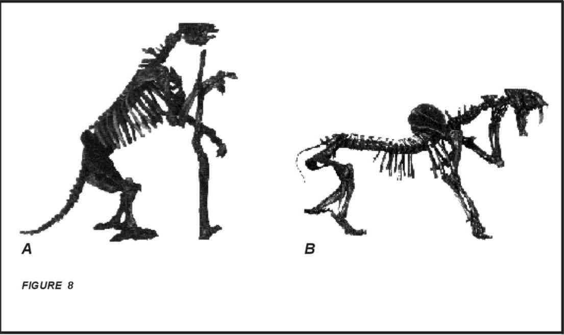
Figure 8: Two fossils collected by
Peter Lund in Lagoa Santa (in Cartelle et al., 1998): A) Complete skeleton of a giant
sloth (6 meters long); B) Complete skeleton of a “saber-tooth” tiger (2 meters
long).
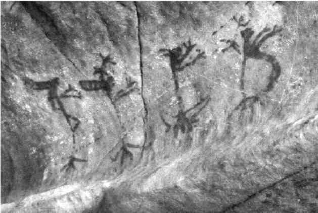
Figure 9: Rupestrian paintings in Lapa
do Ballet: anthropomophs.
CONSERVATION
STATUS
Most of the
caverns have suffered or are suffering direct or indirect interferences of anthropic
activities. The more common and notable are the ones of aesthetic order such as:
speleothems breakage, scribblings and rubbish
accumulations. However, there are other serious damage to the caverns, although less
evident to the common observer. They result from the slow transformations or come from
less perceptive components, but no less importants, such as the fauna, the sedimentary
deposits, the water activity. The impregnation of the surfaces by grime from fires or
other corrosive substances, the algae growing induced by artificial lightening, the
covering of areas by mobilized sediments, flooding, drying, alterations on water
physicochemical and biological composition and modifications on the natural drainage that
alter the cicle of activity of the speleothems, the natural evolution of the forms and the
development of the fauna.
Mining activity is responsible for many of these impacts, since it
removes vegetation and soil, inducing the detritus arrival and modifying the conditions of
the water flux. The transit of the machinery, the explosions and the chimneys emissions
which generate several types of dust and the detonations shock are possible impactant
agents. In this case the damages have a punctual character, but drastic. There are
isolated cases of harmonious coexistence between this type of activity and the
speleological sites, cases of irrecoverable damages and cases of imminent riscks.
Because it is more extensive,
agricultural is perhap the greatest impactant agent, facilitating the soil removal and
nutrients carrying out to the caverns. Besides that deforesting exposes the caverns
openings, modifying the internal atmosferic conditions and attracting a large number of
people. Without the natural protection of vegetation, the frequent pre-historic paintings
and other archaeologic vestiges become more subjected to the weathering action.
The generalized broken of walls and floor concretions of the caverns is
very common, resulting from exploitation of the calcitic concretions mainly in the
proximities of the openings, as well the “residue” of the excavations in search
of archaeological pieces and pre-historic bones. There also was the time when saltpeter
was exploited as gun-powder raw material. The historical and cultural significance
comprises successifull and not so successifull scientific explorations, some of them
definitly harmful because of the absence of appropriate methods employed.
In conclusion, the speleological patrimony ís high vulnerable to
destruction for its localization in a populous and industrial area, and is moderatly
damaged already wtih some critical cases. The
intense depredation arised out of the visits themselves points to the necessity of a
project of environmental education to the local inhabitants. The more viable and efficient
way of conservation is the fiscalization by the own inhabitants, once they are conscious
of the value of the natural patrimony where they live. It is also wholesome the
maintenance of the native vegetation at the proximities of the caverns openings or, in
other words, close to the massifs, rocky cliffs and dolines, what means the conservation
of the external landscape proper (Berbert-Born et al., 1998).
TOURISTIC
POTENTIALITY
The reduced size
of the caverns is a factor restrictive itself to the touristic visitation, since the
natural environment is not capable of holding a great number of persons without strong
interferences, being frequent the situations of discomfort and risk. On the other hand,
the dense agglomeration of the caves is a very interesting aspect with touristic appeal.
The “conventional”
touristic utilization as such happens in Maquiné, Rei do Mato and Lapinha caves, to where
the visitor goes with the intention of admiring speleothems and large chambers, seems to
be exhausted. Viable alternatives turn to be those related to the “speleological
routes” with educational purposes towards the illustration of the karst dynamics, the
biota and the human occupation.
Such way of visitation does not require great adaptations to what is
offered by the environment itself, but little improvement in the access perhaps. The
natural imposition is the visitation by small groups of people accompanied by trained and
instrumented guides in ccompatible number, what means the necessity of low investments.
The routes, on their turn, must have technical approvement after rigorous avaliation of
the points to be visited, being necessary to observe the susceptibilities of what is going
to be opened to visitation, the fauna and the risk factors to the visitors. This
evaluation must indicate the ideal number of persons and the periodicity of visitation,
the necessary procedures and the restrictions (Berbert-Born et al., 1998).
In synthesis, any iniciative in this way
requires a management plan.
COLLABORATORS
Critical reading, suggestions and backing of Dr. Luís Beethoven Piló was crucial for
this paper elaboration, as well as the bibliographic material conceded by Dr. Heinz
Charles Kohler. An profound acknowledgment to these both researchers. And also to Carlos
Oití Berbert, always an fundamental person.
REFERENCES
ALKMIM, F.F., BRITO NEVES, B.B.,
ALVES, J.A.C. 1993. Arcabouço tectônico do Cráton do São Francisco - uma revisão. In:
Dominguez, J.M.L. & Misi, A. (ed.) 1993. O Cráton do São Francisco. Reunião
Preparatória para o II Simpósio Sobre o Cráton do São Francisco. SBG/SGM/CNPq.
Salvador. p.45-62
ALMEIDA, F.F.M. e HASUI, Y.
(org.). 1984. O Pré-Cambriano do Brasil. São Paulo, Edgard Blücher Ed.
AULER,
A.S. 1994. Hydrogeological and hydrochemical characterization of the Matozinhos-Pedro
Leopoldo Karst, Brazil. Western Kentucky, 110p. (Master of Science, Faculty of the
Department of Geography and Geology).
AULER,
A.S. 1995. Lakes as a speleogenetic agent in the Karst of Lagoa Santa, Brazil. Cave and
Karst Science, 21(3):105-110.
BEATO, D., BERBERT, M.L.C,
DANDERFER, A. e PESSOA, P.F.P. 1992. Avaliação preliminar do Carste de Sete Lagoas-Lagoa
Santa e riscos ao meio ambiente antrópico - Projeto VIDA. In: SIMPÓSIO DA SITUAÇÃO
AMBIENTAL E QUALIDADE DE VIDA NA REGIÃO METROPOLITANA DE BELO HORIZONTE E MINAS GERAIS,
2. Belo Horizonte, 1992. Anais... Belo Horizonte:ABGE, p.56-59.
BERBERT-BORN, M., HORTA,
L.S., DUTRA, G.M. 1998. Levantamento Espeleológico. In: APA Carste de Lagoa Santa -
Patrimônio Espeleológico, Histórico e Cultural. Belo Horizonte, CPRM/IBAMA. 71p, anexos
e mapas. (Série APA Carste de Lagoa Santa,
volume III).
CAMPOS, A.B. 1994. Relações
entre as características faciológicas e estruturais das unidades do Grupo Bambuí e a
morfologia cárstica na região de Lagoa Santa-Pedro Leopoldo (Minas Gerais). Belo
Horizonte, UFMG/FAPEMIG, 21p. (Relatório final de pesquisa - aperfeiçoamento. Programa
de Pesquisa “Estudos ambientais e proposta de manejo na região do carste no Planalto
de Lagoa Santa, M.G.”).
CARTELLE, C. ABUHID, V.,
FERREIRA, MA.A., FERREIRA, R.L. 1998. Levantamento paleontológico. In: APA Carste de
Lagoa Santa - Patrimônio Espeleológico, Histórico e Cultural. Belo Horizonte,
CPRM/IBAMA. 9 p., anexos e mapas. (Série APA Carste de Lagoa Santa, volume III)
CETEC-Fundação Centro
Tecnológico de Minas Gerais, 1987. Estudos da dinâmica dos recursos hídricos da região
cárstica dos municípios de Lagoa Santa, Pedro Leopoldo e Matozinhos. Belo Horizonte,
CETEC. 38p. Relatório técnico.
CPRM-Serviço Geológico do
Brasil, 1994. Caracterização geomorfológica da região cárstica de Sete Lagoas-Lagoa
Santa (MG). Belo Horizonte, CPRM/CETEC. 37 p., 1 mapa (6 folhas). (Projeto VIDA VIDA -
Programa Gestão e Administração Territorial).
GOMES, M.C.A., PILÓ, L.B. 1992.
As minas de salitre: a exploração econômica das cavernas em Minas Gerais nos fins do
período colonial. São Paulo, SBE. Espeleo-Tema, 16:83-93.
IBGE, 1993. Mapa de vegetação
do Brasil, escala 1:1500.000.
KOHLER, H.C. 1989. Geomorfologia cárstica na região de Lagoa Santa/MG. São
Paulo. (Tese de Doutorado, Departamento de Geografia da Universidade de São Paulo).
KOHLER, H.C., PARIZZI, M.G.,
SOUZA, J.B., CASTRO, V.H.C. 1998. Mapa Geomorfológico da APA Carste de Lagoa Santa. In:
APA Carste de Lagoa Santa - Meio físico. Belo Horizonte, CPRM/IBAMA. (Série APA Carste
de Lagoa Santa, volume I).
PATRUS, M.L.R.A. 1996. Hidrologia e qualidade de águas de superfície do município
de Sete Lagoas. Belo Horizonte, CPRM. (Projeto VIDA - Programa Gestão e Administração
Territorial). Inédito.
PILÓ, L.B. 1998. Morfologia
cárstica e materiais constituintes: Dinâmica e evolução da Depressão Poligonal
Macacos-Baú - Carste de Lagoa Santa, Minas Gerais. 269p. (Tese de Doutorado, Departamento
de Geografia da Faculdade de Filosofia, Letras e Ciências Humanas da Universidade de São
Paulo).
PROUS, A., FOGAÇA, E., RIBEIRO,
L. 1998. Patrimônio arqueológico. In: APA Carste de Lagoa Santa - Patrimônio
Espeleológico, Histórico e Cultural. Belo Horizonte, CPRM/IBAMA. 22 p., anexos e mapas.
(Série APA Carste de Lagoa Santa, volume III).
SCHÖLL, W.U. 1976. Sedimentologia e geoquímica do Grupo Bambuí na parte sudeste
da Bacia do São Francisco. In: CONGRESSO BRASILEIRO DE GEOLOGIA, 29. Ouro Preto, 1976.
Anais..SBG, 2:207-231.
SOUZA, H.A. (org.) 1998.
Zoneamento ambiental da APA Carste de Lagoa Santa. Belo Horizonte, CPRM/IBAMA. (Série APA
Carste de Lagoa Santa).
TULLER, M.P., RIBEIRO, J.H.,
DANDERFER FILHO, A. 1991. Geologia da região cárstica de Sete Lagoas-Lagoa Santa (MG).
Belo Horizonte, CPRM. (Projeto Vida - Programa Gestão e Administração Territorial). Inédito.
VIANA, H.S., TAVARES, V.P.,
KOHLER, H.C., 1998. Síntese da geologia, recursos minerais e geomorfologia. In: APA
Carste de Lagoa Santa - Meio físico. Belo Horizonte, CPRM/IBAMA. 21 p., anexos e mapas
(Série APA Carste de Lagoa Santa, volume I).