 Ver em portuguęs Ver em portuguęs
SIGEP
Geological and Paleontological Sites of Brazil - 005
THE CRATO MEMBER OF THE SANTANA FORMATION,
CEARÁ STATE
Date:
27/09/1999
Maria Somália Sales Viana
somalia@npd.ufpe.br
Virgínio Henrique Lopes Neumann
neumann@npd.ufpe.br
Universidade Federal de
Pernambuco - Centro de Cięncias e Tecnologia - Departamento de Geologia
Rua Acadęmico Hélio Ramos, s/n, Cidade Universitária - CEP: 50.740-530 Recife-PE
Tel.: (81) 2718240 - FAX: (81) 271 8234
© Viana,M.S.; Neumann,V.H.L. 1999. The Crato member of the Santana formation, Ceará state, Brazil. In: Schobbenhaus,C.; Campos,D.A.; Queiroz,E.T.; Winge,M.; Berbert-Born,M. (Edit.) Sítios Geológicos e Paleontológicos do Brasil. Published on Internet at the address http://www.unb.br/ig/sigep/sitio005/sitio005english.htm
[actually
https://sigep.eco.br/sitio005/sitio005english.htm]
[SEE
PRINTED CHAPTER IN PORTUGUESE]
(The above bibliographic reference of author copy rights is required for any use of this article in any
media, being forbidden this use for any commercial purpose)
|
ABSTRACT
The Crato
Member of the Santana Formation is an important geologic and paleontologic site in Brazil,
located at the interior of Northeastern region. This unit is part of the Sedimentary
Araripe Basin where the main outcrops are in the Northeast flank.
Litologically, it is composed by horizontal calcareous beds, interfingered to
shales, siltstones and sandstones, deposited during the Lower Cretaceous (about 120 m.
y.). These calcareous rocks are exploited by the cement and ornamental rocks industries,
forming an important mining activity in the country. These rocks are also very rich in
fossils, including an abundant and diversified fauna and flora, well preserved. The
entomofauna and the flora represent a significant record to the knowledge of the
angiosperm development.
The mining activities cause partial fossil and local nature fisiography
destruction. An urgent preservation program as the creation of parks and eco-turistic
activities is most necessary.
INTRODUCTION The Crato
Member of the Santana Formation, composed basically of horizontal calcareous beds
(Figure 1)
is a conspicuous paleontologic and geologic site of the Northeast Brazilian region.
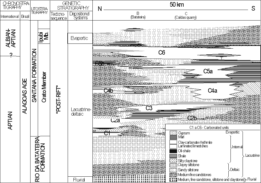
Figure 1 – Simplified stratigraphic scheme for the Aptian-Albian lacustrine system
of the E Araripe Sub-basin.
The deposition of this unit was during the
lower Cretaceous (about 120 m. y.) and the fossils are abundant and diversified. This
includes invertebrates (ostracods, conchostracans, insects, aracnids, bivalves and
gastropods), vertebrates (actinopterygians, coelacants, pterosaurs, quelonids, crocodiles,
lizards, birds and anphibians), plants (algae, gminosperms and angiosperms), ichnofossils
(coprolites, invertebrate tracks and estromatolites) and palinomorphs.
These
fossils are well preserved, normally by piritization, limonitization or carbonization
processes. The most abundant is insect, followed by fishes (mainly Dastilbe) and plants.
The entomofauna and the flora are a significant record to the knowledge of the angiosperm
development.
The Crato Member outcrops follow the contour of the Araripe plateau and are located
in Porteiras, Barbalha, Crato, Nova Olinda and Santana do Cariri villages in Ceará State
(Figures 2 and 3). They can be seen in the river falls or in slight hills below the plateau
scarps.
The climate correspond to Köppen Aw classification, with rains of 700 to 1000
mm.year-1. The annual average temperature is about 27oC.
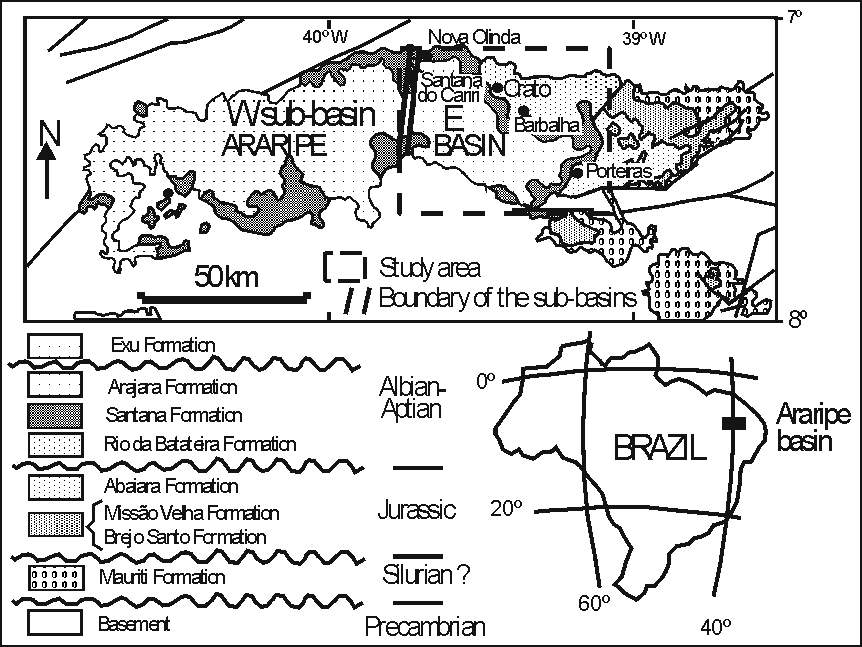
Figure 2 – Location area and geologic map.
Figure 3 – Location map of the main outcrops of the Crato Member (clay-carbonate
rhythmites and laminated limestones) at the E Araripe Sub-basin. The draw was rotationed
to obtain a better view of the site localizations.
HISTORICAL
The
paleontological researches in the Araripe basin began in 1823 when Spix and Martius
arrived in Brazil in a scientific mission. This research trip was organized by the King of
Baviera Maximiliano Jose I, in order to study the South American natural resources. These
researchers registered the first fossiliferous record of the Araripe region, mentioning
the occurrence of fishes in calcareous concretions (Romualdo Member) and in limestones
(Crato Member).
From 1836 to 1840 the Gardner travel made incursions to the site. By this time, the
first studies about the fossil collections of the Brazilian Geological and Mineralogical
Survey were made.
In 1947, R. S. Santos (a brazilian researcher) described the fish Dastilbe
(Figure 4)
of this basin and suggested fresh water as depositional environment to the limestones of
the Crato Member.
From 1963 to 1971 K. Beurlen, professor in the Geology School of Recife –
Pernambuco, carried out studies of the Mesozoic of the Northeast region and, in 1971,
defined the stratigraphical table of the Santana Formation with three members: Crato
(lower), Ipubi (intermediate) and Romualdo (upper). He also suggested the first ecological
relation. Some authors (Beurlen, 1963; Martill, 1993; Neumann & Cabrera, 1999)
suggested to elevate the category of the Crato Member to Formation.
The insects are very diversified and until now there are 200 species described. To
this classification participated A. Costa Lima, I. D. Pinto, I. Purper, R. G. Martins Neto
and D. A. Grimaldi.
In relation to the plants more studies are needed as they are abundant, diversified
(woods, leaves, seeds, flowers and fruits) and well preserved.
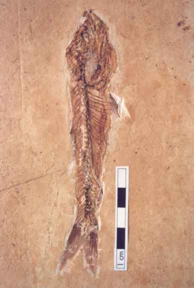
Figure 4 – Dastilbe elongatus
Santos.
LOCALIZATION
The Araripe
Sedimentary Basin is located at the interior of the northeastern Brazil, in the Borborema
Structural Province (Brito Neves, 1990), occupying part of Piauí, Pernambuco and Ceará
States. It is located between 38030’- 45050’W and 7005’
- 7050’S. This basin was divided by Rand & Manso (1984) in two
sub-basins: West (W) and East (E) (Figure 2).
The Crato Member of the Santana Formation outcrops only at the scarps of the E
sub-basin of Araripe. This sub-basin is West limited by the meridian 39045’
(close to Santana do Cariri Town) and at East is limited by the meridian 38030’
(close to Bonito da Santa Fé Town). Its North limit is at the parallel 7005’
(close to Nova Olinda Town) and the South limited at the parallel 7040’(close
to Jati Town), totalizing an area of aproximately 5,500 km2.
SITE DESCRIPTION
The Crato Member of the Santana Formation constitute a lacustrine sequence,
chiefly carbonated, that was originally named of "calcários de Sant’ana"
by Small (1913). The carbonated lacustrine facies associations of this member are mainly
composed by six carbonated units (C1 to C6) (Figure 1). These units are constituted of
micritic laminated limestones and clay-carbonate rhythmites, with colours varying from
light to dark brown and light to dark grey, alternating with shales and fine sandstones.
The clay-carbonate rhythmites are always at the base of the carbonated units and are
recovered by the laminated limestones. Salt pseudomorphs (halita) and various well
preserved fossils: fishes (mainly Dastilbe (Figure 4)), insects and plants, are within the
laminated limestones (Figure 5).
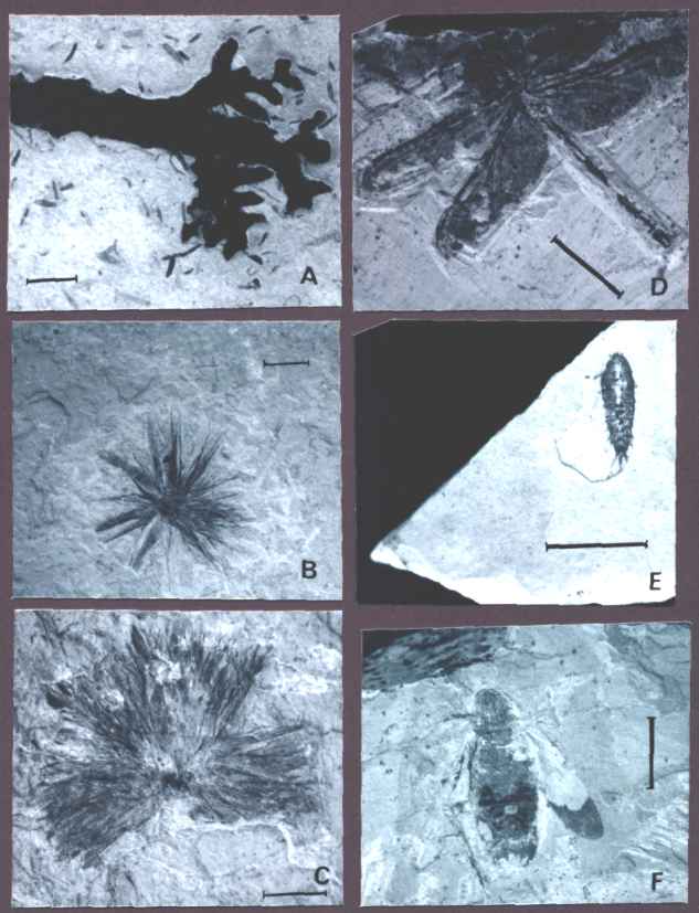
Figure 5 – Plants and insects of the Crato Member of the Santana Formation: A.
Gimnospermae (Brachyphyllum Brongniart); B. Angiospermae (undetermined flower); C.
Angiosperma (undetermined flower); D. Zigoptera; E. Ephemeroptera; F. Blattodea. These
specimens belong to the fossil colection of the Federal University of Pernambuco. The bars
in each foto correspond to 1 cm.
The six carbonated units of the Crato
Member are distributed in various outcrops located at the scarps of the northeastern
flancs of the E tableland, from Santana do Cariri to the proximities of Porteiras Town
(Figures 2 and 3), extending under the tableland.
Most of the laminated limestones
outcrops are recovered by colluvium deposits, eroded from the overlaying sediments (mainly
of the Exu Formation).
Generally, the laminated limestones outcrops are located on quarries or on the
edges of the rivers that cut the scarps.
The main localities in which the limestones are well exposed are: a) The quarries
between Nova Olinda and Santana do Cariri Towns, b) The quarries located on the Batateiras
River edges, at Crato Town, c) Santa Rita and Caldas quarries, near the Barbalha Town, d)
The outcrops on the E scarps of "Serra do Măozinha", and e) The outcrops on the
rivers near Porteiras Town (Figures 2 and 3).
Three of these sites are distinguish by the great exposition area, thickness and
intense exploitation: a) The quarries located between Nova Olinda and Santana do Cariri
Towns, b) The quarries located at the Batateiras River edges and c) Santa Rita and Caldas
quarries, near the Barbalha town (Figure 6).
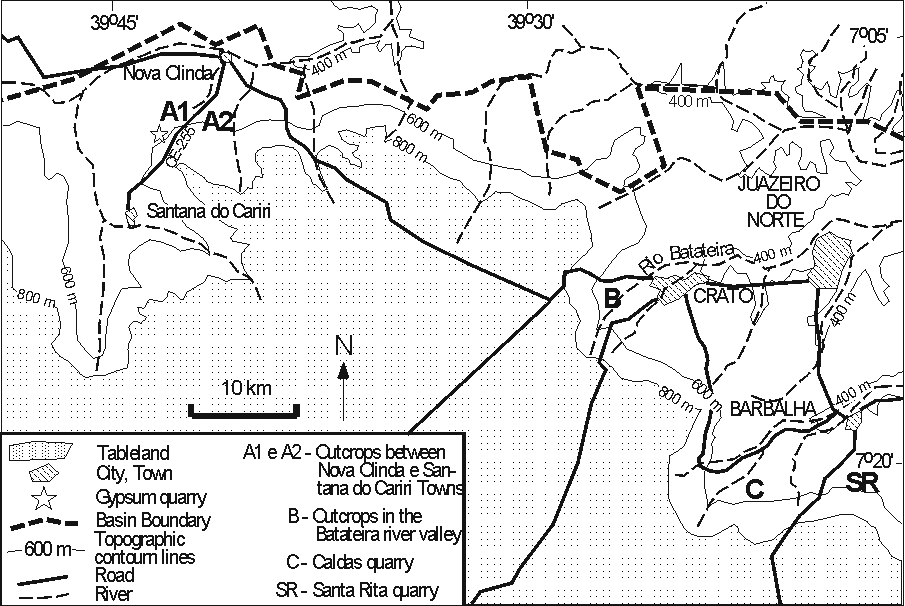
Figure 6 – Detailed map of location of the three main paleontological and
geological sites at the E Araripe Sub-basin.
The outcrops description, in which the
carbonated units are well exposed, are:
a) Quarries between Nova Olinda and Santana do Cariri Towns
The laminated limestones outcrops in both, left and right sides of the quilometer 5-6
of the road (CE-255) that conect the Towns of Nova Olinda and Santana do Cariri
(Figure 7).
The limestones are exploited by craftmen and traded to construct walls, tables, houses,
etc.
In this area the units of laminated limestones are 5-10 m thick, and constitute a
single, tabular body (carbonated unit 6 = C6, see Figure 1), that extend laterally in all
area. This tabular body is limited at the base and at the top by shales.
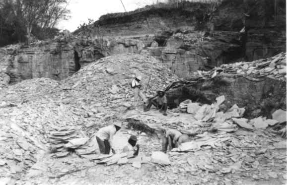
Figure 7 – Craft exploitation of laminated limestones (carbonated unit C6,
Figure 1)
of the Crato Member of the Santana Formation. This outcrop is located in km 4-5 of the
road CE-255, between Nova Olinda and Santana do Cariri Towns. The photo shows the rejected
material, after sorting the best one.
b) Quarries of Batateiras River edges
The quarries are located, mainly, at the right side of the river, at the locality
named "Cachoeira", in Lameiro Square, in Crato Town (Figure 6). The laminated
limestone exploited here belongs to the unit C4 (Figure 1). It is 3-6 m thick, in this area.
c) Santa Rita and Caldas quarries
The Santa Rita and Caldas quarries
(Figure 6) belongs to the IBACIP - Barbalha
industry of cement, which exploit the units C3, C4 and C5 (Figures 1 and 8).
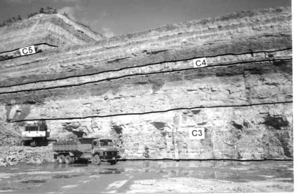
Figure 8 – Photo of Caldas quarry, showing the exploitation front SW-NE. The Crato
Member of the Santana Formation (represented by the cabonated units C3, C4 and C5,
Figure 1)
is exploited by the cement industry.
PRESERVATION PROGRAM
The
Crato Member rocks constitute an important calcareous mine that are exploited by the
cement and ornamental rock industries (Figures 7 and 8). These mining activities have been
responsible by the erosion increase and river packing, causing environmental destruction
(Figure 7).
The fossil trade also contributes to the destruction of the deposits through ilegal
exploitation, that mainly occurs at the ornamental rock mines.
Thus, it is necessary an urgently preservation program of this important site. The
creation of parks, for example, would help to preserve some areas. The Araripe plateau
region is extremely rich in natural beauty regarding the geomorphology, the mineral water
fontains, the vegetation and the nice climate. This region has many activities related to the tourism as the
paleontological museum, commerce of crafts, religious parties, recreation clubs, hotels,
etc. Each aspect contributes to the increase of the regional economy with eco-touristic
activities.
REFERENCES
Beurlen,K. 1963.
Geologia e estratigrafia da chapada do Araripe. In: Congresso Brasileiro de
Geologia,17, Rio de Janeiro, 1963. SBG, Anais: 1-47.
Beurlen, K. 1971. As condiçőes ecológicas e faciológicas da Formaçăo
Santana, na chapada do Araripe (Nordeste do Brasil). Anais da Academia Brasileira
de Cięncias, Rio
de Janeiro, 43 (suplemento): 411-415 .
Martill,D.M. 1993.
Fossil of the Santana and Crato formations, Brazil.
Paleontological Association, Field Guide to Fossils, n. 5, 159 p.
Neumann,V.H.;
Cabrera,L. 1999. Una nueva propuesta estratigráfica para
la tectonosecuencia post-rifte de la cuenca de Araripe, noreste de Brasil. In:
Simpósio Cretáceo Brasileiro, 5, Serra negra, 1999. UNESP, Boletim de
Resumos: 279-285.
Santos,R.S. 1947. Uma redescriçăo de Dastilbe elongatus, com
algumas consideraçőes sobre o gęnero Dastilbe. Rio de Janeiro,
Divisăo de Geologia e Mineralogia, Boletim 42, 7 p.
Small,H. 1913. Geologia e suprimento de água subterrânea no Ceará e
parte do Piauhy. Inspetoria de Obras Contra Secas. 180 p. (Série Geologia, Vol.25)