|
 Ver em português Ver em português
SIGEP
Geological and Paleontological Sites of Brazil
- 001
ARAGUAINHA
DOME
THE LARGEST ASTROBLEME IN SOUTH AMERICA
Date:01/07/1999
Alvaro P. Crósta
Instituto de Geociências – Universidade Estadual de Campinas
Caixa Postal 6152 – 13081-970 Campinas SP
E-mail: alvaro@ige.unicamp.br
© Crosta,A.P. 1999. Araguainha dome - The largest astrobleme in South america. In: Schobbenhaus,C.; Campos,D.A.; Queiroz,E.T.; Winge,M.; Berbert-Born,M. (Edit.) Sítios Geológicos e Paleontológicos do Brasil. Published on Internet at the address
http://www.unb.br/ig/sigep/sitio001/sitio001english.htm
[actually
https://sigep.eco.br/sitio001/sitio001english.htm ]
[SEE
PRINTED CHAPTER IN PORTUGUESE]
(The above bibliographic reference of author copy rights is required for any use of this article in any
media, being forbidden this use for any commercial purpose)
|
ABSTRACT
Domo de Araguainha (Araguainha
Dome) is the largest known astrobleme in South America. It is a 40-km wide
eroded complex crater, formed near to the Permian-Triassic boundary (245 Ma.),
when a celestial body struck what was probably a shallow sea. The rocks affected
by the impact include the Ordovician crystalline basement (granite) exposed at
the center of the 6,5-km wide central uplifted core of the astrobleme and
sedimentary units from the Paleozoic Paraná Basin (Furnas, Ponta Grossa,
Aquidauana and Estrada Nova formations), disposed in rings around the central
uplift. Impact metamorphic features include shatter cones in sandstones from the
Furnas Formation, several types of impact breccias, planar features in quartz,
mica and feldspar from granites and from breccias, severe deformation and
hematite impact bombs.
INTRODUCTION
Collision of celestial bodies is currently considered a
common geologic phenomenon throughout the solar system and recognized as a dominant
process in the early geological history of some planetary bodies, including the Earth
(Grieve, 1987). The most recent impact cratering record of the Earth (Grieve et al., 1995)
lists about 150 impact craters (or astroblemes) and crater fields known on Earth, to which
about 3 to 5 new ones are discovered each year. This author emphasizes that this is just a
small and biased sample of a probably much larger number of craters. The majority of the
known structures are less than 200 Ma, usually located in cratonic areas such as North
America and northern Europe-western Russia, areas that have been specifically searched for
impact structures.
In planetary bodies that lack or have very
thin atmospheres and on those that have retained portions of their earliest crusts, such
as the Moon, impact craters dominate the surface’s morphology, being responsible for
the major topographic and stratigraphic features. Unlike these planetary bodies, the
Earth’s surface shows comparatively few impact craters, due to highly active geologic
environment of the Earth, which has obliterated, masked or modified the terrestrial
cratering record through geologic time.
In South America, there are only eleven known
impact craters. Eight of them are located in Brazil: Domo de Araguainha, Serra da
Cangalha, Riachão, Vargeão, São Miguel do Tapuio, Colônia, Cerro Jarau and Piratininga
(Crósta, 1987; Hachiro et al., 1996). Two other craters are located in Argentina (Campo
del Cielo and Rio Cuarto) and one in Chile (Monturaqui). Of all the impact craters in
South America, Domo de Araguainha (Araguainha Dome) is the largest, possibly the oldest
and the best known.
Araguainha Dome covers an area of
approximately 1,300 km2, with a diameter of 40 km. It was formed over
sedimentary rocks of the Phanerozoic Paraná Basin, an intracratonic basin that covers the
southern portion of Brazil, stretching to Argentina, Paraguay and Uruguay. The first
reference to the existence of a dome-type structure at Araguainha was made by Northfleet
et al. (1969). These authors interpreted the structure as the result of a Cretaceous
syenite intrusion that uplifted and deformed the Phanerozoic sediments in the shape of a
dome.
Due to this proposition, and considering the
economic potential of the alkaline magmatism of the Cretaceous Iporá Formation elsewhere
in Goiás State, Silveira Fº & Ribeiro (1971) carried out a reconnaissance geological
survey. These authors described Araguainha Dome as a crypto-volcanic structure, with the
central portion being formed by a granitic block, belonging to the crystalline basement of
the Paraná Basin. According to these authors, the central portion of the dome was
surrounded by volcanic rocks (lavas, breccia and tuffs) of trachytic composition and by
tectonically deformed Paleozoic sediments
Dietz & French (1973) and Dietz et al.
(1973) proposed a new hypothesis for the formation of Araguainha, relating it to the
impact of a large cosmic body against the Earth's surface. They recognized features due to
shock metamorphism in samples from the center of Araguainha Dome, such as shatter cones
and planar features (shock lamellae) in quartz, with orientations corresponding to {1013},
{1012}, {1122} and {1121} planes, together with the impact breccia around the core of the
structure.
Crósta et al. (1981) and Crósta (1982)
reported on the results of geological mapping, geomorphologic characteristics and
petrographic analysis of samples from the granitic basement, the impact breccias and from
the Furnas Formation, all bearing evidence of shock metamorphism. Their results reinforced
the origin of the structure by impact. Among the evidences recognized by these authors
were shatter cones in sandstones of the Furnas Formation at two localities, shock lamellae
in quartz, mica and feldspar, changes from crystalline to amorphous state in minerals
without melting, with the vitreous phase retaining the morphologic and textural
characteristics of the crystalline phase, and kink bands in minerals. Crósta (1982) also
presented the result of the first isotopic age dating for the shocked granitic basement
exposed at the central uplift of Araguainha, using the K-Ar technique. This author
obtained an age of 283.6± 17.2 Ma for K-feldspar, pointing out that this age should be
interpreted as a mixture of the age of formation of the granite (Pre-Devonian), and not
the actual age of the impact, since the shock stage of the granite sample analyzed
wasn’t advanced enough for a total degassing of pre-existing Ar. The mafic portion of
the same granite sample gave an age of 362.6± 13.2 Ma, also an anomalous young age for
the granitic basement of the Paraná Basin.
Theilen-Willige (1981) pointed out that
geomorphologic, petrographic and geophysical evidence found in the Araguainha Dome
supported the origin of the structure by meteoritic impact. Among the recognized features
there were the circular shape of the structure, the impact-related morphology, including a
central uplift, ring walls and a basin rim of escarpments, evidences of shock
metamorphism, the presence of suevite and impact breccias, shatter cones and negative
magnetic anomalies at the center of the structure.
Deutsch et al. (1992), based on isotopic
dating of two samples from Araguainha, estimated an upper limit for the age of the impact
as 243± 19 Ma, based on a Rb-Sr model age for alteration products of cordierite from a
sample of the impact melt (fine-grained crystalline matrix with quartz, albite, minor
K-feldspar, biotite, titano-magnetite, ilmenite, hematite and barite). For a sample of a
partially shocked granite from the central uplift, these authors obtained a Rb-Sr isochron
with an age of 449± 9 Ma. Their results placed the impact event near the Permian-Triassic
boundary.
Engelhardt et al. (1992) presented a detailed
petrographic and geochemical study of the interior part of the 6.5 to 8 km-wide central
uplift of the Araguainha Dome, focusing on the shocked granite and the breccias. They
presented a geologic map of the inner part of the central uplift, showing the distribution
of three types of breccias: impact breccia with melt matrix, polymict impact breccia and
monomict impact breccia from sandstones. They also found 10-100 cm thick and tens of
meters long red dykes cutting the granite, formed bycataclastic mixtures of unshocked,
shocked and shock-melted granitic materials, which were intruded into the granite under
conditions of extensional stress, probably during the uplift of the granitic bottom of the
transient crater during the modification phase of the impact. These authors also
determined the age of the impact event by 40Ar/39Ar dating of impact
melt samples from the lower unit of polymict breccias, which showed ages of 247± 5.5 and
245.8± 5.5 Ma for two different grain size fractions of the same sample. These ages
confirm that the impact event occurred close to the Permian-Triassic boundary.
Hammerschmidt & Engelhardt (1995) presented
the results of a second 40Ar/39Ar dating of impact and also of the
granitic basement. Two size fractions of the impact melt rocks provided plateau ages of
245.5± 3.5 Ma and 243.3± 3.0 Ma, respectively, confirming that the Araguainha impact
event occurred close to the Permian-Triassic boundary. Total degassing ages of biotites of
the granite from the central uplift produced values ranging from 326 to 481 Ma, with this
variation being explained by the authors as due to Ar losses. They interpreted the oldest
age obtained for the biotite as the evidence that the ascending granite passed the 300o
C isotherm earlier than 481 Ma. (Pre-Devonian).
Masero et al. (1994) and Fischer
& Masero
(1994) conducted a magnetotelluric survey across Araguainha astrobleme, in order to
determine the depth of the crystalline basement under the structure and also to estimate
the uplift of its central region. They found that the basement forms a well defined
symmetric ring at a depth of 1,000 meters between the radii of 9 and 20 km from the
center, dropping further away outside 20 km. Inside the ring and toward the center, the
top of the granite rises, outcropping at 1.5 to 2 km from the center. Masero et al.
(1997), through 2-D and 3-D modelling of magnetotelluric data, found a disk-shaped body
within the granite at depths of 3 to 7 km, characterized by resistivity values below the
bulk value of the upper crust. These authors relate the anomaly to impact-induced faulting
and brecciation of the crust.
Hippert & Lana (1998) studied impact bombs
that occur in association with the polymict breccias in the central uplift of Araguainha
Dome. The bombs contain shocked quartz particles captured during cooling and show
enrichment in platinum-group elements (Rh-4x, Pd-5x, Pt-30x) relative to the target rocks.
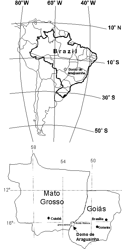
LOCATION
The center of the Araguainha Dome is located at the
coordinates 16º47´S and 52º59´W, in between the villages of Araguainha and Ponte
Branca, in Mato Grosso State (Figure 1). The Araguaia River cuts across the middle of the
structure, which is located partly in Mato Grosso State and partly in Goiás State.
Araguainha Dome can be easily reached by car,
from Goiânia or from Cuiabá, by the BR-364 interstate. The village of Ponte Branca,
located on the NE border of the structure, is 100 km from the interstate, accessible by an
unpaved road which goes to Barra do Garças (MT). Another unpaved road (MT-306) links
Ponte Branca to Araguainha, cutting across the central uplift which lies in between these
two villages, closer to Araguainha (Figure 4). Some of the best outcrops of the geological
units of the central uplift (shocked sandstones and granite, breccias and shatter cones)
can be found along road MT-306, or not far from it.
Figura
1 – Localização do Domo de Araguainha
DESCRIPTION
OF THE SITEMorphology
Araguainha Dome forms a remarkable
ring-shaped structure, consisting of an uplifted core (the central uplift), annular
ridges, ring depressions and valleys, arcs of isolated hills and terraced walls. Figure 2
shows a Landsat MSS band 7 image, depicting the annular aspect and general overview of the
astrobleme.
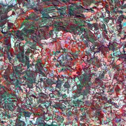
Figure 2. Araguainha
Dome (States of Mato Grosso and Goiás) in a colour composition (channels
4, 5 e 3 - infrared and false colour) of Landsat satelite (Thematic Mapper)
. The image covers an area of 40 x 40 km.
A
small elliptical basin forms the core of the central uplift, corresponding to the area of
the granitic basement. An inner ring of hills, formed mostly by shocked granite and
overlying breccias (Figure 5), surrounds the basin, drained by the Seco Creek. This ring
is in turn surrounded by another ring of ridges and mountains, 6.5-8 kilometers in
diameter, formed by folded and steeply inclined Devonian sandstones of the Furnas
Formation (Figure 3). In the northern part of the central uplift, blocks of the Furnas
sandstone, locally shock-metamorphosed into quartzites, can reach up to 150 meters in
height.
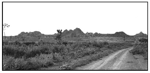
Figure 3.
External view of the central uplift showing its morphology. Folded and steeply inclined
sandstones of the Devonian Furnas Formation form the hills, reaching up to 150 meters in
height.
The
central elevation is surrounded by a ring depression, with a slightly undulated floor and
a few isolated hills, corresponding to the areas of exposure of the Devonian Ponta Grossa
and the Carboniferous Aquidauana formations. According to the description given by
Theillen-Willige (1981), the most conspicuous aspect of the Araguainha structure is the
existence of concentric multiple rings of ridges, hills, depression belts and valleys. The
annular ridges have been dissected by drainage systems. Crósta (1982) showed that these
morphologic features are controlled by annular and radial fault systems, typical of impact
craters. This ring depression is cut by the Araguaia River.
The external border of Araguainha Dome is formed by rim
crests, representing the remnants of semi-circular grabens formed by annular collapse
faults dipping towards the center of the structure. These grabens contain highly deformed
Permo-Carboniferous sediments of the Passa Dois Group/Estrada Nova Formation. Generally
speaking, Araguainha Dome is a deeply eroded complex impact crater, or an astrobleme. The
depth of the excavation was estimated by Engelhardt et al. (1992) as 2,400 meters, which
is one-tenth of the diameter of the transient crater (24 kilometers), formed just after
the impact. This represents 0.6 of the diameter of the final crater (40 km).
Geology
The geological map of Figure 4 shows the distribution of
the main geological units that occur in the area of the Araguainha Dome. The geology of
the central uplift is presented in more detail in Figure 5. The description presented next
is mostly based on the work by Crósta et al. (1981) and Engelhardt et al.
(1992), and will concentrate on the shock metamorphic features. These features occur at
the central uplift, involving lithologies from the granitic basement and the Furnas
formation, besides the breccias formed by the impact.
GRANITIC BASEMENT
The outcrops in the inner portion of the
uplift are composed of alkali-feldspar granite. Although some of the original
characteristics of the rock may still be seen, all the outcrops exhibit impact-induced
features at some stage. The texture of the granite varies from hypidiomorphic to
porphyritic, with predominance of porphyritic granites with K-feldspar phenocrysts up to 5
cm in size. The main constituents are quartz, K-feldspar, albite, biotite and muscovite,
with the following accessories: zircon, tourmaline and calcite.
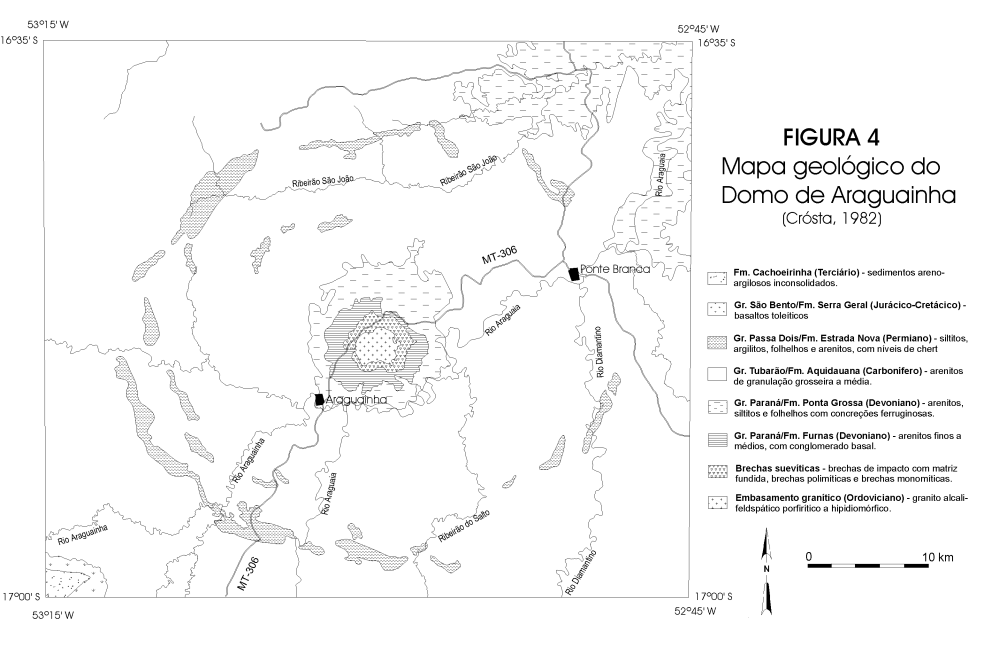
Figure 4 - Geologic Map of Domo de Araguainha - Brazil
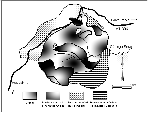
Figure 5.
Geologic map of the inner portion of the central uplift (after Engelhardt et al., 1992)
These rocks, together with
the breccias, exhibit the majority of impact-induced deformation at Araguainha.
The most common deformation is the development of planar deformation structures
("shock lamellae") in quartz (Figure 6a). Up to four different sets of
planar features were observed by Engelhardt et al. (1992) in a single quartz
grain from the granite. Crósta (1992) also observed shock lamellae in feldspar
and muscovite (Figure 6b). The presence of {1012} planar feature in quartz
indicates that the granite now exposed in the central uplift of Araguainha was
shocked at peak pressures in between 20 and 25 GPa.
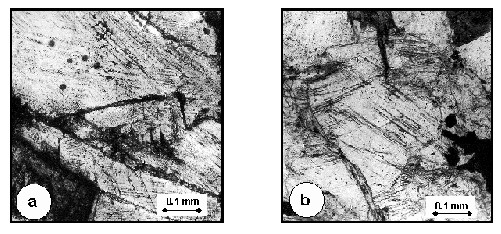
Figure 6.
Planar deformation features (shock lamellae) in quartz (a) and muscovite (b), from the
shocked granite. Two sets of deformation features can be seen in each mineral.
Engelhardt
et al. (1992) described the occurrence of 10-100 cm thick dikes of red color and breccia
veins of gray color cutting the granite. The dykes are composed of angular mineral
fragments showing a fluidal texture. Quartz fragments within the dykes show planar
deformation features or are re-crystallized to a mosaic of interlocking crystals.
Indications of incipient melting are seen on quartz and feldspar grains and glass is quite
common in these dikes. The breccia veins reach up to few centimeters in thickness,
composed of angular clasts of granites and granite minerals. Both, the dikes and veins are
interpreted by the authors as mixtures of unshocked, shocked and shocked-melted granitic
materials, which were intruded into the granite under conditions of extensional stress.
Several deformation features were described in the granite by Crósta et al (1981) and
Engelhardt et al. (1992), including plastic and brittle deformations of mineral grains
(intragranular deformation) and movement of individual grains against each other
(intergranular deformation). Features such as undulatory extinction in K-feldspar, kink
bands in micas and plagioclase, disintegration of quartz grains along stress fractures,
selective transformation of minerals (mainly feldspar) into an amorphous phase (glass)
without melting, general oxidation of iron-bearing minerals (biotites), among others.
IMPACT BRECCIAS
Impact breccias occur in the central uplift
of Araguainha, around and covering the granitic basement (Figure 4). At least three
different types of breccias were described by Crósta (1982) and later mapped and
characterized by Engelhardt et al. (1992): impact breccia with melt matrix (IBM), polymict
breccia and monomict breccia from sandstones.
IBM typically overlies the granite, appearing
macroscopically as light to dark gray coloured rock with lighter inclusions of feldspar
and quartz grains of irregular to rectangular shape, exhibiting fluidal textures (Figure
7a). Chemical analysis showed that IBM and granite are identical in main components and in
trace elements.
Polymict breccias mostly surround the granite
in the north and northwest. These are well exposed in cuts along the road from Araguainha
to Ponte Branca, forming as an unsorted and unstratified mass of constituents of various
shapes, ranging from irregular masses and angular fragments (Figure 7b). These fragments
are several meters to centimeters in size, together with bodies embedded in a fine-grained
groundmass. The fluidal texture indicates turbulent movements and flow and the
distorted/twisted shape of some components show that they were plastically deformed.
Monomict impact breccias from sandstones were
found in the hills bordering the central basin in the south and southeast. Their area of
occurrence is poor in outcrops and covered by cerrado-type vegetation and the few samples
described by Engelhardt et al. (1992) consist of thermally altered and fused quartz
sandstones with angular grains.
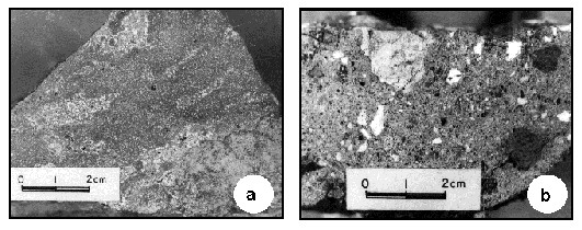
Figure 7. Macroscopic
aspects of impact breccias. (a) Impact breccia with melt matrix; (b)
Polymict breccia with angular fragments of granite, sandstone and other
components.
SHATTER CONES
Shatter cones, as well as planar features (shock lamellae)
in quartz, are among the most well established evidences of meteoritic impact events, as
they were only recognized in association with impact craters worldwide. The occurrence of
shatter cones at Araguainha Dome was first mentioned by Dietz et al. (1973) and further
detailed by Crósta et al. (1981) and Theilen-Willige (1981).
Shatter cones were found in sandstones of the
Devonian Furnas Formation that surround the granitic core and the breccias, in the western
and northwestern portions of the central uplift. They form aggregates of conic structures
(Figure 8), each cone reaching up to 10 cm in size. The gray sandstones show shock-induced
quartz and mica recrystallization and cataclasis. Shatter cones were also found by
Engelhardt et al. (1992) in sandstone fragments within the impact breccias.
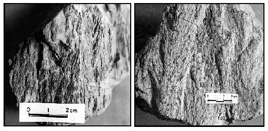
Figure 8.
Shatter cones in sandstone of the Devonian Furnas Formation
HEMATITE BOMBS Hematite aggregates were described in association with
impact breccias at Araguainha by Crósta et al. (1981). Optical and scanning electron
microscope (SEM) analysis of these aggregates by Hippert and Lana (1998) showed that these
aggregates are impact bombs. They show an asymmetrical external geometry, with convex and
concave sides, which also corresponds to their internal structure, comprising porous
hematite in the convex side and massive hematite in the concave side (Figure 9a). Both,
porous and massive domains are composed of an aggregate of individual units with a conical
geometry and showing a feather-like morphology when viewed across longitudinal sections
(Figure 9b). According to the authors, these microstructures reflect a well-ventilated
cooling process during their ballistic trajectory. Quartz fragments with planar
deformation features occur in the porous domains, representing ejected solid particles
captured by the bombs during cooling. Hippert and Lana (1998) also conducted a neutron
activation analysis of the hematite bombs for platinum-group elements. They found
enrichments such as Rh (4x); Ru, Ir and Pd (5x); and Pt (30x) relative to the normal level
of target sediments, relating these enrichments to the presence of a projectile-derived
component in the constitution of the hematite bombs.
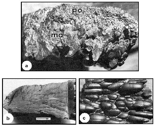
Figure 9.
Hematite bombs. (a) Transition between massive (ma) and porous (po) hematite associated
with the front and the rear of the bombs, respectively. Feather-like structures (F)
appears in the massive domain; (b) Transversal section, showing a detail of the
feather-like structures. The arrow indicates the atmospheric ablation during the ballistic
trajectory of the bomb; (c) morphology of the rear portion of the bomb (from Hippert and
Lana, 1998)
PROTECTION MEASURES Araguainha Dome is a well-preserved example of a complex
astrobleme, with plenty of classical macroscopic and microscopic evidences of shock
metamorphism. As such, it is unique in Brazil and South America and extremely valuable as
a permanent study site for impact events. Due to the age of the impact event, close to the
Permian-Triassic boundary, a period in which one of the most important mass extinction
events in the history of the Earth occurred, this site may be of key importance for the
study of the Earth’s cratering record in relation to mass extinction events.
As with most sites of geological interest,
the population that lives nearby is not aware of the origin and history of the Araguainha
Dome and the reason why it is of unique scientific and cultural interest. The first step
towards conservation of this site is therefore to let the local population be aware of its
value and how to better preserve it. This could be achieved through an education program
focusing on school children and also adults living in the villages of Araguainha and Ponte
Branca.
The great majority of outcrops that show
evidence of shock metamorphism are located along the road MT-306, or very close to it.
These outcrops need to be preserved, since most of them show medium to severe weathering
effects, making the rocks quite fragile. This is the case particularly of the shatter
cones in Furnas sandstones and impact breccias. Maintenance works have already damaged
several well-exposed examples of the impact breccias in road cuts, first seen by this
author in 1979.
A program directed towards the preservation
of the outcrops in the region of the central uplift of Araguainha Dome, combined with
awareness programs for the local population, are therefore strongly recommended as
protection measures of this valuable site.
REFERENCES
Crósta, A. P. 1982. Mapeamento geológico do
Domo de Araguainha utilizando técnicas de sensoriamento remoto. Instituto Nacional de
Pesquisas Espaciais (INPE), São José dos Campos. Dissertação de Mestrado 90 p.
Crósta, A. P. 1987. Impact structures in Brazil.
In: J. Pohl (ed.) Research in Terrestrial Impact Structures. Wiesbaden, Vieweg
& Sohn, 30-38.
Crósta, A. P., Gaspar; J. C.; Candia, M. A. F
1981. Feições de metamorfismo de impacto no Domo de Araguainha. Revista Brasileira de
Geociências, 11: 139-146.
Deutsch, A.; Buhl, D.; Langenhorst, F. 1992. On
the significance of crater ages: new ages for Dellen (Sweden) and Araguainha (Brazil). Tectonophysics,
216:205-218.
Dietz, R. S.; French, B. M. 1973. Two probable
astroblemes in Brazil. Nature, 244:561-562.
Dietz, R. S.; French, B. M.; Oliveira, M. A. M.
1973. Araguainha Dome (Goiás) and Serra da Cangalha (Mato Grosso): probable astroblemes?
In: SBG, Congresso Brasileiro de Geologia, 27, Resumo das Comunicações, 1:102.
Engelhardt, W. v.; Matthäi, S. K.; Walzebuck, J.
1992. Araguainha impact crater, Brazil. 1. The interior part of the uplift. Meteoritics,
27:442-457.
Fischer, G.; Masero, W. 1994. Rotational
properties of the magnetotelluric impendance tensor – the example of the Araguainha
impact crater, Brazil. Geophysical Journal International, 119:548-560.
Grieve, R. A. F. 1987 Terrestrial impact
structures. Episodes, 10:86.
Grieve, R. A. F.; Rupert, J.; Smith, J.;
Therriault, A. 1995. The record of terrestrial impact cratering. GSA Today, 5:189-196.
Hachiro, J.; Coutinho, J. M. V.; Coimbra, A. M.;
Fernandes, L. A. 1996. Fossil tracks of a falling star in the Cretaceous of the Paraná
Basin (Brazil). Anais da Academia Brasileira de Ciências, Resumo das
Comunicações, 68:618-619.
Hammerschimidt, K.; Engelhardt, W. 1995. 40Ar/39Ar
dating of the Araguainha impact structure, Mato Grosso, Brazil. Meteoritics, 30:227-233.
Hippert, J.; Lana, C. 1998. Aerial
crystallization of hematite in impact bombs from the Araguainha astrobleme, Mato Grosso,
central Brazil. Meteoritics & Planetary Science, 33:1303-1309.
Masero, W.; Schenegg, P. A.; Fontes, S. L. 1994.
A magnetotelluric investigation of the Araguainha impact structure in Mato Grosso-Goiás,
central Brazil. Geophysical Journal International, 116:366-376.
Masero, W.; Fischer, G.; Schnegg, P. A. 1997.
Electrical condutivity and crustal deformation from magnetotelluric results in the region
of the Araguainha impact, Brazil. Physics of the Earth and Planetary Interiors. 101:271-289.
Northfleet, A. A.; Medeiros, R.A.; Muhlmann, H.
1969. Reavaliação dos dados geológicos da Bacia do Paraná. Boletim Técnico da
Petrobrás, 12:291-346.
Silveira Filho, N. C.; Ribeiro, C. L. 1971.
Informações geológicas preliminares sobre a estrutura vulcânica de Araguainha, Mato
Grosso. DNPM/Distrito Centro-Leste (relatório interno).
Theilen-Willige,
B. 1981. The Araguainha impact structure, Central Brazil. Revista Brasileira de Geociências, 11:91-97.