
SIGEP
Geological
and Paleontological Sites of Brazil - 096
CHAPADA DOS VEADEIROS
NATIONAL
PARK, GOIÁS STATE, BRAZIL
Date: 31/07/2000
Marcel Auguste
Dardenne
dardenne@tba.com.br
José Eloi
Guimarăes Campos
eloi@unb.br
Universidade
de Brasília -Instituto de Geocięncias
Departamento de Geoquímica e Recursos Minerais
Caixa Posta 04465 - CEP 70910-970 Brasília DF
© Dardenne,M.A.; Campos,J.E.G. 2000. Chapada dos Veadeiros National Park, Goiás state, Brazil. In: Schobbenhaus,C.; Campos,D.A.; Queiroz,E.T.; Winge,M.; Berbert-Born,M. (Edit.) Sítios Geológicos e Paleontológicos do Brasil.
Published
31/7/2000 on Internet at the address http://www.unb.br/ig/sigep/sitio096/sitio096english.htm [Actually
https://sigep.eco.br/sitio096/sitio096english.htm] [SEE
PRINTED CHAPTER IN PORTUGUESE] (The above bibliographic reference of author copy rights is required for any use of this article in any media, being forbidden the use for any commercial purpose) |
ABSTRACT
The present paper intend to show the main geological and
geomorphological sites preserved in the Chapada dos Veadeiros National Park and
neighbourhod. Among the sites of geologic interrest the lithologic, sedimentological and
structural aspects are evidenced, while the most important geomorphological features are
associated to the highlands, ridges and hills of great natural beauty. The publication of
these data set is important because the region shows ample touristic potential, and the
sites preservation is associated to the knowledge of their importance, fragility or
rarity. In general the tourists do not have any information about the origin, importance
or particularity of the places and structures visited, what brings risks to the
preservation of the natural sites found in the region.
INTRODUCTION
The Chapada dos Veadeiros National Park (CVNP) is one important area of
environmental preservation that includes on its limits many natural monuments and sites
with particular interest on geological and geomorphological features. In the park there
are many areas that because of their natural beauty must be considered geological sites of
Brazil. Despite being a permanent preservation area these sites are still exposed to
risks, however the protection and publication of this information is of great importance.
This paper is the summary of the geologic mapping (1:100.000 scale)
carried out at the region of the park and neighbourhood (Dardenne et al. 1998 and
Martins 1999). The geologic map was elaborated by the integration of field data, satellite
image (1:100.000 scale) and aerial photographs (1:60.000).
LOCALIZATION
The National Park of the Chapada dos Veadeiros is located in the
northern segment of Goiás State in central Brazil, with an area of 60 square kilometers,
in the follow coordinates: 13o 51´ and 14o 10´ south latitude and
47o 25´and 47o 42´ west longitude (figures 1 and 2). The access
from Brasilia, is by the BR-020 until reach the GO-118 State road, from where turns
towards north and get the Săo Gabriel and Săo Joăo D´Aliança villages after what
reaches to the de Alto Paraíso town. The east limit of the park is around the GO-118
State road (between Alto Paraíso and Teresina de Goiás towns) and the south limit
follows the State road that links Alto Paraíso de Goiás to Colinas do Sul.
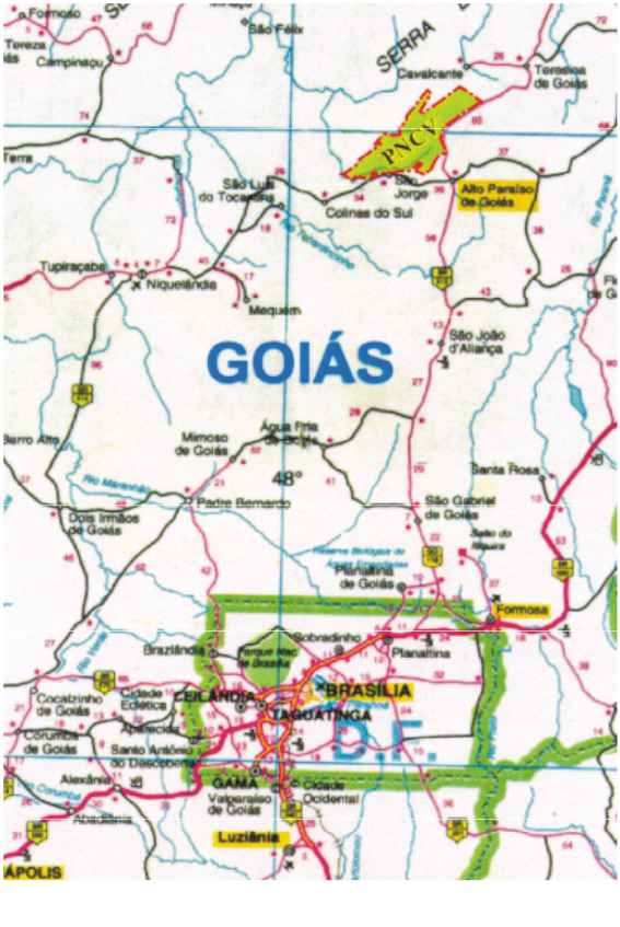
Figure 1 – Location and access map of the Chapada dos
Veadeiros National Park.
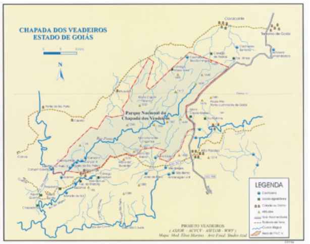
Figure 2 – Distribution of the main attractions and
important points with geological sites (sedimentary structures and geomorfological
aspects).
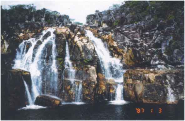
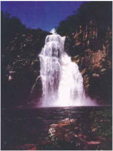
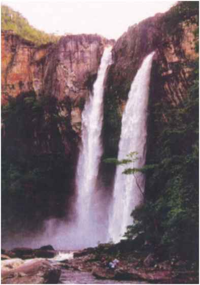
Among the main tourism attractive (park and neighbourhood) the 120
meters, the 80 meters, the Săo Domingos, the Cordovil, the Raizama and the Carioquinhas
waterfalls, the region of the Canyons, Carrossel, Vale da Lua and many trails and
beautiful landscapes are the points most appreciated by the visitants (photographs from 1
to 8).
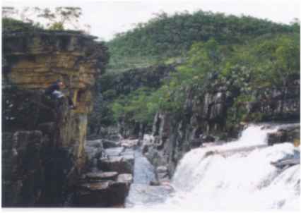
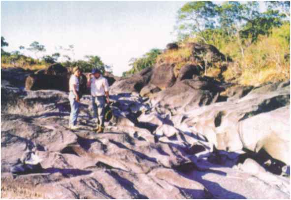
Photographs 1 and 2 – General view of I and II Canyons
(Preto River).
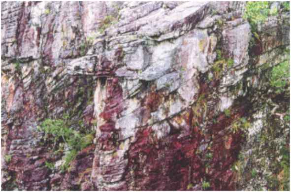
The Rio Preto region called the I and II Canyons is basically
represented by the Q2 Unit. These rock types are characteristically
composed by medium to coarse quartzite associated to fine conglomerates lenses, generally
present at the top of the quartzite banks. Intercalated beyond the two canyons, there is a
metric level (2,5 to 3,0 meters) of a grey metasiltstone rich in non-orientated cyanite
crystals. Along the two margins of the river it can observed many sedimentary structures
that indicate depositional conditions related to high tidal energy environment. Among the
structures the parallel bedding, cross stratification, herringbone and asymmetric ripple
marks are the most common. The lithology show general attitude N60-70E dipping 25o
towards SE. The features called I and II canyons represent the channeling of the water
flux in great open vertical fractures, respectively in the N30W e N60E directions.
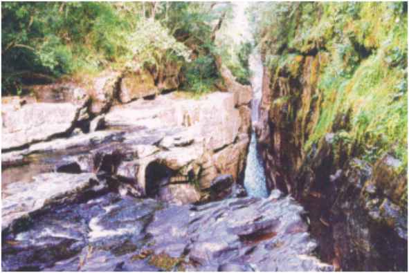
Photography 3 – Partial view of the Carioquinhas Water Fall
(Preto River).
This locality represents a little water fall about 12 meters preserved
in the Q2 Unit quartzite. In this place the cross stratification
indicating opposite paleo currents directions are quit common, what show tidal
depositional conditions. There is also observed along the river margin scarps many sandy
sigmoid bodies associated to tidal environment. The quartzite are medium to coarse but
rarely show conglometaic lenses. In the area many, fracturing directions are observed, the
N60W pattern is associated to the waterfall and the N30W and N45E are also observed.
Photography 4 – Overturned cross bedding of the Pedreira
region.
The Pedreira region is represented by a great sequence of
quartzite outcrops along the river margins and fast stream. In this place the medium to
coarse quartzite show many different cross stratification (overturned, tabular and
herringbone). All types of cross stratification indicate high energy in a context of tidal
reworking environment. Especially the overturned types show the reworking of previously
deposited sandy layers.
The geomorphology observed in this area is associated to an intense
fracturing pattern, where quartzite blocks in the boundary of fracture planes make easy
the preservation of the structures due to the silicification of the rock.
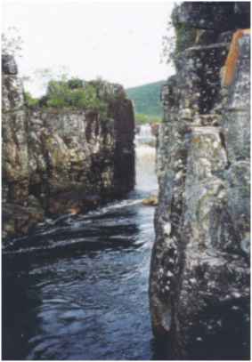
Photography 5 – General view of the 80 meters Waterfall
(Preto River).
Waterfall located next to the geological contact between the Q2
quartzite Unit and the MS2 metasiltstone Unit. In the sandy and pelitic
intercalation observed next to the base of the waterfall there are many quick sand
structures. The waterfall is related to a N60E fracture plane.
Photography 6 – General view of the 120 meters Waterfall
(Preto River).
Waterfall supported by carbonate bearing metasiltstone, where there are
fine to medium quartzite intercalation in the upper portion. The bedding and the
horizontal lamination are the sedimentary structures observed in the quartzite, and in the
metasiltstone there are a pervasive slate cleavage.
The geologic context indicates the external portion of the marine shelf
with pelitic deposition by suspensive processes. The quartzite intercalation indicates the
sandy entrance as the result of fast sea level variation or as a result of storm events in
the internal shelf portion.
Photography 7 – General aspect of Vale da Lua site (Săo
Miguel River).
It corresponds to a sequence of fast stream and boreholes present along
the Săo Miguel River. This visiting point is not in the CVNP boundary, and is located
about 5 km southwest the Săo Jorge Village. The area is composed by diamictites showing a
greenish grey pelitic matrix and immersed clasts, belonging to the basal unit of the
Paranoá Group. The great boreholes observed are produced by the dissolution of the
carbonate material present in the matrix and in the clasts of the diamictite. The
sedimentation of this unit is related to alluvial fans in arid climate, and deposition is
associated to debris flow processes.
Photography 8 – General view of the Salto do Raizama (point
of convergence of the Raizama Stream and the Săo Miguel River).
It corresponds to a waterfall, also located out of the boundary of the
park. The waterfall is supported by metasiltstone correlated to the upper unit of the
Araí Group. Next to this area there are diamictites associated to the Săo Miguel Unit.
SITES DESCRIPTION
Regional Geological Context
The region of the CVNP is associated to the northern portion of
Brasilia Thrust and Fold Belt in the Tocantins Structural Province. In the park, the
metasediments of the Araí Group cover the major area. Towards north there are the gneiss
and the granitic rocks that configure the regional basement. Towards south, there is the
discordant contact of the Paranoá Group rocks. In this sense there will be described the
Paleoproterozoic gneiss-granitic complex, the Paleo-Mesoproterozoic Araí Group and the
Meso-Neoproterozoic Paranoá Group.
The gneiss-granitic Complex represents the regional basement, is well
distributed towards north of the park and comprises the low lands of the Rio Claro valley.
This gneiss and granitic rock complex is constituted by tonalitic and granodioritic
orthogneiss associated to great batholiths of granitic composition, commonly represented
by biotite granite. In general the foliation is marked by mafic and felsic banding and
shear bands with milonitic and cataclastic foliation in ruptile and ruptile-ductile zones.
The majority of age determinations by K/Ar radiometric methods provide
ages varying from 500 to 2500 Ma. (Hasui & Almeida, 1970; Cordani & Hasui, 1975
and Hasui et al., 1975). However, Rb/Sr isocrons and U/Pb dating in the
supracrustal rocks allow the interpretation of Paleoproterozoic ages to these rocks
(Pimentel et al., 1991). The youngest rocks are related to metamorphic events
during the following orogenetic cycles.
All along the basement belt there are granitic batholiths intrusions
associated to the Parană Tin Sub-Province. U/Pb dating indicates Paleo-Mesoproterozoic
ages (ca 1770 Ma.; Pimentel et al., 1991) to these rocks. The batholiths are
represented by biotite granite, chemically compatible to anorogenic granites (type A
granites).
The Araí Group corresponds to low grade greenschist metamorphic
sediments, deposited in continental, transitional and marine environments associated to
the evolution of a Paleo-Mesoproterozoic rift. This unit was initially described by
Barbosa et al. (1969) and Dyer (1970), and has been divided into the Arraias and
Traíras formations. The Arraias Formation represents the sandy-conglomerate basal
succession with 1000 meters thickness, that recovers in discordance the gneiss and
granitic basement. The Traíras Formation is constituted by a sandy-pelitic sequence with
little carbonate contribution in the upper portion of the succession, that reaches 1200
meters in total thickness. Araújo & Alves (1979) in detailed geological mapping
considered a total thickness of 1140 meters to all the Araí Group and divided it in six
units, where the 1 to 3 units correspond to the Arraias Formation and the units 4 to 6 are
related to the Traíras Formation.
Marini et al. (1984) consider important lateral variations in
the thickness and compositions of each facies due to the distance of the source areas of
the sediments.
The Araí Group presents a structural polarity, where the most intense
deformation (isoclinal folds) is in the internal portion of the Brasilia Belt. Towardss
the cratonic area open folds represent the deformation. Locally the structural features
are complicated by the lineaments that represent important transcurrent zones, resulting
in stratigraphic problems with the elimination or thickening of units.
The Araí Basin origin is related to the evolution of a north-south
trend continental rift, which was evolved by reactivation of weakness zones present in the
gneiss-granitic basement. The U/Pb ages obtained from zircons of the acid volcanic rocks
from the base of the Araí Group show that the rift evolved in limit of the Paleo to the
Mesoproterozoic (1770 Ma., Pimentel et al., 1991).
Covering the Araí Group in erosive discordance, the Paranoá Group
which is present southwards the CVNP is a psamo-pelitic-carbonated sequence. This unit can
be followed towards south along the Serra Geral do Parană Ridge in the Alto Paraíso,
Săo Joăo D’Aliança, Săo Gabriel e Distrito Federal regions (Faria, 1995). Faria
(1995) purposed an integrated stratigraphy that can be correlated regionally in the
external portion of the Brasilia Belt. The units are called from code-letters, from the
base to the upper: SM, R1, Q1, R2,
Q2, S, A, R3, Q3, R4,
PC. The main characteristic of the units distributed to the south of the CVNP,
including some of the geological sites considered here, are described:
- SM Unit (locally called the Săo Miguel conglomerate):
represented by a diamictite with siltstone, quartz, quartzite and marble clasts, immerse
in a siltic- argillaceous-carbonatic matrix. The massive aspect of the rock makes
difficult to observe the form and composition of the clasts. This unit can be followed for
great distances even though it is not a continuum layer.
- R1 Unit: shows a concordant contact with the basal
conglomerate and is constituted by a succession of intercalation of siltstones, pelitic
bearing carbonates and fine to coarse feldspatic quartzite. Dissecation cracks and salt
cube pseudomorphs are often observed in the base of the sequence. Towards the top of the
sequence undulated quartzite and argillaceous metasiltstone intercalations are
predominant.
- Q1 Unit: is represented by fine to medium, white,
well stratified banks (30 to 40 cm) quartzite and occasionally intercalation of
argillaceous siltstone. Cross stratification is quite common in the top of the layer.
- R2 Unit: shows an abrupt contact with the Q1
quartzite, and is characterized by fine pink quartzite banks intercalated with siltstone
and white pelitic levels. Cross laminations cut by waves, ripple marks, quick sand,
fluidization structures and dissecation cracks are commonly observed.
- Q2 Unit: constituted by centimetric to metric,
white to yellow, medium quartzite, commonly fine, with rounded clasts and feldspatic rich
conglomerate filling channels. Many types of cross stratification are common.
The depositional systems associated to the Paranoá Group are related
to shallow marine conditions, and the variation in sand and pelitic proportions attributed
to the variations of the water deepness due to transgressive and regressive events.
The metamorphism related to the Paranoá Group can be determinate by
the phengite and chlorite paragenesis and is characteristic of very low grade (low
greenschist facies). Just in the internal zone of the Brasilia Belt (e.g. Niquelândia or
Minaçu) the rocks may be associated to the biotite zone of the greenschist metamorphic
facies. In the great majority of the occurrence areas the sedimentary structures are well
preserved.
Stratigraphy and Depositional Systems of the CVNP
The stratigraphy of the Araí Group was made up in the occidental
portion of the park (Rio Preto Ridge) where the sedimentary layers are just few affected
by the folding associated to the transcurrent zones. This stratigraphy is representative
of the major area of the CVNP, excepting the north portion associated to the Santana
Ridge, where a different succession can be observed. In both cases, the Araí Group lies
over the granitic basement.
RIO PRETO RIDGE
The Rio Preto Ridge occupies the main area of the CVNP and
presents a WSW-ENE trend. These quartzite and metasiltstone are divided in six main units.
Basal Quartzite: Q1
The basal quartzite Q1 overlies in discordance the
basement granites. Two main facies Q1f and Q1P were established.
The Q1f facies is distributed towardss the westhern portion
of the Rio Preto Ridge, and outcrops as one straight south to the Gaviăo Farm. It is
constituted by coarse quartzite, and lithic/arkosean metaconglomerates of fluviatile
origin with cut and fill channels and cross stratification. The thickness of this facies
is about 50 meters.
The Q1P facies occurs preferentially at the base of the Rio
Preto Ridge scarp, as laminated quartzite with low angle cross stratification, probably
associated to a beach transitional environment.
Inferior Metasiltstone: MS1
The MS1 Unit overlies the basal Q1 quartzite.
This unit is distributed in the occidental portion of the Rio Preto Ridge, and is
represented by a thick horizon of grey, laminated calciferous metasiltstone, locally
undulated. They show quartzite intercalation that may reach 20 meters thickness. Locally,
pink to red carbonate boxwork can be observed. A cleavage dipping southward is commonly
developed. The sedimentation is represented by agradation process in low energy marine
conditions. The thickness is variable, and the great values are measured in the region of
the Rio Preto waterfalls, where values of 100 meters can be observed. Laterally towards
northeast the metasiltstones reach thickness of 30 to 50 meters.
Intermediate Quartzite: Q2
The intermediate quartzite Q2 overlies the MS1
metasiltstone and is the most representative and well-distributed unit of the park in the
NE-SW direction. The quartzite marks the scarp of the north front that limits the low
lands of the basement (Rio Claro Valley) and the central portion of the CVNP. This unit is
characterized by a thick medium to coarse quartzite sequence with tabular, channeled
inverse and herringbone cross stratification that is typical of a tidal environment
(photography 9). The thickness of the intermediate quartzite can locally reach 200 meters.
Some horizons of laminated metasiltstone are found intercalating the quartzite and the
thickness of these pelitic rocks vary from 5 to 30 meters. The great diversity of the
sedimentary structures with different cross stratifications and convolute laminations,
asymmetric ripple marks and fine conglomerates characterize an environment of transitional
deposition dominated by tidal.
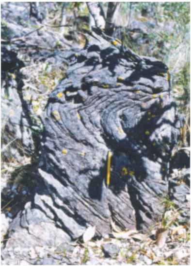
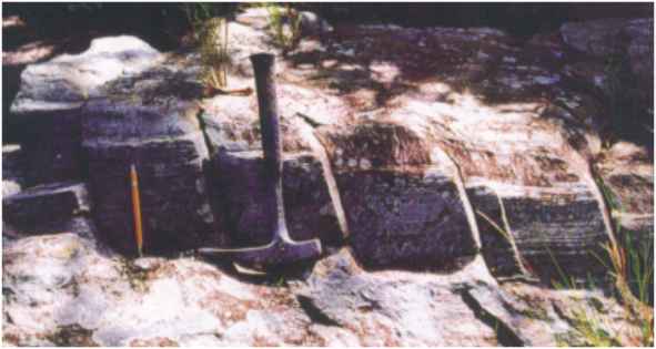
Photography 9 – Herringbone cross stratification. The upper
set indicates flow to north/northeast, while the bottom one show flux direction from north
to south/southeast.
Intermediate Metasiltstone: MS2
The MS2 unit overlies concordantly the Q2 quartzite.
They are weathered foliated metasiltstone with brownish marks interpreted as weathered
carbonates. These rocks represent the low lands of the CVNP, associated to the isolated
so-called Ferro de Engomar, Chapéu and Conceiçăo hills. Fine to medium quartzite
intercalations with low hummocky and tabular cross stratification are present. The
thickness is variable from 50 to 100 meters. The depositional conditions are interpreted
as the external shelf associated to storm events.
Upper Quartzite: Q3
The Q3 unit is represented by fine to medium, white,
micaceous, weathered quartzite sequence, with tabular cross stratification. The thickness
is about 125 meters. The Q3 quartzite is responsible for the
preservation of the scarps observed in the south portion of the park, which show important
landscapes of geomorphological interest. A tidal reworking environment represents the
sedimentation.
Upper Metasiltstone: MS3
The MS3 unit overlies concordantly the Q3 quartzite
and represents the last unit of the Araí Group in the CVNP region. This unit is recovered
in erosive discordance by the Săo Miguel conglomerate (base of the Paranoá Group) that
is distributed southward. The MS3 metasiltstone show a massive aspect,
they are generally grey to greenish grey and contain carbonaceous intercalations, when
they turn dark grey to black. The rich carbonaceous layers may present fine sand
intercalation and show abundant quick sand structures (photography 10). The metasiltstone
are folded, but commonly dipping south about 5 to 10ş. A pervasive cleavage is
observed. The sedimentation is related to a calm deep marine environment. However the
sandy intercalation show HCS and wavy undulations that represent the episodic influence of
storms during the sedimentation. At the top of the unit, lenses of intraclastic and
oolithic limestone may be observed in the Săo Miguel River, immediately below the basal
Paranoá Group conglomerate. This carbonate facies is associated to regressive events
related to the final stages of the Araí Basin sedimentation.
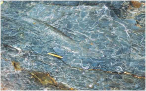
Photography 10 – Quick sand structure developed in the
early stages of the diagenesis, when the sand was forced out because of the conate water
expulsion due to the burying of basin.
SANTANA RIDGE
This corresponds to the northern portion of the CVNP where the
stratigraphy observed is totally different from that one described to the Rio Preto Ridge
(the stratigraphhy presented was defined in the trail of the old "Chiqueirinho"
quartz mining.
Aeolian Quartzito: Qe
Over the granitic basement, there is a sequence of fine white quartzite
showing metric cross stratification typical of eolic sedimentation (photography 12). The
thin section analysis shows bimodal laminations and locally well rounded grains. The
thickness of the Qe unit is between 50 and 70 meters.
Photography 11 – Cross stratification set. The aspect of
high angle at top and low angle in the base is typical of aeolian origin
Conglomerate: Cg
The conglomerates overlie the eolic quartzite. This unit is
characterized by a thick sequence of conglomerates with clasts composed essentially by
intraformational quartzite, less or more rounded or elongated which depositional
environment is interpreted as storm beach deposits. This unit reaches thickness up to 20
meters. The lateral distribution shows a lenticular pattern and its continuity, although
not well defined, seems to overlap the limits of the park (the conglomerate has been
observed in the Cavalcante Ridge). Locally there are intraformational conglomerates,
supported by the clasts, with angulous fragments (breccias) with little sandy matrix
related to gravitational flux in fault scarps.
Upper Quartzite: Qs
After the conglomerates, there is a quartzite sequence with cross
stratification and little cut and fill channels that are related to a tidal depositional
environment. The thickness is estimated to be between 50 and 100 meters.
The figure 3 shows the integrated stratigraphy defined by the main
geologic sections and the figure 4 detail of two schematic geologic sections that show the
distribution of the units.
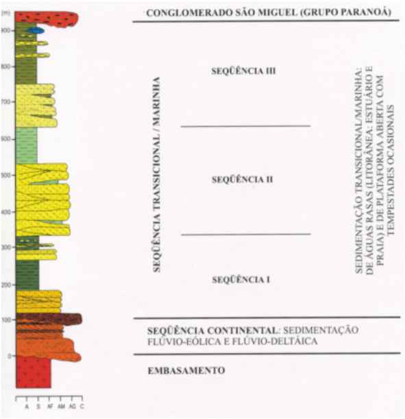
Figure 3 - Integrated stratigraphy of the Chapada dos Veadeiros
National Park. The great majority of the sites are preserved in the Q2 Unit.
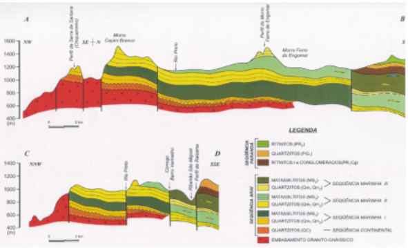
Figure 4 - Two schematic sections, showing the spatial
distribution of the main units that constitute the geology of the CVNP.
Paleogeography
In a general view the paleogeography in the CVNP area is related to the
evolution of an intracratonic rift, where the basal sediments of the Araí Group show the
continental environments (sin rift phase) and the marine sediments of final stage
characterize the post rift phase. This basin gets deep northwards and probably towardss
west. Two mega sequences were identified, the basal continental one and the transgressive
marine one (figure 5). The marine mega sequence show three transgressive cycles, with
finning upward sequence, characterized by sandy sediments at base and pelitic ones
towardss the top of each cycle. The main terrigenous apports were from north to south, how
can be shown by the preliminary paleocurrent data obtained from cross stratification
structures.
At north, in the Santana Ridge, the presence of aeolian and
conglomeratic facies may mark the northern limit of the marine facies. Regionally these
continental facies seem to be distributed until next to the Cavalcante Town, around the
gneiss granitic nucleus.
Part of the conglomeratic facies (breccias) must represent talus
deposits of basin margin or faults scarps. In areas uplifted by WE faults, the psefitic
products are reworked by the storms in a beach environment.
The paleocurrents in the Q2 quartzite indicate
intense tidal influence, showing variable flux direction and even for opposite direction.
The main poles indicate 300/350o and 170o azimuths.
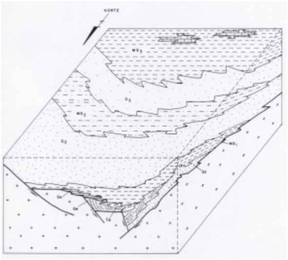
Figure 5 – Diagram block showing schematically the regional
distribution of the main sedimentary facies. Data from geologic mapping in areas located
northward confirm the position of the source areas.
Structuration
The CVNP area is situated in a stable area (in the tectonic point of
view), where the sediments of the Araí Group lie over the gneiss granitic basement.
However, the region is intensively affected by a ruptile tectonism characterized by the
presence of great transcurrent and normal faults that modify the sedimentary sequence of
the Araí Group. Four different structures assembly was distinguished:
1- Transcurrent faults – the most important structures are
parallel to the sedimentary layers, striking N60E. These structures affect
indiscriminately the gneiss granitic basement and the Araí Group sediments, by
milonitization of the basement and perturbation of the sedimentary succession. Regionally
these structures are related to the fracturing parallel to the main direction, locally
"en echelon" (photography 13). Some large quartz bearing veins are
associated to these faults. The movement of the transcurrent faults is dextral, and is
responsible in the NE portion of the CVNP for the development of folds with axis varying
from N60-70E to NS (Fonseca & Dardenne, 1995). At the southwest of the park a
transcurrent fault runs along the contact between the Araí and the Paranoá groups.
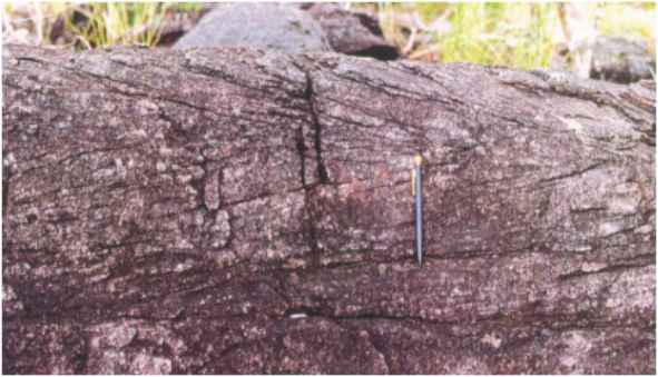
Photography 12 – Detail of fracturing showing escalated
pattern developed in a quartzite layer intercalated in metasilstone sequence.
2 – Normal faults and fractures – some apparently normal
faults show regional importance, with directions varying from N30-60 E to N30W. The main
N30E direction is characterized by quartz vein filling, which has been intensively
explored by garimpeiros. A pervasive fracturing is typical in the area with vertical
attitude of N60E to N40-60W. The N40-60W fractures are also na important quartz vein
control.
3 - Cleavage/schistosity – in all the area a pervasive cleavage
showing variable direction can be observed, but the main attitude is N30E dipping to
southeast. This cleavage is locally well defined in the quartzite, evolving to a
schistosity in the metasiltstone, and indicates the occurrence of compressive stress from
NW to SE. In the pelitic rocks, the foliation can be defined as a slate cleavage.
4 - Folds – in general in the CVNP there are just open folds,
reflecting the large ondulations observed in the isolated hills along the road from the
Alto Paraíso town to the Săo Jorge Village. In the northeastern portion of the park the
NS and N20E folds well preserved in the Araí Group are rotate to the N60-70E direction by
the transcurrent fault called Cavalcante-TerezinaTranscurrent System (Fonseca &
Dardenne, 1995). They are represented by holomorphic folds with vertical axial plane or
dipping westward and promoting layers thickening, what is well observed in aerial
photographs and satellite images.
Geomorphology
In the CVNP region and neighbourhood three geomorphological
compartments can be defined and the evolution of the relief pattern is related to the
bedrock and tectonic structuration. The compartments are called the Rio Claro Valley
Region, Ridge Region and Highlands Region. The Rio Claro Valley Region corresponds to the
low lands, with plane to undulated terrain, developed at 400 meters over granitic basement
rocks. The boundary between this compartment and the Ridge Region is evidenced by a great
scarp with SW-NE general direction and with 40 km long, that represents the northern limit
of the park.
The Ridge Region is located in the middle-northern portion of the park,
including the Rio Preto, Santana, Capim Branco and all areas of high lands in the south of
the park (south of the Cordovil and Săo Miguel streams). This geomorphological
compartment is related to the bedrock where quartzite is the dominant petrographic type,
and where the greatest altitude are observed (1,200 and 1,500 meters). In the north
portion the scarps are supported by the Araí Group quartzite while southward the ridges
are related to the basal Paranoá quartzite (mainly the Q1 and Q2
units). The road that links the Alto Paraíso Town to the de Săo Jorge Village is
situated along a plane region between two high lands associated to the Araí quartzite
(towards north) and to the Paranoá quartzite (towards south).
The Highlands are distributed along the central portion of the park and
are characterized by plane relief pattern with some isolated tabular hills that mark the
regional landscape, among them the Baleia Hill, Palha Virada Hill, Peito de Moça Hill and
the Ferro de Engomar Hill.
The soil coverage is characterized by cambisoils and litholic soils.
The hidromorphic soils are observed in the great majority of the spring regions. The Tręs
Lagoas region is a very beautiful area associated to hidromorphic soils, with specially
adapted vegetation. The vegetation cover is characterized by typical savanna in the great
part of the region. Along river and stream valleys the ciliar forest is commonly observed.
The CVNP area is important in the geomorphological point of view,
because in its limits rare geomorfological compartments are preserved, and the study of
the origin and evolution of these features is useful to the understanding of the
geodynamic regional processes. In the region landscape the most elevated point of the
Middle-West region of Brazil with altitude superior than 1.700 meters is found (Boa Vista
Ridge, next to the western limit of the CVNP).
PRESERVATION PROGRAM
As the CVNP is a region of environmental protection, the great majority
of the areas with geological or geomorphological interest are preserved. However there are
areas, especially those out of the CVNP limits, where the risks of degradation really
exist. The risks are related to the bad management of the touristic exploration. The main
problems are listed as following:
- Waste accumulation in the visiting areas and neighbourhood;
- Pitching of natural monuments (as locally observed);
- Reactivation of erosive processes in bad programmed trails;
- Elimination of the native vegetation for the construction of trails and roads.
To get improvement in the touristic exploration of the CVNP several
measures can be taken on, mainly in the sense of getting a more cultural character of the
local ecoturism exploration. The visitors may be informed about the genetic aspects of the
structures observed, of the landscapes, of the rock formation and some other features of
the natural environment, which are important for the space transformation. Among these
measures the following can be listed:
- Production of spelling books in simple language, with the main aspects of the general
environment;
- Distribution of plates with local references of the most important types of rocks and
formation environment and sedimentary structures, type of geomorphological compartment and
so one;
- Restriction to the number of simultaneous visitors in each point of visitation.
REFERENCES
ARAÚJO, V.A. & ALVES, A.C. 1979. Projeto Cana
Brava - Porto Real. Relatório Final. DNPM/CPRM. Goiânia 5 Vol.
BARBOSA, O. et al. 1969. Projeto Brasília - Goiás: Geologia e
inventário dos recursos minerais. DNPM-PROSPEC. 2 vol.
CORDANI, U.G. & HASUI, Y. 1975. Comentário sobre os dados
geocronológicos disponíveis para a Folha de Goiás. Carta Geológica do Brasil ao
Milionésimo. Brasília. p. 85-95.
DYER, R.C. 1970. Grupo Araí, um grupo de metamorfitos do centro leste
de Goiás. Rev. Esc. Minas, 28(2). Ouro Preto.
FARIA, A. de 1995. Estratigrafia e sistemas deposicionais do Grupo
Paranoá nas áreas de Cristalina, Distrito Federal e Săo Joăo D’Aliança-Alto
Paraíso de Goiás. Universidade de Brasília. (Doctorate Thesis). 199p.
FONSECA, M.A. & DARDENNE, M.A. 1995. Tectônica transpressional no
contexto do núcleo metamórfico externo da Faixa Brasília em seu segmento setentrional.
5o. Simp. Geol. Centro-Oeste. SBG, Núcleos Goiânia e Brasília. p. 84-86.
HASUI, Y. & ALMEIDA, F.F.M. 1970. Geocronologia do Centro-Oeste
brasileiro. Bol SBG 19(1):5-26. Săo Paulo.
HASUI, Y.; HENNIES, W.T. & IWANUCH, W. 1975. Idades K-Ar do
Pré-Cambriano da regiăo centro norte do Brasil. Bol. Inst. Geoc., USP. 6:77-83. Săo
Paulo.
MARINI, O.J.; FUCK, R.A.; DARDENNE, M.A. & DANNI, J.M.C. 1984.
Província Tocantins - Setores Central e Sudoeste, in: Almeida, F.F.M de & Hasui, Y. O
Pré-Cambriano do Brasil. p. 251-299.
PIMENTEL, M.M.; HEAMAN, L.; FUCK, R.A & MARINI, J.O. 1991. U-Pb
zircon geochronology of Precambrian tin-bearing continental type acid magmatism in central
Brasil. Precambrian Res. 52:321-335.