
SIGEP
Geological and
Paleontological Sites of Brazil - 095
SERGI RIVER CANYON
Date: 01/04/2000
Augusto J. Pedreira
augusto.pedreira@terra.com.br
CPRM – Geological Survey of Brazil
Avenida Ulysses GuimarŃes, 2862 -
Centro Administrativo da Bahia
41213-000 Salvador, Bahia, Brasil
® Pedreira,A.J. 2000. Sergi River Canyon, Brazil. In: Schobbenhaus,C.; Campos,D.A.; Queiroz,E.T.; Winge,M.; Berbert-Born,M. (Edit.) SĒtios Geol¾gicos e Paleontol¾gicos do Brasil. Published
01/04/2000 on Internet at the address http://www.unb.br/ig/sigep/sitio095/sitio095english.htm [Actually
https://sigep.eco.br/sitio095/sitio095english.htm]
[SEE PRINTED CHAPTER IN
PORTUGUESE]
(The above bibliographic reference of author copy rights is required for any use of this article in any
media, being forbidden this use for any commercial purpose) |
ABSTRACT
In the low course of the Sergi river, about seven kilometers
northwest of the town of Santo Amaro, Bahia State, there is a deep canyon cut into
sandstones that crop out along the western border of the Rec¶ncavo Basin, of Mesozoic
age. These sandstones, described for the first time in the forties, were named Sergi
Formation. Their age is neo-jurassic and they constitute the main petroleum reservoir of
that basin. The Sergi Formation deposited before the rifting that gave birth to the
Rec¶ncavo Basin, belonging to to Sequence of the Continent. It is underlain by the
Alianńa and Afligidos formations, of the same sequence. In the Sergi Formation were
recognized two facies: a fluvial facies composed by medium scale cross bedded coarse
grained sandstones, and an eolian facies that comprises fine grained sandstones with
medium grained laminae, and large scale cross bedding. These can be of tabular or trough
types and are in sets separated by horizontal beds that represent 1st. order
bounding surfaces. The surfaces that separate cross bedded sets of different dips are
interpreted as 2nd. order bounding surfaces. Between some horizontally bedded
sets interpreted as interdunes, there are beds with convolute stratification that result
from the deformation of water saturated sediments. The
diverse sedimentary structures of the Sergi Formation sandstones are interpreted
as composed and complex dunes separated by interdune areas, in a neo-jurassic
sand sea.
INTRODUCTION
Close to the western limit of the Rec¶ncavo Basin, the oldest oil producing basin of
Brazil, there is a north-south trending sandstone crest tens of kilometers long. In this
crest, the Sergi river scoured a canyon more than a hundred meters deep, that runs since
the Sergi station in the railroad that connects the towns of Cachoeira and Santo Amaro,
until close to its confluence with the Subaķ river. This region, known since long time
ago, began to be geologically studied in the first half of the forties, in the beginning
of the oil exploration in the basin, since the rocks that crop out there are its major oil
reservoir (Lanzarini, 1996). In the escarpments of the canyon, the rocks show sedimentary
structures indicative of eolian and fluvial processes that occurred more than 150 million
years ago. Besides the geologic aspects, the tributaries of the Sergi river in both
margins of its valley when enter in the canyon, form water falls that add beautiful
landscapes to the geologic features.
LOCATION
The Sergi River Canyon is located about seven kilometers northwest of the town of Santo
Amaro (Bahia State , Brazil), ) limited by the coordinates
12o 27' S-12o 33' S and 38o 45' W- 38o 50'
W, in the valley of the Sergi river (figure 1). This river, the
main tributary of the Subaķ river that crosses that town, has its source close to the
town of Feira de Santana, discharging in it after traversing the canyon.
From the city of Salvador, the site is reached through the Salvador-Feira de Santana
highway (BR-324), until its junction with the BR-240 road, that connects the towns of
Santo Amaro and Cachoeira.
From the town of Santo Amaro, there are at least two alternatives to arrive at the
canyon: the first one is to follow the road to Campinhos, until its junction to the
village of Pedra, leaving the vehicle at the first railway crossing of the latter road and
walking along the railroad (about 5km) northwestwards until the Cabeńa do Cavalo bridge..
The second alternative is to follow the BR-420 road 22km towards the town of Cachoeira and
entering in the village of Cepel, drive to the locality of Jambeiro; leaving the vehicle
there, walk downhill until the Sergi station in the river valley and walk along the
railroad towards the town of Santo Amaro.
HISTORICAL DATA
Along the fault that borders the Rec¶ncavo Basin by the west, there are parallel belts
of sandstone cuestas, forming long escarpments (Ghignone, 1979). That fault passes trough
the towns of Amķlia Rodrigues, Campinhos, Afligidos and Maragojipe (Figure 1).
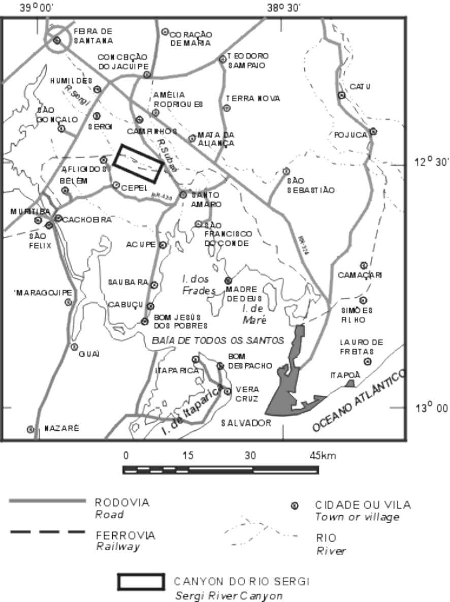
Figure 1 - Location of the Sergi River Canyon
Sandstones that compose one of these belts were described in the valley of the Sergi
river, along a stretch of about 5km between the km 89 of the railroad and the Sergi
station (Figure 2). They were named Sergi sandstone, as a member of the Brotas Formation,
by the geologist E.F.Taylor, of the former National Petroleum Council (Taylor, 1948; after
Baptista et al., 1984). According to the original definition, it is a white, red, purple
and tan, coarse to medium grained, arkosian, friable sandstone, with quartz pebble zones
and siliceous concretions with 5cm diameter; the sedimentary structures described then,
were cross bedding. The thickness of the formation ranges from 9 to more than 90 meters, in the western
border of the basin, attaining a maximum of 440m in Itaparica island.
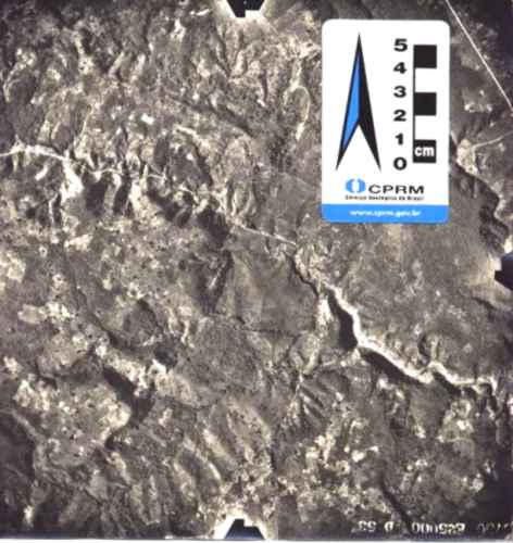
Figure
2 - Aerial photograph (Petrobrßs/LASA, Flight 53-D, 1959, 1:25.000
scale), showing the regional geology: at the left side, the Precambrian
basement, separated from the basinal sediments (Afligidos and Sergi formations)
by a fault. The canyon is below the scale and its arrow indicates the north.
In 1958, the Basin Study carried out by the Petr¾leo Brasileiro S.A .-Petrobrßs
(Viana et al.,1971), changed the rank of the Brotas Formation to group and of the Sergi
sandstone to formation, maintaining the original stratotype. Its age, presumed to be Late
Jurassic, is indicated by the presence of Tithonian non-marine ostracodes; the Tithonian
in the Rec¶ncavo Basin takes the local name of D. JoŃo Stage. Ghignone (1979) adds that
the quartz pebbles form conglomerate lenses, occurring other ones of micaceous siltstone,
both with irregular distribution, and that the Sergi Formation was recognized in Africa
with the name of M ' Vily.
The Sergi Formation is part of the Continent Sequence (Asmus & Porto, 1980), having
been deposited before the rifting that gave birth to the Rec¶ncavo basin (Pre-rift Phase;
Caixeta et al., 1994), together with the underlying Afligidos and Alianńa formations
(Figure 3). Its contact with the Alianńa Formation is gradational or through channels
with irregular bottom (Ghignone, 1979).
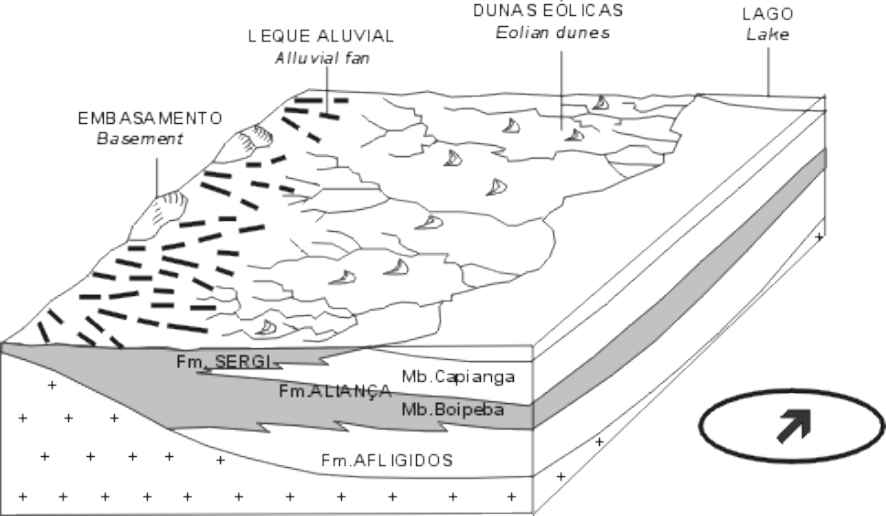
Figure
3 - Depositional model for the pre-rift alluvial, fluvial, eolian and
lacustrine sediments of the D.JoŃo Stage, encompassing Afligidos, Alianńa and
Sergi formations. Modified from Medeiros & Ponte (1981).
In the Sergi River Canyon, Medeiros & Ponte (1981) recognized two facies in the
formation: 1) eolian facies comprising fine grained sandstones with coarse grained
laminae, large scale cross bedding with faceted pebbles where the bedding laminae are
tangent to the lower bed surface; and, 2) fluvial facies composed by conglomerates and
coarse grained sandstones with medium scale cross bedding.
Studying in detail the eolian sediments above described, Lanzarini (1996) identified
dunes and interdunes-sand sheets, interpreting the former as large scale bed forms 500 to
1000m long and tens of meters high. They are stacked barcanoids with strata limited by
bounding surfaces due to the migration of foresets according to subcritical angle. These
dunes may be associated to other forms of similar scale, composing draas in a Jurassic
sand sea.
Using geoprocessing in order to minimize the distortions of field photogrammetry,
Carrasco et al. (1996), interpreted the faciology of the Sergi Formation in the canyon as
resulting of the piling up of dunes and interdunes. Besides the dunes described by
Lanzarini (1996), they tracked three more facies interpreted as interdunes, deformations
and bounding surfaces. The interdunes consist of sand deposits with almost horizontal
lamination, intercalated to the dune deposits; their length is of a few hundreds of meters
with thickness of 1.5 to 2.5m. The deformations are chaotic deposits subordinated to the
dunes, developed by overburden on water saturated sediments below the water table.
These deformations are characterized by convolute structures, without associated faults; their length ranges
from 30 to 80m and their thickness in four meters. The bounding surfaces indicate the
migration of dune fields (1st. order); are positioned between dunes indicating
the passage of a migrating dune over a stationary one (2nd. Order); and form
bands of cross lamination within the stratification cosets (3rd. order).
DESCRIPTION OF THE SITE
The Sergi river canyon occupies a long extension however, the proposed site is
restricted to the stretch between the Cabeńa do Cavalo bridge and the Sergi station along
the railway, because of its relatively easy access and the excellent exposures. Close to
the western bridge head, already exist some railroad cuts where crops out the Sergi
Formation, represented by friable sandstones with large scale tabular cross bedding
(Figure 4).
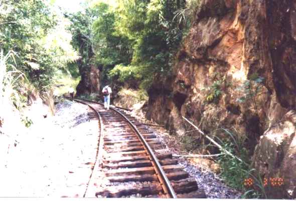
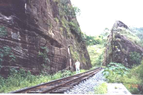
Figure
4 - Railroad cut west of the Cabeńa do Cavalo bridge.
After crossing the bridge, the escarpments tabular show large scale cross beds
indicative of dunes and 1st and 2nd order bounding surfaces, similar
to those studied by Carrasco et al. (1996)
(Figure 5).
Figure
5 - Large scale tabular cross bedding in the lower half of the outcrop,
and horizontal bedding in the upper one.
The 1st order bounding surface is represented by the horizontal
stratifications separating the cross bedding cosets, that are interpreted as migrating
dunes. The 2nd order one is the inclined line from the left to the right in the
lowest coset, that separates two sets of different dips. From this place are seen the
escarpments that form the canyon (Figure
6).
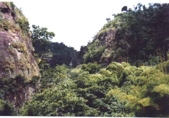
Figure
6 - Escarpments of the Sergi river canyon
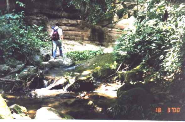
The tributaries of the left and right banks of the Sergi river form water falls several
heights, whose flow increases or decreases according to the season of the year (Figure
7).
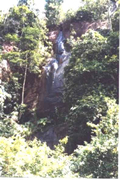
Figura
7 - Small water fall formed by a tributary of the Sergi river left bank,
photographed in middle march.
The escarpments in the right bank of the river show large scale tabular cross bedding
separated by 1st order bounding surfaces (Figure
8) that represent draas in a
sand sea (Lanzarini, 1996).
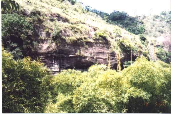
Figure
8 - Two sets of large scale tabular cross bedding, separated by a first
order bounding surface.
A large tributary of the right bank forms inside the canyon the Urubu water fall. To
reach it is necessary climb down from the railroad and ford the Sergi river, following the
trail shown in the Figure 9, that crosses the forest that hides the water fall.
Figure
9 - Trail to the Urubu water fall, among moss covered sandstone boulders.
The Urubu water fall is about 20m high and in its foot there is a very deep small lake.
In the Figure 10, at the right of the water fall a bed shows large scale tabular cross
bedding. The paleowinds that formed these cross beds blew alternatively from left to right
and vice-versa. This type of cross bedding may be found in longitudinal dunes (seif), in
the "horns" of bachanoid dunes and in the arms of star (rhourd) dunes.
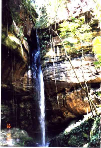
Figure
10 - Urubu water fall
In the right bank escarpment of the canyon one may see the outcrop studied by Carrasco
et al.(1996) (Figure
11), with convolute stratifications interpreted as the result of water
saturated sediments deformation, large scale trough cross bedding and horizontal bedding
interpreted as dunes and interdunes, as well as 1st, 2nd and 3rd
order bounding surfaces (Figure
5). This escarpment is upstream of the river that forms
the Urubu water fall.
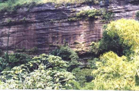
Figure
11 - Escarpment about 50m high, in the southern wall of the canyon. The
sector between the lines of vegetation is about fifteen meters thick.
PROTECTIVE ACTIONS
Presently there are no protective actions in the site. However, as the area is sparsely populated
and rather far from urban centers, they may be restricted to the improvement of the access in the side
of Sergi station and to the Urubu water fall. In this one, the stone walls are carved with
the names of visitors and, owing to the friability of the sandstones, generally the names
are deeply carved, being impossible their remotion.
REFERENCES
Asmus,E.H.;
Porto,R. 1980. DiferenciańŃo nos estßgios iniciais da evoluńŃo da margem
continental brasileira: possĒveis causas e implicań§es. In: SBG, Congresso
Brasileiro de Geologia, 31, Cambori·, Anais, 1: 225-233.
Baptista,M.B.;
Braun,O.P.G.; Campos,D.A.C. 1984. Lķxico
Estratigrßfico do Brasil. BrasĒlia, CPRM, 560 p. (ConvĻnio DNPM/CPRM).
Caixeta,J.M.;
Bueno,G.V.; Magnavita,L.P.;
Feij¾,F.J. 1994. Bacias do Rec¶ncavo, Tucano e Jatobß. Boletim de GeociĻncias
da Petrobrßs, 8 (1): 163-172.
Carrasco,B.N.;
Fonseca,L.E.N.; DurŃes,E.M. 1996.
FotointerpretańŃo de fßcies e elementos arquiteturais e¾licos no
afloramento do Canyon do Sergi, Bacia do Rec¶ncavo, Brasil. In: SBG,
Congresso Brasileiro de Geologia, 39, Salvador, Anais, 1:
141-144.
Ghignone,J.I. 1979. Geologia dos sedimentos
faneroz¾icos do estado da Bahia. In: Inda, H.A .V., org., Geologia e
Recursos Minerais do Estado da Bahia; Textos Bßsicos. Salvador,
SME/CPM, p. 23-154.
Lanzarini,W.L. 1996. Geometria das unidades
genķticas fluviais e e¾licas das formań§es Alianńa e Sergi na borda oeste
da Bacia do Rec¶ncavo. In: SBG, Congresso Brasileiro de Geologia, 39,
Salvador, Anais, 1: 328-331.
Medeiros,R.A.;
Ponte,F.C. 1981. Roteiro Geol¾gico da Bacia do Rec¶ncavo. Salvador,
Petrobrßs/SEPES/DIVEN/SEN-BA, 63 p. (Acordo Petrobrßs-SENAI).
Taylor,E.F. 1948. Estado da Bahia. In:
Brasil. Conselho Nacional do Petr¾leo. Relat¾rio de 1946. Rio de
Janeiro, p. 148-172.
Viana,C.F.;
Gama Jr.,E.; Moura,J.A.;
Fonseca,J.R.; Alves,R.J. 1971. RevisŃo
estratigrßfica da bacia do Rec¶ncavo/Tucano. Boletim Tķcnico da Petrobrßs,
14 (3/4): 157-178.