
SIGEP
Geological and Paleontological
Sites of Brazil - 092
THE ISLAND OF
TRINDADE
Date: 23/01/2000
FERNANDO F.M. DE ALMEIDA
ffma@uol.com.br
Departamento de Minas, Escola Politécnica
Universidade de São Paulo
© Almeida,F.F.M. 2000. The Island of Trindade. In: Schobbenhaus,C.; Campos,D.A.; Queiroz,E.T.; Winge,M.; Berbert-Born,M. (Edit.) Sítios Geológicos e Paleontológicos do Brasil. Published
23/1/2000 on Internet at the address http://www.unb.br/ig/sigep/sitio092/sitio092english.htm
[Actually
https://sigep.eco.br/sitio092/sitio092english.htm]
[SEE
PRINTED CHAPTER IN PORTUGUESE]
(The above bibliographic reference of author copy rights is required for any use of this article in any media, being forbidden the use for any commercial purpose) |
ABSTRACT
The small Trindade Island is situated in the South Atlantic Ocean approximately at the
parallel of Vitória, Espírito Santo, and 1,140 km far from the coast. It is the eroded
top of a big volcanic mountain that is part of an alignment of volcanic submarine
mountains. It rests on the ocean floor approximately 5,500 m deep. The relief is extremely
irregular for an island area of 13,5 km², where three peaks as high as 600 m stand out.
The rocks comprise sodium-rich and silica-subsatured lavas and intrusions, as well as
several pyroclastic rocks. Alga reefs, narrow beaches and, very locally, dunes, small
fluvial deposits on the coast, several cones and slope aprons are everything that exists
in this island almost totally composed of volcanic and subvolcanic rocks formed between
the end of Pliocene and Holocene. It is the only place in the Brazilian territory where
part of a volcanic cone is still recognizable. The island has no permanent settlement, but
has been periodically occupied by the Army and visited by researchers. Throughout a
history of five centuries, since its was discovered, the island became uninhabited by long
periods, allowing some foreign invasions. Due to its distance to the coast, access
exclusively by the sea and difficult conditions to disembark, Trindade offers no
conditions for tourism activities, but it is a special place for scientific
investigations.
INTRODUCTION
As the Fernando de Noronha archipelago, the Trindade Island offers great interest for
research on the origin and differentiation of magmas that traverse the oceanic crust. Far
from the continent as it is, without tourism facilities and accessible only by the sea
(Photo 1), the island still has kept many of its primitive aspects for ecological
investigations.
SITUATION
The island, far 1,140 km from the coast, is situated at the 20º 30'S and 29º 18' WG,
approximately on the Vitória parallel, Espirito Santo State. Its isolation on the ocean
surface precludes the realization that it is part of the Vitória-Trindade Alignment, a
great E-W submarine volcanic chain. The volcano lies on the ocean floor about 5,500 m
deep. Other volcanic buildings belonging to this lineament between Trindade-Martim Vaz and
the coast were completely eroded by the sea, and leveled above 100 m depth. They compose
the guyots, usually called banks, but the islands, probably due to the prolonged volcanic
activity, are still high above the oceanic surface.
HISTORY
The island was discovered by João de Nova, a Spanish navigator working for Portugal,
who departed from Lisbon in 1501. He named it Assunção, but in the following year it was
replaced by Trindade by Estevão da Gama, during a visit to the island. In 1700 Edmond
Halley, the famous English astronomer, judging to have discovered a new island, occupied
it in the name of England. The Portuguese settled there in 1756, but the British Army
returned there in 1781, abandoning it soon afterwards. The Portuguese tried to fortificate
and colonize it by açoreans, but without success. During the two World Wars Trindade
received military expeditions, and in 1924 it became a political prision. In 1957 the
Brazilian Navy established the Oceanographic Station of the Trindade Island (POIT), and
since then expeditions have frequently been there, to undertake meteorological
observations and try to reforest it.
Starting from the XVIII century explorers and scientists members of the following
expeditions visited the island: J. Cook in 1775, J. C. Ross in 1839, the ship Challenger
in 1876 and La Pérouse in 1887. The contribution to Geosciences, however, was very
reduced. M. L. A. Milet-Mureau (1797) of the La Pérouse expedition recognized the
existence of basalts and G. T. Prior (1900), examining the material collected by the Ross
expedition, stressed out the volcanic nature of the island and its similarity to Fernando
de Noronha. Several scientists took part of the expedition conducted by João Alberto Lins
de Barros in 1950. Among them were the geologists J. R. de Andrade Ramos (1950) and R. V.
Veltheim (1950); the latter produced the first geological sketch of the island. L. de C.
Soares in 1964 published a synthesis of the geology and geography of Trindade. The present
author stayed there two months in 1958, when he produced the geological map at the
1:10,000 scale and in 1961 published the results of the petrographic and geochemical
studies. U. G. Cordani (1970) divulged the result of 36 age datings by the K-Ar method of
rocks he collected. In 1990 B. L. Weaver undertook a geochemical study of rocks from the
collections of the British Museum.
DESCRIPTION OF THE SITE
GEOGRAPHICAL ASPECTS
This small (2.5 km wide) island does not exceed 13.5 km² in area. It shows a very
irregular relief (Photo 2): peaks at its central region are as high as 500 or 600 m. The
relief is a result of erosion processes on a heterogeneous rock massif in regard to the
resistance offered to the destructive agents. The higher central region of the island is
composed by phonolitic, nefelinic and grazinitic sub-horizontal flows and associated
pyroclastic rocks, belonging to the Desejado Sequence. They form an axial plateau above
350 m of irregular relief where the Desejado Peak outstands. This highest point of the
island (640 m), as well as the São Bonifácio and Trindade, both between elevations of
550 and 600 m, were formed on phonolitic extrusions. Three principal streams of the island
start from the Desejado Peak and many ravines. Below this plateau rocks of the Trindade
Complex reach the coastline. Steep rock slopes and scarps, more or less abrupt, compose
the coast formed mainly by pyroclastic rocks and phonolitic intrusions, including a number
of dikes of varied rocks (Photo 3). Some pinnacles outstand as domes, necks and plugs and
large phonolitic dikes exposed by the differential erosion and slope retreat. The 270 m
high Monumento Peak is among them (Photo 4), in the south coast. The relief in the eastern
region of the island is lower, exhibiting ankaratritic lavas of the Vermelho Mountain and
Paredão volcanoes. The former has flowed seawards into the northeast island coast. The
associated pyroclastic rocks form a small plateau inclined in the same dip direction.
Formerly, the Vermelho creek drained the lava area flowing into northeast but it was
captured into the Principe beach on the south coast thus forming the deepest canyon of the
island (Photo 5). The Paredão Volcano at the extreme east of the island is a proof of its
younger volcanic activity. It has been eroded by the sea, along scarps of about two
hundred meters high. The abrupt slopes of the Trindade Complex and the phonolitic peaks
have the base covered by cones and slope aprons, constituted by rock blocks of varied
dimensions that fall from the scarps. Dejection cones are common, normally dry, from the
flows descending from the scarps, mainly in the north coast. Nowadays the alluvial cone of
the Vermelho Creek is being eroded at the Principe Beach. Narrow beaches exist mainly on
the northeast island coast, where restrict reefs of Lithothamnium algae also
develop. Dune deposits form in some parts of the coast, such as the one at the Tartarugas
Beach.
The Trindade island platform has a restrict area; the width varies between 800 and
3.000 m. Besnard (1951) surveyed 16 radial echobathimetry profiles around the island.
Almeida (1961) identified slope ruptures on them, some well-defined close to 59 and 77 m.
It has been interpreted as the corresponding erosion levels produced by transgressive or
regressive seacoasts. They may be correlated to two of the ruptures traced by Shepard and
Wrath (1937) in continental platforms of many parts of the world. The marine abrasion
terrace is 3,5 m high and one hundred meters wide around the Paredão Mountain, where it
is affected by waves.
The island has a semi-wet tropical climate, trending to semi-arid. The annual mean
pluviosity is low and two stations, the dry one from January to March. This is the hottest
period and July the coldest month (Barros, 1950). The island is under the influence of
trade winds from southeast.
A low, campestral type, vegetation dominates the lowlands and surfaces of ankaratritic
volcanism as well as the areas of pyroclastic rocks on the axial plateau. Herbs, grass and
ciperaceae (Photo 6) occur there. Arboreal vegetation occurs on the axial plateau along
the slopes on the phonolitic mountains. It is of special attention the communities of
giant fetus arborescent (Cyathea trindadensis): polypodies (samambaias) attaining 6-m
height.
REGIONAL GEOLOGY
We distinguish in Trindade five volcanic episodes: the younger four are clearly
discernible, but the oldest is complex, corresponding to the Trindade Complex. It
is composed by pyroclastic and intrusive rocks exposed on slopes of the major part of the
island. It represents the oldest visible volcanic activity above the sea level. The oldest
rocks of the complex may be well recognized on the low parts of a hill at the Cachoeira
Inlet (Photo 7). They are lapilli tuffs containing blocks of tannbuschitic rock (a variety
of olivine nefelinite composed essentially by crystals of pyroxene with small quantity of
nefeline and olivine). The major part of the complex is formed by varied pyroclastic rocks
associated to the phonolitic volcanism in beds inclined no more than 30º. At the western
region of the island it reaches a thickness close to 400 m (Photo 3). The pyroclastic
rocks are cut by a number of dikes, mainly nefelinite and phonolite, but also olivine
analcitite, analcite basanite, gauteite and others. Phonolitic dikes at the southwest
region of the island reach a thickness of about 50 m. The complex include 16 large
phonolitic bodies of subcircular to elliptical shape representing endogenous domes, plugs
and necks with diameter of even 400 m on a flank of the Branco Peak. The complex is
crossed by NW and NNW-striking diaclases on the northern slopes of the island, and
NNE-striking at the southern sector. By and large they determine the dike orientations.
The phonolitic pinnacles of Trindade show evidence of more than one single origin. Some
correspond to cylindrical monolithic intrusions of viscous lava (plug domes) as, for
example, the Monumento (Photo 4). Others are toloidal bodies (Staukuppen) growing in the
funneled orifices of the volcanic cones as the Vigia and Desconhecido mountains.
The oldest age obtained by Cordani (1970) for the island rocks was 3.6 Ma, in a dike of
ultrabasic rock cutting tuffs at the Cabritos Beach. The large phonolitic intrusions
indicate ages of 2.3 to 2.9 Ma.
The Desejado Sequence is composed by flows of phonolite, nefelinite and
grazinite (a variety of phonolitic nefelinite containing analcime, but no olivine) with
intercalations of pyroclastic rocks of the same composition. Some of them have clearly
been deposited under non-marine water. This unit reaches a thickness of about 400 m on a
section between the Portugueses Beach and the Desejado Peak (Photo 7). Its base is
approximately at 360 m altitude, clearly corresponding to a erosion surface that truncates
the Trindade Complex (Photos 7 and 8). The topography feature correspond to a structural
plateau of irregular relief - the axial plateau - below the culminant peaks of the island
(Photo 5). The highest of them, Desejado, is a Staukuppe with an exposed base and a
maximum visible thickness close to 160 m. The sequence represents a mixed volcanic
activity, where the explosive extrusion of more viscous phonolitic lavas is interbedded
with the effusion of more fluid flows of grazinite and nefelinite. We argue that the
phonolites underneath the São Bonifacio and Trindade peaks are also Staukuppen, a
possibility that requires further investigation.
The ages obtained for the Desejado Sequence flows lie between 1.60 and 2.63 Ma, a fact
to be confirmed. If so, they do not essencially differ from the younger intrusions of the
complex and the unconformity between this and the sequence is not so important as the
field observations have indicated (1961).
The Morro Vermelho Formation is the result of an explosive eruption of
ankaratritic lava flows, a melanocratic variety of olivine nefelinite containing biotite.
The volcanism affected the high valley of the central island region, filled by lavas and
pyroclastic rocks (Photo 5) in excess of 200 m thick. The lavas flowed towards the insular
platform north of the island and formed a low plateau inclined onto the sea. The
pyroclastic rocks, of varied structure, result from emission of fluid magma, mainly by the
process of fire fountaining. The lavas constitute successive flows of analcite
ankaratrite, being vesiculated and escoriaceous on the top and rarely at the bottom.
Dominated by the block lava type, the individual flow thickness varies from 0.5 m to 40 or
50 m, as it can be seen at the Vermelho Creek canyon (Photo 5). At this side the formation
is thicker than 230 m, where it is mainly composed by flows. The emission center of
volcanic products was close to the Vermelho Mountain where ankaratrite dikes occur. The
volcanism ended when sea level was lower than the present one, which caused the exposure
of the platform.
The Morro Vermelho Formation, according to Cordani (1970) is not older than 170.000
years. The lavas flowed during the world marine regressions that accompanyied the Würm
glaciation stage, between 115.000 and 11.000 years BP.
Valado Formation. The large alluvial cone deposits of the Valado Creek, between the
Cabritos and the Portugueses beaches at the north coast of the island, intercalate
pyroclastic rocks and flows of tannbuschitic lava from an emission center situated upwards
(Photo 9). Pyroclastic rocks are composed by discoid bodies resembling emplasts, lava
filaments, rotating bombs and an agglutination of drop lava masses in a viscous state (Schlackenagglomerate).
The eruption seems to have been processed from a midslope crack, parallel to the present
coast, where several tannbuschite dikes show escoriaceous structure. The slope cones at
the base of two phonolitic mountains cover the possible focus. The Valado alluvial cone
was forming at that time, attesting the young age of the volcanism, so young that could
not be dated. Other detritic acumullations in slope cones, slope aprons and alluvial cones
also include single beds of lapilli tuffs and ash postdating the Morro Vermelho volcanism,
as it can be easily observed at the Vermelho Creek cone. We do consider them related to
the Valado volcanism. At the cone which is being eroded by the sea we noticed that the
horizontal Valado tuffs were covered in angular unconformity by the inclined tuffs of the
Paredão Volcano. It seems doubtless that the Valado volcanism is post-glacial,
considering the island geomorphology.
The Paredão Mountain, at the eastern island extremity, represents the ruins of a
volcanic cone that has been destroyed by the sea, but from which still can be perceived
clear rests of the surface of the original slopes, as well as, rests of its crater border
(Photo 10). It was a small mound formed by pyroclastic rocks with few ankaratritic lava
intercalations. Close to the entrance of a tunnel opened by the sea rests of lava resemble
cheminee fills. The major volume of the mountain is formed by lapilli tuffs containing
blocks, rotational bombs and driblets. At the mountain flank they form inclined beds into
the periphery, as well as into the interior of the crater, where they still locally
remain. Olivine, pyroxene and biotite as isolated matrix cristals are abundant on the
exposed pyroclastic rocks both in the tunnel and as components of the sand of a small
adjacent beach. The relief far from the volcano still presents a cover formed by rests of
tuffs and ash transported by the east wind. The beds are 3 m thick above the Vermelho
Mountain and the Verde Peak and 5 m at the Grazinas Peak, 2,000 m far from the volcano.
The lava flowed mainly northwards and rests of it can be seen at the Tartarugas parcel
(Photo 9) and at the fossile sea cliff close to the Tartarugas beach. The individual
thickness of the lava flows is up to 2 m; they are escoriaceous at the top and interbedded
with pyroclastic rocks. On the island platform partially emerged at that time, a gas-rich
magma formed a 200 m-high volcano cone. The volcano growed mainly by the fire fountaining
process, the lava flowing towards north. The activity was continuous but short in time. It
was late accretted at the top of the big volcanic building when it was largely eroded to
constitute the island platform. It is the only recognizable rest of a volcano on the
surface of the brazilian territory. Due to its young age it can not be dated by the K-Ar
method. Geomorphological criteria was a tool for estimating its age, seeming to be
post-glacial, but prior to the climatic optimum. The younger marine terrace
recognizable on the island can be related to this last time interval, thus the age should
be a few thousands of years.
The volcanic series of Trindade are highly subsatured in SiO2 and strongly
sodium-rich, even more than Fernando of Noronha. From 33 analyses presented by Almeida
(1961) and Weaver (1990) the SiO2 content varies between 37.12% (analcite
ankaratrite) and 52.91% (phonolite). Na2O values concentrate between 2.45%
(basanite) and 13.00% (noseana phonolite). The two oceanic volcanic series are the most
subsatured in silica and the most sodium-alkaline of the Atlantic. Trindade is among the
most sodium-rich of the oceanic series, if not the most sodium-rich series of the world.
As in Fernando de Noronha, the ultrabasic rocks - the denser fractions of the magmatic
differenciates - were expeled late, as it can be judged by what is exposed on the island.
PROTECTION OF THE SITE
In spite of its splendid natural atractions the island does not allow echotourism due
its long distance to the continent, to be accessible only by the sea, difficult and
dangerous to disembark and absence of tourism facilities. Thus, Trindade is protected from
the generally predactory action caused by the tourism. Nevertheless, even considering it
was occupied by a few periods, its ecological equilibrium was severely disturbed. In 1700,
when the astronomer Haley visited it, goats were left on the island. Around 1782, when the
Portuguese unsuccesfully attempted to colonize the island goats and sheeps were introduced
there. Other animals were taken to the island by military expeditions, mainly during the
first World War. Facing no natural enemies, these animals turned back to savage conditions
and proliferate causing severe destruction of the vegetal cover resulting in the
development of stony soils, as on the ankaratritic plateau (Photo 5). Urgent measures are
the extermination of these animals, the preservation of what rests of the original flora
and fauna, still including endemic species, and the reforestation of the soil-favourable
sites. The POIT is acting in this sense and it is expected that someday Trindade may
recover a part of its original vegetation, referred to as exuberant in ancient
descriptions. Crabs, birds, some of them endemics, and marine turtles that spawn on the
island should be properly protected.
Acknowledgements
The author acknowledges Prof. Dr. Carneiro, Prof. Dr. Roberto Perez Xavier and Dr.
Marta Maria Falsetti for their help in the translation of the manuscript into English; Mr.
Marcelo Reginato for carefully drafting the map which illustrate the final text; Prof.
Sérgio Bergamaschi and Biol. Carlos Raposo, for the color photo that ilustrates the
present paper.
Figure Captions
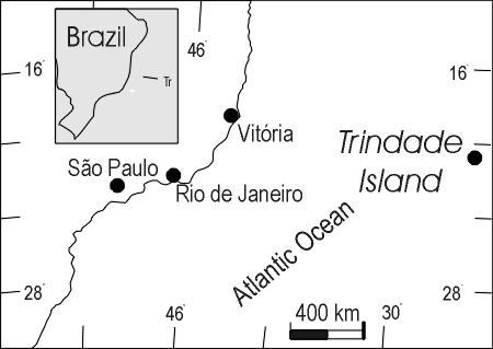
Fig. 1- Situation of the Trindade Island as
related to the Brazilian coast
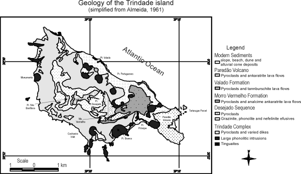
Fig. 2- Simplified geological map, according to
Almeida (1961). M-mountain; Pi-peak: Pr-beach; Pt-point
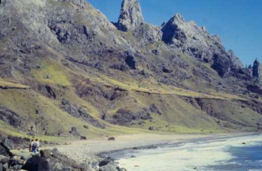
Photo 1 - Aspect of merine terraces of the
Trindade island (Foto Carlos Raposo)
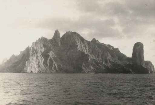
Photo 2 - Aspect of the Trindade Island as seen
from northwest
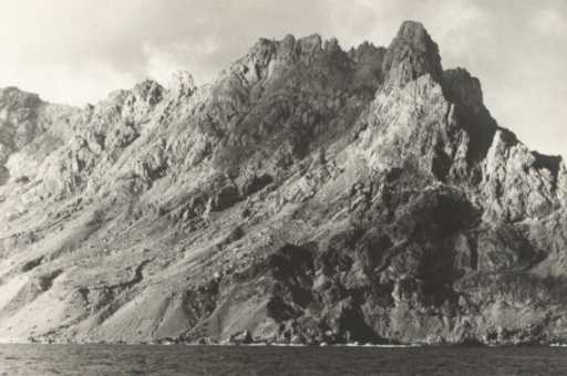
Photo 3 - Northwest extremity of the island. A
thickness of 400 m of rocks belonging to the Trindade Complex are there. A long phonolite
dike supports the Galo Crest
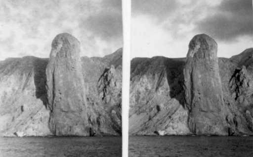
Photo 4 - Stereophotographic pair of the
Monumento, an intrusive phonolitic plug in pyroclastic rocks of the Complex
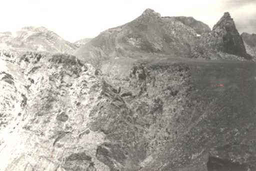
Photo 5 - First plane: the Morro Vermelho
Formation and the Vermelho Creek canyon. Behind them, the axial plateau relief on the
Desejado Sequence rocks
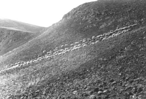
Photo 6 - Slope on ankaratrite of the Vermelho
Creek. It can be noticed the stony soil and savage sheeps
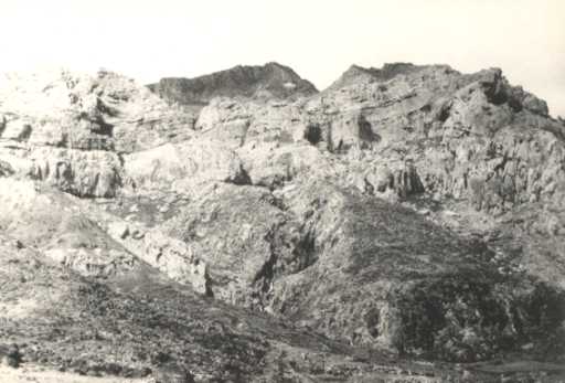
Photo 7 - Scarp behind the Portugueses Beach. At
the lower part pyroclastic rocks are exposed and a large phonolitic intrusion of Trindade
Complex. Above it, scarps of the Desejado Sequence
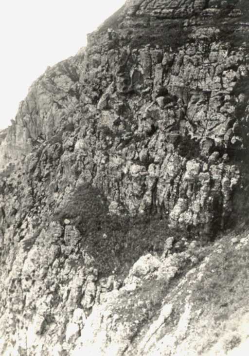
Photo 8 - Scarp on pyroclastic rocks of Trindade
Complex. The two men stand just on the base of Desejado Sequence, which rests in
unconformity on Trindade Complex
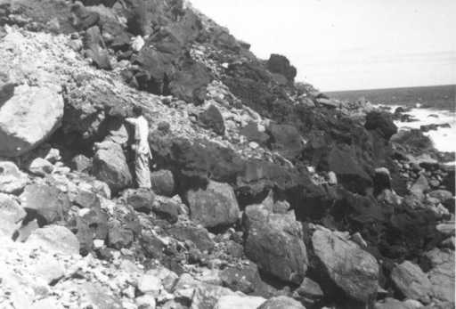
Photo 9 - Two tannbuschitic flows of the Valado
Formation interbedded to blocks of a dejection cone of the Valado Creek which was growing
at that time
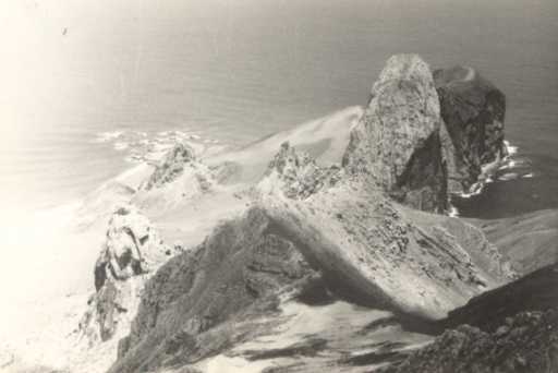
Photo 10 - First plane: lavas and pyroclastic
rocks of the Desejado Sequence move forward the phonolite of the Grazinas Peak. Left,
below, a plateau on lavas of the Morro Vermelho Formation beyond which it can be seen
three large phonolitic intrusions of Trindade Complex. Behind, the ruins of the Paredão
volcano show a part of the circular border of the crater