
SIGEP
Geological and
Paleontological Sites of Brazil - 080
THE FURNAS
STRUCTURAL ESCARPMENT ZONE
IN THE S-SE OF BRAZIL
Date: 19/05/2000
CELIA REGINA DE GOUVEIA
SOUZA
celia@igeologico.sp.gov.br
Instituto
Geológico-SMA. Av. Miguel Stéfano, 3900.
04301-903. Săo Paulo/SP - Brazil.
AGENOR PEREIRA SOUZA
crgs@warp.com.br
Rua Pantaleăo Brás, 40/306-B.
05372-080. Săo Paulo/SP - Brazil.
© Souza,C.R.G.;Souza,A.P. 2000. The Furnas structural escarpment zone in the
S-SE of Brazil. In: Schobbenhaus,C.; Campos,D.A.; Queiroz,E.T.; Winge,M.; Berbert-Born,M. (Edit.) Sítios Geológicos e Paleontológicos do Brasil. Published
19/5/2000 on Internet at the address http://www.unb.br/ig/sigep/sitio080/sitio080english.htm [Actually
https://sigep.eco.br/sitio080/sitio080english.htm]
[SEE
PRINTED CHAPTER IN PORTUGUESE] (The above bibliographic reference of author copy rights is required for any use of this article in any media, being forbidden the use for any commercial purpose)
|
ABSTRACT
The Furnas Structural Escarpment zone is a rare
geomorphological Site in Brazil. It constitutes a group of relict landforms that keeps
important stratigraphic and palaeoenvironmental records. It is an imposing topographical
projection about 5 km wide, which extends along about 260 km between the states of Săo
Paulo and Paraná. The Escarpment has altitudes among 1,110-1,200 m and amplitudes between
100 and 200 m, what has permitted exposing the whole Furnas Formation sequence formed by
Eodevonian sandstones. On the base of the Escarpment is the erosional discordance limiting
the Furnas Formation and the underlain Proterozoic-Eopaleozoic geological units. The
development of the Escarpment zone is related to a series of geodymamic processes started
with the Gondwanaland drift (Jurassic) and followed by differential erosion processes led
under arid to semi-arid and hot climate conditions during the Late Cretaceous to the
Tertiary time. The Site still presents important landforms including ruinform relief,
residual hills (monadnocks), pediments, pinnacles, canyons, falls and rapids. Besides,
there are small caves, grottos and shelters formed into sandstones, which keep
archaeological vestiges.
INTRODUCTION
Structural escarpments are steep slopes terminating high
lands abruptly, which result of lingering and severe action of differential erosion
working on rocks with special geological structures (horizontal or steep bedding, folds,
fractures and even very ancient faults), for hundreds of millions years (Bloom, 1991). In
Brazil those escarpments occur associated to Palaeozoic sedimentary basins and Proterozoic
low-grade metamorphic rocks. In general, they expose different geological formations and
litologies and they do not show uniform topographical expressions. Besides, the majority
had been affected by ruptile tectonic events, being strongly controlled by faults. The
Furnas Structural Escarpment had only been implanted on the Furnas Formation sandstones.
It presents continuous and uniform topographical expression and Mesozoic and Cenozoic
tectonic activities just weakly deformed it.
The Furnas Structural Escarpment zone is located along
the eastern edge of the Paraná Sedimentary Basin, in the states of Săo Paulo and
Paraná. It is a rare Brazilian Geological Site of geomorphological and stratigraphic
natures, still keeping important palaeoenvironmental informations, speleologic features
and archaeological vestiges. It constitutes a well preserved relict landform, whose
genesis started in the Late Mesozoic and led ahead due lingering and continuous
differential erosional processes mainly active under arid and semi-arid climates during
the Tertiary and Early Quaternary. Those geodynamic processes acting on hard sandstones
had been responsible for the development of important landforms including ruinform relief,
canyons, residual hills (monadnocks), pinnacles and pediments. The stratigraphic
significance of the Escarpment is that it has exposed the whole Furnas sequence and the
erosional discordance between this and the underlain Proterozoic and Eopaleozoic
geological units. Small caves and grottos represent speleologic features, which had been
shelters for the prehistoric populations. Nowadays, they still keep important
archaeological vestiges as lithic and ceramic artefacts, rupestrian paintings and human
bones remains.
SITE LOCATION
The Furnas Structural Escarpment zone extends along the
southern portion of the State of Săo Paulo and the oriental side of the State of Paraná,
approximately between 24°00’S to 25°30’S and 49ş00’W to 50°20’W
(Figure 1).
Figure 1.Localisation map of the Furnas
Structural Escarpment and vertical section showing local geomorphological aspects.
The accesses to the Site may be made either by the State
of Săo Paulo, through the cities of Itapeva, Itararé and Bom Sucesso de Itararé, or by
the State of Paraná, throughout by Sengés, Eduardo Xavier da Silveira, Jaguariaíva,
Ventania, Piraí do Sul, Castro, Ponta Grossa, Abapă, Itaiacoca and Campo Largo.
The best views of the Furnas Structural Escarpment zone
are along main and secondary roads and trails that are well known by the local
inhabitants. The most important places are located at the following main roads (Figure 2):
Itapeva-Bom Sucesso de Itararé (Serra da Fazenda Pouso Alto), Itararé-Bom Sucesso
de Itararé (Serra da Ventania), Jaguariaíva-Piraí do Sul (Serra das Furnas),
Ventania-Piraí do Sul (Serra das Furnas), Castro-Ponta Grossa (Serra de Săo
Joaquim) Abapă-Itaiacoca (Serra de Itaiacoca), and Ponta Grossa-Campo Largo (Serra
da Prata).
The most beautiful and important canyons, waterfalls and
rapids which occur along the Escarpment zone are associated to the following main rivers
(Figure 2): Taquari-Guaçu River (SP), Pirituba River (SP), Itararé River (SP/PR),
Jaguaricatu River (PR), Jaguariaíva River (PR), Iapó River (PR) and Pitangui River (PR).
Figure 2. Regional geological context of the
Furnas Structural Escarpment.
HISTORICAL
Derby (1878) was the first author who referred to the
existence of the Escarpment like "an escarpment exposing massive horizontal beds of
white, thick and soft grés, of Devonian age, which is situated in Campos Gerais
area, westward from Curitiba".
The name Furnas was used for the first time by Oliveira
(1912), when he designated the Devonian sandstones exposed at the scarps of the Serra
das Furnas, at Itapeva (SP), and Serrinha, at the western side of Campo Largo (PR).
However, only almost after three decades, Petri (1948) did the formal stratigraphic
denomination applied for the Furnas Formation (Paraná Group), which was later reviewed by
Bigarella et al. (1966).
Maack (1947) denominated of "Devonian Scarp"
the relief associated to the Furnas rocks, whose extends along the edges of the Paraná
Basin. In spite of the term "Devonian Scarp" is frequently found in the
geological and geomorphological literatures, mainly in the State of Paraná, we are
considering that "Devonian" is an inadequate designation to the Escarpment,
because it is related to the age of the Furnas deposition, instead of the age of the
Escarpment, which is younger.
Maack (1968) elaborated a map of the "Devonian
Scarp" in which he included special landforms like mountain ridges and residual hills
associated. He also attributed the scarp origin to erosional processes.
Ab'Saber & Bigarella (1961) assumed the both surfaces
overlaying the top and the base of the scarp in Paraná might be correlated to Purună
Surface (1,190 m high) and Predevonian Surface (950 m high), respectively. For the State
of Săo Paulo, Almeida (1964) associated them to the Japi Surface (Late Tertiary) and
Itapeva Surface (Predevonian age), respectively.
Amongst the most important regional geomorphological
studies concerning the escarpment zone, some authors can be mentioned: Ab'Saber (1964),
IBGE (1968), IPT (1981a), FIBGE (1990a) and Ross (1997).
Countless regional and local geological studies
concerning the Furnas Formation have been accomplished in Paraná and Săo Paulo. Amongst
the ones involving stratigraphic, sedimentological, palaeoenvironmental and tectonic
aspects, they are the most important: Petri (1948), Bigarella et al. (1966),
Bigarella & Salamuni (1967), Lange & Petri (1967), Popp & Barcellos-Popp
(1986), Zalán et al. (1987), Pereira & Bergamaschi (1989), Rodrigues et al.
(1989), Bergamaschi (1992), Assine et al. (1994) and Milani (1997).
SITE DESCRIPTION
As commented previously, the Furnas Structural Escarpment
zone constitutes a special Brazilian landscape and it still keeps important informations
of palaeoenvironmental and stratigraphic nature and speleologic-archaeological records.
The whole those characteristics are described bellow.
Regional landscape
The 260 km long Furnas Structural Escarpment zone extends
from the southern State of Săo Paulo through the oriental side of State of Paraná about
100 km far from Curitiba city. The Escarpment zone is situated between two regional
geomorphological compartments (Figures 1 and 2) denominated Patamares of the
Paraná Basin and Paranapiacaba Mountain Ridge (FIBGE, 1990b). The escarpment line is very
irregular, presenting a festoon standard with several deep amphitheatres cut by rivers
forming canyons. Either ancient faults or joints and basic dikes, whose NS and EW
orientations are transverse to the regional directions of the Escarpment (NE-SW and
NW-SE), in general, control these canyons. This configuration has created an Escarpment
influence zone of about 5 km wide.
The exuberant and continuous topographical expression of
the Furnas Escarpment zone does it easily identifiable in products on several scales,
either on satellite and radar images or on aerial photographs, as well on topographic
maps.
The top altitudes of the Furnas Escarpment are quite
regular and they are always among 1,100 and 1,200 m. The amplitude also varies a little
along, between 100 and 200 m.
The configuration of the Site in plan reminds a parabolic
arch with a pronounced N50W axis (Figures 1 and 2). It results from a basement structural
high of Proterozoic-Eopaleozoic age, which was reactivated and uplifted during the
Mesozoic-Cenozoic times. That structure is well known as Ponta Grossa Arch (Sanford &
Lange, 1960; Zalán et al., 1987a).
Local geomorphological aspects
The Furnas Escarpment zone includes four sectors as are
known: face, base, reverse and front (Figures 1, 3, 4 and 5).
The escarpment face corresponds to vertical steep rocky
slopes that reaches about 120 m high. Along the canyons it is possible to find nice
waterfalls falling down the escarpment face (Figure 6).
The base of the escarpment presents lower steep slopes
dipping 25° to 40°, which are represented by pediments and talus (debris) deposits.
Pediments were developed under arid to semi-arid and hot climates during the Tertiary,
while talus deposits have been formed under more humid conditions of subtropical climate
since the Early Quaternary.
The reverse of the escarpment is represented by a very
smooth surface dipping inland, which has deeply been cut by rivers forming canyons,
countless springs, waterfalls (Figure 6) and rapids.
In front of the escarpment and shared from it there are
several residual hills (monadnocks) and pinnacles. They are constituted by less fractured
silicified sandstones that have been shared from the escarpment face, but they have been
resisting to the whole erosional process. Actually, residual hills and pinnacles are
resultant forms arising from ruinform relief, which always occurs along the escarpment
face and produce odd forms (Figure 5). Severe and lingering differential erosion acting on
stratified sandstones controlled by joints systems have been the most important to the
development of those kind of landforms.
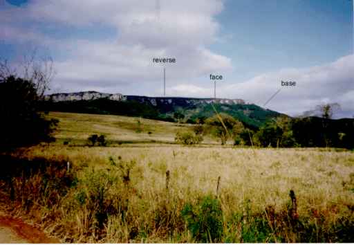
Figura 3.Reverse, face and base of the Furnas Structural
Escarpment.
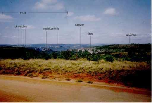
Figure 4. Front of the Furnas Structural Escarpment showing
mainly residual hills (monadnocks) and pinnacles.
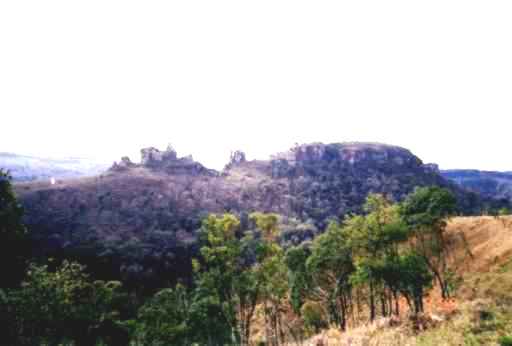
Figure 5. Ruinform relief and odd forms
associated to the Furnas Structural Escarpment.
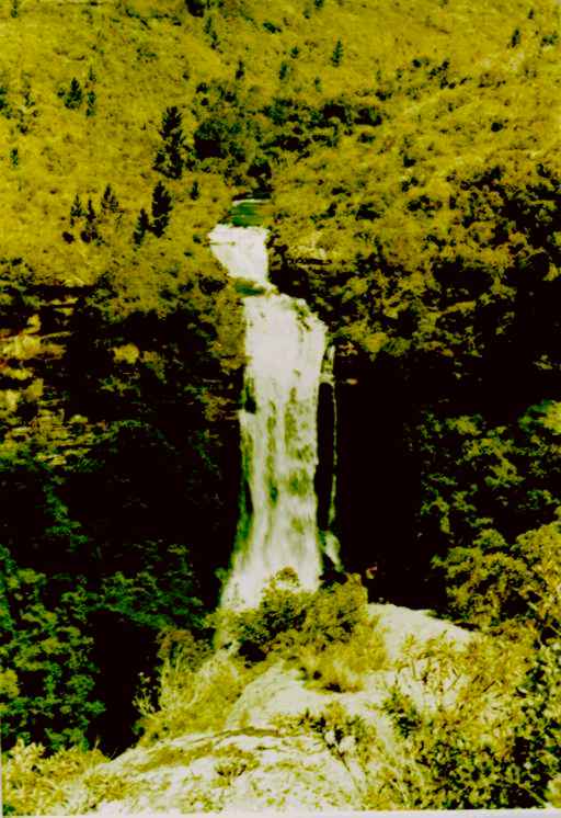
Figure 6. Palmito Mole Fall, Pirituba River
canyon (SP).
Origin, evolution and age
The origin and evolution of the Furnas Structural
Escarpment zone is associated to a series of geodynamic processes which affected the whole
south-southeastern area of Brazil and were initiated with the break-up of the Gondwanaland
(180 to 170 Ma.). The followed processes led by continental basic magmatism (140 to 130
Ma.), marginal uplift and continental drift with marginal coastal basins development and
evolution (120 Ma. up to Recent). Simultaneously, severe and lingering erosional processes
occurred under climate alternations between arid to semi-arid and hot conditions and humid
and hot conditions, which led since the Late Cretaceous and during the Tertiary and Early
Quaternary. Those processes had played a fundamental hole for dissection and
retrogradation of the Escarpment zone. The Escarpment evolution during the Late Quaternary
is mainly associated to the talus deposits development and excavation of the valleys,
under subtropical climate.
The authors have accomplished some studies at Bom Sucesso
de Itararé (SP), concerning a small sedimentary basin sunk into Proterozoic
metasedimentary rocks (Itaiacoca Group), which is far from the Escarpment zone about 7 km.
They have discovered an alluvial fan sequence associated to a braided fluvial system that
was deposited under semi-arid climate, probably during the Miocene, and which its main
sedimentary source was the Furnas Formation (Souza, 1990). That basin was originated under
weak Tertiary ruptile tectonic events. It may be correlated to the sedimentary basins of
the Continental Rift from southeastern Brazil that was described in Riccomini (1989). All
of those facts are important evidences to prove that the Furnas Structural Escarpment has
already constituted an imposing geomorphological feature, at least since the Middle
Tertiary.
Therefore, the Furnas Structural Escarpment constitutes a
relict landform formed mainly during the Late Cretaceous to the Tertiary.
Stratigraphic, palaeoenvironmental and palaeotectonic
characteristics of the Furnas Formation
Furnas Formation presents a flat-lying sandy sedimentary
sequence of Eodevonian age (410 to 390 Ma.), whose the palaeogeographic reconstruction is
possible thanks to the presence of the Escarpment zone.
The Furnas Formation is constituted by whitish sandstones
of coarse to medium grain size, badly to moderately sorted, presenting lenses of medium
and fine sandstones, gravels and conglomerates, and besides pelitic beds with white clay
balls and small lenses. Quartz, feldspars and muscovite are the predominant minerals in
those rocks. Sedimentary structures are abundant and they range of small to large size,
occurring horizontal-parallel lamination, angular to tangential and trough to festoon
cross bedding, current and wave ripple marks and cut-and-fill structures. Sandstones
present groups of concordant and discordant joints, nets of orthogonal joints being
predominant.
Controversies still exist about the depositional site
environment of the Furnas Formation. Some authors suggested marine conditions (Almeida,
1954; Sanford & Lange, 1960; Bigarella et al., 1966; Bigarella & Salamuni,
1967; Lange & Petri, 1967), while others attributed it only to a fluvial environments
(Ludwig & Ramos, 1965; Schneider et al., 1974; Zalán et al., 1987b;
Pereira & Bergamaschi, 1989). On the other hand, the authors have studied a Furnas
sequence outcropping at Itararé-Bom Sucesso de Itararé road, and they have concluded
that those sediments had been deposited in a coastal fluvial system.
The Furnas Formation is discordantly overlying upon five
different geologic units (Figure 2): metasedimentary rocks of the Açungui and Itaiacoca
Groups (Proterozoic), granitoid rocks of the Cunhaporanga and Tręs Córregos Complexes of
Brasiliano age (Late Precambrian), diamictitic rocks of the Iapó Formation (Ordovician to
Silurian), volcanic-sedimentary association rocks of the Castro Group (Ordovician), and
molassic rocks of the Camarinha Formation (Eopaleozoic).
Recent regional studies (Milani, 1997) suggest that the
discordant surface (erosional discordance) over which the Furnas Formation is lain, it was
originated after a great marine regressive episode happened in the Late Ordovician to the
Silurian. So, the Furnas sandy sequence was deposited in a wide golf, which was opened to
southwestward and connected with the Panthalassa Ocean in the southern margin of
the Gondwanaland.
Speleologic features and archaeological vestiges
The grottos and small caves formed into Furnas sandstones
are presented along the whole Escarpment zone. The Barreira Grotto is one of the most
beautiful and interesting examples of sandstone cave, situated at Itararé close to the
limit between the states of Săo Paulo and Paraná.
The most important archaeological and historical vestiges
have already been found in the Site are shelters located into caves and grottos and around
the base of the escarpment, where have been discovered lithic and ceramic artefacts,
rupestrian paintings and human bones remains (Araripe, 1887, apud Araújo, 1995;
Aytai, 1970; Blasi, 1972; Araújo, 1995).
PROTECTION MEASURES
In the State of Paraná, the Furnas Structural Escarpment
zone comprises an Environmental Protection Area (APA) denominated "Devonian Scarp
APA". It encloses an area of about 395,000 ha, including several parks, among them
Vila Velha (Pontes Fo. et al., 1993) and Guartelá (Melo et al.,
in this book).
In the State of Săo Paulo, the Furnas Structural
Escarpment does not constitute an area of environmental preservation or conservation yet.
However, there are six units of environmental conservation in its neighbourhood: Itapeva
Ecological Station, Itaberá Ecological Station, Alto Ribeira-PETAR State Park, Fazenda
Intervales State Park, Xitué Ecological Station and Capăo Bonito National Forest (SMA,
1998).
REFERENCES
Ab’Saber, A.N. 1964. O Relevo Brasileiro e seus Problemas.
In: AZEVEDO, A. (ed.). O Brasil, a Terra e o Homem. Săo Paulo, Ed. Nacional. p.
135-217.
Ab’Saber,A.N.; Bigarella,J.J. 1961. Superfícies
aplainadas do Primeiro Planalto do Paraná. Boletim Paranaense de Geografia, 4/5:
116-125.
Almeida,F.F.M. 1954. Geologia do centro-leste Matogrossense. Boletim
da Divisăo de Geologia e Mineralogia, Rio de Janeiro, DNPM, 150: 1-97.
Almeida, F.F.M. 1964.Fundamentos geológicos do relevo paulista. Boletim
do Instituto Geográfico e Geológico, IGG, Săo Paulo, 41: 169-263.
Araújo,A. G. M. 1995. Levantamento Arqueológico da área
Alto Taquari, Estado de Săo Paulo, com ęnfase na abordagem dos Sítios Líticos.
113p. (Dissertaçăo de Mestrado. F.F.L.C.H. MAE/USP, Săo Paulo).
Assine,M. L.; Soares,P. C.; Milani,E. J. 1994.
Seqüęncias tectono-sedimentares mesopaleozóicas da Bacia do Paraná, sul do Brasil.
Revista Brasileira de Geocięncias, 24 (2): 77-89.
Aytai,D. 1970. As gravaçőes rupestres de Itapeva. Revista da
Universidade Católica de Campinas, 33: 29-61.
Bergamaschi,S. 1992. Análise Sedimentológica da Formaçăo
Furnas na Faixa de Afloramentos do Flanco Norte do Arco Estrutural de Ponta Grossa, Bacia
do Paraná. 172p. (Dissertaçăo de Mestrado. IG-UFRJ, Rio de Janeiro).
Bigarella,J. J.; Salamuni,R. 1967. Some palaegeographhic
features of the Brazilian Devonian. Boletim Paranaense de Geocięncias, 21/22:
133-151.
Bigarella, J. J.; Salamuni, R.; Marques Filho,P. L. 1966.
Estruturas e texturas da Formaçăo Furnas e sua significaçăo paleogeográfica. Boletim
da Universidade Federal Paraná. Geologia, 18, 114p.
Blasi,O. l972. Cultura do índio pré-histórico. Arquivos do
Museu Paranaense. Arqueologia, 6.
Bloom,A. L. 1991. Geomorphology: A Systematic Analysis of Late
Cenozoic Landforms. 2nd edition. 532 p. Prentice-Hall.
Derby, O.A. 1878. Geologia da regiăo diamantífera da Província
do Paraná no Brasil. Museu Nacional., Archivos, v. III, Rio de Janeiro, p.
89-96.
DNPM. DEPARTAMENTO NACIONAL DE PRODUÇĂO MINERAL. 1974. Mapa ao
Milionésimo – Folha Curitiba-Assuncion. Escala 1:1.000.000. Brasília.
DNPM. DEPARTAMENTO NACIONAL DE PRODUÇĂO MINERAL. 1984. Mapa
Geológico do Brasil. Escala 1:2.500.000. Brasília.
FIBGE. FUNDAÇĂO INSTITUTO BRASILEIRO DE GEOGRAFIA E
ESTATÍSTICA. 1990a. Mapa de Unidades de Relevo. Escala 1:5.000.000. Rio de Janeiro.
FIBGE. FUNDAÇĂO INSTITUTO BRASILEIRO DE GEOGRAFIA E
ESTATÍSTICA. 1990b. Geografia do Brasil, Regiăo Sul. Vol. 2, Rio de Janeiro, 419p.
IBGE. INSTITUTO BRASILEIRO DE GEOGRAFIA E ESTATÍSTICA. 1968. Mapa
Geomorfológico do Brasil. Escala 1:5.000.000. Rio de Janeiro.
IPT. INSTITUTO DE PESQUISAS TECNOLÓGICAS. 1981a. Mapa Geológico
do Estado de Săo Paulo. Escala 1:500.000. IPT, Săo Paulo. Vol. I. Programa de
Desenvolvimento de Recursos Minerais, Săo Paulo.
IPT. INSTITUTO DE PESQUISAS TECNOLÓGICAS. 1981b. Mapa
Geomorfológico do Estado de Săo Paulo. Escala 1:500.000. IPT, Săo Paulo. Vol. I.
Programa de Desenvolvimento de Recursos Minerais, Săo Paulo.
Lange,F. W. 1942. Restos de vermiformes no arenito Furnas.
Arquivo do Museu Paranaense, 2:2-18.
Lange,F. W.; Petri,S. 1967. The Devonian on the Paraná
Basin. Boletim Paranaense de Geocięncias, 21/22: 5-55.
Ludwig,G.; Ramos,A.N. 1965. Estudo Faciológico das
Formaçőes Iapó, Furnas e Ponta Grossa, do Paleozóico Inferior da Bacia do Paraná.
PETROBRÁS (Relatório Interno DEBSP/292).
Maack,R. 1947. Breves notícias sobre a Geologia dos Estados do
Paraná e Santa Catarina. Arquivos de Biologia e Tecnologia, vol. II, art.
7, p. 66-154.
Maack, R. 1950. Mapa Fitogeográfico do Estado do Paraná.
Curitiba. Escala 1:750.000.
Maack, R. 1950/1951. Vestígios pré-devonianos de glaciaçăo e a
seqüęncia das Camadas Devonianas do Estado do Paraná. Arquivos de Biologia e
Tecnologia, vol. V/VI, art. 6, Curitiba, p. 197-230.
Maack, R. 1968. Geografia Física do Estado do Paraná.
350p. Curitiba, Badespan/UFPR/IBPT.
Milani,E.J. 1997. Evoluçăo Tectono-Estratigráfica da Bacia
do Paraná e de seu Relacionamento com a Geodinâmica Fanerozóica do Gondwana
Sul-Ocidental. 255p. (Tese de Doutorado. IG-UFRS, Porto Alegre).
MINEROPAR. MINERAIS DO ESTADO DO PARANÁ. 1989. Mapa Geológico do
Estado do Paraná. MINEROPAR, Curitiba. Escala 1:650.000.
Pereira, E.; Bergamaschi, S. 1989. Estudo faciológico dos
sedimentos da Formaçăo Furnas na regiăo de Ponta Grossa (PR), Castro (PR) e Tibagi (PR)
– Bacia do Paraná. In: Simpósio de Geologia do Sudeste, 1. Rio de Janeiro,
1989, SBG. Boletim de
Resumos:1-2.
Petri,S. 1948. Contribuiçăo ao Estudo do Devoniano
Paranaense. Rio de Janeiro. Boletim 129, DNPM/DGM. 125p.
Pontes Filho,A.; Rocha,C.H.; Araki,H. 1993. Identificaçăo de
padrőes da imagem TM Landsat no diagnóstico ambiental da APA da Escarpa Devoniana e de
seu entorno. In: SIMP. BRAS. SENS. REMOTO, VII. Curitiba, 1993. Anais... Curitiba,
INPE. p: 240-244.
Popp,J.H.; Barcellos-Popp,M. 1986. Análise estratigráfica
da seqüęncia deposicional devoniana da Bacia do Paraná (Brasil). Revista Brasileira
de Geocięncias, 16 (2):187-194.
Riccomini,C. 1989. O Rift Continental do Sudeste do Brasil.
256p. (Tese de Doutoramento IG-USP, Săo Paulo).
Rodrigues,M.A.C.; Pereira,E.; Bergamaschi,S. 1989. Ocorręncia
de Psilophytales na Formaçăo Furnas, borda leste da Bacia do Paraná. Boletim
do IG-USP, Pubicaçăo Especial, 7: 35-43.
Ross,J.S. 1997. Mapa Geomorfológico do Estado de Săo Paulo.
Escala 1:500.000. Depto. de Geografia-USP-IPT-FAPESP. Săo Paulo.
Sanford,R.M.; Lange,F.W. 1960 Basin study approach to oil
evaluation of Paraná miogeosyncline, South Brasil. Bulletim of American Association of
Petrolleum Geologist, 44 (8): 1316-1370.
Schneider,R.L.; Mulmann,H.; Tommasi,E.; Medeiros,R.A.;
Daemon,R.F.; Nogueira,A.A. 1974. Revisăo Estratigráfica da Bacia do Paraná. In:
Congresso Brasileiro de Geologia, 28. Porto Alegre, 1974, SBG. Anais,1:41-65.
SMA. SECRETARIA DE MEIO AMBIENTE DO ESTADO DE SĂO PAULO. 1998. Atlas
das Unidades de Conservaçăo Ambiental do Estado de Săo Paulo – Parte II: Interior.
SMA, Săo Paulo.
Souza,A. P. 1990. Mapa Geológico na Escala 1:50.000 e Esboço
da Evoluçăo Tectônica e Sedimentar do Grupo Itaiacoca, nas Folhas Barra do Chapéu e
Ouro Verde – SP/PR. 200 p. (Dissertaçăo de Mestrado, IG-USP, Săo Paulo).
Zalan,P.V; Wolff,S.; Conceiçăo,J.C.J.; Astolfi,M.A.;
Vieira,I.S.; Appi,V.T.; Zanotto,O.A. 1987a. Tectônica e sedimentaçăo da Bacia do
Paraná. In: SIMPÓSIO SUL-BRASILEIRO DE GEOLOGIA, 4ş. Curitiba, 1987. Atas...
Curitiba, SBG. v. 1, p. 441-477.
Zalan, P.V; Wolff, S.; Conceiçăo, J.C.J.; Astolfi, M.A.;
Vieira,
I.S.; Appi, V.T.; Zanotto, O.A. 1987b. A divisăo tripartite do Siluriano da Bacia do
Paraná. Revista Brasileira de Geocięncias, 17 (3): 242-252.