
SIGEP
Geological and Paleontological
Sites of Brazil - 079
Ichnosite of Ouro
- Araraquara,
Sćo Paulo state, Brazil
Date: 07/10/1999
Giuseppe Leonardi
g.leonardi@iol.it
Via A. Modigliani, Monterusciello
80070 Pozzuoli - Na - Italia
Ismar de Souza Carvalho
ismar@igeo.ufrj.br
Universidade Federal do Rio de Janeiro
Instituto de Geociźncias - CCMN - Depto de Geologia
21949-900 Cidade Universitįria - Ilha do Fundćo -
Rio de Janeiro-RJ - Brasil
© Leonardi,G.; Carvalho,I.S. 1999. Ichnosite of Ouro - Araraquara, Sćo Paulo state, Brazil. In: Schobbenhaus,C.; Campos,D.A.; Queiroz,E.T.; Winge,M.; Berbert-Born,M. (Edit.) Sķtios Geológicos e Paleontológicos do Brasil. Published
7/10/1999 on Internet at the address http://www.unb.br/ig/sigep/sitio079/sitio079english.htm [Actually
https://sigep.eco.br/sitio079/sitio079english.htm]
[SEE
PRINTED CHAPTER IN PORTUGUESE]
(The above bibliographic reference of author copy rights is required for any use of this article in any media, being forbidden the use for any commercial purpose)
|
Abstract
The ichnosite of Ouro (Araraquara, Sćo Paulo State) is one of the
richests tetrapod ichnologic area of Jurassic age in South America. The ichnofossils are
found in eolian sandstones, reddish colored in lithofacies considered to be dune and
interdune deposits. These sandstones are named as Botucatu Formation, and originally
covered a surface estimated in at least 1,300,000 km2, constituting the largest
known fossil desert in the world.
The tetrapod tracks from the Ouro quarries comprise bipedal
dinosauroids of relatively large and smaller types; theromorphoid and mammaloid forms.
This ichnofauna seems to be completely endemic and, therefore, quite new to science. Also
occur invertebrate trace fossils produced by insects and earthworms.
Seventheen ichnosites analogous to that of Ouro site have been
discovered along the strip of nearly 2,500 km where the Botucatu Formation sandstones
outcrops at Paranį Basin. A complete and detailed study of this ichnofauna is in its
initial phase.
Resumo
O jazigo icnofossilķfero do Ouro (Araraquara, Estado de Sćo Paulo)
uma das mais ricas regiões icnológicas do Jurįssico da América do Sul. Os icnofósseis
sćo encontrados em arenitos eólicos avermelhados, em litofįcies consideradas como
depósitos de dunas e interdunas. Estes arenitos sćo designados como Formaēćo Botucatu,
e originalmente recobriam uma superfķcie estimada em pelo menos 1.300.000 km2,
constituindo o maior deserto jį existente na superfķcie da Terra.
As pistas de tetrįpodes das pedreiras da regićo do Ouro compreendem
formas dinossauróides bķpedes, além de formas teromorfóides e mamaliformes. Esta
icnofauna parece ser completamente endźmica. Também ocorrem icnofósseis de
invertebrados que sćo interpretados como pistas e escavaēões de insetos e anelķdeos.
Dezessete sķtios icnofossilķferos anįlogos ą localidade do Ouro
tźm sido descobertos ao longo de uma faixa de 2.500 km em afloramentos da Formaēćo
Botucatu, Bacia do Paranį. O estudo detalhado desta importante icnofauna encontra-se
apenas em sua fase inicial.
1. Introduction
The tetrapod ichnological site of Ouro is situated in the State of Sćo
Paulo, in the Municipality of Araraquara, 4 kilometers E of the Ouro railway station on
the railway line from Sćo Carlos to Araraquara, approximately 8 km ESE from the center of
the town of Araraquara. There were there several quarries: Sćo Bento - Corpedras (code:
ARSB); Califórnia (ARCA); Cerrito Velho (ARCE); Cerrito Novo (ARCN); Santa Įgueda
(ARSA); Chibarro (ARCH). Presently only the Sćo Bento - Corpedras quarry is open. The
sandstones are quarried and used as a source of building material, particularly as
flagstones for paving of sidewalks and for facing walls and pillars. The coordinates of
the site (mean) are 21o49'S; 48o05'W.
The sandstones that present the tetrapod footprints are named as
Botucatu Formation. This lithostratigraphic unit embodies Mesozoic eolian sandstones that
extends along a stretch of Brazilian territory comprised between the states of Minas
Gerais and Rio Grande do Sul, appearing also in the states of Mato Grosso and Goiįs, on
the west border of Paranį Basin (Figure 1).
The Botucatu Formation lithofacies are considered to be the dune
(foreset and interdune facies) deposits. These are interpreted as great dunes climbing, in
an inland
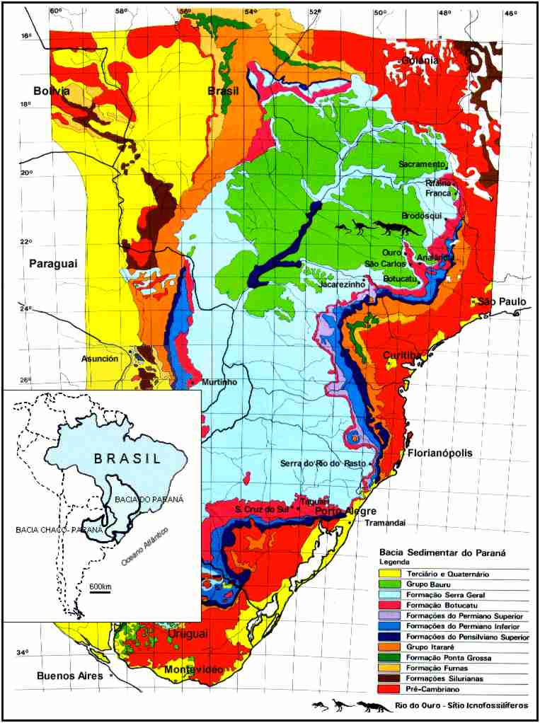
Figure 1 - Geological map of Paranį Basin and distribution area of
Botucatu Formation ( modified from Mapa Geológico da Bacia do Paranį, 1981 ).
desert with high sand supply. In this way there was the construction of
an erg, that overpass the freatic level changes, allowing that the interdunes areas keep
always dry (Caetano-Chang, 1997). Despite this environmental condition of the Botucatu
desert, some small lakes should have existed, especially in areas where the tetrapod
ichnofauna is abundant.
2. Geology
The Botucatu Formation comprises Mesozoic aeolian sandstones, reddish
colored, that originally covered a surface estimated in at least 1,300,000 km2,
constituting the largest known fossil desert in the world. From the paleontological point
of view, the sandstones in the Botucatu Formation are void of body fossils, which have
been interpreted as a consequence of the desert environment.
The age of these deposits have been traditionally considered as
belonging to the Triassic. Therefore, Leonardi & Oliveira (1990) recognized that the
date is not known with any precision. The reason for this is the environment: it
represents a hot, dry, continental interior desert, where body fossils of animals and
plants do not occur, nor pollens. There is only radiometric dating (120 - 140 Ma) on the
flood basalts of the Serra Geral Formation that capped the Botucatu Formation. The
ichnological analysis presented by Leonardi & Oliveira (1990) postulated that the
Botucatu Formation, at least in outcrops of Sćo Paulo State, and particularly in the
Araraquara area could be considered between the Rhaetian and Middle Jurassic, with greater
probability for the Lower Jurassic or the lower most section of Middle Jurassic.
3. History of the Site
In 1911, the Brazilian mining engineer Joviano Pacheco discovered the
first slab from the Botucatu Formation with a tetrapod trackway, as a flagstone in a
sidewalk in the town of Sćo Carlos, 39 km SW of Araraquara, where very probably it
originated. The original flagstone was deposited by Pacheco, along with some slabs with
invertebrate trails, in the Geographic and Geological Commission Museum of Sćo Paulo,
presently called the Geological Institute of Sćo Paulo, and appears to be the first
tetrapod trackway discovered and collected in South America. However, it was only much
later published by Friedrich von Huene (1931).
Shortly after arriving in Brasil, Leonardi started inquiries about the
origin of the Pacheco's flagstone and discovered in July 1976 in the municipality of
Araraquara, region of Ouro, an abundant and varied ichnofauna consisting mainly of
vertebrate tracks and secundarily invertebrate trails, in the above said quarries, then
actively worked, as well as in the sidewalks of the town of Araraquara (Leonardi, 1980).
These findings have both ichnological and petrographic characteristics similar to those of
the Geological Institute flagstone. Other Leonardi's expeditions followed (11 altogether,
cfr. Leonardi, 1994, p. 169), by means of grants from the CNPq (The Nacional Council for
Research of Brazil). Between 1976 and 1986 natural exposures, quarries and town pavements
throughout the eastern outcrop of the Botucatu Formation, from Minas Gerais (North) to Rio
Grande do Sul (South) was explored by Leonardi and collaborators, especial attention being
paid to those of the Sćo Paulo State. The recovery of fossils was startling: vertebrate
tracks were discovered in five Brazilian states, at Sacramento (Minas Gerais), Rifaina,
Franca, Brodósqui, Analāndia, Araraquara, Sćo Carlos and Botucatu (Sćo Paulo);
Jacarezinho (Paranį), Serra do Rio do Rasto (Santa Catarina), Taquari, Tramandaķ and
Santa Cruz do Sul (Rio Grande do Sul) a belt 2500 km long (Leonardi, 1977; 1981a-b; 1989;
Leonardi & Sarjeant, 1986; Leonardi & Godoy, 1980). Later, two sites were
discovered by Leonardi in the western side of the Paranį basin, in Murtinho (Mato Grosso)
and Asunción (Paraguay) (Leonardi, 1992, 1994).
From the first visit in 1976, it was realized that the most important
track bearing outcrop of the Botucatu Formation was not in any quarry or natural exposure,
but in the streets of Araraquara. This is an agricultural and industrial city situated
near the geographical center of the state of Sćo Paulo. Here there are over 300 linear
kilometers of sidewalks, courtyard paving and other pedestrian ways, all made from
flagstones of pink or red sandstone. Such is the frequency of tetrapod tracks that any
average stretch of flags, 100 metres long (a mean block) by 2.5 metres wide can be
expected to contain between five and ten trackways or isolated footprints all in all, an
enormous bonanza for the paleoichnologists! Whilst any paleontologist would, of course,
prefer to find his fossils in situ, the fact that all those flagstones came from a
restricted area of outcrop means that their source is known with sufficient accuracy for
most practical purpose. Indeed, all the quarries from which the flagstones were procured
(with the exception of the Chibarro quarry) are within an area of only 0.75 km2.
In many instances, the precise colour and consistency of the slab and the nature of its
sedimentary structures enable the very horizon from which it came to be identified with
confidence (Leonardi & Sarjeant, 1986).
Between 1976 and 1983, all the sidewalks and other pavements - an
extent of 308 km, or 0.77 km2 - were surveyed by Leonardi, in one expedition
being aided by a group of students from the School of Geology of the Federal University of
Paranį at Curitiba. Some thousands of tracks were recorded, many of them were filed,
photographed, measured, and sketched. Of these, some sixty trackways or isolated
footprints were of such quality as to merit special attention. After two unsuccessful
attempts to convince two successive mayors of Araraquara that these slabs were of
scientific importance, the chosen sixty flagstones were successfully collected and
substituted with the permission and the logistic assistence of the City Council in 1983,
in a rare urban palaeoichnology exploit (Ibidem). In the meanwhile, the continuation of
the stope on the working faces of the Sćo Bento quarry of the Corpedras firm was
periodically assisted by Leonardi. Altogether, more than 200 slabs exhibiting tetrapod
footprints have been collected from the urban sidewalks as well as from the quarries, for
lodgement either in the Museu Nacional at Rio de Janeiro (Federal University of Rio de
Janeiro), palaeontological collection of the Departamento Nacional da Produēćo Mineral
at Rio de Janeiro (Ibidem) and Federal University of Paranį (Curitiba).
Many flagstones with tetrapod tracks produced almost certainly from the
Ouro ichnosites were found in the urban pavements of other towns within the Sćo Paulo
state, including the capital of Sćo Paulo, e.g. in the pavements outside the airport of
Congonhas and the Zoo.
Nowadays there is a continuous prospection and collection of new slabs
that have been lodged at Universidade Estadual Paulista (UNESP - Rio Claro) and Rio de
Janeiro Federal University (Geology Department).
- The Ichnofauna of the Ouro Ichnosite
The tetrapod tracks from the Ouro quarries (and from the sidewalks of
the town) are almost always (90-95%) of poor quality, the footprints being simply a
rounded or elliptical cavity (convexity in the counterprints or natural casts) furnishing
no morphological details. Characteristically this cavity is accompanied by a crescentic
sandstone ridge, always in the direction of foreset dip, representing the sand displaced
by the animal's foot during its progression across the slopes of a dune. However, the
parameters of such tracks frequently enable them to be classified, despite their poor
quality, provided that a good specimen of the same type has been found also. Firm
identifications and descriptions depend necessarily on the better specimens, and it is on
the basis of these, in the last analysis, that the comments below are made (Ibidem).
The classification is always difficult due to the poor quality of the
material and due to the uncertainty as to the age of the formation, because of lack of
associated body fossils and because of the endemicity of the ichnofauna.
Presently it appears that the ichnofauna of Ouro covers (Figure 2,3).
a) Eight dinosauroid forms, all bipedal, digitigrade and tridactylous,
with an elevated pace angulation (up to 180o). These tracks are relatively
rare. This group includes two or three types of relatively large dinosaurs (within this
dwarf desert fauna), with footprints 12 cm long and strides up to 2 meters; some
medium-sized animals, with a stride of 1-1.5 metres; and some smaller types. One small
form is trydactylous but frequently appears monodactylous in the running gait.
b) At least seven theromorphoid forms that are rarely encountered in
the sidewalks and very rarely found in the quarries. It is difficult to recognize the
parameters of the trackways (stride, pace, pace angulation etc.) because they are
represented mainly by isolated footprints. By the morphology of the footprints, they are
attributable to highly specialized quadrupedal animals, with advanced gait. The footprints
are plantigrade and their outline points to rounded or elliptical paws, with the
transverse axis larger than the antero-posterior. The digits are always very short,
pointing to a probable phalangeal formula 2-3-3-3-3 (osteologic or functional). The claws
are partially or completely separated from the palm or sole and are sometimes modified
into small hooves. The stride is between 15 and 50 cm. The trackway is relatively narrow
for a quadrupedal animal and the pace angulation is up to 160o.
c) At least nine forms, because of their advanced gait, the shape of
their autopodia (rounded or elliptical paws, with the transverse axis larger than the
antero-posterior, the digits always very short, pointing to a probable phalangeal formula
2-3-3-3-3) and because of their small dimensions can be morphologically defined as
mammaloid. Almost all of these forms appears to be new; some at the ichnogenus level,
others at the morphofamily level. This group includes some rare and interesting trackways
with hopping and gallopping gaits. Among these tracks, the most abundant form was
classified Brasilichnium elusivum Leonardi, 1981. This form has a strong
heteropody, with the forefeet extremely small.
d) Height to ten forms of invertebrate trails, mainly attributable to
arthropods. The invertebrate trails are remarkably rarer than the tetrapod tracks.
The statistical composition of the Ouro icnhnofauna, in a sample of the
first 100 collected slabs, is as follows: it includes a small number of therapsid
individuals but a large
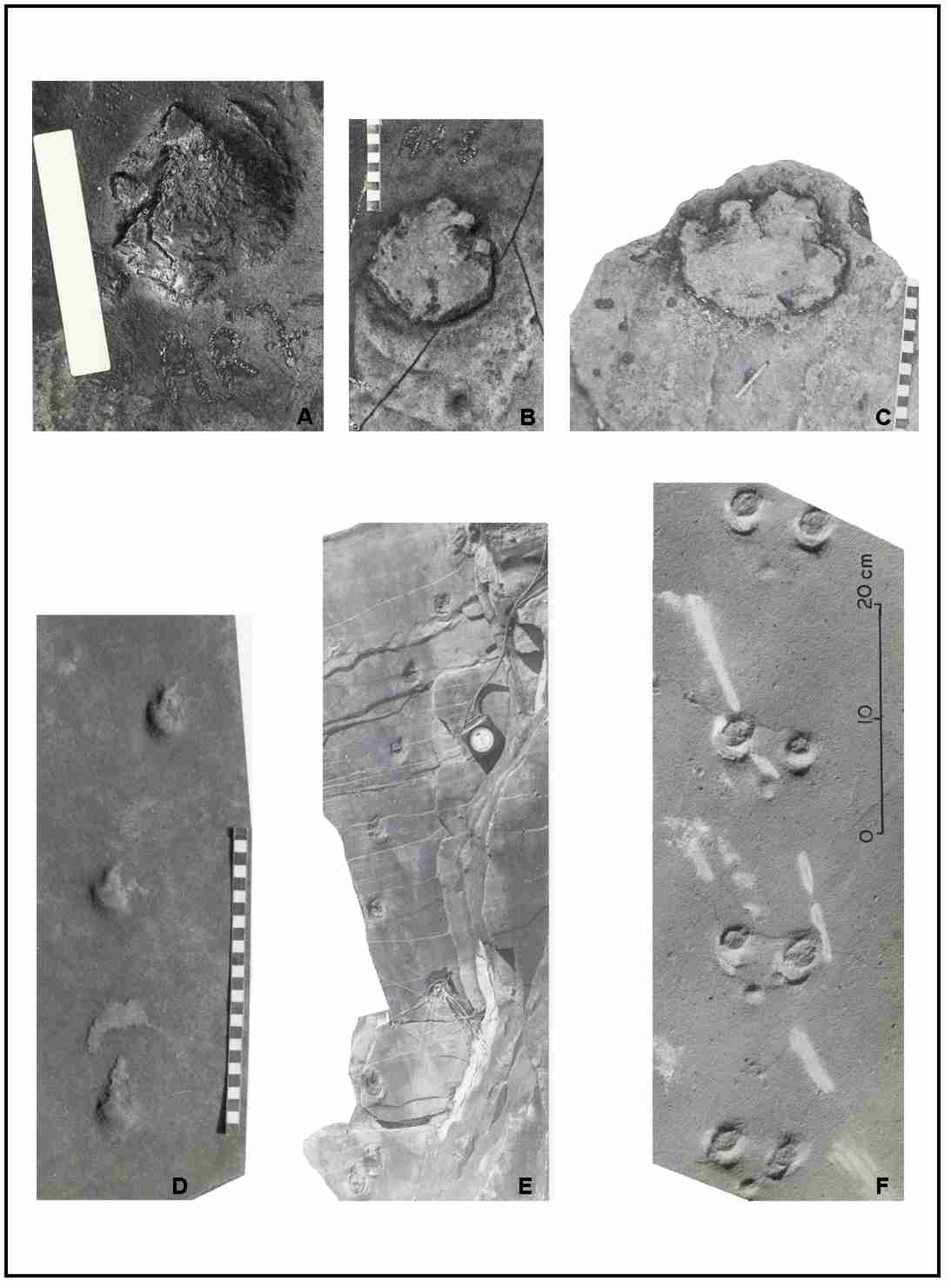
Figure 2 - Fossil footprints from Botucatu Formation. (A),(B),(C)
Theromorphoid footprints attributed to ? Tritylodontoidea Flagstones from the sidewalks of
Araraquara; (D),(E) Small theropod trackway ( ? coelurosaur ) collected from the sidewalks
of Araraquara (D) and (E) Cerrito Velho Quarry, Araraquara; (F) Mammaloid trackway with
galloping gait. Sćo Bento Quarry, Araraquara.
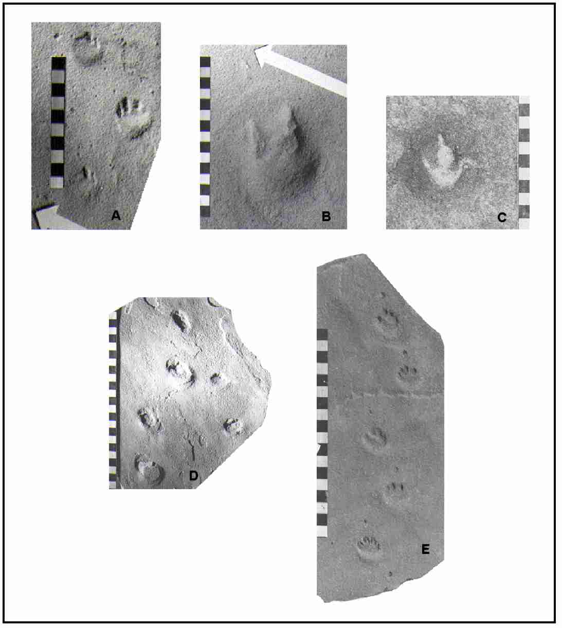
Figure 3 - Fossil footprints from Botucatu Formation. (A) Probable
theromorphoid track ( ? Tritylodontoidea ) from Sćo Bento Quarry, Araraquara; (B) ?
Coelurosauria footprint, Cerrito Novo Quarry, Araraquara; (C) Bipedal dinosaur track.
Flagstone from the sidewalks of Araraquara; (D), (E) Brasilichnium elusivum
trackways referred to early mammals. (D) Sćo Bento Quarry, Araraquara; (F) Flagstone from
the sidewalks of Araraquara.
number of forms ( 7.7% of the individuals and 29.2% of the forms ); a
good percentual of dinosauroid tracks as for the individuals (27,9%) and the forms
(33.3%); the mammal percent is high as for the individuals (64.4%), not so for the forms
(37.5%). Sixty three tracks and 14 forms are quadrupedal; 41 tracks and 10 forms are
bipedal. In this ichnofauna, where a number of mammaloid tracks present bipedal hopping
gait, bipedalism is rather common (39.4% of the individuals and 41,7% of the forms). The
sprawling tracks are completely absent. The therapsidian/archosaurian ratio is 0.28; the
mammalian/archosaurian ratio is 2.31; the theropsidian = (therapsids +
mammals)/archosaurian ratio is 2,58. These results are significant; however, they were
probably biased in the picking up of the slabs, in favour of the dinosauroid and
theromorphoid tracks.
The trackwakers, at Ouro site and especially at the Sćo Bento quarry,
preferred certain directions. Indeed, 76% of the trackways examined in situ are
oriented in both ways to directions within the 2nd and 4th quadrants of the compass. As a
whole, the animals have crossed most frequently (and diagonally) a large transverse dune.
The motives that explain this special direction are not known at present. One could
express the working hypothesis that this direction could correspond to a track connecting
two watering points or oases.
The ichnofauna seems to be completely endemic. This factor causes
problems in the classification and interpretation of the tracks, but adds greatly to their
interest. As noted earlier, this was a very arid environment, a desert and/or semi-desert
highland and it is known that arid and highland environment ichofaunas and faunas are
relatively rare. Unfortunately, a complete and detailed study of this ichnofauna was not
so far issued.
5. The Trackmakers
We start from the presumption that the Botucatu Formation be Lower
Jurassic, as it seems more probable from the ichnological point of view (Leonardi &
Lima, 1990). If this is the correct datation, then the small and medium dinosauroid tracks
with clawed digits may most probably be attributed to ceratosaurid theropods and the
largest dinosauroid tracks, sometimes with hoofed digits, to the ornithopods. The
theromorphoid tracks are attributed to therapsids and, in the Liassic hypothesis, to the
Tritylodontoidea, the only group of therapsids present after the end of the Triassic. The
mammaloid forms probably belong to true early mammals.
6. Other Ichnosites of the Botucatu Formation
A number of ichnosites analogous to that of Ouro site were discovered
by Leonardi, along the strip of nearly 2,500 km where the Botucatu Formation sandstones
outcrop along the eastern side of the Paranį Basin and more rarely along the western
side. The sites are the following, clockwise:
Eastern side:
a) Sacramento (Minas Gerais) - flagstones of some sidewalks;
undetermined tetrapods.
b) Frutal (Minas Gerais) - flagstones of some sidewalks; undetermined
tetrapods.
c) Rifaina (Sćo Paulo) - flagstones of some sidewalks; isolated
footprints and trackways of the theromorphoid and coelurosauroid kind.
d) Franca (Sćo Paulo) - flagstones of some sidewalks; isolated
footprints and trackways of the theromorphoid and coelurosauroid kind on the flagstones of
some sidewalks; these probably proceed from the Brodósqui quarries.
e) Brodósqui (Sćo Paulo) - isolated footprints and trackways of the
theromorphoid and coelurosauroid kind.
f) Sćo Carlos (Sćo Paulo) - in a quarry, a short trackway attributed
to a mammal or to a theriodont. Tracks on flagstones of some sidewalks and on the facing
of the cathedral pillars. These probably proceed from Araraquara quarries.
g) Analāndia (Sćo Paulo) - some trackways of the mammaloid kind, one
of them with the ricochet gait.
h) Rio Claro (Sćo Paulo) - flagstones of some sidewalks; undetermined
tetrapods.
i) Botucatu range (Sćo Paulo) - two isolated footprints, relatively
large size, perhaps attributable to ornithopods.
j) Jacarezinho (Paranį) - tracks of undetermined tetrapods on
flagstones found in other Paranį towns were procured in quarries near this town.
k) Ponta Grossa and Curitiba (Paranį) - flagstones of some sidewalks;
undetermined tetrapods. The flagstones probably come from the Jacarezinho quarries.
l) Serra do Rio do Rasto (Santa Catarina) - record of a tetrapod
trackway, not seen.
m) Taquari (Rio Grande do Sul) - record of tetrapod trackways, not
seen.
n) Santa Cruz do Sul (Rio Grande do Sul)- a flagstone with two parallel
trackways, one of a small theropod, the other of Brasilichnium elusivum.
o) Tramandaķ (Rio Grande do Sul) - one theropod isolated track, on a
flagstone in the town sidewalks.
Western side:
a) Assunción (Paraguay) - flagstones of some sidewalks; theropods and
tritylodonts; Missiones Formation, probably Lower Jurassic.
b) Murtinho (Mato Grosso do Sul) - flagstones of the platforms of the
railway station; undetermined tetrapods.
7. Invertebrate Tracks
The first description of invertebrate trace fossils was presented by
Pacheco (1913) that recognized "worm tunnels" in the sandstones of Botucatu
Formation. Later, Almeida (1954), Bjornberg & Tolentino (1959) also identified new
"worm trails" in threse sandstones. Paraguassu (1970) proposed that these
ichnofossils were produced by conchostraceans. Leonardi (1980, 1984), Leonardi & Godoy
(1980) and Leonardi & Sarjeant (1986) considered them as "worm" and
arthropod tracks.
The following localites with invertebrate ichnofossils in Botucatu
Formation was presented by Fernandes et alii (1990):
a) Quarry 3 - 4 km from Sćo Carlos (Sćo Paulo) - worm tunnels
(Pacheco, 1913).
b) Botucatu Range (Sćo Paulo) - worm tunnels (Almeida, 1950).
c) Pacaembu, Sćo Carlos (Sćo Paulo) - worm trails (Bjornberg &
Tolentino, 1959).
d) Quarry of Sćo Tomįs Farm, Ibaeté county (Sćo Paulo) -
conchostraceans trails (Paraguassu, 1970).
e) Quarries of Araraquara (Sćo Paulo) - worm trails and arthropod
tracks (Leonardi, 1980).
f) Sćo Bento Quarry, Araraquara (Sćo Paulo) - arthropod trails
(Leonardi, 1984).
g) Sćo Bento Quarry, Araraquara (Sćo Paulo) - trails and invertebrate
burrows (Leonardi & Godoy, 1980).
h) Quarry of Itaguaēu Farm, Sćo Carlos (Sćo Paulo) - worm trails
(Leonardi & Godoy, 1980).
The study presented by Fernandes et alii (1990) classified the
trace fossils of Botucatu Formation as Taenidium satanassi D’Alessandro
& Bromley, 1987 and Taenidium serpentinum Heer, 1897, besides
"U" shaped burrows. Ethological interpretation of Taenidium trails
attributes them as feeding traces, whose burrow fills could be considered as faecal
material or the packets of surrounding sediments by earthworms and insects; the
"U" - shaped burrows are probably evidence of insect or earthworms dwelling
tubes.
8. Protection
The tetrapod ichnofossils from Ouro site have been collected and housed
in Museums and Universities of Paranį, Sćo Paulo and Rio de Janeiro states. There is any
kind of protection in the quarry were these material are found. Generally the more
conspicuous tracks are selected by the workers of the Corpedras (Ouro Site) and then
foward to universities.
The flagstones with ichnofossils from the sidewalks of Sćo Carlos
(Sćo Paulo State) have been filed by Marconoto & Bertini (1999) aiming the
educational use of this material integrated in the daily of the Sćo Carlos citizens. The
sidewalks with fossil footprints are an open museum, that can be used in the future in
regional tourism projects.
9. Acknowledgments
Mr. Tim Halley of the Zoology Department of the Queensland University
Brisbane (Austrįlia) for its critical review. Professor Maria Rita Caetano-Chang
(Universidade Estadual Paulista - UNESP/Rio Claro) for her collaboration with the
bibliographic material. The family Grosso (CORPEDRAS) for the collaboration.
This study was support by Conselho Nacional de Desenvolvimento
Cientķfico e Tecnológico (CNPq), Fundaēćo de Amparo ą Pesquisa do Estado do Rio de
Janeiro (FAPERJ) and Fundaēćo Universitįria José Bonifįcio (FUJB/UFRJ).
10. References
ALMEIDA, F.F.M. 1954. Botucatu, um deserto triįssico da
América do Sul. Rio de Janeiro, DNPM/DGM, Notas Preliminares e Estudos, no
86, 21 p.
BJORNBERG, A.J.S. & TOLENTINO, M. 1959. Contribuiēćo ao estudo da
geologia e įguas subterrāneas em Sćo Carlos, SP. Bol. Soc. Bras. Geol., 8(2):
5-33.
CAETANO-CHANG, M.R. 1997. A Formaēćo Pirambóia no Centro-Leste do
Estado de Sćo Paulo. Tese de Livre-Docźncia (Instituto de Geociźncias e Ciźncias
Exatas), UNESP, Rio Claro-SP, 196 p., 41 figs., 64 fotogr., 7 tab.
FERNANDES, A.C.S.; CARVALHO, I.S. & NETTO, R.G. 1990. Icnofósseis
de invertebrados da Formaēćo Botucatu, Sćo Paulo (Brasil). Anais da Academia
brasileira de Ciźncias, 62(1): 45-49.
Huene, F. 1931. Verschiedene mesozoische Wierbeltierreste aus
Südamerika. Neuen Jahrbuch für Mineralogie, Geologie, Paläontologie, Beil-Bd. 66(B):
181-198, 21 figs.
Leonardi, G. 1977. On a new occurrence of Tetrapod trackways in the
Botucatu Formation in the State of Sćo Paulo, Brazil. Dusenia, Curitiba, 10(3): 181-183,
3 figs.
LEONARDI, G. 1980. On the discovery of an ichno-fauna (vertebrates and
invertebrates) in the Botucatu Formation s.s. in Araraquara, Sćo Paulo, Brazil. Anais
da Academia brasileira de Ciźncias, 52(3): 559-567.
Leonardi, G. 1981a. As localidades com rastros fósseis de Tetrįpodes
na América Latina. Anais do 2o Congresso Latino-Americano de
Paleontologia, Porto Alegre, 1981, 2: 929-940, 1 fig. Porto Alegre.
Leonardi, G. 1981b. Novo Ichnogźnero de Tetrįpode Mesozóico da
Formaēćo Botucatu, Araraquara, SP. Anais da Academia brasileira de Ciźncias, 53(4):
793-805.
LEONARDI, G. 1984. Rastros de um mundo perdido. Ciźncia Hoje,
SBPC, 2(15): 48-60.
Leonardi, G. 1989. Inventory and Statistics of the South American
Dinosaurian Ichnofauna and its Paleobiological Interpretation. In: Gillette, D.D. &
M.G. Lockley (eds). Dinosaur Tracks and Traces. Cambridge, Cambridge University Press,
1989. 454 p., illustr.: 165-178, 4 plates.
Leonardi, G. 1992. Sulle prime impronte fossili del Paraguay.
Paleocronache, 1992(1): 66-67. Milano.
Leonardi, G. 1994. Annotated Atlas of South America Tetrapod Footprints
(Devonian to Holocene) with an appendix on México and Central America. Brasķlia, CPRM,
1994. 248 p., 35 plates, 27 figs., tabs.
LEONARDI, G. & GODOY, L.D. 1980. Novas pistas de tetrįpodes da
Formaēćo Botucatu no Estado de Sćo Paulo. In: Congr. Bras. Geol., 31, Camboriś, 1980. Anais...
Camboriś, SBG, v. 5, p. 3080-3089.
Leonardi, G. & Lima, F.H. de O. 1990. A revision of the Triassic
and Jurassic tetrapod footprints of Argentina and a new approach on the age and meaning of
the Botucatu Formation footprints (Brazil). Revista Brasileira de Geociźncias, 20(1-4):
216-229.
Leonardi, G.; Oliveira,F.H. 1990. A revision of the Triassic
and Jurassic tetrapod footprints of Argentina and a new approach on the age and
meaning of the Botucatu Formation footprints (Brazil). Revista Brasileira de
Geociźncias, 20(1-4):216-229.
LEONARDI, G. & SARJEANT, W.A.S. 1986. Footprints representing a new
mesozoic vertebrate fauna from Brazil. Modern Geology, 10: 73-84.
MARCONATO, L.P. & BERTINI, R.J. 1999. Avaliaēćo preliminar do
panorama icnofossilķfero nas vias pśblicas da Cidade de Sćo Carlos, SP. Potenciais
cientķfico, cultural e didįtico. In: CONGRESSO BRASILEIRO DE PALEONTOLOGIA, 16, Boletim
de Resumos... Crato, 1999, p. 65.
PACHECO, J.A.A. 1913. Notas sobre a geologia do Valle do Rio Grande a
patir da fóz do Rio Pardo até a sua confluencia com o Rio Parahyba. In: Comissćo
Geographica e Geologica do Estado de Sćo Paulo. Exploraēćo do Rio Grande e de seus
afluentes. Sćo José dos Dourados, Sćo Paulo, p. 33-38.
PARAGUASSU, A.B. 1970. Estruturas sedimentares da Formaēćo Botucatu,
Rio de Janeiro. Min. Met., 51(301): 25-30.
PAULIPETRO. 1981.MAPA GEOLÓGICO DA BACIA DO PARANĮ. In: Relatório de
Atividades 1979/1981 da Paulipetro. Consórcio CESP/IPT. 59 p.