SIGEP
Geological and
Paleontological Sites of Brazil - 043
Karst and caves of the
Upper
Ribeira State Park (PETAR),
southern São Paulo State.
Date: 18/01/2000
Ivo Karmann 1
José Antônio Ferrari 2
1-Departamento
de Geologia Sedimentar e Ambiental
Instituto de Geociências - Universidade de São Paulo
Rua do lago 562, Cidade Universitária - 05508- 090 São Paulo – SP
e-mail: ikarmann@usp.br
2-Instituto Geológico – Secretaria Estadual do Meio Ambiente – São Paulo
(SMA-SP)
Av. Miguel Stefano 3900 – 04301-903 São Paulo – SP
e-mail: ferrari@igeologico.sp.gov.br
© Karmann,I.; Ferrari,J.A. 2000. Karst and caves of the Upper Ribeira State Park (PETAR), southern São Paulo State. In: Schobbenhaus,C.; Campos,D.A.; Queiroz,E.T.; Winge,M.; Berbert-Born,M. (Edit.) Sítios Geológicos e Paleontológicos do Brasil. Published on Internet at the address http://www.unb.br/ig/sigep/sitio043/sitio043english.htm [Actually
https://sigep.eco.br/sitio043/sitio043english.htm]
[SEE
PRINTED CHAPTER IN PORTUGUESE] (The above bibliographic reference of author copy rights is required for any use of this article in any media, being forbidden the use for any commercial purpose) |
ABSTRACT
The Upper Ribeira State Park (PETAR- Parque Estadual Turistico do
Alto Ribeira) is a conservation unit with an area of 35,102.8 há on the left margin of
the upper reaches of the Ribeira river in southern São Paulo State. The karst here
lies in the transition zone between the Atlantic Plateau and the Coastal Lowlands, and
stands out for its steep hydraulic gradients, its important alogenic recharge and incised
underground drainage with vadose canyons up to 60 m deep, where vertical caves or abysses
and huge collapse halls are common. Polygonal karst with deep blind valleys and karst
canyons occur at the surface, and this pattern distinguishes the Ribeira Valley karst from
other Brazilian karst regions. Amongst the more than two hundred known caves, the Santana
cave with 6.3 km of mapped passages is the most important. The carbonate rocks in the area
belong to the Middle Proterozoic Lajeado Subgroup. The environmental importance of the
area is due to the association between usually well-preserved tropical forest,
exceptionally rugged relief, and cave systems whose unique underground scenery combines a
wide variety of speleothem forms and Quaternary palaeontological sites.
INTRODUCTION
5-7% of Brazilian territory is occupied by karst terrains (Karmann
1994). Of these, the carbonate belts of the Açungui and Itaiacoca Groups in southern and
southeastern São Paulo State and Northeastern Paraná State stand out for their unique
karst features and associated sedimentary deposits. PETAR, the State Tourist Park of the
upper Ribeira, is underlain by metasediments of the Açungui Group, and represents a
conservation unit which has important morphological variations in the hill section of the
Ribeira river valley. The climate is humid sub-tropical with hills and valleys covered by
dense forest popularily known as Mata Atlântica (Karmann op. cit.; Ferrari et
al. 1999).
This geological site is geomorphologically and speleologically
exuberant, with polygonal karst, cones and karst canyons, deep river valleys and rocky
escarpments with cave entrances, underground drainage systems with a wide
speleomorphological variety, and Quaternary paleontological sites.
PETAR is the northwesternmost of a zone of conservation areas
which starts at the coast with the Cardoso Island State Park, continues through the
Jacupiranga State Park, and ends with PETAR and the Intervales Parks, which are sited in
the transition zone between the plateau and the Ribeira Lowlands.
LOCATION AND PHYSIOGRAPHY
Access
PETAR is located in the South of São Paulo State in the Iporanga
and Apiaí municipal areas. From São Paulo city, the main access routes are the SP 280
road passing through Apiaí, or the BR-116 (Regis Betencourt) highway passing through
Jacupiranga and Iporanga.
Geomorphology
PETAR lies on the southeastern flank of the Paranapiacaba hill
range, with mountainous relief and altitude differences of up to 700 m . The area belongs
to the Ribeira mountains (IPT 1981) and is a transition zone between the Atlantic Plateau,
at 800-1,200 m in the northwest of the Park, and the Coastal Lowlands to the East and
Southeast, with altitudes up to about 600m (Fig. 2).
The Park is drained by the Betari, Iporanga and Pilões rivers
(fig.1), whose sources lie at the edge of the Atlantic Plateau (locally known as the
Guapiara Plateau) at between 900 and 1,100 m, and flow into the Ribeira river at about
70-80 m. Since the river basins drain the Ribeira mountains, the rivers have entrenched
valleys and longitudinal profiles with medium or high gradients with locall waterfalls.
The Betari river is a typical example, with high gradients and great erosive capacity
which occupies closed V shaped valleys where it flows over non-carbonate rocks, and low
gradients with wide U shaped valleys and aggraded flood plains where it flows over
carbonate rocks, such as in the Lajeado Plateau.
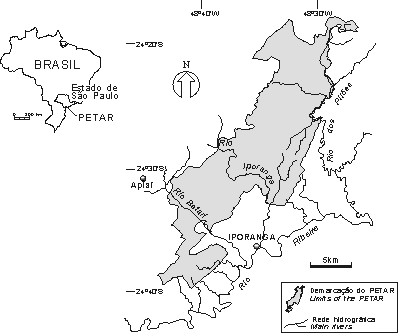
Figure 1 – Localization of the Upper
Ribeira State Park (PETAR)
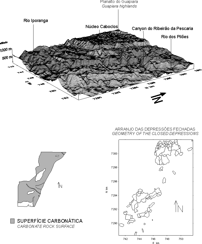
Figure 2 – Topographic compartimentation of
the northern area of Petar. Modified from Ferrrai et. al. 1999
Climate and vegetation
The area falls into a transitional climatic region between the hot
climate of low latitudes and the mesothermic temperate climate of middle latitudes which
is typical of the southern region of Brazil. NIMER (1977) classified the climate as warm
and wet with no dry season. The mean annual rainfall for the period 1970-1996 is 1,963.3
mm, which falls mainly in the wetter season from October to March (1,281.5 mm). Mean
annual temperatures usually lie between 20° C and 22° Cand annual temperature ranges are
also usually small due to the proximity of the ocean.
This climate allows the development of the Rain Forest (Alonso
1977) which is high and dense as a result of the variety of species, which belong to
different biological forms and levels of occupation. The highest trees reach 25-30m. The
large number of llianas, epiphytes, tree ferns and palm trees give to this forest a
typically tropical aspect.
Geology
The park lies in the Apiaí Fold Belt, underlain by metamorphic
rocks of the volcano-sedimentary supracrustal sequence of the Açungui Group, which is
divided into several tectonic blocks separated by NE-SW transcurrent shear zones (fig. 3;
Campanha 1991). PETAR occupies part of the Lajeado tectonic block between the Quarenta
Oitavas lineament to the North and the Figueira Fault at the South. This block is composed
of the low metamorphic grade Lajeado Subgroup which is composed of pelitic, psammitic and
carbonate units ovelain by a gabbro intrusion. The carbonate rocks are metacalcarenites
and impure calcitic and dolomitic metacalcilutites of the Bairro da Serra Formation;
metacalcarenites and laminated metacalcilutites of the Mina de Furnas Formation; and
dolomitic metacalcarenites of the Passa Vinte Formation. The first occupies the largest
area, both in PETAR and in the Lajeado block (fig 3).
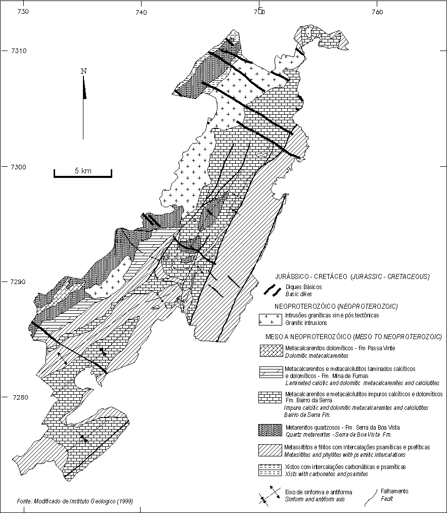
Fig 3.Geologic map of the Petar, adapted from
Campanha 1991 and IG 1999.
HISTORICAL ASPECTS AND PRESERVATION
The Betari river valley is a route between the Ribeira lowlands
and the Plateau which has been in use since pre-colonial times according to the
archeological findings of de Blasis and Robrahn (1998). In historic times, the route was
also used by explorers interested in finding mineral resources on the plateau.
Scientific study of the Upper Ribeira karst was started at the
beginning of this century by the naturalist Richard Krone, who investigated a number of
the caves in a search for paleontological, archaeological and ethnological material. The
results of his studies were published in the volume entitled "Exploração do Rio
Ribeira de Iguape", published by the Geographic and Geological Commission in 1914.
Later, Krone (1950) recounted the discovery of 41 caves, the finding of bones of the
Pleistocene megafauna, and called attention to the natural beauty and tourist potential of
the region. As a result of the 1908 expedition, a first attempt for conservation of some
of the caves in the area was taken with the disappropriation of areas around the Pescaria,
Monjolinho, Arataca and Chapéu caves in 1910.
Systematic exploration and mapping of the caves was started by
groups of the Brazilian Caving Society (Sociedade Brasileira de Espeleologia) and
technicians of the Geographical and Geological Institute (IGG; now the Geological
Institute of theState Environmental Agency – Secretaria Estadual do Meio Ambiente).
The publication "Limestone caverns – Speleological studies in the Upper Ribeira
river valley" of Guimarães and Lebret (1966) is an outstanding contribution from
this early phase.
The creation of a conservation unit in order to protect the caves
and surrounding forest dates from 1957 when the mining engineer José Epitácio Passos
Guimnarães of the IGG presented a proposal for the creation of a state park in the
region. This came out in 1958 with the promulgation of State Decree no 32,283
which created the juridical entity PETAR with an area of 35,712 ha. State Decree no.
41,626 of 1963 placed PETAR under the responsibility of the State Forest Service (now the
São Paulo State Forest Institute – IF/SP). As a result of mining interests in the
area, PETAR was reduced by 609.17 ha to 35,102.83 ha in 1969 by Decree no.
14,321.
A proposal to register PETAR and surrounding areas with scenic or
scientific interest was forwarded to the National Council for Preservation of the Natural,
Architectural and Archeological Sites (CONDEPHAAT) in 1969 with the intention of enlarge
the protected speleological area to include the source regions of underground rivers which
flow through the caves (Sanchez 1984). This was achieved with the registering of the
entire Serra do Mar (including the Serra de Paranapiacaba) as a Protected Environmental
Area (APA), forming the Serra do Mar APA.
The implantation of this park delayed until 1987-8, when the IF/SP
demarcated the park boundaries and started to employ the State Forestry Police to control
illegal deforestation by lumbering and harvesting of palm shoots.
The demarcation of PETAR was an important step towards the
preservation of the natural heritage. Nevertheless, the catchment area and part of the
main caves of the Pérolas – Santana and Areais cave systems continue outside the
park limits, and although these areas lie within the Serra do Mar APA, this does not
guarantee eficient protection. Some caves lie outside the park and other protected areas
around PETAR.
THE KARST LANDSCAPE
Karst topography
The general pattern of the carbonate belt of the Lajeado Subgroup
typically has the karst surface up to 700 m lower than surrounding crests of pelitic,
psammitic or granitic rocks (fig 2 and 4). This leads to the formation of mixed recharge
in the karst areas, with and important allogenic injection added to the authigenic
recharge.
Using groups of relief features, Karmann (1994) defined the
following morphological divisions in the Lajeado and Furnas-Santana areas of the
southwestern sector of PETAR in the Betari river basin:
The Contact zone is defined by insurgences (sinkholes) of
allogenic waters which together form a belt along the contact zone between limestone and
other rocks. Typical features of this zone are blind valleys, contact poljes and sinkholes
which absorb run-off from the insoluble rocks around the limestones. The zone is usually
marked by assymetric valleys in which the slope over the the limestones is often a rocky
escarpment. Cave entrances with breakdown halls are often associated to paleo sinkholes
which are today higher up above the rivers (foto 1). Blind valleys have drops of 260-580
m.
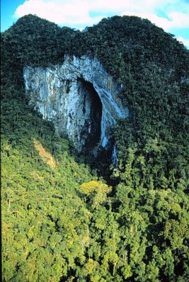
PHOTO 1- Aereal view of the
blind valley of the Casa de Pedra cave. Photo from João Allievi.
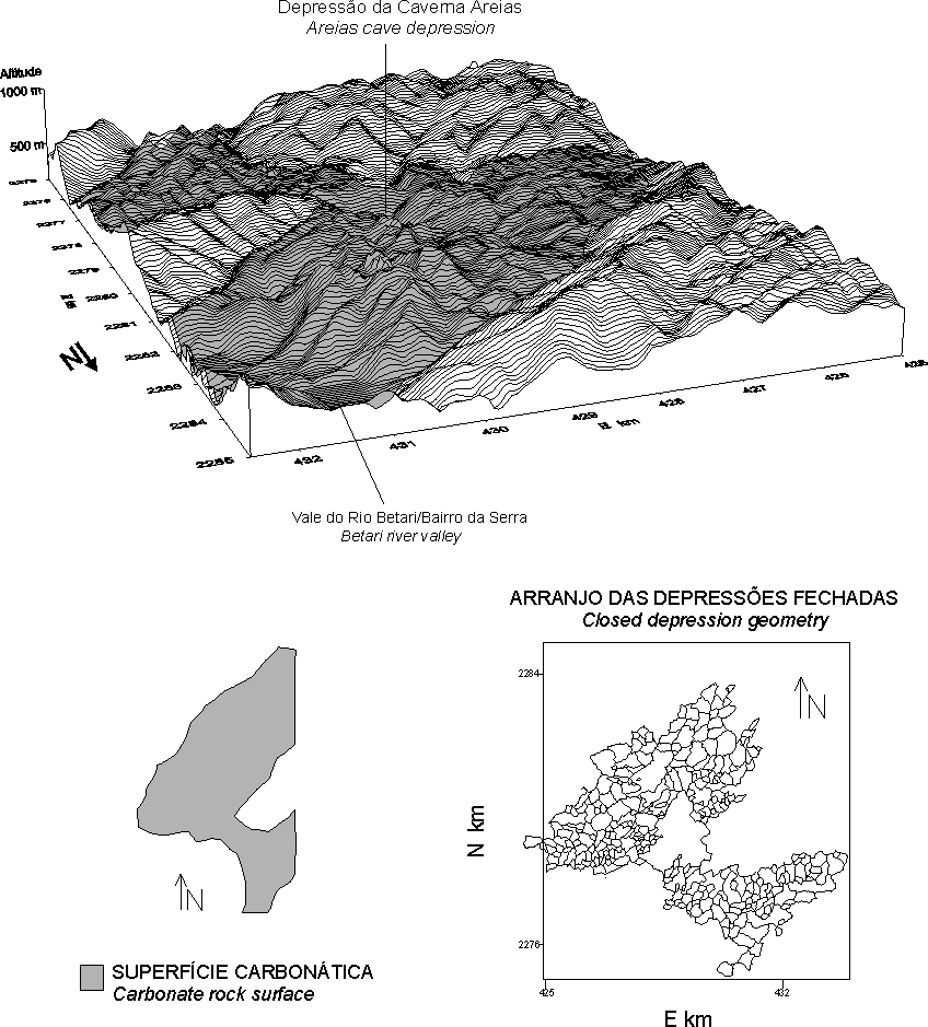
Fig 4.Topographic
compartimentation of the southeastern area of the Petar.
The fluviokarstic zone corresponds to that part of the
carbonate rock surface where run-off predominates, with rivers developed locally together
with karst features. Where the main rivers cross the carbonate rocks, such as where the
Betari river crosses the Lajeado carbonatic body at the Bairro da Serra, a morphological
situation is created in which fluvial features predominate over karstic features. In these
cases the river valley is wide, with a well-developed aggradation plain and a meandering
river channel. Karst is restricted to the valley slopes which have resurgences and cave
entraces. The widths of these valleys range between 60 and 1,100 m, in contrast to valley
widths of 20-40 m where the river flows over metapelites.
The polygonal karst zone is the typical landscape developed
over carbonate rocks where the authogenic surface run-off is completely absorbed by
sinkholes located at the bottom of depressions, and the watersheds have a polygonal
planform. (fig 5). The term polygonal depression is used in the sense defined by
Williams (1971) and Day (1976). In general this morpghological unit has a very undulating
surface with crests at 600-700 m and closed valley bottoms at 420-550 m, resulting in a
relief of about 130 m. In the northern part of PETAR a polygonal depression with a relief
of 630 m was discovered which represents one of the deepest in the carbonate belt of the
Lajeado Subgroup (Ferrari et al. 1999). One of the most representative areas of
polygonal karst occurs over the Lajeado body in the Southwest of PETAR where morphometric
analysis at the 1:25,000 scale led to the identification of simple and compound
depressions. Simple depressions have areas between 0.003 and 0.05 km2 and only
one sink-hole. Compound depressions are usually larger (between 0.05 and 0.8 km2),
and have more irregular outlines. The internal drainage system is more complex, up to
third order, with many sink-holes which interrupt the drainage channels but lack
watersheds at the analysed scale. The depths of the compound depressions usually vary
between 10 and 80 m with one exceptional example associated with the subsidence dolina
which leads to the entrance to the Areias caves I and II having a depth of 130 m. The
simple depressions are similar to Sweeting’s (1972) cockpits in Jamaican
karst, while the compound depressions are uvalas since they have many insurgence
points. At the lowest points of the poligonal depressions three types of dolines can
occur: solution dolinas with diffuse infiltration along widened fractures filled by
residual material; solution dolinas with infiltration concentrated along open vertical
conduits; and collapse dolinas with a direct connection to underground rivers and caves,
which were formed by the collapse of cave roofs. The second type of dolina gives acess to
most of the vertical caves or abysms which are very common in the region.
Karmann’s morphometric analysis (op. cit.) also showed
that the depression density is between 7.7 and 13 depressions per km2, typical
of tropical karst, such as those of Jamaica, Porto Rico (Day 1976) and New Guinea
(Williams 1972).
The sectors with best-developed polygonal patterns are the surface
expression of the main underground routes of cave systems. In some cases it is still
possible to identify segments of the paleo fluvial valleys which were present before the
installation of the polygonal basins with centripetal drainage.
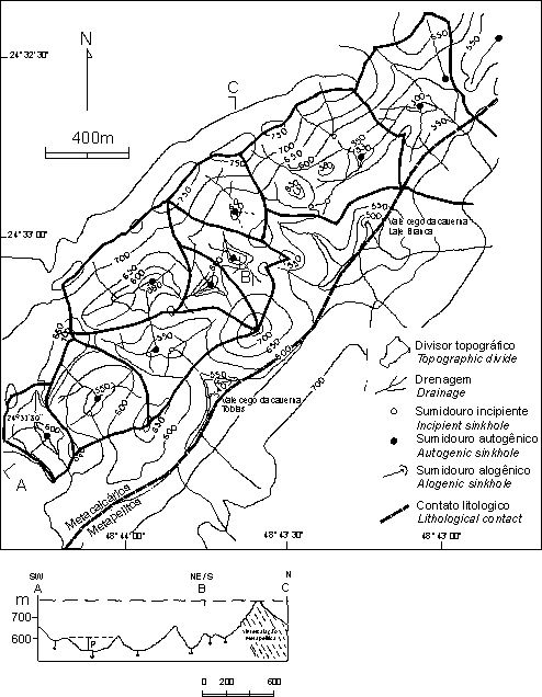
Fig 5. Distribuition of
poligonal closed depressions over the carbonatic belt of the Perolas-Santana cave system.
Adapted from Karmann 1994.
The morphological features in the north-eastern part of PETAR, in
the Iporanga and Pilões river basins, are very similar to those in the Betari basin
(Ferrari et al. 1999) with the exception of the karst canyons, present in the
Northeast and absent from the southwestern area. An example of this feature is the
Temimina river valley associated with the homonimous cave. The sources lie in the Guapiara
plateau on the Três Corregos granite. Where the stream crosses the limestones it runs
through a steep-sided valley until it reaches the sinkhole at the cave. The sinkhole
cannot be penetrated due to fallen blocks.
Cave systems
The scenic features of PETAR which are most sought after by the
public are the caves, with around 200 examples in the park and its surrounding areas. The
longest cave is Santana with 6,300 m, while the greatest drop of 297 m is found along the
Água Suja cave.
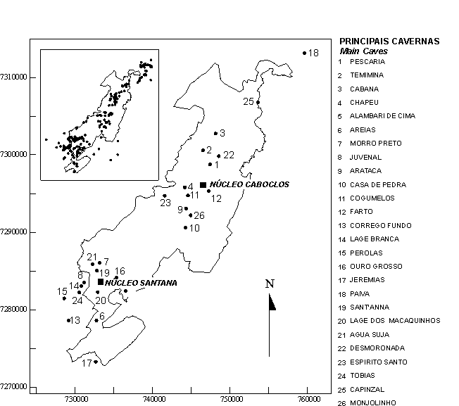
Fig 6. Localization of the main
caves with respect to the perimeter of the Petar. In the upper left, localization of caves
in the vicinity of the park.
Most caves represent accessible segments of groundwater
circulation routes, and thus form integrated underground drainage systems. The general
pattern of these systems is convergent, in which water collected from many sinkholes is
drained to a few resurgences. The ratio between alogenic sinkholes and resurgences in the
southwestern part of PETAR is between 8 and 12, demonstrating that the karstic circulation
has few branches (Karmann 1994). The main accesses to the underground rivers are the
sinkholes or the resurgences. 2,500 m of the 5,970 m between the sink-hole and the
resurgence of the Pérolas-Santana cave system are acessible, while the rest is almost
exclusively in the saturated zone according to Karmann (1994). The underground channels
are generally oriented to NE-SW and have resurgences along the main rivers (Betari,
Pilões and Pescaria) which cut the conduit systems representing their base levels.
The systems have high and very variable hydraulic gradients with a
mean of 65.6m/km and a variation coefficient of 86.4% for twelve measurements. Extreme
examples are the Ouro Grosso cave, with 221m/km, and the Água Suja cave, with 129m/km.
The planimetric cave patterns vary between angular and rectilinear
to curved and sinuous. In the Santana and Ouro Grosso caves long straight stretches with
sharp angular inflections predominate (fig 7) while the curved sinuous pattern
predominates in the Areias cave. The planform is a direct function of the dip of the rock
beds, which is the main control of the conduit shape: the steeper the dip (45-80° ), the
straighter and more angular the original cave conduit pattern, excluding the collapse
halls (Karmann, op. cit.).
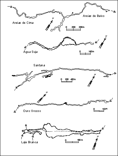
Fig 7. Samples of planimetric
cave patterns of the Petar. Arrows indicate the direction of water flow. Adapted from
Karmann 1994.
In transversal sections, vadose incisions (canyons) predominate
over phreatic conduits (fig. 8). The underground canyons have rectilinear or staggered
sections and meandering longitudinal sections, with active subterranean rivers and heights
in the range of 10-60m. The phreatic initiation zones are rarely preserved or accessible
and are mostly seen along smaller tributaries of the main courses in higher levels above
the present river level. Subterranean collapse scenery is common. The largest collapse
halls are in the Água Suja and Laje Branca caves, with 2.8 x 10⁵ and 1.7 x 10⁵
m3, respectively.
Another notable morphological feature of the Upper Ribeira caves
are the vertical conduits, generically called abysms. They were formed by capture of the
surface rivers by the carbonate rocks in which the subterranean drainage systems were
already well-developed. The abysms in the Ouro Grosso, Casa de Pedra and Água Suja caves
are spectacular examples. In the last cave, the Vargem Grande abysm, (popularly known as
the Foreign Debt!) is a vertical conduit which narrows upwards, and has a height of 95m
(fig 9). It is the connection between two cave levels with the Vargem Grande cave in the
upper level, and the Água Suja cave in the lower.
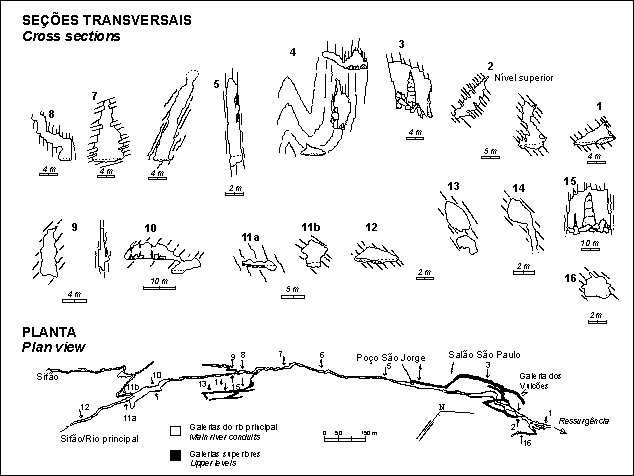
Fig 8. Plan view and
transversal sections of the Santana cave. Adapted from Karmann 1994.
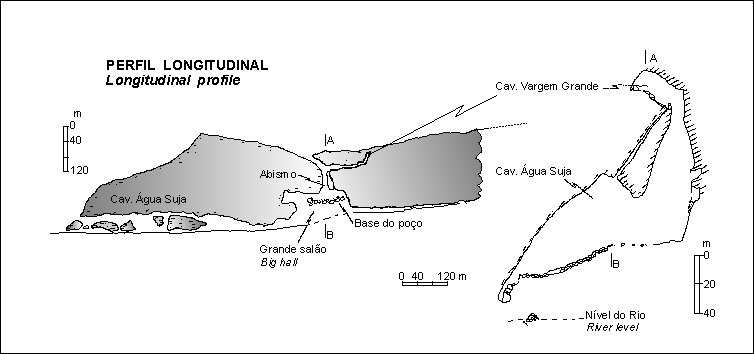
Fig 9. Longitudinal profile of
the Agua Suja cave. On the right, transversal section of the Vargem Grande abysm (the
"Foreign Debt abysm"). Adapted from Batistucci 1988.
Ages of the caves
Using the method of the uranium series (234U/230Th)
dating applied to secondary calcite deposited on subterranean river sediments of the
Santana, Pescaria and Alambari caves, Karmann (1994) estimated that the mean rate of
subterranean fluvial incision was 0.0042cm/y (4.2cm/ky) over the last 240,000 y. Using
this value to gauge the incision of the subterranean canyons, it was estimated that the
caves in the region have been developing for approximately 1.7 My, while a minimum age for
the Pérolas Santana cave system would be 2 My. This age includes the time necessary for
the initiation of phreatic conduits and the subsequent incision of the canyons by
underground rivers.
Speleothems
The PETAR caves stand out for the great diversity of shapes of the
speleothems. In decreasing order of abundance calcite, aragonite, hydromagnesite, gypsum,
hydroxyapatite and leucophosphite speleothems were identified (Barbieri 1993).
Calcite occurs in stalactites, stalagmites, curtains, helictites,
heligmites, rimstone dams, several types of flowstones, shields, cave pearls (ooliths and
pisoliths), cones, dogs’ teeth (calcite spar), rafts, and as one of the components of
moon milk deposits. Stalactites up to 15 m high with bases 3 m in diameter are notable,
and they have secondary growths forming piles of plates; tube-like stalactites
("straws") are up to 2 m long; helictites and heligmites are up to 1 m long and
have widths of 2 cm; decimetric helictites form tuffs; cones associated with travertine
dams have centimetric euhedral calcite crystals (dog tooth); curtains are decametric,
while shields reach 3m in diameter. Straw stalactites and helictites are usually composed
of monocrystals of hyaline or white calcite a few decimetres long.
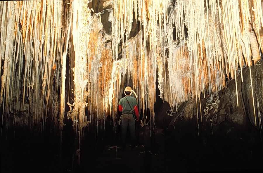
Foto 2
Aragonite forms stalactites, stalagmites, spathites and flowers
(anthodites). Its precipitation occurs when the molar Mg/Ca ratios in slowly-percolating
waters, derived from dolomitic strata within the dominantly calcitic limestones, exceeds
0.6. Calcite and aragonite frequently occur together, for example, where small secondary
anthodite growths of aragonite cover stalactites.
Hydromagnesite, which together with calcite forms moon milk, has
been identified at the tips of aragonite needles, in anthodites where it forms globules of
millimetric tuffs looking like cottonets, and as coatings over many types of speleothems,
when is has a dull, pasty appearance when wet (Barbieri 1993).
The only sulphate mineral so far identified in the PETAR caves is
gypsum. It forms small tuffs with undulating white fibrous crystals a few mm to 1 cm long,
or in the form of millimetre-thick crusts on the surfaces of altered limestone in the dry
sections of upper galleries.
The occurrence of phosphates identified by Barbieri (1993) is a
mineralogical curiosity. Leucophosphite and hydroxyapatite form friable brownish or
greenish crusts from a few mm to a few cm thick covering rock surfaces and speleothems.
PALEONTOLOGICAL SITES
In the Betari river basin, the Fossil, Juvenal and Ponta de Flecha
abysms are important sites for fossils of the Pleistocene - Holocene transition. In the
first and last abysms excavations in clastic sediments were undertaken using archeological
techniques. The sedimentas are poorly-sorted and immature, consisting of fragments from
cobbles to clay-size. They contain a large quantity of organic matter and therefore have a
dark grey colour, and some levels have carbonate cement. They are usually reworked by
recurrent floods which destroy the stratigraphy. They accumulated at different levels
along vertical staggered conduits or in horizontal conduits. Thicknesses are very variable
but rarely achieve a few m. The thickest excavated deposit was 1.3 m thick.
Amongst the extinct forms identified are teeth, skull fragments
and different bones belonging to Toxodon platensis. A large quantity of fossil
bones found in the abysms are attributed to the order Edentata, such as Eremotherium
lundi, Megatherium sp., (giant sloths) Nothrotherium sp. and Scelidotherium
cuvieri. The giant armadillo Gliptodon calvipes was found in the Fossil abysm
(Barros Barreto et al. 1982). A interesting point is the possible coexistence of
megafauna species such as Toxodons and Megatheriums with pre-colonial man in the Upper
Ribeira, as shown by the presence of bones and teeth of the animals with dismemberment and
meat-carving marks identified in material from the Ponta de Flecha abysm (Barros Barreto et
al., op. cit.)
PARK ORGANIZATION AND VISITING
PETAR is divided into two main areas for visits, the Santana
Nucleus in the southern part, and the Caboclos Nucleus in the northern part. Tourist
routes starting from that points have been planned, with escorts of local guides who are
employees of the park.
The importance of PETAR in the ecotourism scene in southeastern
Brazil is shown by the number of visitors received during the period between 1996 and
1998, which varied between 24,831 and 28,859 per year (Allegrini 1999).
General information on the park can be obtained from the
IF/SEMA/SP, or at the Internet site www.iflorestsp.br
Bibliography
Alonso, M. T. A -1977- Geografia do Brasil - Região Sudeste.
IBGE - Rio de Janeiro. 667 p.
Allegrini, M. –1999- Documentos básicos para o plano de
manejo do PETAR. Instituto Florestal, SEMA-SP.
Barbieri, A.J.-1993- Depósitos minerais secundários das
cavernas Santana, Pérolas e Lage Branca, município de Iporanga, São Paulo. São
Paulo, 96 p. (Dissertação de Mestrado - Instituto de Geociências/USP).
Barros Barreto, C.N.G.; De Blasis, P.D.; Dias Neto, C.M.; Karmann,
I.; Lino, C.F.; &. Robrahn, E.M -1982 - Abismo Ponta de Flecha: um projeto
arqueológico, paleontológico e geológico no médio curso de Ribeira de Iguape, São
Paulo. Revista de Pré-História, vol. 3(4): 195-215, USP.
Campanha, G.-1991- Tectônica proterozóica no Alto e Médio
Vale do Ribeira, Estados de São Paulo e Paraná. São Paulo, 296p. (Tese de
Doutoramento - Instituto de Geociências/ USP).
Day, M.-1976- The morphology and hydrology of some Jamaican karst
depressions. Earth-Surface Processes 1(2): 111-129.
De Blasis, P. e Robrahn, E.M. -1998 - Investigações
arqueológicas no Médio/Baixo Vale do Ribeira de Iguape, SP. Revista do MAE, v. 8
:
Ferrari, J.A.; Hiruma, S.T. e Karmann, I. –1999-
Caracterização morfométrica da superfície cárstica do núcleo Caboclos (PETAR). Revista
do Instituto Geológico, 13(1-2): ......
INSTITUTO DE PESQUISAS TECNOLÓGICAS DO ESTADO DE SÃO PAULO-
IPT-1981a- Mapa geomorfológico do Estado de São Paulo, escala 1:1.000.000. São
Paulo, Secretaria da Indústria, Comércio, Ciência e Tecnologia do Estado de São Paulo
e IPT (Publicação IPT no 1183).
Instituto GeolÓgico -1999- Contribuição ao conhecimento do meio
físico no Parque Estadual Turístico do Alto Ribeira - PETAR (Apiaí e Iporanga, SP).
Coordenadoria de Informações Técnicas, Documentação e Pesquisa Ambiental, Secretaria
de Estado do Meio Ambiente - São Paulo. 241 p.
Karmann, I. -1994- Evolução e dinâmica atual do sistema
cárstico do alto Vale do rio Ribeira de Iguape, sudeste do estado de São Paulo. Tese
de doutoramento IGc-USP. 241 pp.
Krone, R.-1914- Informações ethnographicas do valle do rio
Ribeira de Iguape. In: COMMISSÃO GEOGRAPHICA E GEOLÓGICA DO ESTADO DE SÃO PAULO (ed.) Exploração
do Rio Ribeira de Iguape. 2a edição, São Paulo, p. 24-34.
Krone, R.-1950- As grutas calcárias do vale do rio Ribeira de
Iguape. O I.G.G., 8(3): 248-297 (transcrição do vol. VX, Arquivos do Museu
Nacional, 1909, Rio de Janeiro).
Le Bret, M.-1966- Estudos espeleológicos no vale do Alto Ribeira.
Boletim I.G.G., 47: 71-123, São Paulo.
Nimer, E. –1977- Geografia do Brasil - Região Sudeste. IBGE
- Rio de Janeiro. 667 p.
Sánchez, L.E.-1984- Cavernas e paisagem cárstica do Alto Vale do
Ribeira/SP: uma proposta de tombamento. Espeleo-Tema, 14: 9-21.
Sweeting, M.M.-1972- Karst landforms. New York, Mcmillan,
362p.
Williams, P.W.-1971- Illustrating morphometric analysis of karst
with examples from New Guinea. Zeitschrift für Geomorphologie Neue Folge, 15:
40-61.