
SIGEP
Geological and Paleontological
Sites of Brazil - 029
VILA VELHA
Date: 18/11/1999
Mário Sérgio de Melo 1
Élvio Pinto Bosetti 1, 2
Luiz Carlos Godoy 1, 2
Fernando Pilatti 2
1 Departamento de
Geocięncias. msmelo@uepg.br
2 Núcleo de Estudos em Meio Ambiente - nucleam@uepg.br
Universidade Estadual de Ponta Grossa.
Praça Santos Andrade s/n. CEP 84010-790 - Ponta Grossa-PR, BRAZIL
© Melo,M.S.; Bosetti,E.P.; Godoy,L.C.; Pilatti,F. 1999. Vila Velha. In: Schobbenhaus,C.; Campos,D.A.; Queiroz,E.T.; Winge,M.; Berbert-Born,M. (Edit.) Sítios Geológicos e Paleontológicos do Brasil. Published
18/11/1999 on Internet at the address http://www.unb.br/ig/sigep/sitio029/sitio029.htm [Actually
https://sigep.eco.br/sitio029/sitio029.htm
]
[SEE
PRINTED CHAPTER IN PORTUGUESE]
(The above bibliographic reference of author copy rights is required for any use of this article in any media, being forbidden the use for any commercial purpose) |
ABSTRACT
The natural sandstone sculptures of Vila Velha are an impressing
example of ruiniform relief, combining the association of erosive processes with
pre-existing attributes of the rocks. They are protected by a State Park, which has
received about 200,000 visitors/year, what causes some risks for the preservation of such
a rich natural environment.
The Vila Velha Sandstone is part of the base of the ltararé Group
(Upper Carboniferous to Lower Permian of the Paraná Basin, Southern Brazil). It has a
reddish coloration due to the presence of ferriferous cement. Grain size is medium to fine
sand, with dispersed argillaceous intraclasts in an incipient planar to cross-bedded
stratification.
The natural sculptures have an elevation of 10 to 30 m above
surrounding terrain. Their tops show cracks and fracture polygons, while the walls show
saliences, hollows, small anastomosing tunnels, alveolar erosive excavations, basal
concave surfaces and fractures filled with iron and manganese oxides. Other structures are
the sedimentary stratification, vertical and horizontal fractures and pseudo
stratification formed by the cementing.
Vila Velha is a natural site with great environmental value. The large
outcrop is a singular exposure of the sedimentary attributes and erosive features of the
Vila Velha Sandstone. The area is appropriate for environmental study activities, not only
because of the ruiniform relief but also the presence of natural preserved ecosystems,
with endemic endangered species. Nevertheless, the integrity of this environment is
threatened by the massive exploration of the touristic aspect, which has failed to
attribute to the park its role of a preservation area.
INTRODUCTION
Vila Velha (Old Village) is the denomination of an notable group
of natural sculptures of ruiniform aspect, developed in Carboniferous sandstones of the
Paraná Basin. Situated approximately 80 Km WNW from Curitiba and 20 Km ESE of Ponta
Grossa, for a long time Vila Velha has been pointed as a well-known touristic attraction.
The singularity of the sculptures enforced the creation of the Vila
Velha State Park by the State Law # 1292, of October 12, 1953. The park, 3,122.11 ha
large, is much older than the Brazilian environmental legislation and this determined the
divergence of aims of the three institutions that are responsible for its administration.
The sandstone sculptures have received a variety of names suggested by
the imagination of the visiting public: Cyclops city, camel, sphinx, ship's prow, bottle,
turtle, wine-glass (the symbol of Vila Velha) and others. The heights range from a few
meters to about 30 meters. The erosive forms are distributed on an area of about 10 ha,
that is a notable outcrop of periglacial sandstones of non-consensual genesis, where the
sculptures reflect the interrelation of various factors: lithology of the sedimentary
rock, tectonic and non-tectonic structures, weathering and erosion processes, beyond
others.
LOCALIZATION
Vila Velha is situated in the Municipality of Ponta Grossa, in the
Campos Gerais region, State of Paraná, Southern Brazil (Figure 1), on the geographical
coordinates 25o14'09''S and 50o00'17''W. The main access is the
BR-376, and important road junction that connects the shores, Curitiba (the State capital)
and the North of the Paraná State.
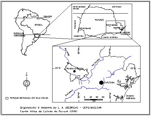
Figure 1. Location of Vila Velha Site
HISTORY
The first white men who saw the Campos Gerais region were the explorers
from Săo Paulo (named bandeirantes paulistas) of the XVI century: Aleixo Garcia in
1526, Pedro Lobo and Francisco Chaves in 1531. It is also described that the Spanish Dom
Álvar Nuńez Cabeza de Vaca, Governor of Paraguay in 1541, also came to this region.
In the XVII century, expeditions from Săo Paulo visited the region
looking for gold and precious stones, as well to capture Indians. As told by Ferreira
& Kersten (1990),
this was the time of the first references to Vila Velha, because it
was a natural mark for the travelers going south.
For the tribal populations, ancient inhabitants of the region, the
ruiniform sculptures of Vila Velha were explained by a variety of legends, some of them
still told nowadays. The most known is the legend of ITACUERETABA, the
"extinct city of stone".
In 1876 the First Geological Commission of the Brazilian Empire visited
the region of the Campos Gerais. At that time, Luthero Wagoner described the Carboniferous
sandstones and Devonian fossils on underlying layers, these later named "Ponta Grossa
Formation" (Formaçăo Ponta Grossa) (Lange,
1954).
In 1880, the Emperor of Brazil, D. Pedro II, visited the region to know
the project of the Russian-German colonization, started in 1878. He stayed in the
farmhouse of Domingos Pereira Pinto, the Baron of Guaraúna, in whose lands the strange
rock formation was placed.
DESCRIPTION OF THE AREA
Vila Velha is sculptured on Carboniferous sandstones of the Paraná
Basin, that is a vast intracratonic depression of South America, about 1,400,000 km2
in area, extending over Brazil (1,100,000 km2), Argentina (100,000 km2),
Paraguay (100,000 km2) and Uruguay (100,000 km2) (Zalán et al.,
1991; Milani
et al. s.d.) (Figure 2).
The Paraná Basin Sedimentary Filling
The basin is filled by up to 8,000 m of sedimentary and volcanic rocks,
the later to a maximum depth of 1,700 m (Zalán
et al., 1991).
The older sediments
(Rio Ivaí Group) are from the Late Ordovician to Early Silurian (Assine
et al., 1994;
Milani et al. 1994),
and the newer (Bauru and Caiuá Groups) are from the
Early Cretaceous (Fernandes
& Coimbra, 1994).
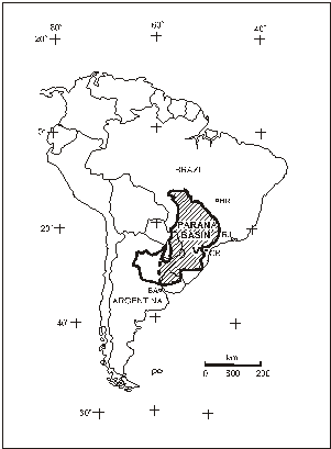
Figure 2 . Paraná Basin and the Vila Velha Site. V: Vila Velha; CR:
Curitiba; RJ: Rio do Janeiro; BR: Brasília; BA: Buenos Aires.
Geology of Vila Velha
Vila Velha is placed near the eastern border of the Paraná Basin,
about 10 km westward the erosive contact of the Paleozoic sedimentary units over the
Proterozoic basement (Figure 3).
The rocks of this basement (Açungui Group of the Brazilian Cycle and
post-tectonic granitic stocks) form the Primeiro Planalto Paranaense (the First
Paraná Plateau), which landscape is leveled between 800 and 900 m above sea level. The
Paleozoic sedimentary units of the Paraná Basin form the Segundo Planalto Paranaense
(Second Paraná Plateau), which is leveled by a planation surface gently inclined towards
the west, with maximum altitudes in the east at about 1,100 m. The limit between the First
and Second Paraná Plateau is called the "Devonian" Escarpment, that is locally
named Serra de Săo Luís do Purună, a mainly erosive cliff up to 200 m high.
In this sector of the Paraná Basin occurs the Furnas Formation
(basal), that grades to the top to the Ponta Grossa Formation. The Itararé Group lies
above these two units, showing clear erosive contacts.
Vila Velha is formed by reddish sandstones of the basal portion of the
Itararé Group, that also has conglomerates, diamictites, rhythmites, argillites and
shales (Maack,
1946a).
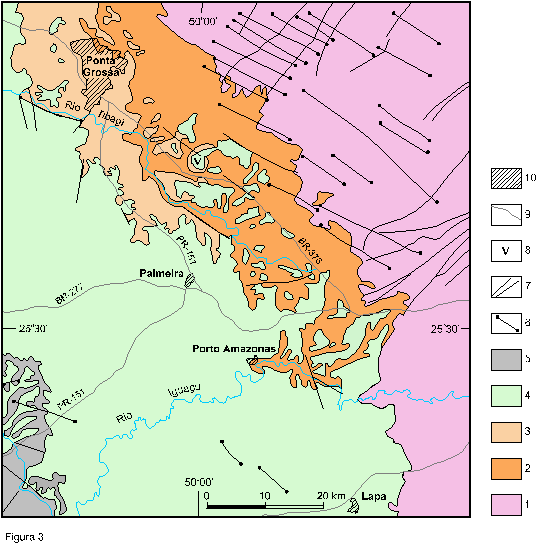
Figure 3. Geologic map of Paraná State between Ponta Grossa and Lapa
(MINEROPAR, 1989). 1: Proterozoic basement; 2: Furnas Formation (D); 3: Ponta Grossa
Formation; 4: Itararé Group (C-P); 5: Rio Bonito Formation (P); diabase dykes (Mesozoic);
7: major faults; 8: Vila Velha; 9: urban areas.
Stratigraphy and Paleoenvironments
Maack
(1946b), named "Vila Velha" the reddish sandstones that
form the natural sculptures . Recent researchers are not unanimous about the origin,
stratigraphic setting and the age of these sandstones and underlying deposits of the
Itararé Group.
França
et al. (1996) considered the Vila Velha sandstone as
subaqueous lobes formed by dense gravitational flows coming from the base of coastal
glaciers. Evidence of hydrodynamic flows indicates shallow water environment, with the
shifting of gravitational flows and hydrodynamic processes. The sedimentary filling of the
upstream subaqueous channel of the lobes of the Vila Velha Sandstone is represented by the
Lapa Sandstone, which shows a linear morphology to the south of Vila Velha. The fossil
content of layers included in the Lapa Sandstone permitted to date it to the Westphalian
age (Upper Carboniferous). The Lagoa Azul Formation, also with an Westphalian age, is the
basal unit of the ltararé Group, and comprises the deposits underlying the Vila Velha and
Lapa sandstones
(Milani et al.,
1994) (Figure 4).
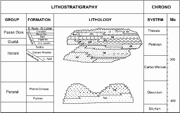
Figure 4. Local Stratigraphyc chart (modified from Milani et al.
s.d.)
Canuto
et al. (1997) also recognized a genetic relation among
the Lapa Sandstone southward, and the Vila Velha Sandstone northward, this latter at least
in part underlying the former. In this alternative model the Lapa Sandstone is seen as the
filling (up to 80m thick) of a subglacial tunnel-valley carved on older sedimentary rocks
of the Itararé Group, and reaching the Furnas Formation (Devonian) towards the north. The
Lapa Sandstone is included in the Itararé Group, but with an uncertain age. Lithosome
geometry, low dipping cross-stratification and vertical and horizontal burrows suggest a
tidal influenced shallow marine setting for the Vila Velha Sandstone.
Lithology
The Vila Velha Sandstone shows a few examples of clear sedimentary
structures. Incipient bedding and massive-like rocks (Maack, 1946a)
and the presence of
dispersed argillaceous intraclasts suggest resedimentation by gravitational flows. Ripple
marks and low-dipping cross-stratification indicate the influence of hydrodynamic
processes (França
et al., 1996), maybe in a marine environment influenced by the
tides
(Canuto et al.,
1997).
The Vila Velha Sandstone is up to 50 m thick (Maack,
1946a). It overlies
conglomeratic sandstones and sandy-clayey rhythmites of the Itararé Group with a
concordant contact. The sandstone is a reddish quartzous sedimentary rock with variable
sorting. Grain size varies from fine to coarse sand, with basal conglomerate levels. The
sandstone minerals are quartz, feldspars (partly weathered to kaolin), muscovite, chlorite
and garnet. (Maack,
1946a) also described the role of a thin film of iron and manganese
oxides in the shape of many of the Vila Velha natural sculptures. This cementing process
combined with differential erosion cause the formation of common mounds with wide tops and
concave eroded basis (Maack,1946a)
(Figure 5).
Iron and manganese oxides cementation is a marked feature of the Vila
Velha Sandstone, being the main cause of the colors and shapes that make up the local
scenic heritage. The oxides occur as the cement that joins the quartz grains and also as
veins a few centimeters thick that fill vertical and horizontal rock fractures. Cementing
is clearly a secondary process, and sometimes forms pseudostratification crossing the
sedimentary structure.
Petrography analysis of samples from different levels of the natural
sculptures revealed that the Vila Velha Sandstone is formed by quartz grains, with rare
polycrystalline (quartzite) grains and lithic fragments of argillaceous layers, that can
generate pseudomatrix (Melo
& Coimbra,1996). The minerals described by
Maack
(1946a),
such as feldspars, muscovite, chlorite and garnet should occur only in the layers below
the most typical sandstones of Vila Velha.
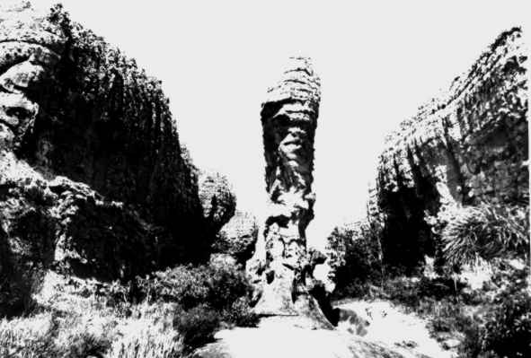
Figure 5. Sandstone sculpture with enlarged top showing horizontal
non-tectonic fractures.
The grain size of the sandstones varies from fine to coarse sand, with
a predomination of medium sand. Sorting is moderate to poor, and the grains are
sub-rounded to rounded and occasionally sub-angular. The framework is closed, and the
quartz grains show concave-convex to sutured contacts. Sometimes there is a secondary
growth with euhedral development in secondary pores (Melo & Coimbra,
1996).
Adding to the ferruginous cementing, the Vila Velha Sandstone also
presents a precipitation of manganese oxide, that fills the fractures of the NE-SW and E-W
systems. It forms continuous metallic veins a few centimeters thick and unequal cementing
of the surrounding sandstones, as botryoidal fringes about 1 cm thick (Melo
et al., 1999).
Fracture trends
The Paraná Basin shows three main trends of tectonic structures
(Zalán
et al., 1991):
a) NE-SW parallel to the structures of the Proterozoic basement;
b) NW-SE, related to the Gondwana break-up;
c) E-W parallel to oceanic fracture zones.
These three trends of structures appear in Vila Velha, mainly as long
fractures with no or negligible displacement.
Other two sets of fractures appear in the sandstones (Melo
& Coimbra, 1996):
d) subvertical fractures of non-tectonic origin, exhibiting a
concentric setting parallel to the borders of the rocky plateau;
e) subhorizontal structures partially controlled by bedding and formed
by relaxing stresses due to load removal.
Forms of the Landscape
The Vila Velha plateau is a "ruined inselberg" (AB'SÁBER
1977), that is sustained by very eroded sandstones. This contrasts with other nearby
sandstone inselbergs, less destroyed by the erosion. This difference indicates that the
Vila Velha plateau is in a more advanced erosion stage than the neighbouring inselbergs,
giving rise to an exception landscape, marked by "the extravagance of its topographic
forms, called ruiniform relief" (Ab'
Sáber, op. cit., p.3).
The top of the plateau is at 1,012 m above sea level, about the same
elevation of the top-surface of the Second Paraná Plateau. The main rivers of the region
(Tibagi, Guabiroba) have their riverbeds at about 785 m above sea level.
The natural sandstone sculptures are 10 to 30 m high, corresponding to
the thickness of the reddish sandstones with ferruginous cementing, that are harder and
tend to support plateaux of the landscape. The height of the sculptures can be lower (a
few meters), when the erosive processes have isolated them from the rockwalls and lowered
their original height.
The forms of the sculptures remember towers, sand-clocks, walls, with
different ornamentations that reflect the characteristics of the rocks, the fractures and
the erosive processes (Figures 5 and 6).
The age of the eroded figures is interpreted by geomorphologic
correlation. Vila Velha is placed in the Second Paraná Plateau, that is a southward
extension of the Depressăo Periférica Paulista. These two geomorphologic
provinces are levelled by a Neogene planation surface (Soares
& Landim, 1976;
Melo et al. 1998). Besides, an important phase of lateritization with associated ferriferous
cementing is recognised in Southeastern and Southern Brazil, in the limit
Pliocene-Pleistocene (QUEIROZ NETO 1974, PENTEADO 1976, MELO et al. 1978), though
the erosion of the ruiniform sculptures is post-Neogene.
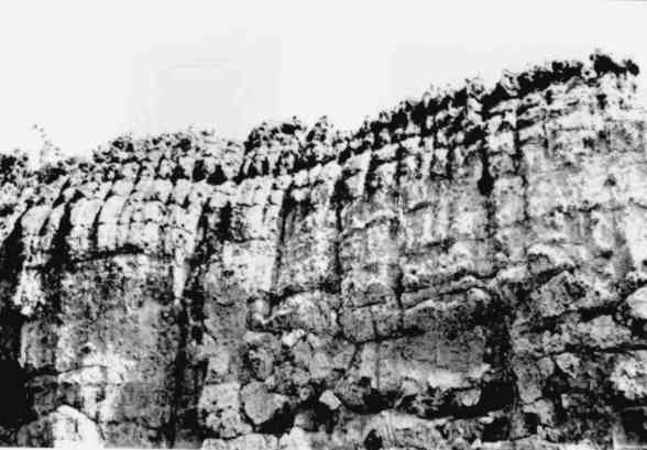
Figure 6. Lapiés-like features in the top of the sandstone plateau.
Erosive Processes and Features
The main erosive agents in Vila Velha are rainwater, organisms (plants,
animals and lichens) and the insolation.
Rainwater that flows overland causes mechanical erosion, dissolution
and reprecipitation. The mechanical erosion with associated dissolution of the cement can
form lapiés-like features in the top of the plateau (Figure 6). In the cliffs they
can form vertical hollows that evolve to isolated tower-like features, with enlarged tops.
As the rainwater drains the rockwalls they also promote the excavation
of superficial holes, in a process named "alveolar erosion" (Fortes,
1996). It
results from the combined action of mechanical erosion and dissolution of some components
(Figure 7). Otherwise, mainly in the northern rockwalls that are more exposed to the
sunlight, surface waters reprecipitate a thin coat of iron oxide, which protects the
sandstone from erosion. When rich in organic acids from vegetation decomposition, the
superficial waters, more corrosive, can dig long and narrow furrows on the surface of the
plateau.
The rainwater that penetrate the rock massif through the fractures and
pores can also give rise to strange excavation features, named "anastomosing
tunnels" (Fortes,
1996). Usually such features show apertures of a few centimeters
closely controlled by the horizontal fractures. Corrosion cones present in the
anastomosing tunnels resemble dissolution and precipitation features (Figure
7), but in
this case they must be regarded as a result of mainly mechanical erosion.
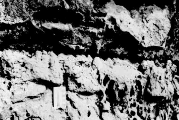
Figure 7. Corrosion cones formed by anastomosed tunnels in horizontal
fractures and alveolus due to superficial erosion.
Organic activity (tree roots, lichens, ferns, orchids, mosses,
termites, swallows and "blackbirds") is co-responsible for the processes of
degradation of the rocks. Lichens are abundant on the damp walls of the sculptures, which
occur mainly where there is no direct sunlight. This contributes to create favorable
conditions for the erosive processes, as in the formation of concave surfaces in the base
of the sculptures, and in the deepening of fractures, alveolus and tunnels.
The sun heating on the surface of the sandstone creates cracks from the
phenomenon of constant expansion and contraction. This originates many of the fractures on
the plateau and on the walls of its northern face. When the sandstones are uniform
(massif-like) the cracks tend to form regular hexagons, which are the shapes that require
less energy for rupture (Figure 8). The action of rainwater and organisms then opens and
deepens the superficial fractures initiated by insolation.
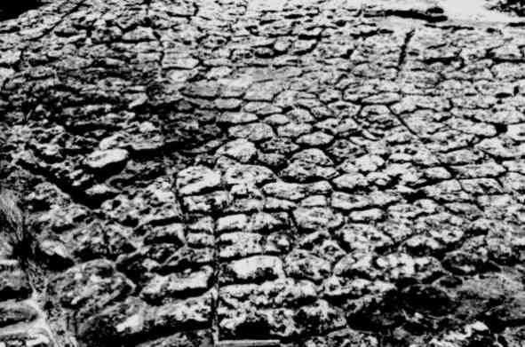
Figure 8. Polygonal fractures attributed to insolation associated to
linear subvertical fractures.
Recently, besides the natural factors that promote the erosion of the
sandstone, large numbers of tourists have resulted in deep erosion of the paths, while
vandals' inscriptions are destroying the rockwalls.
There was no evidence found that eolian processes added in the
elaboration of the natural sculptures in Vila Velha, but this has been told by some
authors (v.g. Soares,1975;
Ab'Saber, 1977).
The concave bases of some of the forms
are attributed to differential erosion of less resistant layers, because of different
textures and cementing by iron oxide, what control water percolation and lichens growth.
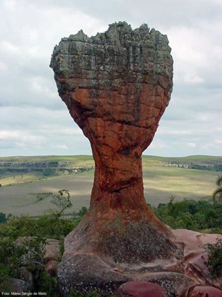
Figure 10. The
Wine-glass, sandstone natural sculpture symbol of Vila Velha.
(Photo: Mario Sergio de Melo)
PROTECTION PROCEDURES
Vila Velha is not only a notable geologic/geomorphologic monument, but
also an important conservation area for the ecosystems of the Campos Gerais region. The
State Park comprises preserved areas of Araucaria (Paraná pine tree) woods, open
fields and swampy depressions. There are at least 27 species of endemic vegetation in
these ecosystems (Hatschbach & Moreira Filho,1972).
These environments are inhabited by a number of animals menaced of
extinction (such as the guará wolf - Chrysocyon brachyurus), which belong to the
Guarani Fauna Province (Mello
Leităo,1947).
The following arrangements must be envisaged for improving the
preservation and use of the park:
- Land use policy for the park and surrounding areas;
- Recuperation of damaged areas;
- Implementation of environmental educational programs;
- Environmental monitoring;
- Removal of restaurants and swimming pool from the sandstone area;
- Pavement of the trails with sandstone and scenic treatment;
- Implementation of research and tourist support centers;
- Implementation of a regional ecotourism program.
BIBLIOGRAPHIC REFERENCES
Ab´Saber,A.N. 1977. Topografias ruineformes no Brasil. Săo Paulo, USP -
Inst. Geografia, Geomorfologia, n.50, 14p.
Assine,M.L.;
Soares,P.C.; Milani,É.J.
1994. Seqüęncias tectono-sedimentares mesopaleozóicas da Bacia do Paraná,
Sul do Brasil. Revista Brasileira
de Geocięncias,24(2):77-89.
Canuto,J.R.;
Rocha-Campos,A.C.;
Sato,P.E.S. 1997. The Late Paleozoic
Lapa Sandstone (Itarare Subgroup): a possible tunnel-valley fill?.
Anais da Academia
Brasileira de Cięncias,69(2):275-276.
Fernandes,L.A.;
Coimbra,A.M. 1994. O Grupo
Caiuá (Ks): revisăo estratigráfica e contexto deposicional. Revista
Brasileira de Geocięncias,24(3):164-176.
Ferreira,D.D.;
Kersten,M.S.A. 1990. Mitos e Histórias
de Vila Velha. Boletim de Antropologia, Curitiba,3(4):59-74.
Fortes,F.P.
1996. Geologia de Sete Cidades. Teresina, Fundaçăo Cultural
Monsenhor Chaves, 144p.
França,A.B.;
Winter,W.R.; Assine,M.L.
1996. Arenitos Lapa-Vila Velha: um modelo de trato de sistemas subaquosos
canal-lobos sob influęncia glacial, Grupo Itararé (C-P), Bacia do Paraná.
Revista Brasileira
de Geocięncias,26(1):43-56.
Hatschbach,G.;
Moreira Filho,H.
1972. Catálogo Florístico do Parque Estadual de Vila Velha (Estado do
Paraná-Brasil). Boletim, UFPR, v.28, p.1-54, set.
Lange,F.W.
1954. Paleontologia do Paraná. In.: Paleontologia do Paraná.
Curitiba. Comissăo de Comemoraçăo do Centenário do Paraná. p. 1-105,
dez.
Maack,R.
1946a. Geologia e geografia da regiăo de Vila Velha e consideraçđes sobre
a glaciaçăo carbonífera do Brasil. Curitiba, Arquivos do Museu
Paranaense, v.5, 305p.
Maack,R.
1946b. Notas preliminares sobre uma nova estratigrafia do Devoniano do
Estado do Paraná. In: Congresso
Pan-Americano de Engenharia de Minas e Geologia, 2, Rio de Janeiro. Anais...
Rio de Janeiro, v.4.
Mello
Leităo,C. 1947. Zoogeografia do
Brasil. 2ed. Săo Paulo, Companhia Editora Nacional. Biblioteca Pedagógica
Brasileira, série 5, v.77.
Melo,M.S.;
Cuchierato,G.;
Coimbra,A. 1998. Níveis planálticos
da porçăo centro-leste do Estado de Săo Paulo e sedimentaçăo associada.
Curitiba, Bol. Par. Geoc., v.46 (in press).
Melo,M.S.; Coimbra,A.M.
1996. Ruiniform relief in sandstones – the example of Vila Velha,
Carboniferous of the Paraná Basin, Southern Brazil. Barcelona, Acta Geológica
Hispanica,31(4):
25-40. (published in 1999).
Melo,M.S.; Coimbra,A.M.;
Sayeg,I.J.; Giannini,P.C.F.; Atencio,D. 1999. Fringed
cryptomelane/hollandite in the Vila Velha Sandstone telogenesis. Săo Paulo,
Acta Microscopica, v.8(A):35-36.
Milani,É.J.;
França,A.B.; Schneider,R.L.
1994. Bacia do Paraná. Boletim.
Geoc. PETROBRÁS,8(1):69-82.
Milani,É.J.;
Faccini,U.F.; Scherer,C.M.;
Araújo,L.M.; Cupertino,J.A.
s.d. Sequences and stratigraphic hierarchy of the Paraná Basin (Ordovician
to Cretaceous), Southern Brazil. Săo Paulo, Boletim do IG-USP (in
press).
Soares,O.
1975. Geologia. In: Requiăo, R. (Ed.), Ponta Grossa - História, Tradiçđes,
Geologia, Riquezas. Ponta Grossa, Requiăo e Cia., p.87-92. (Publicaçăo
Comemorativa do 152° Aniversário de Ponta Grossa).
Soares,P.C.;
Landim,P.M.B. 1976. Depósitos cenozóicos
na regiăo Centro Sul do Brasil. Campinas. Notícia Geomorfológica,16(31):17-39.
Zalán,P.V.;
Wolff,S.; Conceiçăo,J.C.J.;
Marques,A.; Astolfi,M.A.M.;
Vieira,I.S.; Appi,V.T.;
Zanotto,O.A.
1991. Bacia do Paraná. In Gabaglia, G.R. and Milani, E.J. (Eds.) Origem
e evoluçăo de bacias sedimentares. Rio de Janeiro, PETROBRÁS,
p.135-168.