|

SIGEP
Geological and Paleontological
Sites of Brazil - 021
Moutonnée
Rock from Salto, São Paulo state
Date:21/03/2000
Antônio
Carlos Rocha-Campos
acrcampos@usp.br
Instituto de Geociências – USP
Rua do Lago, 562 -
05508-900 São Paulo
© Rocha-Campos,A.C. 2000. Moutonnée Rock from Salto, São Paulo state. In: Schobbenhaus,C.; Campos,D.A.; Queiroz,E.T.; Winge,M.; Berbert-Born,M. (Edit.) Sítios Geológicos e Paleontológicos do Brasil. Published
21/03/2000 on Internet at the address
http://www.unb.br/ig/sigep/sitio021/sitio021english.htm
[Actually https://sigep.eco.br/sitio021/sitio021english.htm ]
[SEE
PRINTED CHAPTER IN PORTUGUESE]
(The above bibliographic reference of author copy rights is required for any use of this article in any media, being forbidden the use for any commercial purpose)
|
ABSTRACT
The roche moutonnée associated with glacial rocks of the Itararé Subgroup, near Salto, central-eastern State of São Paulo, is the only example of this kind of glacial abrasion feature known in the late Paleozoic of the Paraná Basin.Though only partially preserved, the structure still displays the characteristic shape and glacial abrasion features typical of Recent and Pleistocene roche moutonnées. Discovery of the moutonnée in 1946 strongly supported the interpretation of a glacial origin for the associated rocks of the Itararé Subgroup and demonstrated a northwestward sense of movement of the late Paleozoic glacier in the northern Paraná Basin.
The structure was eroded from Neoproterozoic granite and is overlain by rocks of the Itararé Subgroup interpreted as subglacial deposits formed during glacier advance and subaqueous sediments deposited during subsequent retreat of the ice. The roche moutonnée from Salto lies inside the Parque Rocha Moutonnnée (Roche Moutonnée Park), that provides adequate conditions for the conservation of this important geological monument.
INTRODUCTION
The present geological site aims at protecting the remains of the only example of
roche moutonnée[1] found associated with the glaciogenic deposits of the Itararé Subgroup (Permo-Carboniferous) in the Paraná Basin, located near the town of Salto, in central-eastern São Paulo State. The roche moutonnée is carved out of Neoproterozoic granite, which is part of the basement of the Paraná Basin.
A roche moutonnée is a geomorphic feature of mesoscale (1m to 1km of length), in the form of a boss or rocky elevation, of asymmetrical profile, having a less inclined, glacially polished and eroded, upglacier (stoss) side and a more irregular, steeper downglacier (lee) face made by plucking or quarrying of rock fragments from the basement. It is, therefore, a stoss and lee type of glacial erosional feature or streamlined molded form. The theory of the origin of roche moutonnées implies the formation of a subglacial cavity downglacier from a previously existing basement high over which the glacier is sliding. The cavity is generated by variation in vertical presssure exerted by the glacier on the rock obstacle. It is more intense on the stoss side resulting in abrasion and formation of striae and less intense on the lee side where plucking predominates. This process is helped by variation in pressure of subglacial meltwater. The morphology of the moutonnées is highly influenced by the structure of the basement rock, which leads to variation in shape of these structures.
Although several other features generated by glacial abrasion during the late Paleozoic glaciation such as striated pavements and surfaces eroded, respectively, on hard substratum and intraformationally on soft beds have been recorded in the Paraná Basin of Brazil (Rocha-Campos, 1967; Frakes and Crowell, 1969; Santos et al., 1996; Rocha-Campos et al., 1998), other structures of the moutonnée type have not yet been found. In fact, there is only scarce information in the literature on roches moutonnées associated with late Paleozoic glaciogenic deposits of South American Gondwana.
Uncontrolled commercial extraction of the local granite during decades in Salto greatly reduced the exposed area of the roche moutonnée. Fortunately, remains still preserved exhibit a set of characteristic features that merit preservation. Besides its typical morphology, the roche moutonnée contains other small scale erosional features described below that make it an important record of the glaciation that affected Southeastern Brazil during the Permo-Carboniferous. In addition to representing inequivocal evidence of the glacial origin of Itararé Subgroup rocks (Almeida, 1948; Rocha-Campos, 1967; Frakes and Crowell, 1969; Santos et al., 1996), discovery of the roche moutonnée permitted the first correct interpretation of the sense of movement of the late Paleozoic glacier in the northern part of the Paraná Basin. Since then the rock has become one of the most important outcrops related to Gondwana glaciation, attracting the attention of Brazilian and international researchers. It is a mandatory visiting site that is included in geological field trips to the Gondwana of the Paraná Basin (Rocha-Campos et al., 1972; 1988).
LOCATION
The roche moutonnée of Salto crops out on the outskirts of the urban area of Salto, SP, some 96 km northwest of São Paulo, on the northwest side of the municipal road, now Rodovia Rocha Moutonnée (Rocha Moutonnée Road), that links the Rodovia da Convenção (Convention Highway; SP-75) with the Rodovia do Açúcar (Açúcar Highway, SP-79).
(Figure 1.) The outcrop lies within the Parque Rocha Moutonnée (Rocha Moutonnée Park), installed around the exposure. Total area of the park is 43,338 m2. The locality may be reached directly from the Rodovia do Açúcar, departing from km 33 northward along the Rodovia Rocha Moutonnée.
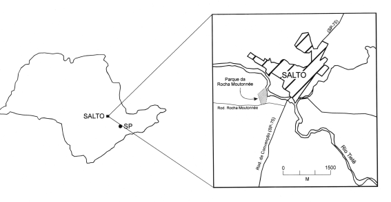
Figure 1 - Location of the site.
HISTORY
The outcrop of the roche moutonnée was discovered by Marger Gutmans, a researcher of the Instituto Agronômico de Campinas (Campinas Agronomical Institute), in 1946. Gutmans presumably reported its discovery at a meeting of the Sociedade Brasileira de Geologia (Brazilian Geological Society). The first published description of the rock is due to Almeida (1948). The author recognized the typical asymmetrical profile of the structure and the presence of glacial erosional features on it. He also described rocks of the Itararé Subgroup that locally overly the moutonnée, later assigned to the Itu Formation (Barbosa and Gomes, 1958).
From the features of the moutonnée, Almeida (1948) correctly deduced the northwestward sense of movement of the late Paleozoic glacier in this part of the Paraná Basin, a topic that had been and still remained controversial for several years afterwards (Leinz, 1937; Rocha-campos, 1967). Later studies (Martin, 1961; Rocha-Campos, 1967; Frakes and Crowell, 1969; Santos et al., 1996) confirmed the eastern provenance of glaciers that influenced late Paleozoic deposition in the northern part of the Paraná Basin.
Discovery of the roche moutonnée thus furnished an important definitive evidence for the glacial origin of diamictites and associated rocks of the Itararé Subgroup and the sense of movement of late Paleozoic ice. Relevance of these data for the interpretation of sedimentary environments and paleogeography of the late Paleozoic glacial deposits is unanimously recognized in the national and international literature on Gondwana glaciation (Rocha-Campos, 1967; Frakes and Crowell, 1969).
SITE DESCRIPTION
Less than one-third of the original structure is presently preserved inside the Parque Rocha Moutonnée
(Figure 2 and 3). The exposure includes part of the southeastern stoss or upglacier and of the lee or downglacier faces of the rock, totalling about 21 m in length and 2-3 m of exposed height. Straight and subparallel to slightly divergent striae (mm wide) and furrows (up to a few cm wide) may be observed on the stoss side as well as on the southwestern and upper faces of the moutonnée. Viewed from above, striae tend to curve broadly around the southeastern flank of the rock. General orientation of striae varies from
N18oW-N53oW. Almeida (1948) described crescentic marks and short striae originating from holes from where minerals had been removed from the granite. These features are now less visible due to weathering of the rock surface. An excellent example of crescentic mark is still preserved on the southwestern face of the rock
(Figure 3). As a whole, glacial erosional microfeatures in Salto are similar to ones found in typical Recent and Pleistocene moutonnées. The entire northeastern flank of the rock has been removed by commercial extraction of granite. Seen from the former quarry area, the structure still maintains the asymmetrical profile of the moutonnée. The steeper downglacier face forms an irregular set of steps resulting from the removal of rock fragments by glacial plucking or quarrying controlled by mostly vertical joints oriented N11oE, N61oE, N81o-86oE and N121oE. Discontinuous and relatively thin masses of conglomeratic sandstone and sandy diamictite are found strongly plastered against the upglacier face of the moutonnée filling a depression in the granite, and laterally along the souththwestern face of the rock. These lithologies are overcompacted and show an irregular and discontinuous foliation/bedding. They are interpreted as having been deposited subglacially during glacial advance, possibly by lodgement (lodgement tillite). These rocks are transitionally overlain along the southwestern face of the moutonnée by brown shales and laminites of siltstone and argillite containing dropstones (cm-dm in size). In the section exposed to the southeast of the upglacier face of the structure the laminites and argillites intercalate with lenses of fine grained sandstone and overlie, in fault contact, a deformed, sandy, yellow diamictite. The diamictite, several meters thick, is massive to coarsely stratified and contains rounded to subangular clasts of varied composition (mostly of crystalline rocks), up to dm in size, some faceted and striated. Deformation of the diamictite includes faults and folds. While the laminites and shales are interpreted as subaqueous deposits possibly associated with the retreat of the glacier, the origin of the diamictite is less clear. It could represent another type of subglacial till formed by melt out during glacier retreat or stagnation and subsequently deformed by a later advance of the glacier.
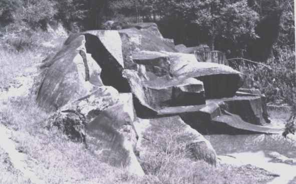
Figure 2 - General view of the roche moutonnée from the southeast showing part of its upglacier (stoss) surface bearing strie and a patch of rock filling a depression in the granite.
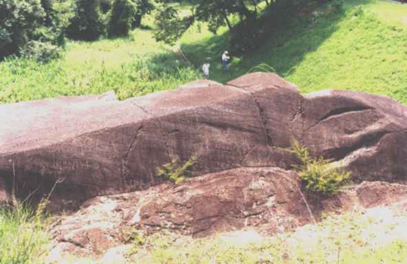
Figure 3 - View from the SW showing the lateral face of the rock bearing striae and a crescentic mark (about halfway up the inclined surface). Note bed of coarse sediments compressed against the structure.
The granite of the local basement is part of a regional batholith (Itu granite), amply exposed over the wide valley where the park is located. Other outcrops occur to the northeast of the park. In this area small pieces of the undulated basement bearing striae trending paralllel to those on the moutonnée have been described (Amaral, 1965). The radiometric age of the granite of around 580 Ma assigning it to the late Neoproterozoic.
The roche moutonnée probably formed by glacial abrasion contemporaneously to the deposition of the Itararé rocks that immediately overlie the structure. In view of its position close to the eastern margin of the Paraná Basin these rocks have been interpreted as of basal stratigraphic position within the Itararé succession (Barbosa and Gomes, 1958; Rocha-Campos. 1967; Frakes and Crowell, 1969). Palynological data from the Itu varvite (p. ), possibly correlatable with rocks from Salto, are contradictory, indicating either older (late Carboniferous) or younger (early Permian) ages for the varvite, within the late Paleozoic. Paleogeographic and stratigraphic considerations, however, suggest correlation of the Itu and Salto rocks with the upper part of the Itararé section.
In addition to the asymmetry of the structure, the local southeast to northwest sense of movement of the late Paleozoic glacier that eroded the moutonnée is also indicated by the orientation of the crescentic mark and the microfeatures found on the moutonnée. The roche moutonnée and associated rocks document an advance of the late Paleozoic glacier in the area, moving northward, eroding the granite and depositing patches of lodgement till. This phase was followed by the retreat of ice and deposition of stratified sediments in a water body as well as the melt out till.
PROTECTIVE MEASURES
Several initiatives taken by the state and municipal governments described below have finally provided protection for the important geological monument represented by the roche moutonnée of Salto.
a) registration of the area containing the geological monument by the Secretaria de Estado da Cultura de São Paulo (Secretariat of State of Culture) in 1990 under the recommendation of the Conselho de Defesa do Patrimônio Histórico, Arqueológico e Artístico do Estado de São Paulo (CONDEPHAAT, Council for the Protection of the Historical, Archeological and Artistic Patrimony of the State of São Paulo);
b) expropriation of the above and surrounding area, amounting to 43,338 m2, by the Municipality of Salto in 1990;
c) creation of the Parque Rocha Moutonnée (Roche Moutonnée Park) in the above area by the Municipality of Salto. Inaugurated in 1991, the park was the first in Brazil planned and established with the objective of conserving a monument of exceptional scientific interest, while at the same time providing protection for the ecologic values of the area and offering opportunities for recreation and environmental and scientific education. The park contains all the necessary infrastructure to meet its objectives and is frequently visited by the general public, students of several levels, and researchers from Brazil and abroad.
ACKNOWLEDGEMENTS. I thank Paulo R. dos Santos, José R. Canuto, Ivo Trodstorf Jr. and Alexandre Tomio for their help during field work in Salto and Itu. I am also grateful to Paulo R. dos Santos for his comments to the text and to Thomas R. Fairchild for the review of the English version. This paper is a contribution to the Projeto Temático: Controles tectônico, climático e paleogeográfico das características, gênese e preservação dos depósitos glaciais pré-cenozóicos do Brasil”, supported by FAPESP (Grant 91/0546-2)
REFERENCES
Almeida, F.F.M. 1948. A “roche moutonnée” de Salto, Estado de São Paulo. Boletim de Geologia e
Metalurgia(1948), 5:112-118.
Amaral,S.E. 1965. Nova ocorrência da rocha moutonnée em Salto, São Paulo. Boletim da Sociedade Brasileira de
Geologia(1965),14:71-82.
Barbosa, O.; Gomes, F.A. 1958. Pesquisa de petróleo na Bacia do Rio Corumbatai, Estado de São Paulo. Departamento Nacional da Produção Mineral, Divisão de Geologia e Mineralogia, Boletim 171, 40p.
Frakes, L.A.; Crowell,I.C. 1969. Late Paleozoic glaciation I, South America. Geological Society of America
Bulletin (1969),80:1007-1042.
Leinz,V. 1937. Estudo sobre a glaciação permo-carbonífera do sul do Brasil. Departamento Nacional da Produção Mineral, Divisão do Fomento da Produção Mineral, Boletim 21, 47p.
Martin,A. 1961. The hypothesis of continental drift in the light of recent advances of geological knowledge in Brazil and in South-West Africa. Geological Society of South Africa
Transactions(1961), 64, 47p.
Rocha-Campos,A.C. 1967. The Tubarão Group in the Brazilian portion of the Paraná Basin. In: J. Bigarella; R.D. Decker; I.D. Pinto (eds.), Problems in Brazilian Gondwana Geology, Curitiba, p.27-102.
Rocha-Campos, A.C.; Oliveira, M.E.C.B.; Santos, P.R.; Saad,A.R. 1972. Late Paleozoic geology of Northern Paraná Basin. In: International Symposium on Carboniferous and Permian Systems in South America, Excursion Guide-Book, Instituto de Geociências, USP, p.3-13.
Rocha-Campos,A.C.;
Santos,P.R.; Canuto,J.R. 1988. Sedimentology and stratigraphy of the Gondwana
sequence in São Paulo State. In: 7th Gondwana Symposium, Excursion B2
Guide-Book, Instituto de Geociências, USP, 40 p.
Rocha-Campos, A.C.; Santos, P.R.; Canuto,J.R. 1998. Multiple, striated, soft sediments surfaces in the late Paleozoic and Proterozoic of Brazil. Anais da Academia Brasileira de
Ciências(1998), 71:841.
Santos, P.R.; Rocha-Campos, A.C.; Canuto,J.R. 1996. Patterns of late Paleozoic deglaciation in the Paraná Basin, Brazil. Palaeogeography, Palaeoclimatology,
Palaeoecology(1996),125:165-184.
[1] Although the term moutonnée (from the French: shaped like a sheep) has costumarily been assigned to the shape of the structure as similar to a resting sheep, it is more probable that the name was derived from a type of wavy wig in use in France during the 18th century.
[Back]
Back to HOME
PAGE 